Showing 25660 items
matching plenty-township-estate
-
 Whittlesea Historical Society Inc.
Document - Letter, Photocopy, William Lockwood to Education Department regarding Scrubby Creek School, 1887, unknown
Mr. William Henry Lockwood (of Whittlesea, Victoria) with his wife Naomi, née Bullock, and their children, James, Joseph, Mary, Martha and Wilhelmina. The Lockwood family were early settlers of Whittlesea. William Henry Lockwood was born in Glossop, Derbyshire c.1832. He migrated to Victoria on the first voyage of the Marco Polo in 1853 and married Naomi Bullock in St. Peter’s Church of England Melbourne on 27th December 1856. They had nine children, four of whom died in infancy and were buried in Yan Yean Cemetery. The family lived in Whittlesea in a two-storey home, which faced Church Street. William was a talented engineer and architect. He commenced work as a contractor and surveyor for the Whittlesea Roads’ Board and became Whittlesea Shire Engineer in the 1870’s. He continued in this role until his death in 1912. During his time as engineer he built many buildings, bridges and roads within the Whittlesea Shire including the Whittlesea Courthouse and the Whittlesea State School. On two of our local bridges, which were constructed during 1901, he was the engineer and builder. These are the Darebin Creek Bridge in Bridge Inn Road, Wollert and the Barber’s Creek Bridge in Plenty Road, Yan Yean. Both bridges are no longer in use. The Bridges are Monier reinforced concrete with bluestone abutments and were designed by Sir John Monash. In addition to his engineering work he was Postmaster and Registrar of Births, Deaths and Marriages for Whittlesea. He was appointed as inaugural treasurer of the Shire of Whittlesea in January 1875 and was actively involved in other community organisations. In the last few years of his life he continued working in spite of ill health. In her diary, his wife Naomi documented his last months. One entry reads, “16 Oct 1911 My husband in his office with Shire Secretary comparing books for audit”. After William’s death his daughter, Martha Hannah became Postmistress and another daughter, Wilhelmina Naomi Priscilla became Registrar for Whittlesea. A third daughter Sister Mary Emma was involved in charity work throughout Victoria working for the children of Sutherland Homes. She also appears to have acted as Registrar at Whittlesea after her sister Wilhelmina died in 1923. William Henry Lockwood died on January 12th 1912. The local community held him in high esteem for his contribution to the Whittlesea area. His wife Naomi died 22nd December 1912. The Lockwood family grave can be seen at Yan Yean Cemetery.1 page, photocopy of a hand written letterLetter dater 17 January 1887, from W. H. Lockwood, Draper, Grocer, Ironmonger, Post Office Store, Church St, Whittlesea, and Silvery Creek, Plenty Rangeslockwood, scrubby creek school -
Surrey Hills Historical Society Collection
Document - Contract of sale, Contract of sale for 33 Kingston Road, Surrey Hills
No 33 Kingston Road is a red brick attic-style house which was built c1920. Edward Edwards (1880-1963) was a blacksmith and the first owner. The house was named 'Berwyn' (Ref: 1931 electoral roll). Edward's wife was Mary Kennedy Stewart (1873-1931). They had 7 children, all born before the family came to Surrey Hills: 1. Hazel Margaret Kennedy Edwards (1896-1966) - dressmaker in 1931 electoral roll 2. Edward Alexander Edwards (1898-1988) 3. Mary Gwendolyn Edwards(1899-1942) 4. Gladys Annie Edwards (1902-1988) - hairdresser in 1931 electoral roll 5. Clarence Edwards (1906-1988) - plumber in 1931 electoral roll 6. Alan Stewart Edwards (1909 - 1996) 7. Geoffrey Ellis Edwards (1910-1985). The property passed to Edward Henderson Redpath after Edward Edward's death. He was a mechanic. (Ref: 1963 electoral roll). He was born in Shilbottle England on 3 December 1904 and married Gladys Annie Edwards in 1932 (#8417). He served in the Australian Airforce during WW2. Thus, the property was owned by the same family for over 40 years. Edward Henderson Redpath sold the property to David Murray Flynn and Heather Rosemary Flynn of 18 Kingston Road, Surrey Hills in 1965. Associated records: 1. Letter from George Henderson P/L to T Redpath, 1965 2. Letter re estate of E H Redpath, 1969. A standard folded real estate contract of sale for 33 Kingston Road, Surrey Hills, dated 14 August 1965edward edwards, berwyn, 33 kingston road, mary stewart kennedy, mary stewart edwards, houses, real estate contracts, legal documents, hazel margaret kennedy edwards, edward alexander edwards, mary gwendolyn edwards, gladys annie edwards, clarence edwards, alan stewart edwards, geoffrey ellis edwards, edward henderson redpath, gladys annie redpath, david murray flynn, heather rosemary flynn, house names -
Southern Sherbrooke Historical Society Inc.
Map - photocopy
A photocopy taken from the original land sale map provided to the society through Karel Coxell of Stockdale & Leggo. The original maps are stored in large bound account books and were originally the propert of McNally Real Estate. The books are held (in 2A3 photocopy of plan of survey of part of Crown Allotments 20 & 21, section C, parish of Narre Worran, County of Mornington. Clements Ave and environs in Belgrave Heights"Villette Estate" in top LH corner, "Locality Plan" in bottom LH corner, "Not in sale" written on one block and crossed out. All handwritten in pencil on original. "Colby Drive " and "Verona Street" added in pencil to copy.land sales, advertisements, subdivision -
 National Vietnam Veterans Museum (NVVM)
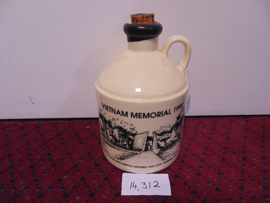
Memorabilia, Port Crock, Vietnam Memorial 1992 (Large)
Front-Vietnam Memorial site- Canberra Reverse- Picture of troops Vietnam- Black and white Side Map of Vietnam For All Those who suffered and died Vietnam 1962-1973Mt Aitken Estates-Australia Picture on reverse- Operation In Vietnamport decanter, vietnam memorial -
 National Vietnam Veterans Museum (NVVM)
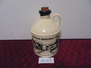
Memorabilia, Port Crock, Vietnam Memorial - 1992 (small)
Front- Vietnam Memorial - Canberra Reverse- Coloured Picture of Troops in Vietnam Side- Map of Vietnam For All Those who suffered and died Vietnam 1962-1973Mt Aiken Estates - Australia Picture on reverse - Operation in Vietnamport decanter, vietnam memorial -
Tatura Irrigation & Wartime Camps Museum
file, State Rivers & Water Supply Commission
This collection was owned by Keith Daniel, an accountant with SR & WSC. Resident in Tatura 6-7 years until 1965File containing - Victorian Government Gazette March 6, 1968. - - Map, Goulburn Irrigation System - Murchison A, SR & WSC Journal "Aqua" April 1966 , Lake Eppalock Boating Guide, "Aqua Summer 1991, Brochure & newspaper adv. re: Waranga Lakeside estate.1974 -
 Marysville & District Historical Society
Postcard (item) - Colour postcard, Scancolor (Australia) Pty Ltd, Marysville, Pre 2009
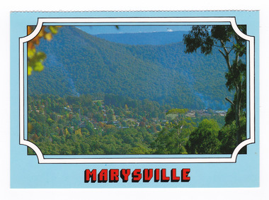
A colour photograph of the view of Marysville from Cumberland lookout.A colour photograph of the view of Marysville from Cumberland lookout. This postcard was produced by Scancolor Australia as a souvenir of Marysville.MARYSVILLE Victoria - Australia View to Marysville township from Cumberland/ lookout. scancolor Australia (03) 555 1944 CS 4064marysville, cumberland lookout, victoria, scancolor australia, postcard, souvenir -
 Marysville & District Historical Society
Postcard (item) - Colour postcard, Scancolor (Australia) Pty Ltd, Marysville, Pre 2009
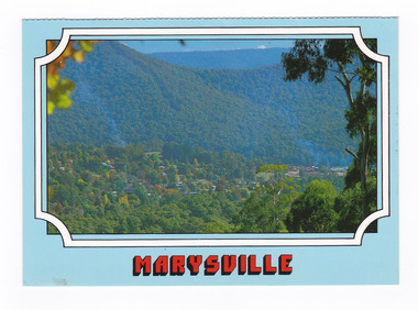
A colour photograph of the view of Marysville from Cumberland lookout.A colour photograph of the view of Marysville from Cumberland lookout. This postcard was produced by Scancolor Australia as a souvenir of Marysville.MARYSVILLE Victoria - Australia View to Marysville township from Cumberland/ lookout. scancolor Australia (03) 555 1944 CS 4064marysville, cumberland lookout, victoria, scancolor australia, postcard, souvenir -
 Churchill Island Heritage Farm
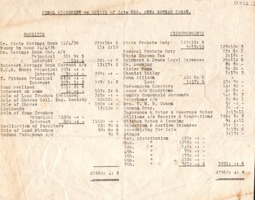
Document - Carbon Copy of Estate of Mrs Anna Hannah Gahan, c. 24/04/1936
Dr Harry Jenkins owned Churchill Island from 1936 to 1963 and bequeathed it to Margaret Campbell on his death. Sister Campbell had been nurse to his disabled son and wife and she lived on the island from the time of World War Two. The item was given to Arthur Evans, a family friend, on the day of the auction sale of artifacts when she sold the island, approximately 1973. This carbon copy of the estate of Mrs Anna Hannah Gahan shows the price and value of Churchill Island at the time of her death.Carbon copy of the Final Statement of the Estate of Mrs Anna Hannah Gahan, relative of the wife of Harry Jenkins, Alice. Document is typed in two columns with an itemised list of the complete estatemrs. anna hannah gahan, alice gahan, alice jenkins, harry jenkins, churchill island, jenkins, farm, gahan, statement, deceased estate, 1973, auction, arthur evans -
Whitehorse Historical Society Inc.
Newspaper - Article, Ian Armstrong, 2/06/1976
Article in Nunawading Gazette about local real estate agent, Ian Armstrong who has attended the World Real Estate Congress in San Francisco. 300 Australians attended.real estate, armstrong, ian, f.i.a.b.c.i. world congress, international real estate federation congress -
 City of Kingston
Pamphlet - Colour, Highett Town, 1888
Sales plan for land in the suburb of Highett, bounded by Highett Road, Worthing Terrace and the railway line, and incorporating Major Street and Train Street.The developing urban area of Highett within the City of Kingston. This land sale pamphlet illustrates the subdivision of land within the municipality and the changing demographic of the district as new houses are constructed close to infrastructure.Colour pamphlet advertising for private sale the Station Entrance Estate, Highett. Incorporates a map of the estate bordered by Wickham Road, Railway Parade, Highett Road and Point Nepean Road.land sales, highett -
Kew Historical Society Inc
Plan - Tramway Estate, Camberwell North, 1937
Subdivision plans and real estate flyers/brochures reveal a number of aspects of urban development and history. The Kew Historical Society's collection of these plans, as well as advertisements extracted from magazines, cover key aspects of community development and architectural history of Kew and Kew Eat as well as surrounding suburbs. While most of the plans in the collection were gifted to the Society by the former City of Kew, a number of other plans and advertisements have been donated by individuals, of which this is an example.Single page subdivision plan listing properties for sale in the Tramways Estate, Camberwell North. The large estate was bounded by Doncaster Road, Burke Road, Marwan Avenue, Maud Street, Severn Street, and extended over Glass's Creek at Mayland's Avenue. Within the plan, lots 3 to 342 are listed as lots. The plan includes annotations in ink indicating the prices realised by a number of lots. A key explains that lots with an 'H' represent a house, whereas the 37 shaded lots represent those being offered by this agent. subdivision plans -- camberwell (vic.), tramways estate -
 Eltham District Historical Society Inc
Photograph, Shire of Nillumbik World War One Memorials tour, 10 August 2016, 10 August 2016
As part of a program to acknowledge the Anzac Centenary Nillumbik Shire Council partnered with Yarra Plenty Regional Library to provide a bus tour with commentary of local sites of significance. These included Eltham township, the Shire of Eltham War Memorial at Kangaroo Ground, Christmas Hills, Hurstbridge memorial recreation park and finished at Eltham Library to view the Writing the War exhibtion at Eltham Library Community Gallery. The Shire of Eltham War Memorial at Kangaroo Ground War Memorial Park with fire spotting tower additon. Born Digitalworld war 1, war memorials, shire of nillumbik, kangaroo ground, memorial park, war memorial, fire spotting tower -
 Eltham District Historical Society Inc
Photograph, Shire of Nillumbik World War One Memorials tour, 10 August 2016, 10 August 2016
As part of a program to acknowledge the Anzac Centenary Nillumbik Shire Council partnered with Yarra Plenty Regional Library to provide a bus tour with commentary of local sites of significance. These included Eltham township, the Shire of Eltham War Memorial at Kangaroo Ground, Christmas Hills, Hurstbridge memorial recreation park and finished at Eltham Library to view the Writing the War exhibtion at Eltham Library Community Gallery. Shire of Eltham War Memorial with fire spotting tower at Kangaroo Ground War Memorial Park Born Digitalworld war 1, war memorials, shire of nillumbik, kangaroo ground, shire of eltham war memorial -
 Eltham District Historical Society Inc
Photograph, Shire of Nillumbik World War One Memorials tour, 10 August 2016, 10 August 2016
As part of a program to acknowledge the Anzac Centenary Nillumbik Shire Council partnered with Yarra Plenty Regional Library to provide a bus tour with commentary of local sites of significance. These included Eltham township, the Shire of Eltham War Memorial at Kangaroo Ground, Christmas Hills, Hurstbridge memorial recreation park and finished at Eltham Library to view the Writing the War exhibtion at Eltham Library Community Gallery. Dennis Ward (right hand side) of "The Friends of Kangaroo Tower" gives a brief presentation about the site. Born Digitalworld war 1, war memorials, shire of nillumbik, kangaroo ground, kangaroo ground memorial, tour, dennis ward -
 Greensborough Historical Society
Advertising Leaflet, Barry Plant Greensborough, 156 Nell Street Greensborough, 27/10/2018
156 Nell Street Greensborough, 3 bedroom home auctioned 31 August 2013, sold for $620,0002 page colour real estate leaflet, folded in 3.nell street greensborough -
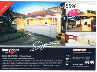 Greensborough Historical Society
Advertising Leaflet, 12 Greta Street Greensborough, 24/03/2012
12 Greta Street Greensborough, 4 bedroom home, auctioned 24 March 2012 for $670,000Real estate advertising leaflet, printed in colour on one sidegreta street greensborough -
 Greensborough Historical Society
Advertising Leaflet, 6 Mine Street Greenhills, 24/11/2012
6 Mine Street Greenhills. 3 bedroom home, auctioned 24 November 2012, sold December 2012 for $580,000; re-sold November 2014 for $632,000Real estate advertising leaflet, 1 sheet, printed in colourmine street greensborough -
 Federation University Historical Collection
Plan, Berry Bank Estates
This plan is associated with former Ballarat School of Mines Student Richard Squire (1875-1876). Gift of the Squire FamilyPlan of Berry Bank Estates. Coloured plan on cream paperberry bank estates, mining, happy valley, lake rosine estates, strathvean estates proprietary, w. luplaupitfield plateau, british banner, federal mint, moller, morrow, south pitfield consols, east banner, new lallah rookh, bull dog company, mindai, j. morpoh, poliah, f. j. morrow, piggoreet east, w. m. acheson, grand trunk, field's claim south grand trunk, south grand trunk, woady yalloak creek, mount misery creek, fitzpatric's creek, illabrook creek, great western, mount bute syndicate, narringhill creek, little woady yalloak creek, piggoreet east preemptive right, southern birthday, new birthday, prince of wales, collins, brassey birthday, howarth's lead, w. price, royal birthday, a. clinton, victoria express, patons, williams fancy, hennessy, queen of the south, n, pandora proprietary gold estate, lyonbank lease, rowe's southern, rowe's extended, w. t. rowe, wallinduc company, glenfine horseshoe company, rowe's glenfine junction, wallinduc syndicate, pitfield estates, rowe's estate, southern glenfine, h. fields, christies & fields, balmoral company, glenfine united, hallett, great glenfine, rowe consuls, nicholls, london & melbourne gold mine, j. w. pascoe, christies, glenfine central, j. king, j. durston, great western extended, oswald, woadyyaloak, berringa, squire -
 Whitehorse Historical Society Inc.
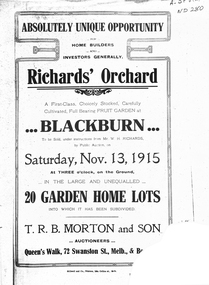
Legal record - Document, Richards' Orchard, 1/11/1915 12:00:00 AM
Estate Agent's advertisement for Richard's Orchard,Estate Agent's advertisement for Richard's Orchard, Main Street, BlackburnEstate Agent's advertisement for Richard's Orchard,richards orchard blackburn, main street, blackburn, land subdivision, t. r. b. morton & son -
 Whitehorse Historical Society Inc.
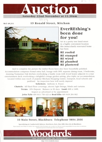
Document, 19 Ronald Street, 1997
Real Estate agent's advertisementReal Estate agent's advertisement for No 19 Ronald Street, Mitcham.Real Estate agent's advertisement ronald street, mitcham, no 19 -
 Whitehorse Historical Society Inc.
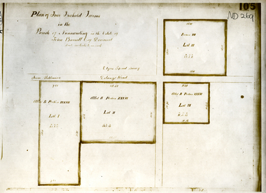
Document, Parish of Nunawading
Plan of four farms in the estate of John BarrattPlan of four farms in the estate of John Barratt on Delaneys RoadPlan of four farms in the estate of John Barratt parish of nunawading, barratt, john, delaney's road, ringwood north, elgars special survey, land subdivision -
Whitehorse Historical Society Inc.
Map, Map Of The Entire City Of Nunawading, 1920s?
City of Nunawading published by Frank Fisher & Co. Estate Agents.City of Nunawading published by Frank Fisher & Co. Estate Agents.City of Nunawading published by Frank Fisher & Co. Estate Agents.city of nunawading, maps -
 Whitehorse Historical Society Inc.
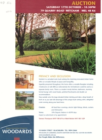
Document, Auction, 1/10/1998 12:00:00 AM
Estate agent leafletEstate agent leaflet for auction at 79 Quarry Road, Mitcham.Estate agent leaflet r. g. woodard pty ltd, auctions, quarry road, mitcham, no 79 -
 Stawell Historical Society Inc
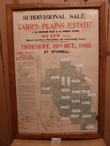
Memorabilia - Realia, 1905
Carr’s Plains Estate Subdivision Sale Poster with Subdivision Mapstawell -
Stawell Historical Society Inc
Functional object - Bottle, 2018
Wine Bottle Grampians Estate Diamond House Heritage Restrauntstawell -
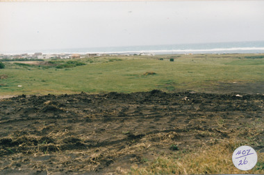
 Port Fairy Historical Society Museum and Archives
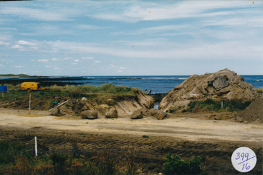
Photograph
South Beach DevelopmentColoured photograph of Drain being dug for South Beach Estatesouth beach, development, drain, sea, ocean, reef -
 Port Fairy Historical Society Museum and Archives
Photograph, Jock Varcoe
South Beach DevelopementColoured photograph of Grasslands and cypress trees - South Beach Estatecypress, trees, south beach, development -
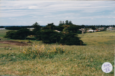
 Port Fairy Historical Society Museum and Archives
Photograph
South Beach Development Coloured photograph of Earthworks on hill with south beach estate in distance407/26 (since removed 2021)south beach, development -
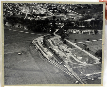 Orbost & District Historical Society
aerial photograph, 1970's
This photograph was taken prior to the closure of the Orbost -Bairnsdale freight line in 1987.The Orbost-Bairnsdale railway initially played a crucial role in developing agricultural industries in Gippsland as well as tourism. It opened in 1916 and operated until 1987, principally carrying timber and farming produce. In the early days of the railway's operation dedicated passenger trains ran but these ceased by the 1930s. The line was completely closed to freightage in 1987.The track infrastructure was dismantled in 1994 and has been redeveloped as the East Gippsland Rail Trail.A large black and white aerial photograph of Orbost Railway Station in the foreground and the Orbost township in the background. It has been pasted onto a piece of Masonite. railway photography orbost, railway photography orbost