Showing 13351 items matching "stations"
-
 Otway Districts Historical Society
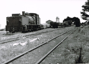
Photograph, R.L. Forster, G41 at Beech Forest, 1950, 1950
G41 engine and mixed goods carriages on the southern track nearest the Goods Shed, NQ trucks laden with timber next, an empty line, and further carriages next to the station building at Beech Forest in 1950. B/w.beech forest; colac; railways; -
 Otway Districts Historical Society
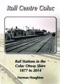
Book, Norman Houghton, Rail Centre Colac, 2014
Colac was the centre of a spidery rail network over which were carted anything and everything by Victorian Railways, the common carrier throughout the area. The main line through the region was the 35 km rail route from Birregurra (and thence to Geelong) though Colac to Pirron Yallock (and thence to Warrnambool and Port Fairy) from March, 1877, to July, 1883. The first branch line ran from Irrewarra to Beeac in 1889, which then extended in stages to Cressy and on the Ballarat. The second branch line was the 31 km long Birregurra to Forrest in 1891. The cost of building railways into mountainous terrain meant the third branch line was a narrow-gauge 2 foot 6 inch line, first of all to Beech Forest in 1902, and then to Crowes in 1911, for a total of 71 km. The final rail connection was the 16 km branch from Colac to Alvie to facilitate the transport of onions, opening in 1923. Each line had its own character and peculiarities derived from its foundation, geography and economic base. As a general rule, the loadings on the branch lines had greater output tonnage than inwards, the reverse of the main line. The lines traversed agricultural and timber areas where inputs like seed, grass, fertiliser and labour were minor, compared with the output, timber, wool, cream, butter, cheese fruit, potatoes, onion, grain and livestock.Rail Centre Colac. Rail stations in the Colac Otway Shire, 1877 to 2014. Norman Houghton. 1st ed. Norman Houghton; Geelong (Vic); 2014. vi, 262 p.; illus., maps, index. Soft cover.colac; cressy; forrest; beech forest; crowes -
 Ballarat Tramway Museum
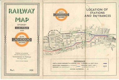
Map, NSWGR, "Railway Map of Sydney Suburban and Underground" - 1939, 1939
Light card or Heavy paper. Colour map showing location of Sydney stations and entrances and where the trains ran. Issued as No.1. Title "Railway Map of Sydney Suburban and Underground" - 1939. Handle with care - both copies.trams, tramways, sydney, railway map, suburban and underground, trams -
 Buninyong & District Historical Society
Photograph - B/W photograph, Clive Brooks, Warden's Office, Butter Factory, Cornish St. Buninyong, north side, 18 July 1993
1850's Gold Rush Police Precinct, later adapted for industrial use, and then used as Council Depot.B/W photo, north wall of Butter Factory (c1890), sandstone rear wall of Warden's Office (c1859) visisble to right. Cornish St. Buninyong near Yuille St. Old Police Station/Residence behind.buninyong, warden's office, butter factory, depot, couthouse, police -
 Williamstown Botanic Gardens- Hobsons Bay City Council
Postcard - Williamstown Botanic Gardens, c1900-1920
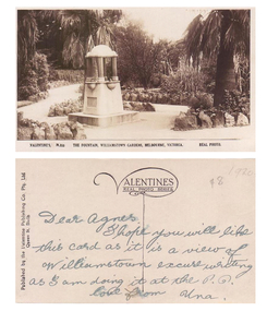
The original postcards in this series (2013.002 to 2013.018) were generously loaned to Williamstown Botanic Gardens by a private collector for copying. The fountain is located on the southern side of the ornamental lake and was erected to celebrate the jubilee of the municipality (17 March 1906). Controversy surrounded the commission for the design and construction of the fountain, as it was originally assigned to a contractor in Carlton. Williamstown residents insisted the fountain be designed and constructed locally, and on December 1906 the fountain was tendered by local firm Bliss and Sons and opened for public use in 1906. The fountain features a symmetrical plan, consisting of fur granite columns supporting a granite canopy and is fully operational following restoration work in 2013. The idea for the fountain came from an elderly resident of Williamstown who suggested the council follow the example of Ballarat’s gardens with its many statues and monuments. The postcards are evidence of the interest the gardens held as a subject for postcard publishers. The text and images provide a snapshot into fashions, social interests and concerns of the time. The professionally produced images provide a pictorial history of Gardens including changing planting styles, various structures and features of the Gardens eg the aviary, cannons, the fountain, the second Curator’s Lodge and gates. The images offer an opportunity to compare garden vistas with the present day. The significance of the fountain is its reflection of how Williamstown people felt for their Gardens and the importance placed on investing in locally operated business. It was noted in the Brief Jottings column of the Williamstown Chronicle, February 24 1906, the fountain is a “We favor the erection of the jubilee fountain in the Giffard-street (Williamstown Botanic) Gardens. Ornaments of that kind there will make that beauty spot even more attractive.” Sepia scene of a fountain situated on paths bordered with rocks. The fountain in on a plinth and the postcard shows the plaque and two of the four drinking stations. The fountain features a symmetrical plan, consisting of four granite columns supporting a granite canopy. Front: VALENTINE’S, M.355 THE FOUNTAIN, WILLIAMSTOWN GARDENS MELBOURNE, VICTORIA. REAL PHOTO. Reverse: vertical on left side of card and underlined: ‘Published by the Valentine & Sons Publishing Co. Ltd. / Queen St, Melb’. Top centre of card: Contains logo of ‘VALENTINES / REAL PHOTO SERIES’. The postcard is addressed to ‘Dear Agnes’ from ‘Una’. Marked in pencil on to right hand corner ‘1920 / $8’ believed to be put on the postcard by the vendor. postcard, gardens, post-card, williamstown-botanic-gardens, hobsons-bay-city-council, jubilee-fountain, fountain drinking-fountain, 1920, granite, bliss-and-sons, 1906 -
 Surrey Hills Historical Society Collection
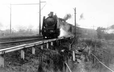
Photograph, Loco K176 at Surrey Hills on a vintage tour train to Healesville, 1 October 1966, 1 October 1966
We have an original B&W copy donated by Ian Barkla and a larger one copied by Ken Hall. The Barkla original has a sticker with his reference details on the back. The photo records a Vintage Train tour to Healesville on 1 October 1966. The Lilydale to Healesville line opened on 1 March 1889. The last steam train on the line ran in 1957 and the last passenger service was in 1980. The line reopened as a tourist railway in 2010. Although the photo was taken on a misty day, houses in Windsor Crescent can just be seen in the background. It is possibly Lorne Parade in the background with preparatory works for the 3rd rail line underway.A black and white photocopy of a steam train. One person is looking on from the left hand side of the photo. It's a misty day but houses in Windsor Crescent and the pedestrian overpass at Surrey Hills railway station can be seen.surrey hills railway station, windsor cresent, 1966, railfan tour, steam trains, vintage tour train -
 Port Melbourne Historical & Preservation Society
Plan - Area bounded by Nott Street, Graham Street, Esplanade West and Rouse Street, Port Melbourne, 29 Feb 1952
Plan showing properties in area bounded by Nott, Graham, Esplanade W. and Rouse Streets with plan showing properties in area bounded by Station, Graham, Nott and Rouse Streets (House Common Orders) Also statistics of 1948.Top RH corner - reverse: notation - 'residential zoning amendment':Face: continuing notations (at least up to 1963):Lower, indication : 'Existing conditions 1948'built environment - commercial, built environment - civic, built environment - domestic, built environment - industrial, town planning, religion - roman catholic church (st josephs), swallow & ariell ltd, troedel & cooper pty ltd, wilsons sheet metals, franklin & anderson, g h westwood & sons, atlas plastics, w j carr, craven, robert timms, sunkist, tip top paints, knox schlapp pty ltd, daro plastics, triton construct, newmans, national bank, religion - wesleyan methodist church, court house, police station -
Lakes Entrance Historical Society
Book, Rennick, Joan, Sketched from Memory, 1982
A family history through the eyes of Joan Rennick (nee Hay), born 1903 in St. Kilda. School days at convent boarding school are described. Life in suburban Melbourne and at Boomanoomana station on the Murray are included. Illustrated with photographs,Best wishes from Joan and Liz.genealogy -
 Melbourne Tram Museum
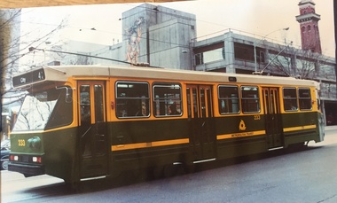
Photograph - Colour Print/s, The Met, mid 1980's
Large plasticised colour print of A class No. 233, when new, in Gisborne Street running a route 42, City with the MFESB Fire station No. 1 (Eastern Hill) in the background. Has Metropolitan Transit Logos on the side of the tram.trams, tramways, a class, gisborne st, city, fire station, tram 233 -
 Melbourne Tram Museum
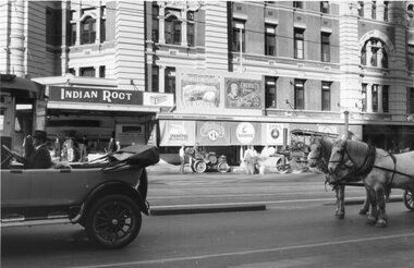
Photograph - Colour Photograph/s, Keith Kings, 27/02/2008 12:00:00 AM
Black and white photograph of Flinders St during the filming of The Pacific, 27/2/2008. Included within the photo is a street work gang with two rollers, horses, and Flinders St Station with a number of adverts placed on the verandah.Has Keith Kings stamp on the rear, but no number.trams, tramways, films, drivers, crews -
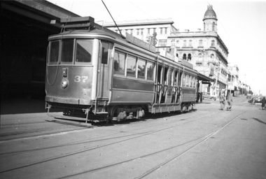 Melbourne Tram Museum
Negative, Wal Jack, 6/09/1936 12:00:00 AM
Black and white negative, of Victorian Railways tram 37 at St Kilda Railway Station, 6-9-1936. Has the George Hotel in the background. Photo in the Wal Jack Victorian Railways Album which provides the date.trams, tramways, victorian railways, vr trams, st kilda railway station, tram 37 -
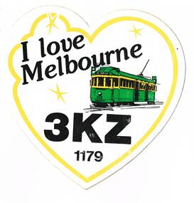 Melbourne Tram Museum
Ephemera - Bumper Stickers, Radio station 3KZ, "I love Melbourne", c1990
Bumper or car sticker, advertising Melbourne radio station 3KZ, 1179 on the dial featuring Melbourne W2 No. 515. Has been produced in the shape of a heart. On the rear are the "Application Hints". See also Reg item 1489trams, tramways, radio stations, 3kz, advertisements, melbourne, tram 515 -
Port Melbourne Historical & Preservation Society
Audio - PMHPS Meeting, Thirst-Aid Kiosk, Ted Rohan, Glen Stuart, 25 May 1998
Recording of PMHPS Meeting on 22.06.1998. Recording done by Glen Stuart at Port Town Hall. Speaker wasTed Rohan from the Thirst-Aid Kiosk, Station Pier (now demolished). Recording duration 1:07:35.piers and wharves - station pier, piers and wharves - waterside workers, transport - shipping, business and traders, edward j (ted) rohan, thirst-aid kiosk -
 Lakes Entrance Historical Society
Photograph - Foreshore Lakes Entrance, Lakes Entrance Tidy Town Committee
Also a colour photograph of toilet block at North end of footbridge taken from the car park on the Eastern side 04268.1 20 x 15cmColour photograph taken from the forecourt at the North end of the footbridge looking towards the service station on the corner of Myers Street and Esplanade Lakes Entrance Victoria. Also a second photo showing toilet block near the footbridgebridges, people -
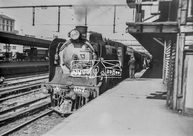 Eltham District Historical Society Inc
Photograph, George Coop, A2-class Steam Locomotive 987 at Spencer Street Railway Station, c. November 1962, 1962
Current Southern Cross Railway Station was originally Spencer Street Railway Station prior to upgrade and addition of wave form roof This photo was taken the same time as EDHS_05399 Diesel-electric rail cars in the Railmotor Yard on the other side of the platform at Spencer Street Railway Station.Digital TIFF file Scan of 35mm Ilford FP3 black and white transparencya2 class steam locomotive, a2-987, george coop collection, southern cross railway station, spencer street railway station -
 Wangaratta Urban Fire Brigade
photograph
.1: training - out the front of Ely st fire station .2: training - on roof af Ely st fire station .3: ???, Barrie sanders - spyaying fire hose of rear of Ely st fire station roof .4: training - gas bottle flare fire4 photographstraining, ely st -
 Lake Bolac & District Historical Society
Black and white photograph, Lake Boloke Station woolshed
The Lake Boloke Station bluestone woolshed is located 4 kilometres north of Lake Bolac on the Back Bolac Road. Originally the main woolshed for the station. It was built by Robert Patterson in the mid 1860's but later owned by the Wills Family, as 'Fintry', following the subdivision of Lake Boloke Station.Black and white photographlake boloke, woolshed, bluestone, wills family, patterson, fintry -
 Ballarat Tramway Museum
Photograph - Digital image Set of 6, George Coop, 1968 - 1970
Yields information about the tram operations at or near the Ballarat Railway Station.Six (6) Digital images taken by George Coop during the period 1968 - 1970, of SEC trams in Lydiard St North near or at the Railway station/ .1 - Tram 28 northbound with the station building and signal gantry in the background. No. 28 has a White Florist roof advert. .2 - Tram 32 southbound - taken from the signal box, has the gate wheel in the foreground. .3 - Tram 27 south bound, with destination of Sebastopol, with the station building, signal gantry and Reid's Coffee Palace in the background. No. 27 has a Twin Lakes sign and a Bliss Bombs roof advert. .4 - Tram 32, northbound, crossing the railway tracks, taken from the signal box has the railway station goods shed, building and signal gantry in the background. The tram has a Wilkinson Sword Razor blades roof advert. .5 - Tram 28, southbound from signal box. See image .1 for details. .6 - Tram 27, southbound in Lydiard St north with Bliss Bombs advert and destination of Sebastopol. Has the goods yard in the background. Taken through the verandah of Victoria House. trams, tramways, level crossings, railway station, lydiard st north, signals, tram 28, tram 32, tram 27 -
Port Melbourne Historical & Preservation Society
Pamphlet - Along the Vanishing Lagoon 1994, Pat Grainger, Walks around Vintage Port No.2, Nov 1994
Tourism pamphlet produced in time for the visit of the Replica Endeavour to Station Pier, Nov/Dec 1994. Print cost sponsored by Station Pier Condominiums.Port Melbourne Historical and Preservation Society publication, "Walks around Vintage Port", No.2 Along the Vanishing Lagoon, 1994 edition. sandridge lagoon -
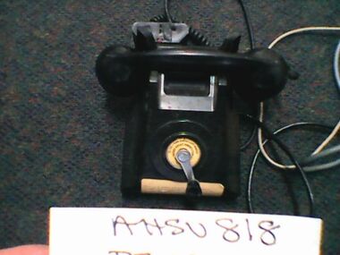 Ambulance Victoria Museum
Magneto Crank TelephoneTelephone, Early 20th centry
Probably from regional station or regional station officer's house for after hours call outs. Possibly from suburban station officer's house. Source Chas Martin AHSV curator. label on telephone states that this was a spare disaster plan (displan) magneto telephone. Other details on label.Black telephone with wind up handle in front centre. Batteries behindTO CALL TURN HANDLE & KIFT HANDSETcommunications, disaster -
 Bendigo Historical Society Inc.
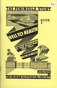
Book - STRAUCH COLLECTION: THE PENINSULA STORY BOOK 2
Victoria's first quarantine station was established at Hobson's Bay in 1840. However with the influx of immigrants during the gold rush, a new station was needed in Port Phillip Bay. In 1852 the "Ticonderago" arrived with 300 passengers ill with scarlet fever and typhus. They were landed at Point Nepean, Portsea, which which was known as the "Sanitary Station" until the 1880's when it's name changed to the Quarantine Station. It ceased quarantine duties in 1980.The Peninsula Story Book 2 Hell to Health the history of quarantine at Port Phillip Heads 1852 - 1966 by Major J.H.Welch, published by the Nepean Historical Society. Soft cover 96 pages with black and white photographs.Major J H Welchvictoria, history, quarantine station, australia-quarantine station-portsea vic-history-victoria -
 Bendigo Military Museum
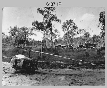
Photograph - Bell 47G-2 helicopter used in Royal Australian Survey Corps Field Operations, c1965
This is a set of four photographs of Bell 47G-2 helicopters used in Royal Australian Survey Corps Field Operations. c1965. From 1957, helicopter transport of survey parties revolutionised transport in remote areas. The most common helicopter used by the Royal Australian Survey Corps at this time was the civilian Bell 47G-2 and the Sioux, the Australian Army’s’s equivalent. equivalent. From 1964 an Aerodist MRC2 airborne Electronic Distance Measuring (EDM) system was extensively used for topographic surveys over long distances by trilateration to replace traverse requiring survey station intervisibility. In 1965 the command field survey unit personnel attached to the Army Survey Regiment’s Topographic Squadron were used mainly in support roles such as station clearing, tower operations, station monumenting, Aerodist computations, forward base operations, geodetic observations on the north-south traverse and logistic support for Remote teams. .1P is a photo of a civilian Bell 47G-2 helicopter Registration / Serial VH-UTB owned by Helicopter Utilities from Mascot, NSW c1965. In the background of this photograph is three personnel and vehicles at a field survey camp. The left-hand vehicle is a Willys Jeep with trailer and on the right is probably a Truck, 2 1/2 ton, 6x6, General Service GMC. The Bell 47G-2: VH-UTB was destroyed, and its pilot killed in tragic circumstances during a civilian survey operation on Cape York Peninsula in June 1966. .2P is a photo of a a civilian Bell 47G-2 helicopter Registration / Serial VH-IHB taken in Wyndham, WA. As the letters ‘TAA’ appear on the fuselage, the helicopter was charted from Trans Australian Airways. .3P is a photo of a Bell 47G-2: VH-UTC with survey camp in background. .4P is a photo of a Bell 47G-2 equipped with floats and unidentified personnel loading stores, possibly in Darwin. Acknowledgement: Royal Australian Survey Corps – Aerodist Years 1964-1975 Version 2021.0 Authored by Peter Jensen.This is a set of four photographs of civilian Bell 47G-2 helicopters used in Royal Australian Survey Corps Field Operations. c1965. The photographs were printed on photographic paper and are part of the Army Survey Regiment’s Collection. The photographs were scanned at 300 dpi. .1) - Photo, black & white, c1965, Bell 47G-2 helicopter: VH-UTB with survey camp in background. .2) - Photo, black & white, c1965, Bell 47G-2 helicopter: VH-IHB with survey station in foreground. .3) - Photo, black & white, c1965, Bell 47G-2 helicopter: VH-UTC with survey camp in background. .4) - Photo, black & white, c1965, Bell 47G-2 helicopter: Unidentified personnel loading stores possibly in Darwin..2P – annotated on bottom of photo ‘Wyndham Area – Helicopter drops observing party’ The other photographs are not annotated.royal australian survey corps, rasvy, army survey regiment, army svy regt, fortuna, asr, surveying -
 Ringwood and District Historical Society
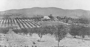
Photograph, View from Canterbury Road/Balfour Avenue area overlooking Martell's orchard, Heathmont, 1929
Black and white photograph of orchard. House in middle range, mountains in background. Photograph appears to be reproduced from subdivisional brochure. Note inserted in sleeve reads, "It has been pointed out that the mountains are to the east and the view is looking south. This therefore is not a 'straight' photograph. House still exists in Eden Avenue at October, 1996".(3 copies).Typed below photograph, "Panoramic view taken on the estate". "View overlooking Martell's orchard, Heathmont, 1929". Taken from corner Canterbury Rd. and Balfour Ave. looking south. Dandenong Creek just beyond house. Washusen Rd. on right". Written on back of one of the copies, "Heathmont Station Estate 1922". "Station Street, Lisgoold St. Canterbury Rd. Vivienne Cres. Balfour Ave." -
 Ringwood and District Historical Society
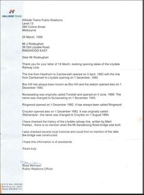
Document, V/Line and Hillside Trains Public Relations correspondence to Mr J. Rodaughan, Ringwood East, 1985 & 1999 - Lilydale Railway Line History
Letters from Victorian railway authorities containing information and publication extracts forwarded to Mr. J. Rodaughan, 26 Old Lilydale Road, Ringwood East in response to requests for information associated with Lilydale Railway Line history.The line from Hawthorn to Camberwell opened on 3 April, 1882, Camberwell to Lilydale opened on 1 December, 1882. Box Hill, Ringwood and Croydon stations opened on 1 December, 1882. Croydon was originally called Warrandyte station until the name was changed to Croydon on 1 August, 1884. Nunawading was originally called Tunstall and opened on 4 June, 1888. The name was changed to Nunawading on 1 November, 1945. -
 St Kilda Historical Society
Photograph, Tian Steuart
Photograph taken in 2009Colour photograph, mountedI took this photo because I think it represents Ripponlea. The photo shows all of the different things Ripponlea has to offer like beautiful parks with native plants and seating where you can see fascinating views. The station is a great part of Ripponlea because the station is old, interesting and it's good to travel from because it is never busy and it's always very clean. By Tian Steuartripponlea, ripponlea station, ripponlea state school -
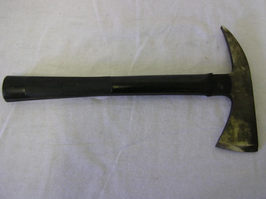 Ballarat Fire Brigade
Firemans axe
Axe was part of firemans belt was owned by Senior Firefighter (S/F) W.G. Jamieson who was stationed at Ballarat Fire Station as part of the permanent staff. firemans small personal axe (tomahawk), axe has black rubberised/plastic handle and metal headNo. 125 (right side of handle), TESTED 20,000 VOLTS (left side of handle), W.GILPIN (stamped into left side of head)w g jamieson, ballarat fire station, firemans axe -
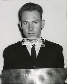 Eltham District Historical Society Inc
Photograph, Constable Lewis Howard, Victoria Police, 1965, 1965
Includes copy of Record of Conduct and Service Senior Constable Howard was stationed at Eltham Police Station from 9 Aug. 1972-7 Jun. 1976 Digital file only - scanned by EDHS from item on loanlew howard collection, lewis howard, service record, victoria police -
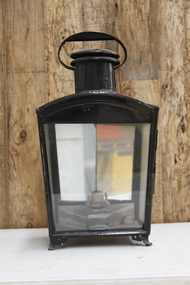 Puffing Billy Railway
Platform Kerosene Lamp, 1900s
Platform Lamp - Kerosene Platform Lamp Station Lamp When Made - 1900s Typical of the lights that lit a lonely railway station in the days before electricity.Historic - Early Railway Platform Kerosene LampLarge Kerosene Platform Lamp made of tin, brass and glasslamp, puffing billy, station lamp -
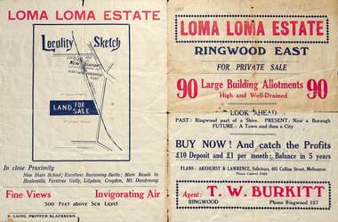 Ringwood and District Historical Society
Flyer, Land Sale Brochure, Loma Loma Estate, Ringwood East, Vic. - circa 1924
Flyer includes extract from "The Sun" 30/10/1924. "Ringwood has been created a Borough with capital value of £680,000. In 1908 there were 173 houses, 8 shops and 720 people. In 1918 the respective figures were 520, 45 and 2,080. For twelve months ended June, 1924, £51,000 worth of Home Sites were sold and £26,000 worth of new buildings were erected. Outward (train) passenger journeys have increased from 94,000 in 1919 to 182,000 in 1923. Train services have been almost doubled and time to Melbourne reduced from 60 to 37 minutes."Bi-fold double-sided land sale advertisement for Loma Loma Estate, Ringwood East, including area map, layout of the estate, and summary of local facilities and services.Subdivision includes Loma Street, Highton Street, Morinda Street, and Station Street (later Railway Avenue) Ringwood East. Agent: T.W. Burkitt, Ringwood, Phone Ringwood 157. -
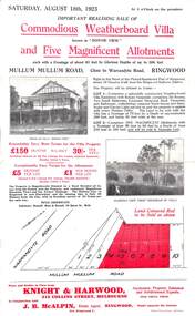 Ringwood and District Historical Society
Flyer, Advertisement for Mullum Mullum Road, Ringwood, Vic., Sale of "Bonnie View" Villa and five allotments. - 1923
Single page flyer advertising realising sale of villa and land in Mullum Mullum Road, Ringwood, at 3 o'clock on Saturday, August 18th, 1923. Also includes descriptions and photographs of the property, location of the blocks, and summary of local train services.Auctioneer - Knight & Harwood, 315 Collins Street, Melbourne, Tel 10615, 10616, in conjunction with local agent - J.B. McAlpin, Opposite Railway Station, Ringwood, Tel. Ringwood 7.