Showing 388 items
matching bluestone building
-
 Federation University Historical Collection
Photograph - Photograph Album, Photographs of Ballarat Buildings, 1967, 1967
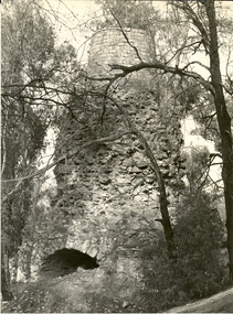
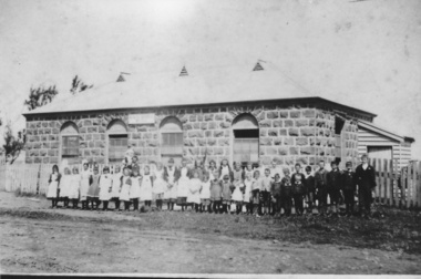
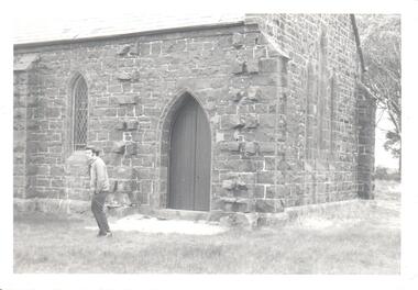
... .(Melbourne Advocate, 02 March 1939) ballarat buildings bluestone iron ...When these photos were taken Geoffrey Biddington was highly involved with the Ballarat Branch of the National Trust. At one time Her Majesty's Theatre was known as the Memorial Theatre. Lenaghan of Tourello "Master Dan Lenaghan, eldest son of Mr. and Mrs. R. Lenaghan, of Tourello, has been successful in obtaining a Government scholarship, tenable for four years at St. Patrick's College, Ballarat.(Melbourne Advocate, 02 March 1939) Two Black folders of Ballarat photographs as follows: .1) Interior of Ballarat Railway Station .2) Interior of Ballarat Railway Station .3) Craig's Hotel .4) Craig's Hotel .5) Craig's Hotel .6) Craig's Hotel .7) Ballarat Fine Art Gallery later Art Gallery of Ballarat .8) Cuthberts, corner Lydiard and Mair Streets .9) Golden City Hotel (GCs) .10) Golden City Hotel (GCs) .11) Reid's Coffee Palace .12) Alexandria Tea Rooms, neighbouring Old Colonists' Club, Ballarat, Lydiard Street North .13) ? .14 Caste iron drink fountain, corner of Strurt and Drummond Streets, October 1967 .15) Lal Lal Blast Furnace .16) Ballarat Botanical Garden Gates .17) Ballaarat Old Cemetery Gates .18) Novar gate .19) Ballaarat Old Cemetery Gates .20) ? .21) Webster Street .22) Doveton Street South .23) ? .24) ? .25) .26) .27) Iron hitching Rail .28) Iron hitching Rail .30) Postal Box, Corner or Armstrong Street South and Eyre Street, October 1967 .31) Iron Drinking Fountain in the Ballarat Botanical Gardens .32) Iron Drinking Fountain in the Ballarat Botanical Gardens .33) Killarney, Warrenheip .34) Killarney, Warrenheip .35) Killarney, Warrenheip .36) Killarney, Warrenheip .37) Bailey's Mansion, Drummond Street .38) Bailey's Mansion, Drummond Street .39) Beaufort House .40) Beaufort House .41) ? .42) ? .43) ? .44) ? .45) ? .46) ? .47) ? .48) Lenaghan's Tourello, February 1968 .49) Lenaghan's Tourello, February 1968 .50) ? .51) ? .52) ? .53) ? .54) ? .55) ? .56) ? .57) ? .58) ? .59) ? .70) Her Majesty's Theatre, Lydiard Street .71) Her Majesty's Theatre, Lydiard Street .72) Dana Street Primary School, September 1967 .73) Ballarat School of Mines Administration Building, September 1967 .74) Eureka Street Primary School ? .75) Selkirk Brick Chimney? .76) Grigsby's Foundry, Mair Street, September 1967 .77) Pratt's Warehouse, Camp Street .78) Premises of R. And R.A. Williams, Mair Street, September 1967 .79) City Oval Grandstand, with fire training tower in the background, .80) City Oval Grandstand .81) City Oval Grandstand .82) Smythesdale Post Office, October 1967 .83) Court House Hotel. Smythesdale, October 1967 .84) Smythesdale, October 1967ballarat, buildings, bluestone, iron, architecture, biddington, geoff biddington, railway, old colonists, lal lal blast furnace, beaufort house, her majesty's theatre, craig's hotel, botanical gardens, bailey, cuthbert, lenaghan, tourello, smythesdale post office, court house hotel, smythesdale, smythesdale, alexandria tea rooms, cast iron, eureka street primary school, dana street primary school, ballarat school of mines administration building, grigsby brass founder, foundry, pratt's warehouse, selkirk bricks, grandstand, court house hotel -
 Federation University Historical Collection
Photograph - black and white, Golden Point State School No. 1493
The Golden Point school building was started in 1874 and opened on 11 January 1875. Photograph of a brick building with slate roof and bluestone foundations at Golden Point, Ballarat.Below photo 'State School No. , Ballaarat, Golden Pt. Richards Photo, Ballarat - Education Dep. Vict.'golden point, education, school -
 Federation University Historical Collection
Book, New York Post, The School of Mine Quarterly: A Journal of Applied Science, 1889-1809
The School of Mines Quarterly was a jpournal of Applied Science from Columbia College, New York City.The Index to the School of Mines Quarterlu Volumes X1-XX (1900) and 32 green covered journals school of mines, new york, columbia college, schools of mines, columbia school of mines, witwatersrand goldfield, inter-continental railway, mine ropes, harbor improvememnts on the pacific coast, glycerine and artificial butter industry, transit factors for teh columbia college observatory, tables for the reducation of transit observations, ancienct methods for dividing and recoording time in japan, assay of tin, john strong newberry, standards of linnear measure, comparison of costs of electric lighting, huanchaca mine bolivia, el callao gold mine venezuela, john magnus adams, ores in saxony, hartz and rhenish prussia, hofmann apparatus, adjustment of trangulation, determination of carbonic acid in white lead, lower coals in western clearfield county pennsylvania, old telegraph mine ningham canon utah, mechanical preparation of ores, modern waterworks construction, curdling of milk, french regenerative gas furnace, irrication canals, peruvian salt mine, collection of metallurgic dust and fume, permeability of iron and steel, assay of silver, explosion in a zinc fume condenser, teaching archtectural history, liquid air, between the mine and the smelter, ballistic galvonometer, assay of telluride ores, analytical chemistry, theory and design of the masonry arch, silver pick mine wilson colorado, telegraphy and telephoney, mineralogy, morse code, michigan mining practices, titaniferous magnetites, paradox of the pantheon, rocks from wyoming, witwatersrand goldfields, gaseous sun, alternating current distribution, engineering tests on direct current electrical machinery, thomas egleston, ore dressing, frederick morgan watson, camp bird gold mine and mills, magnetic properties of iron and steel, morphology of organic compounds, antimony, structure of the starch molecule, cerrillos hills new mexico, geology, rossie lead veins, practical electrochemistry, lines of graphic statics, anistic acid by the ozidation of anniseed oil, bromate method for antimony, john krom rees, trust company of america building, helion lamp, frederick arthur goetze, mine surveying, pine wood oils, malleable cast iron, electrolytic treatment of galena, turpentine and pine oils, bluestone, ashokan dam bluestone, road resistances, oxy-gas blowtorch, mine dumps, segregation of steel ingots, masonry dam formulas, putnam county magnetic belts, gases, continuity of education, hydraulic diagrams, standardistion of potassium permanganate, sewerage discharge into sea water, modern waterworks, true column formula, slags from lead furnaces, missouri river, tempreture of gases, rocks, architectural history, modern dome, oil machine, undulations in railway tracks, irrigation engineering, cleps-tachymeters, electrical engineering, new york shales, fan pump, sucrose, isaac newton, french school of anstronomers, electrolytic polarization, benjamin bowden lawrence, diamond drilling, new york ciy water front, engineering profession ethics -
 Flagstaff Hill Maritime Museum and Village
Document - Plans, Lighthouse Keeper's Quarters Warrnambool, 1858-1909
The set of seven 1858 plans shows proposed plans for the original Lighthouse Complex that was built on Middle Island in 1858-1859. The whole complex was then transferred to Flagstaff Hill in 1871. The plan, dated 1909, is for proposed additions and repairs to the Quarters at Flagstaff Hill. The plan 'Alterations and Additions' shows alternate plans for changes to the quarters at the Flagstaff Hill location. This plan has no date. The Complex comprised the Lighthouse, the Lighthouse Keepers’ Quarters, the Store (now called the Chart Room) and a Privy, which was not included in these plans. The Keeper’s bluestone Quarters was a cottage divided into two compartments, one for each keeper and his family. The bluestone Store was divided into three; a store, a workshop an oil store (or office). The Privy comprised of a small building also divided into two separate, back-to-back toilets, one for each Keeper and his family. The Flagstaff Hill Keeper's Quarters have had extensions and additions at various times, and these have also been removed at various other times. THE PLANS - *Dec. 1858 (12/58) ‘Lighthouse Keepers Quarters No.2 Warrnambool’ (2375.01)* Public Works Office Melbourne – Front and Back elevations, sections, and floor plan. The drawing shows timber walls. [The floor plan is the closest plan to the current building, however, the walls are timber in this plan.] *Nov. 1858 – No.3 ‘Lighthouse Keepers Quarters Warrnambool’ (2375.02)* Office of Public Works, Melbourne – Back and End elevations and section through. The drawing shows stone walls. One side; Senior Keeper’s bedroom, living room and kitchen with storeroom. Another side; is the Assistant’s bedroom, living room and storeroom. *Nov. 1858 - No.4 ‘Lighthouse Stores Warrnambool’ (2375.03)* Office of Public Works – Front, Side and end elevations, centre section. The drawing shows stone walls. *Nov. 1858 – No.4, ‘Lighthouse Stores No. 2 Warrnambool’ (2375.04)* Office of Public Works – Front, side and end elevations, centre section. The drawing shows timber walls. *Nov. 1858 – ‘Details Lighthouse Keepers Quarters No. 2 Warrnambool’ (2375.05)* Public Works Office Melbourne. The plan shows the foundations, joists and eaves. The drawing shows timber walls. (Nov. 1858 – ‘No.4 ‘Lighthouse No. 2 – Warrnambool’ (2375.06)* Public Works Melbourne (Part of the paper is missing). This plan shows an octagonal tower, internal stairs, a balcony landing, and a weather vane on top. *November 1858 – No. 1, ‘Lighthouse – Warrnambool’ (2375.07)* Office of Public Works Melbourne. This plan shows a round tower, including the stairs, windows on the tower and the weather vane on the top. *4/3/9 [1909] – ‘Additions and Repairs, Lighthouse Quarters, Warrnambool, General Plan’ (2375.8)* Department of Public Works Melbourne’s official stamp is signed by Croft. It shows the floor plans of the Store, Upper Lighthouse and the Quarters. The Store building has three sections; a Store, Work-Shop and Office, with an internal wall between them and separate entries. The Quarters are divided into two dwellings. The Senior Keeper’s side on the left has fireplaces in two of the three bedrooms and there is a pantry and wash house. The Assistant’s side has no fireplaces in the bedrooms and there’s no pantry or washhouse. These plans include proposed changes to the buildings. The Senior Keeper’s Quarters would have a partition on bedroom 2, a bath with plumbing and drainage, a wall moved and a built-in side porch. The Store would also have a built-in porch. The undated plan 'Additions and Alterations' (2375.9) shows alternative arrangements for water tanks, plumbing and such. WARRNAMBOOL'S LADY BAY LIGHTHOUSES- In the 1800s ships sailing from England to Australia began to use Bass Strait as a faster route to Melbourne. Small navigation errors led to many tragic shipwrecks. From 1848 lighthouses were operating along Victoria’s southern coast as a guide for sailors. Coastal towns such as Warrnambool grew and the exchange of trade and passengers were of great benefit. However, the uncertain weather changes, relatively shallow waters and treacherous, hidden rocky reefs were not suitable for a Harbour and in the 1840s and 1850s there were many shipwrecks in the area, with some even stranded in its Lady Bay harbour. A jetty was built in 1850 and a flagstaff to guide seafarers was placed up high on what became known now as Flagstaff Hill. In November 1857 the Victorian Government recommended that Warrnambool Harbour had beacons and two lighthouses to guide vessels into and out of the Harbour safely. The white light of the Middle Island lighthouse was to be used for the first time on September 1, 1859. The red light of the Beach Lighthouse, a wooden obelisk structure, was first operated on March 25, 1860, but in 1868 this light was ‘discontinued’ due to it being too low. Melbourne’s Department of Public Works decided to relocate the Middle Island Lighthouse Complex - Lighthouse, Keeper’s Quarters, Privy, Store Room and even water tanks - to Flagstaff Hill. The lower obelisk was shortened, and a protruding gallery, railing, and external ladder were added, as well as the light from the Beach Lighthouse. A green guiding light was erected on the end of the jetty. The transfer of the Complex began in March 1871. Each shaped stone of the lighthouse was carefully numbered, removed then reassembled on Flagstaff Hill. In 1872 the well was sunk behind the Lighthouse Keeper’s Cottage. The Keepers and families had left Middle Island in April and moved to Flagstaff Hill in October 1871. Vessels entering Lady Bay align the Upper and Lower Lighthouse towers during the day and the lights at night. The Upper Lighthouse is a round tower, the Lower Light is square. The Lighthouses were categorised as harbour lights rather than coastal lights, so they remain under the control of the Victorian Government’s Ports and Harbours section. The lights were originally powered by oil, then acetylene gas, later by electricity, and then converted to solar power in 1988. In 1993 the solar panel was replaced by a battery charger. A decision was made in 1936 to replace the lighthouses’ lights with unattended lights that no longer required Keepers and Assistants. At least 29 Keepers had attended to the lighthouse from its opening in 1859 to when the last official Lightkeepers left In April 1916. The Warrnambool Harbour Board rented out the Quarters from 1916 to 1936. The Board closed down but the rentals continued with other unknown landlords. In the 1970s the Flagstaff Hill Planning Board was set up under the chairmanship of John Lindsay. The Board was to make recommendations to the Warrnambool City Council regarding the use of the buildings and the rest of the Crown Land on the site. The Flagstaff Hill Maritime Village opened in 1975 and began renovating the Cottage in stages, during which time evidence of a 1920s fire was found in the eastern section of the cottage. Additions of a porch on the west and a washroom on the east were made in the 1980s. The western part of the building is now a Shipwreck Museum and the east has returned to a late 19th-century Lighthouse Keeper’s cottage and includes the screen made by Assistant Lighthouse Keeper Thomas Hope during one of his two periods of service there. THE LIGHTHOUSE KEEPERS Lighthouse Keepers were responsible for keeping their Lighthouse’s lights shining at night. They kept a lookout for passing vessels and changes in weather. They were expected to clean, polish and maintain the equipment and buildings. They kept regular and detailed records of who was on watch, and the time the light was lit, trimmed and extinguished. They kept a journal about other events that occurred. They keep regular, accurate Meteorological Logs. It was expected that they were competent in Morse code signalling. They would be called to help in times of disasters and shipwrecks, and to give official statements about these events. Many Lighthouse Keepers also volunteered as members of the lifeboat crew. The Lady Bay lighthouses were officially classified as small, so the Keepers had the official titles of Senior Assistant Lighthouse Keeper and Assistant Lighthouse Keeper. They were employed by the Public Service and paid rent to live in the Lighthouse Quarters. They were compulsorily retired at the age of 60, with most receiving a superannuation payment. Despite their time-consuming duties, there was time to follow hobbies and crafts such as growing vegetables, playing musical instruments, making models of buildings including lighthouses, and crafting furniture pieces. An example of a keeper’s skills is the carved fire screen made by /assistant Keeper Thomas Hope in the early 20th century and displayed in the Lighthouse Keeper’s cottage at Flagstaff Hill. The last occupants of the Middle Island Complex were Senior Keeper Robert Deverell, his Assistant Keeper, Andrew Farncombe, and their families. They all became the first occupants at the Lady Bay Lighthouse Keepers’ Quarters on Merri Street. The Warrnambool Lighthouse Complex plans are the origin of what is now the Lady Bay Lighthouse Complex. They are a record of the people, process and departments involved in bringing the complex into fruition. The plans are significant to the Complex, which is now listed on the Victorian Heritage Register, H1520, for being of historical, scientific (technological) and architectural significance to the State of Victoria. The Complex is significant as an example of early colonial development. The plan are significant for their connection with the important navigational function of the Lighthouses, a function still being performed to this day. The plans are also significant as an example of a product from the Public Works Department in Victoria in the mid-to-late 19th century. The structures built to these plans still stand strong. Plans for the Lighthouse Complex in Warrnambool, including Lighthouses, Keeper's Quarters and Stores. Seven of the plans are on thin fragile paper, one is on thicker, stronger paper. The drawings have been made in pens coloured red and black. They originate from Public Works in Melbourne. Seven were drawn in 1858, one in 1904, the other is not dated.Dec. 1858 - Lighthouse Keepers Quarters No.2 Warrnambool. Public Works Office Melbourne. Nov. 1858 - No.3 ‘Lighthouse Keepers Quarters Warrnambool. Public Works Office Melbourne. Nov. 1858 - No.4 ‘Lighthouse Stores Warrnambool. Office of Public Works. Nov. 1858 - No.4, ‘Lighthouse Stores No. 2 Warrnambool. Office of Public Works. Nov. 1858 - Details Lighthouse Keepers Quarters No. 2 Warrnambool. Public Works Office Melbourne. Nov. 1858 - No.4 ‘Lighthouse No. 2 – Warrnambool. Public Works Melbourne. Nov. 1858 - No. 1, Lighthouse - Warrnambool. Office of Public Works Melbourne. 4/3/9 [1909] - Additions and Repairs, Lighthouse Quarters, Warrnambool, General Plan. Department of Public Works Melbourne. SIGNED "Croft" "15A" on reverse [no date] - Lighthouse Quarters Warrnambool, Additions and Alterations. "9A" on reverseflagstaff hill, warrnambool, lighthouse keeper's cottage, lighthouse residence, lighthouse, plans, public works, melbourne, flagstaff hill maritime museum, maritime museum, shipwreck coast, flagstaff hill maritime village, chart room, quarters, privy, middle island, beach lighthouse, obelisk, lighthouse keeper, assistant keeper, lighthouse complex, lady bay, lady bay complex, keepers, upper lighthouse, lower lighthouse, ports and harbours, cottage, harbour board, flagstaff hill planning board, meteorological record, robert deverell, andrew farncombe, warrnambool port, warrnambool harbour, residence, alterations, repairs, department of works -
 Flagstaff Hill Maritime Museum and Village
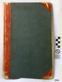
Financial record - Record Book, Warrnambool Lighthouse Book, ca. 1870s
Referencing works and removal of fittings and furnishings. Further on the book appears to have been used as a note book on further pages. WARRNAMBOOL'S LADY BAY LIGHTHOUSE COMPLEX; – The original Lady Bay Lighthouse Complex was built on Middle Island in 1858-1859 and comprised the Upper Light, Store (Chartroom), Cottage and Privy. The Lower Light was on a wooden tower on the beach of Lady Bay. In 1871 the Complex was transferred stone-by-stone to Flagstaff Hill, where the flagstaff had been installed since 1853. The Lower Light was erected on top of a bluestone obelisk that was built in 1854 as a navigational marker. The bluestone Lighthouse Keeper’s Quarters was a cottage divided into two compartments, one for the Senior Keeper and his family, the other for the Assistant Keeper and his family. The bluestone Store was divided into three; a store, a workshop, and an oil store (or office). The Privy was a small building divided into two separate, back-to-back toilet rooms, one for the Senior Keeper and his family and one for the Assistant Keeper and family. The record book from the Warrnambool Lighthouse is significant because of its connection with the Lady Bay Lighthouse Complex. The Lady Bay Lighthouse Complex is significant for its important role in the safe navigation of sailing and steam ships into and out of Lady Bay and the Port of Warrnambool. during the colonisation of Victoria and the settlement of southwest Victoria. The lighthouse also helped the passing ships to check the accuracy of their navigation along the southwest coast of Victoria and facilitated the call for help when vessels were in trouble.Warrnambool Lighthouse Book. Green hard covered book with red spine and reinforced corners. Inside are pages with printed horizontal linesBook detailing the cost of removal of the Lighthouse Station from Middle Island to its present location. Also other details. flagstaff hill, warrnambool, shipwrecked-coast, flagstaff-hill, flagstaff-hill-maritime-museum, maritime-museum, shipwreck-coast, flagstaff-hill-maritime-village, warrnambool lighthouse book, record of lighthouse relocation warrnambool, warrnambool historic record book, financial record, middle island -
 Federation University Historical Collection
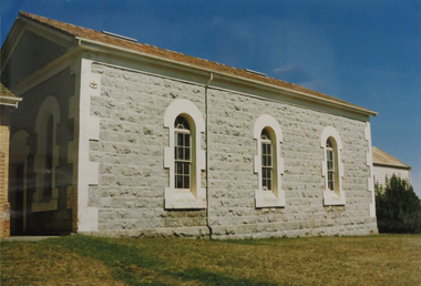
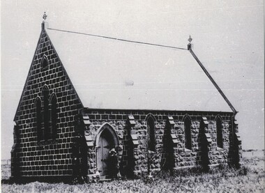
Photograph - Photograph - Colour, Mount Pleasant Wesleyan Chapel,1989, 27/02/1989
"Cornish immigration in Ballarat tended to group together as they did in Cornish communities around Victoria. The area known as Cornishtown in Ballarat in the 1850s was settled by quiet, religions Cornish Diggers who named the rise on which they pitched their tents, Pleasant Mont. This soon became known as Mount Pleasant, and the locality continued to attract cornish immigrants who built their homes around the Wesleyan Church. This had begun as a small tent chapel where the cornish diggers could worship in the peaceful quiet offered by the mont. As compatriots continued to expand their community, a larger and more subsyantial edifice was required. This plain box like building reflected its Cornish origins in its unpretentious appearance. This building still stands in the shadow of a more recent stucture." (Ballarat's Irish Folk by Ann Colman) Samson Keast and Elizabeth Jane Forror Pascoe married at this church on Christmas day 1865. Colour photograph of a bluestone church with three arched windows down one side.mount pleasant, mount pleasant wesleyan church, pleasant mont, samson keast, elizabeth pascoe, cornish, mt pleasant -
 Federation University Historical Collection
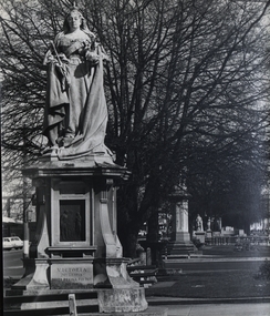
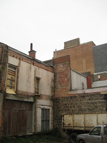
Photograph - Photographs, Geoff Biddington, Ballarat Photographs, 1967, 1967
Black and white photographs of Ballarat buildings .1) Spiral Staircase .2) Union Hotel, Ballarat .3) Queen Victoria statue, Sturt Street .4) St Patrick's Cathedral gates .5) Shingle roof in Ballarat .6) Bluestone laneway .7) St Alipius', Ballarat East geoff biddington, ballarat, union hotel ballarat, queen victoria statue, shingle roof, blustone laneway -
 Bendigo Historical Society Inc.
Photograph - UNKNOWN FAMILY COLLECTION: PHOTOGRAPH
Photograph - black and white. Tram tracks being laid. Also bluestone blocks are used. On back on photo is the word 'Long Gully ?'. Park on left of photo then a building in middle of photo says 'A.Cornwell, Baker'.W.H. Robinson, Mundy Street, Bendigo.place, transport, tram, tram tracks. long gully. -
 Bendigo Historical Society Inc.
Photograph - BENDIGO HISTORICAL SOCIETY COLLECTION: RUINS OF MIA MIA HOTEL
Colour photograph of bluestone ruins of former Mia Mia Hotel, Mia Mia. Part of one wall standing with window opening. Bare trees in background and on side. Burke and Wills Expedition travelled through this region and allegedly visited the Mia Mia Hotel. The Burke and Wills expedition passed through Mia Mia in 1860 on their journey across Australia from Melbourne to the Gulf of Carpentaria. They arrived on Saturday, 25 August 1860 and made Camp VI at Mia Mia.buildings, commercial, mia mia hotel -
 Port Melbourne Historical & Preservation Society
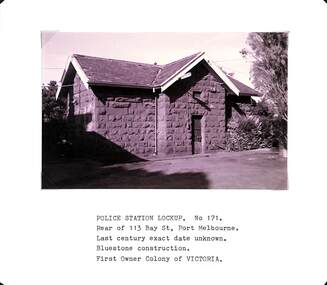
Photograph - Police Station lockup, rear of 113 Bay Street, Port Melbourne, Arthur Rowan, 1985
As a member of the Port Melbourne Historical and Preservation Society, donor Arthur ROWAN photographed a series of significant buildings in the Port and South Melbourne area over several years. A selection of nineteen of these was presented to the Port Melbourne Society in 1993.Small print mounted on white card, with mounted, typed caption: Police Station Lockup, rear of 113 Bay Street Last century date unknown [1860s] Bluestone construction. First owner: Colony of Victoria.built environment - civic, arthur rowan -
 Port Melbourne Historical & Preservation Society
Photograph - NOT FOR SALE sign on the roof of Olive Zakharov's house, Little Swallow Street, Port Melbourne, 1990
One of several Alison Kelly photos of Olive's house showing the 'Not for Sale' sign. Laserprint of photo of Senator Olive Zakharov's house in Little Swallow Street, portion of bluestone lane showing, and NOT FOR SALE sign on roof c1990. Home destined for compulsory acquisition by government to make way for building of the Bayside project. Residents' battle won; house still stands, hidden amongst Beacon Cove homes. Sen. Zakharov died in 1995 after being hit by a car in St Kilda Roadbuilt environment, public action campaigns, olive zakharov, politicians, senators -
 Bendigo Historical Society Inc.
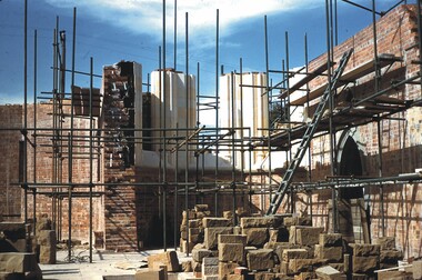
Slide - BENDIGO BUILDINGS & CHURCHES, Mar 1960
Slide. Bendigo Buildings & Churches. Scaffolding in place at the church and bluestone pitchers stacked ready for use.slide, bendigo, bendigo buildings & churches., bendigo buildings & churches. -
 Bendigo Historical Society Inc.
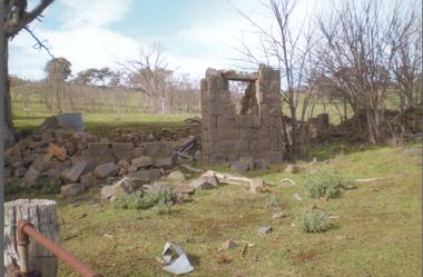
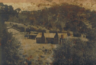
Photograph - THE SPRINGS, SEDGWICK
Photograph - black and white. Photograph of 'The Springs, Sedgwick', 14 miles from Bendigo. Rocky, hilly landscape with scattered trees, two chimneys on the main building in the centre, horse and rider approaching the building. Also 3 current photographs taken by Phillip Wilkin on July,2009. The 3 current photo's showing bluestone ruins - it is the same building on the left of the old photo - not the building with 2 chimney's, the one hidden behind trees (you only see part of it). Phillip's grandfather (Charles Wirth) moved here in 1901, along with his parents and grew up in that building (now ruined), the family still own the land.place, land, the springs, sedgewick., the springs, sedgwick. -
 Victorian Interpretive Projects Inc.
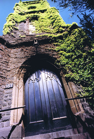
Photograph - Colour, Clare Gervasoni, St Alipius Presbytery, Ballarat East, 07/01/2012
St Alipius Church was the first Catholic Church at Ballarat. It was initially a tent church in Humffray Street, but after flooding it was moved to Victoria Street were the current bluestone church was built. The presbytery is beside the church and houses the priests. A colour photograph in digital format showing red brick building with slate roof, behind a green iron fence. The building is St Alipius Presbytery, Victoria Street, Ballarat East. ballarat east, catholic, religion, church, st alipius', st alipius -
 Victorian Interpretive Projects Inc.
Photograph - Colour, Clare Gervasoni, Yard at the end of Unicorn Lane, Ballarat, 2009, 20/06/09
These photographs were taken before the refurbishment of the Unicorn Hotel was completed (2012)Six digital colour photographs showing the yard at the end of Unicorn Lane, Ballarat in 2009. The Unicorn Hotel fronts Sturt Street, and Unicorn Lane runs beside it. Sides of buildings in the yard show bluestone and brick construction. ballarat, unicorn hotel, unicorn lane, bluestone, brick, yard, backyard -
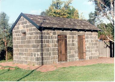
 Buninyong & District Historical Society
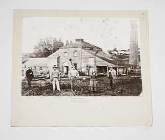
Photograph - B/W photograph, Buninyong Brewery c 1870, c1870
... Buninyong industry, original bluestone building. Buninyong Brewery ...Photograph of an early family, the Sheppards, by their early industrial building, the brewery, in Buninyong, c1870.Significant example of early Buninyong industry, original bluestone building.Mounted B/W photograph of Buninyong Brewery c1870. Bluestone block, brick and timber building with tall round brick chimney nearby. Sheppard family in front of brewery, depicted M,M,M,F,M, with good clothing detail.buninyong brewery, brewery, buninyong, industry, building -
 St Kilda Historical Society
Photograph
The bluestone 1857-58 former Wesleyan Church, on the corner of Fitzroy Street and Princes Street St Kilda, was one of the first Wesleyan churches in Victoria designed in the gothic style. It had a square central entrance tower and early English stepped buttresses and pinnacles above. It was later the St Kilda Uniting Church and was closed on 25 June 1978. It has now been covered to flats.According to Heritage Victoria: The old St Kilda Methodist Church is a finely designed 1850's church building and centrepiece of a group of individually significant buildings in an urban conservation area. Towered churches from the 1850s are rare in Melbourne and this building is thus of special significance in this regard as well as for its design and detailing. This building is an important work of architects Crouch & Wilson. Thomas Crouch was prominent in St Kilda Methodist church affairs and lived locally. He served a term as mayor of St Kilda and also designed the chapel at Pentridge and Methodist churches at Fitzroy, Collingwood, Flemington, Daylesford and Maldon. St Kilda was the home of many of the better off Melbournians in the 1850s, '60s and '70s. The adjacent former Sunday School is one of Melbourne's finest and the combination of fine church and hall side by side gives each added significance. https://vhd.heritagecouncil.vic.gov.au/places/1110churches, fitzroy street, st kilda, crouch, st kilda uniting church, st kilda wesleyan methodist church, princes street -
Winchelsea and District Historical Society
Photograph, Old wooden bridge and New Bluestone Bridge circa 1867
photograph taken circa 1867/8 Original wooden bridge built about 1857Photo of Blue stone bridge, as is today This photo is important, shows Winchelsea before many buildings.Very early Winchelsea circa 1867/8.photo taken from opposite old Library. Early wooden bridge right foreground and present bluestone bridge centre foreground. First Shire Hall and Dr. Meyler,s residence right above wooden bridge. On the left is Stirling's StoreOld wooden Bridge and New Bluestone Bridge circa 1867. Winchelsea Shire Hall top right (First Shire Hall).bridge, dr. meyler, stirling's store, first shire hall, wooden. -
 City of Ballarat
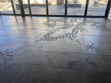
Artwork, other - Public Artwork, Diana Nikkelson, Goanna Ground by Diana Nikkelson, 2006
This is an Aboriginal artwork that depicts a Goanna Totem. Designed by Ballarat-based, Gunditjmara artist Aunty Diana Nikkelson, the design is inspired by the artist’s totem and is a tribute to the first artists of the region, the Wadawurrung people. It acknowledges Aboriginal survival and the dynamic regeneration of the Aboriginal art and culture in the region. The artwork is in-set to the basalt paving along Police Lane by a series of etched footsteps, which evolve from human footprints to goanna prints as viewers approach the rear of the Art Gallery of Ballarat. The artwork was originally located only outdoors and half of it was brought into the Art Gallery of Ballarat in 2011, when the former Federation Plaza was enclosed to form the Art Gallery of Ballarat's McCain Annexe. The artwork was created in 2006 as part of the cultural festival of the Commonwealth Games. The artwork is of cultural and aesthetic significance to the people of BallaratSand blasted petroglyph forms into bluestone on laneway surface. The carved inlay of the Goanna Totem design into the bluestone of Police Lane (beside Art Gallery of Ballarat) continues inside the building.goanna totem ballarat, goanna totem, diana nikkelson, aboriginal, dreaming, nikkelson, gunditjmara -
 Lake Bolac & District Historical Society
Photograph - Lake Bolac State School 1893, Lake Bolac State School No. 854
Application was made for a mixed school known as Parupa Common School in 1865. Building by Robert Pitkethley commenced in 1867. The name was changed to Lake Bolac State School No. 854 in 1870. The school was bluestone with galvanised iron roof. 30ft x 18ft x 10ft high with teacher residence attached. The building was used from 1867 to 1925 when it was sold for removal. Photograph shows Teacher William Bartlett and students in 1893. -
 Lake Bolac & District Historical Society
Black and white photograph, Scots Presbyterian Church Lake Bolac, circa 1890
Scots Presbyterian Church, Lake Bolac. The architect was Mr George Harriot and it was built of local bluestone by stonemason Mr Helme and completed in 1878. The Rev. Mr J S Muir took the opening service. Mrs John Moffat and Mrs William Veale laid the foundation stone. It was furnished by the existing Kauri pews but the present pulpit is not the original. Both Methodist and Anglican services were held in the building in the early years.scots presbyterian church, lake bolac, bluestone, methodist anglican, harriot, helme, muir, moffat, veale -
 Uniting Church Archives - Synod of Victoria
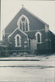
Photograph, undated
... of the building had caused the bluestone façade to bulge dangerously... in Church St. Richmond was laid in December 1868. The bluestone ...The memorial stone of the UMFC in Church St. Richmond was laid in December 1868. The bluestone church, which seated 308 people, was designed by G.R. Cox and built by John Wright. It was opened in May 1869. By 1890 subsidence in the foundations of the building had caused the bluestone façade to bulge dangerously outwards and a new façade of red and white brick was constructed. The memorial stone of the new façade was laid on 7th June 1890. Before construction of the 1868 church, services were held in a weatherboard building which subsequently served as the Sunday School.B & W photograph of the exterior of the Richmond United Free Methodist Church.united free methodist church, church street richmond, bluestone, g.r. cox, john wright. -
 Hume City Civic Collection
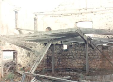
Photograph
Rosenthal Winery in Vineyard Road, Sunbury was one of the first wineries established in the area. It was owned by R. F. Kurrle. The roofless building still stands on the property which was part of the dairy farm owned by Tom and Angela Millett. The last vintage from the property was crushed in 1910.A coloured photograph of shell of the interior of the Rosenthal Winery. The bluestone is exposed on the lower half of the walls but the walls on the upper storey have either been rendered or painted. Part of the interior wooden structure is still standing. There is an open doorway on the LHS with two windows above it. Two smaller windows are on the lower part of another wall with a larger window above them. The building is roofless.rosenthal winery, wineries, vineyards, vineyard road, sunbury wineries, kurrle, r. f., millett, tom, angela, sunbury, george evans collection -
 Hume City Civic Collection
Photograph, pre 1970
... church bluestone buildings george evans collection A black ...The photograph of St Mary's Anglican Church at Bulla was taken before the completion of the airport at Tullamarine. Originally the church occupied a site on Oaklands Road near the Old Bulla Road. It was shifted to its present site in Bulla next to the old council chambers when the airport was built because the old site was near an important runway.A black and white photograph of a partial view of a bluestone church showing a rear and side view. There are three simple pointed arch windows across the restry and one on the side wall and a wooden door leading into the vestry.st mary's anglican church, bluestone buildings, george evans collection -
 Hume City Civic Collection
Photograph
The Aitken Gap Gaol was originally constructed at the Gap Settlement on the Calder Highway in 1857 for the gold escorts. It was relocated to its present site outside the Sunbury Police Station in Macedon Street between 1989 and 1991.A coloured photograph of the relocated Aitken Gap Gaol. It has bluestone walls and a moss covered slate roof. with 2 solid stained wooden doors and blue painted wooden trims. A small cell window is on the side of the building and a paved brick area surrounds the gaol.aitken gap gaol, gap village, sunbury police station, george evans collection -
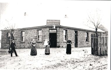 Hume City Civic Collection
Photograph
Photo copied from original in collection Sunbury & District Heritage AssociationB&W photo of a bluestone bulding, the Ball Court Hotel, Macedon Street, Sunbury with a male and three females, one holding baby, and a dog, standing in front of building. Unmountedhotels, cahill, john, cahill family, ford, justin, lupson, frederick, ball court hotel, george evans collection -
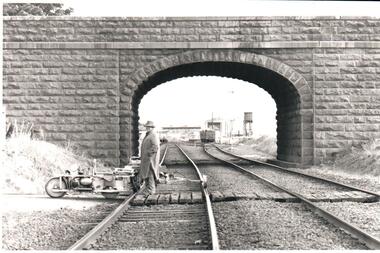 Hume City Civic Collection
Photograph, Pre 1989
The bluestone 'road over rail' bridge at Macedon Street is of state architectural, architectural, historical and engineering significance. It spans the first government regional railway. Its design and building was done according to strict English standards and made use of a bridge crossing instead of a level road crossing.A black and white photograph of a stone bridge with an eliptical arch spanning two rail tracks. A workman is standing between one set of tracks in the foreground and a railcart is next to the tracks. The station, footbridge and water tower are visible through the arch.road over rail bridge, bridges, sunbury railway station, water towers, pedestrian bridges, stone bridges, george evans collection -
 Nillumbik Shire Council
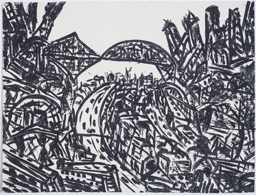
Print (sugarlift etching): Jan SENBERGS (b.1939 Lativia, arrived AUS 1950), Jan Sensbergs, 'New Jersey - rust belt' from the 'Baldessin & Friends' commemorative folio, 2016
Jan Senbergs was born in Riga, Latvia, in 1939 and came to Australia when he was ten. Senbergs’ work has been characterised by a simple and bold aesthetic. From lush landscapes to barren urban spaces, his body of work signifies an artist who has continually experimented with shape, form and motif, a fundamental humanist vision, a finely-honed sense of the absurd, and a rigorous studio practice spanning printmaking, drawing and painting. Senbergs is Baldessin's exact contemporary. He was also born in Europe and fled his homeland because of the war, arriving in Melbourne in 1950. Like George, Senbergs also worked at the RMIT and in 1973 represented Australia at the Bienal de Sao Paulo. Senbergs first met George when he was living in St. Kilda. George asked if he could screen print his 'Argus' catalogue for a show at the gallery in the Argus building. George Baldessin (1939-1978) was born in San Biagio di Callalta, in the Veneto in Northern Italy and arrived in Australia ten years later. A printmaker and sculptor he built his bluestone studio at St Andrews (Nillumbik) in 1971. The bluestone studio was hand built by George, his partner Tess and the three Hails brothers, Rob, Doug and Don. Made of recycled materials the studio today contains all of George’s equipment including the large press, which he modelled himself with the help of Neil Jeffrey (Enjay Presses). George won many prizes throughout his career and is represented in many of Australia's public art collections including his famous 'Pears' sculpture in front of the National Gallery of Australia, Canberra. In 1975 he represented Australia in the Sao Paulo Biennale, before living and working in Paris until his return to St Andrews in 1977. In 1978 George was killed in a car accident aged 39 years. In 2001 Tess returned to St Andrews to reclaim the run-down studio and reconstitute it as The Baldessin Press & Studio - a printmaking retreat. It operates in George’s memory, so that artists may continue to create, perpetuating the generous spirit of George.'New Jersey - rust belt' is one of eight prints in the 'Baldessin & Friends commemorative folio. The folio was conceived by Tess Edwards as a fundraising initiative in celebration of the The Baldessin Press & Studio's fifteen year anniversary, and as a way to honour George Baldessin's memory. The Baldessin Press & Studio is a not-for-profit organisation created in memory of the late George Baldessin (1939-1978), whose original studio is now open to the public for creative use and as a practical legacy to living artists. The Studio is located in St Andrews, Nillumbik. The folio is a unique coming together of seven very different and acclaimed artists who are connected by their friendship to the missing eighth member, George Baldessin. This print finds its' origins in the time Senbergs spent at Harvard in America in 1989-90. In the context of Baldessin it explores an industrial urban surreal vision that was common to both artist. The image captures the life force of the city revealing the keen and observant eye of Jan Senbergs. Similar in sensibility to his large scale charcoal drawings of the 1990s, the artwork is not only a record of what the artist sees, but of what interest him. By following the movement of each line the viewer can witness the artist's eye travelling through, over and around each element of the urban landscape. The scale is deceptive with the image bled to the full-size of the sheet of paper like a microcosm of a much bigger whole. sugar lift etching of an urban (cityscape - New Jersey) scene - bridges, roads, buildings, in thick black brushstrokes. The image is busy; full of energy and movement. A bleed print in which the paper barely contains the city scape. In pencil (handwritten): top centre: left '14/25' (edition); centre 'New Jersey-Rustbelt' (title); right 'Jan Senbergs' (signature); print, sugarlift etching, urban landscape, ekphrasis2018, new jersey, line, rust belt -
Koorie Heritage Trust
Book, Buckley, Bert, H. M. Central Sub Prison Pentridge : life behind the bluestone walls from 1800's - 1980's, 1981
A pictorial comentary of the life and times of Pentridge Prison to 1981.pp.32; illus.; A pictorial comentary of the life and times of Pentridge Prison to 1981. pentridge prison-history -
 Malmsbury Historical Society
Photograph (Item), B/W Photo Former Mullers Malmsbury Hotel Parade On Footpath, Malmsbury c1920
... People - "Muller Family; Swainston, Jessie" Buildings...-ranges People - "Muller Family; Swainston, Jessie" Buildings ...People - "Muller Family; Swainston, Jessie" Buildings - "Malmsbury Hotel, Bluestone Gutters Shop (Hogarths)" Associated with - "Mullers Malmsbury Hotel, Parade"