Showing 1044 items
matching built heritage
-
 Warrnambool and District Historical Society Inc.
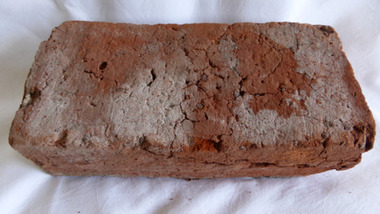
Functional object - Brick, 94 Merri Street Warrnambool, Circa 1850
The building at 94 Merri St is amongst the earliest buildings in Warrnambool. It was possibly constructed before 1854 and maybe as early as 1848. The original building consisted of four main rooms under a hip roof. The outer walls were masonry , apparently rubble The Heritage Council indcate that on the balance of probabilities this was the general store of Richard Osbourne and John Moffat Chisholm built in 1847-48.The building at 94 Merri Street had historical and architectural significance to the state of Victoria. It was a rare example of surviving, pre separation building with associated interest in its materials and components It is associated with Richard Osbourne who founded the Warrnambool Examiner(1851_1889) and the town’s first historian. Architecturally, the significance of the house lay in the hand -wrought timber framing. All the major timbers in this building had been hand sawn. The Gold rush of the 1850’s saw this process mechanised. A kitchen fireplace in the rear skillion included a large block of Merri Creek Mudstone, a combination of “tufa” and clay that was used in the Warrnambool District as an excellent substitute for fire bricks. The house was demolished in 2011 and items of significance were salvaged, this brick being one. While some bricks were imported, there is evidence that there were a number of brick burning businesses in operation around this time. However it is difficult to ascertain to which group this brick belongs. Red clay rectangular brick. Contains some small gravel like material, possibly ferrous buckshot, grey mortar remnants on side and diagonal crack along one side.warrnambool, 94 merri street, richard osbourne, john moffat chisholm, hand sawn timber, brick, building materials -
 Emerald Museum & Nobelius Heritage Park
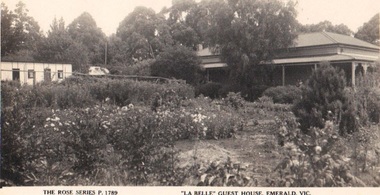
Photograph/postcard, 'La Belle' Guest House, Emerald, Vic, c 1940's
Tim Kennedy built 'La Belle' Guest House circa 1890 - 1920. It became 'The Grange' sometime after 1942. The guest house was on Belgrave/Gembrook Road between IGA and the Shell Petrol Station. Unfortunately the guest house was demolished around 1983.Guest houses of the DandenongsSepia postcard, Rose Series depicting early guest house in EmeraldFront: The Rose Series Postcard, 'La Belle' Guest House, Emerald Vic. Back:: (handwritten) Dear Miss Hartnell, Just to wish you a Happy Xmas and bright new year I hope and trust that your health is better it was just twelve months yesterday since I returned from Olinda how time flies Doesent it, with all good wishes yours sincerely B George'la belle', the grange, tim kennedy -
 Eltham District Historical Society Inc
Photograph, Russell Yeoman, 66 Susan Street, Eltham, 1965c
Farmhouse built in the late 1800s by the Crozier Family. Subsequently owned by the Hill Family. Purchased in the early 1960s and by 1965 the property was owned by the Shire of Eltham. Employees of the Shire lived in the house. In 2006 the Shire of Nillumbik demolished the house which had been subject to extensive vandalism. In accordance with heritage advicde and a permit condition a sign was placed on the site outlining the history of the building. This was installed and remained in place till about 2016 when it was removed. The lands adjoins Alistair Knox Park. By 2010 the Eltham Skate Park was developed. In 2022 a major renovation and extension took place. Sources: EDHS Newsletter No 171 November 2006 and Google Street View. Digital file only; created from original colour positive slide transparencyeltham, streets, houses, susan street, alistair knox park, eltham skate park, russell yeoman collection, fc holden sedan -
 Orbost & District Historical Society
black and white photograph, mid 1930s
This is a photograph of McKillop's Bridge probably taken just after its rebuilding. The current McKillop’s Bridge was built by the Country Roads Board in two stages between 1931-36, during which its height was raised after the original bridge superstructure was washed away in record floods of January 1934, prior to its original official opening. In its reconstructed form the original concrete abutments were turned into additional piers and the welded-steel trusses were cantilevered back over them to meet the new higher road approaches. "McKillops Bridge was Heritage listed due to its social and technological significance – the steel trusses' arc-welded construction technique was a pretty big deal in the 1930s. It was once an important route for cattlemen, who used the ford across the Snowy in the years preceding the bridge's existence"This is a pictorial record of McKillop's Bridge just after its construction.A black / white photograph of a wooden bridge across a river. At the bottom right is a man with his back to the camera. He is looking at flood debris on the bank. At the bottom left are two men near a pylon.on back - McKillops Bridgebridge-mckillop's snowy-river-bridge -
 Orbost & District Historical Society
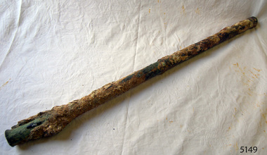
sounding lead, before 1871
This plummet came from S.S. Auckland which was wrecked at Beware Reef near Cape Conran in 1871. The S.S. Aukland was a two masted , iron screw steamer built by C. Mitchell & Co. in 1863 in Newcastle, England. It was owned by the Australasian Steam Navigation Company who modified it in Sydney. In May 1871, on a voyage from Melbourne to Sydney, it ran into breakers and struck Beware Reef. Conditions were foggy and there was a strong easterly current. All passengers and crew were rescued by the S.S. Macedon. (ref. Victorian Heritage Database)The S.S. Aucckland is archaelogically significant. Beware Reef Marine Sanctuary is located five kilometres south east of Cape Conran. On one side of the reef lie the remains of old shipwrecks, including the SS Auckland, a steamship wrecked on the reef in 1871.A tapered conical shaped piece of a lead, a plummet, used for measuring the depth of water.s.s.aukland beware-reef sounding-lead shipwreck -
 Flagstaff Hill Maritime Museum and Village
Nail
The iron-hulled, four-masted barque, the Falls of Halladale, was a bulk carrier of general cargo. She left New York in August 1908 on her way to Melbourne and Sydney. In her hold, along with 56,763 tiles of unusual beautiful green American slates (roofing tiles), 5,673 coils of barbed wire, 600 stoves, 500 sewing machines, 6500 gallons of oil, 14400 gallons of benzene, and many other manufactured items, were 117 cases of crockery and glassware. Three months later and close to her destination, a navigational error caused the Falls of Halladale to be wrecked on a reef off the Peterborough headland at 3 am on the morning of the 15th of November, 1908. The captain and 29 crew members all survived, but her valuable cargo was largely lost, despite two salvage attempts in 1908-09 and 1910. ABOUT THE ‘FALLS OF HALLADALE’ (1886 - 1908) Built: in1886 by Russell & Co., Greenock shipyards, River Clyde, Scotland, UK. The company was founded in 1870 (or 1873) as a partnership between Joseph Russell (1834-1917), Anderson Rodger and William Todd Lithgow. During the period 1882-92 Russell & Co., standardised designs, which sped up their building process so much that they were able to build 271 ships over that time. In 1886 they introduced a 3000 ton class of sailing vessel with auxiliary engines and brace halyard winches. In 1890 they broke the world output record. Owner: Falls Line, Wright, Breakenridge & Co, 111 Union Street, Glasgow, Scotland. Configuration: Four masted sailing ship; iron-hulled barque; iron masts, wire rigging, fore & aft lifting bridges. Size: Length 83.87m x Breadth 12.6m x Depth 7.23m, Gross tonnage 2085 ton Wrecked: the night of 14th November 1908, Curdies Inlet, Peterborough south west Victoria Crew: 29 The Falls of Halladale was a four-masted sailing ship built-in 1886 in Glasgow, Scotland, for the long-distance cargo trade and was mostly used for Pacific grain trade. She was owned by Wright, Breakenridge & Co of Glasgow and was one of several Falls Line ships, all of which were named after waterfalls in Scotland. The lines flag was of red, blue and white vertical stripes. The Falls of Halladale had a sturdy construction built to carry maximum cargo and able to maintain full sail in heavy gales, one of the last of the ‘windjammers’ that sailed the Trade Route. She and her sister ship, the Falls of Garry, were the first ships in the world to include fore and aft lifting bridges. Previous to this, heavily loaded vessels could have heavy seas break along the full length of the deck, causing serious injury or even death to those on deck. The new, raised catwalk-type decking allowed the crew to move above the deck stormy conditions. This idea is still used today on the most modern tankers and cargo vessels and has proved to be an important step forward in the safety of men at sea. On 4th August 1908, with new sails, 29 crew, and 2800 tons of cargo, the Falls of Halladale left New York, bound for Melbourne and Sydney via the Cape of Good Hope. The cargo on board was valued at £35,000 and included 56,763 tiles of American slate roofing tiles (roof slates), 5,673 coils of barbed wire, 600 stoves, 500 sewing machines, 6,500 gallons of oil, 14,400 gallons of benzene, plumbing iron, 117 cases of crockery and glassware and many other manufactured items. The Falls of Halladale had been at sail for 102 days when, at 3 am on the night of 14th November 1908, under full sail in calm seas with a six knots breeze behind and misleading fog along the coast, the great vessel rose upon an ocean swell and settled on top of a submerged reef near Peterborough on the south-west Victoria’s coast. The ship was jammed on the rocks and began filling with water. The crew launched the two lifeboats and all 29 crew landed safely on the beach over 4 miles away at the Bay of Islands. The postmistress at Peterborough, who kept a watch for vessels in distress, saw the stranding and sent out an alert to the local people. A rescue party went to the aid of the sailors and the Port Campbell rocket crew was dispatched, but the crew had all managed to reach shore safely by the time help arrived. The ship stayed in full sail on the rocky shelf for nearly two months, attracting hundreds of sightseers who watched her slowly disintegrate until the pounding seas and dynamiting by salvagers finally broke her back, and her remains disappeared back into deeper water. The valuable cargo was largely lost, despite two salvage attempts in 1908-09 and 1910. Further salvage operations were made from 1974-1986, during which time 22,000 slate tiles were recovered with the help of 14 oil drums to float them, plus personal artefacts, ship fittings, reams of paper and other items. The Court of Marine Inquiry in Melbourne ruled that the foundering of the ship was entirely due to Captain David Wood Thomson’s navigational error, not too technical failure of the Clyde-built ship. The shipwreck is a popular site for divers, about 300m offshore and in 3 – 15m of water. Some of the original cargo can be seen at the site, including pieces of roof slate and coils of barbed wire. The Falls of Halladale shipwreck is listed on the Victorian Heritage Register (No. S255). She was one of the last ships to sail the Trade Routes. She is one of the first vessels to have fore and aft lifting bridges. She is an example of the remains of an International Cargo Ship and also represents aspects of Victoria’s shipping industry. The wreck is protected as a Historic Shipwreck under the Commonwealth Historic Shipwrecks Act (1976).25½" of round solid copper nail. Recovered from "Falls of Halladale". Ship's nail.flagstaff hill, warrnambool, shipwrecked coast, flagstaff hill maritime museum, maritime museum, shipwreck coast, flagstaff hill maritime village, great ocean road, nail, copper nail, falls of halladale, ship's nail -
 Flagstaff Hill Maritime Museum and Village
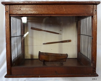
Craft - Ship Model, after 1850
This little model dinghy or rowing boat, together with its two oars and its display case, was made by Edward Richter using timber from the New Zealand-built schooner, the Enterprise, wrecked in Lady Bay, Warrnambool, in 1850 after only three years of sailing. The dinghy was originally presented to the old Warrnambool Museum and transferred to Flagstaff Hill along with its two descriptive card tags. EDWARD RICHTER (1853-1937) Edward Richter was the son of Henry and Charlotte Richter, who migrated from London and arrived in Port Phillip, Victoria, in 1850. Henry had worked in the Bank of England in London. In Australia, he worked for the Morning Herald and was a business partner in the Geelong Daily News. He served in the Volunteer Corps and had the honour of being one of the 500 Volunteers in the firing party at the grave of Sir Charles Hotham, Governor of Victoria. In Warrnambool, Henry was the Host/Licensee of the Royal Archer Hotel. He was also connected with Sheldrich's brewery (the Western Brewery) there. Henry and Charlotte’s son Edward was born in Collingwood, a Melbourne suburb, in 1853. The family moved to Warrnambool in 1867. In 1878 Edward married Susan (nee Saltz) and they had a family of twelve children. Sadly their son, Edward Henry Richter, died from drowning in Warrnambool’s Shelly Beech in 1907, aged 29 years. Edward was a prominent Warrnambool citizen. He worked as a coach painter and his hobbies included model making. He made this model dinghy and presented it to the old Warrnambool Museum in the late 1800s. He also made some model violins that are now in the care of the Warrnambool and District Historical Society. After the museum closed, this model was eventually transferred to Flagstaff Hill. Edward’s son, Herman, was also a model maker, making model boats and even boats in bottles. Edward passed away in Warrnambool in 1937. THE ENTERPRISE 1847-1850 The wooden, two-masted schooner Enterprise was built in New Zealand in 1847 and registered in Melbourne, Australia. The Enterprise carried cargos of agricultural produce and other commodities for trade between the ports of the Colony. On September 14, 1850, the Enterprise was at anchor in Lady Bay under its Master, James Gardiner Caughtt, loaded with a cargo of wheat and potatoes. A strong south-easterly wind caused the vessel to drag on its only anchor and the rudder was lost. The gale-force wind blew it sideways and it became grounded. A local indigenous Buckawall, braved the rough sea to take a line from the shore to the Enterprise. All five members of the crew were able to make it safely to land. The Enterprise was wrecked. The Enterprise wreck was in an area called Tramway Jetty in Lady Bay. Since then the area became the location of the Lady Bay Hotel and now, in 2019, it is in the grounds of the Deep Blue Apartments. In fact, with the constantly changing coastline through built-up sand, the wreck site is now apparently under the No 2 Caravan Park on Pertobe Road, perhaps 150 metres from the high tide. Its location was found by Ian McKiggan (leader of the various searches in the 1980s for the legendary Mahogany Ship). DIFFERENTIATING the New Zealand Schooner “Enterprise” from John Fawkner’s “Enterprize“ Dr Murray Johns, Melbourne, says in his article The Mahogany Ship Story “… As I documented in 1985, the Warrnambool wreck was of an entirely different ship, also called Enterprize [with the spelling ‘Enterprise’], but built in New Zealand in 1847. Fawkner’s ship had already been sold to Captain Sullivan in 1845 and was wrecked on the Richmond Pier in northern New South Wales early in 1847. “ - (further details are in NOTES: and FHMV documents)The model of a dinghy is significant for its association wreck of the schooner Enterprise, now on the Victorian Heritage List VHR S238, being a New Zealand built but Australian owned coastal trader. The wreck is also significant, by connection with the Enterprise, for its association with indigenous hero Buckawall who saved the lives of the five crew on board. The maker of the model, Edward Richter, is significant as a member of one of Warrnambool’s pioneering families, which has contributed to the growth of the community in several ways over the years, living, working and bringing up their families in the coastal city. Ship model; model of a small wooden boat or dinghy and wooden two oars, displayed in timber case with open sides that have vertical wire strands from top to bottom. The model was made by Mr Edward Richter from the timber of the schooner Enterprise, built in New Zealand 1847 and wrecked three years later in Lady Bay, Warrnambool.Handwritten tag in pen and ink: "Model of Boat made from the timber of the schooner "Enterprise" wrecked at Warrnambool" Type written tag "MODEL DINGEY Made from Timber of Schooner "Enterprise". Made and presented by Mr Edward Richter."flagstaff hill, warrnambool, shipwrecked coast, flagstaff hill maritime museum, maritime museum, shipwreck coast, flagstaff hill maritime village, great ocean road, wooden ship building, carpentry, ship modelling hobby, dinghy, dingey, dingy, edward richter, enterprise, lady bay warrnambool, schooner enterprise, wreck of the enterprise 1850, richter family, warrnambool history, buckawall -
 Flagstaff Hill Maritime Museum and Village
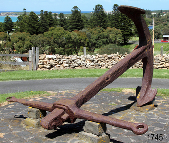
Equipment - Anchor, Circa 1886
The anchor is one of four that were carried by the FALLS OF HALLADALE when she was wrecked near Peterborough in 1908. This Rodger’s Anchor was raised from the wreck site by Flagstaff Hill divers (Peter Ronald, Colin Goodall and Gary Hayden) in 1974 and is on permanent outdoor display at the Maritime Village. The imposing 2-tonne artefact required a raft of fourteen 44-gallon drums to raise it from the seabed before it was towed by a crayfish boat to the wharf crane at Port Campbell for loading onto land transport. Following Lieutenant William Rodger’s patent in 1831, anchor design moved away from the separate attachment of straight arms and flat flutes to each side of a long shaft. Rodger’s innovation included the forging of both arms and their flutes as a single uniformly curved piece which was then attached to the crown of the shank by a thick horizontal bolt. The two-inch diameter hole for the securing through-bolt at the crown is clearly visible in this example, the bolt dislodged by corrosion and now missing. The FALLS OF HALLADALE was a four-masted, iron-hulled barque, built by Russell and Co at Greenock in 1866 for the Falls Line of Wright & Breakenridge, Glasgow. The ship was 275 feet long, 42 feet wide, with a 24 feet draft and weighed 2,085 tonnes. She was built to carry as much cargo as possible rather than for speed. Her unmistakably square bilge earned her the title of “warehouse-type” ship and her iron masts and wire rigging enabled her to maintain full sail even in gale conditions. In 1908, with new sails, 29 crew, and 2800 tons of cargo in her hold, the FALLS OF HALLADALE left New York, bound for Melbourne and Sydney via the Cape of Good Hope. 102 days later, at 3 am on the 14th of November, under full sail and in calm seas, with a six knots breeze behind and a misleading fog along the coast, the great vessel rose upon an ocean swell and settled on top of a shelf of rock near Peterborough. There she stayed for nearly two months until the pounding seas and dynamiting by salvagers finally broke her back, and her remains disappeared back into deeper water. The iron-hulled, four-masted barque, the Falls of Halladale, was a bulk carrier of general cargo. She left New York in August 1908 on her way to Melbourne and Sydney. In her hold, along with 56,763 tiles of unusual beautiful green American slates (roofing tiles), 5,673 coils of barbed wire, 600 stoves, 500 sewing machines, 6500 gallons of oil, 14400 gallons of benzene, and many other manufactured items, were 117 cases of crockery and glassware. Three months later and close to her destination, a navigational error caused the Falls of Halladale to be wrecked on a reef off the Peterborough headland at 3 am on the morning of the 15th of November, 1908. The captain and 29 crew members all survived, but her valuable cargo was lost, despite two salvage attempts in 1908-09 and 1910. ABOUT THE ‘FALLS OF HALLADALE’ (1886 - 1908) Built: in1886 by Russell & Co., Greenock shipyards, River Clyde, Scotland, UK. The company was founded in 1870 (or 1873) as a partnership between Joseph Russell (1834-1917), Anderson Rodger and William Todd Lithgow. During the period 1882-92 Russell & Co., standardised designs, which sped up their building process so much that they were able to build 271 ships over that time. In 1886 they introduced a 3000-ton class of sailing vessel with auxiliary engines and brace halyard winches. In 1890 they broke the world output record. Owner: Falls Line, Wright, Breakenridge & Co, 111 Union Street, Glasgow, Scotland. Configuration: Four-masted sailing ship; iron-hulled barque; iron masts, wire rigging, fore & aft lifting bridges. Size: Length 83.87m x Breadth 12.6m x Depth 7.23m, Gross tonnage 2085 ton Wrecked: the night of 14th November 1908, Curdies Inlet, Peterborough south west Victoria Crew: 29 The Falls of Halladale was a four-masted sailing ship built in 1886 in Glasgow, Scotland, for the long-distance cargo trade and was mostly used for the Pacific grain trade. She was owned by Wright, Breakenridge & Co of Glasgow and was one of several Falls Line ships, all of which were named after waterfalls in Scotland. The lines flag was of red, blue and white vertical stripes. The Falls of Halladale had a sturdy construction built to carry maximum cargo and able to maintain full sail in heavy gales, one of the last of the ‘windjammers’ that sailed the Trade Route. She and her sister ship, the Falls of Garry, were the first ships in the world to include fore and aft lifting bridges. Previous to this, heavily loaded vessels could have heavy seas break along the full length of the deck, causing serious injury or even death to those on deck. The new, raised catwalk-type decking allowed the crew to move above the deck in stormy conditions. This idea is still used today on the most modern tankers and cargo vessels and has proved to be an important step forward in the safety of men at sea. On 4th August 1908, with new sails, 29 crew, and 2800 tons of cargo, the Falls of Halladale left New York, bound for Melbourne and Sydney via the Cape of Good Hope. The cargo on board was valued at £35,000 and included 56,763 tiles of American slate roofing tiles (roof slates), 5,673 coils of barbed wire, 600 stoves, 500 sewing machines, 6,500 gallons of oil, 14,400 gallons of benzene, plumbing iron, 117 cases of crockery and glassware and many other manufactured items. The Falls of Halladale had been at sail for 102 days when, at 3 am on the night of 14th November 1908, under full sail in calm seas with a six knots breeze behind and misleading fog along the coast, the great vessel rose upon an ocean swell and settled on top of a submerged reef near Peterborough on the south-west Victoria’s coast. The ship was jammed on the rocks and began filling with water. The crew launched the two lifeboats and all 29 crew landed safely on the beach over 4 miles away at the Bay of Islands. The postmistress at Peterborough, who kept a watch for vessels in distress, saw the stranding and sent out an alert to the local people. A rescue party went to the aid of the sailors and the Port Campbell rocket crew was dispatched, but the crew had all managed to reach shore safely by the time help arrived. The ship stayed in full sail on the rocky shelf for nearly two months, attracting hundreds of sightseers who watched her slowly disintegrate until the pounding seas and dynamiting by salvagers finally broke her back, and her remains disappeared back into deeper water. The valuable cargo was largely lost, despite two salvage attempts in 1908-09 and 1910. Further salvage operations were made from 1974-1986, during which time 22,000 slate tiles were recovered with the help of 14 oil drums to float them, plus personal artefacts, ship fittings, reams of paper and other items. The Court of Marine Inquiry in Melbourne ruled that the foundering of the ship was entirely due to Captain David Wood Thomson’s navigational error, not too technical failure of the Clyde-built ship. The shipwreck is a popular site for divers, about 300m offshore and in 3 – 15m of water. Some of the original cargo can be seen at the site, including pieces of roof slate and coils of barbed wire.The shipwreck of the FALLS OF HALLADALE is of state significance – Victorian Heritage Register No. S255. She was one of the last ships to sail the Trade Routes. She is one of the first vessels to have fore and aft lifting bridges. She is an example of the remains of an International Cargo Ship and also represents aspects of Victoria’s shipping industry. The wreck is protected as a Historic Shipwreck under the Commonwealth Historic Shipwrecks Act (1976).A large iron Rodger’s anchor recovered from the wreck of the FALLS OF HALLADALE. It has a rounded crown, curved arms and moulded flutes. Heavy duty iron stock with round eyes at either end, fitted over shank and fixed into position by a wedge-shaped metal locking pin. Shackle missing but severed securing bolt remaining in shank. The presence of an empty bolthole at the crown junction of shank and arms confirms Rodger’s type. Corroded from 66 years submersion in seawater but otherwise structure is sound.warrnambool, shipwreck coast, flagstaff hill, shipwrecked coast, flagstaff hill maritime village, flagstaff hill maritime museum, shipwreck artefact, maritime museum, falls of halladale, rodger’s anchor, peterborough reef, 1908 shipwreck, anchor, last days of sail, great clipper ships -
 Flagstaff Hill Maritime Museum and Village
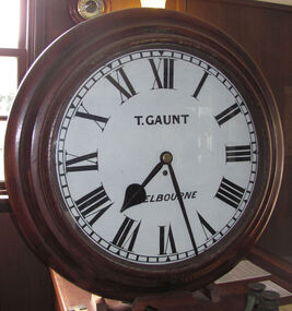
Instrument - Clock, c. 1860s
The clock was either made or sold by T. Gaunt & Co. of Melbourne, a manufacturer, importer and retailer of a wide variety of goods including jewellery, clocks and watches, navigational and measuring instruments, dinnerware, glassware and ornaments. Thomas Gaunt photograph was included in an album of security identity portraits of members of the Victorian Court, Centennial International Exhibition, Melbourne, 1888. Thomas Gaunt History: Thomas Gaunt established Melbourne's leading watchmaking, optical and jewellery business during the second half of the 19th century. Gaunt arrived in Melbourne in 1852, and by 1858 had established his own business at 14 Little Bourke Street. Around 1869 he moved to new premises in Bourke Street on the corner of Royal Arcade, Gaunt's shop quickly became a Melbourne institution. Gaunt proudly advertised that he was 'The only watch manufacturer in the Australian colonies'. While many watches and clocks may have had Gaunt's name on the dial, few would have been made locally. Gaunt did make some watches for exhibitions, and perhaps a few expensive watches for wealthy individuals. Gaunt's received a telegraph signal from Melbourne Observatory each day to correct his main clock and used this signal to rate and repair ship's chronometers and good quality watches. His main horological manufacturing was directed at turret clocks for town halls, churches and post offices. These tended to be specific commissions requiring individualised design and construction. He made the clock for the Melbourne Post Office lobby, to a design by Government Astronomer Robert Ellery, and won an award at the 1880-81 Melbourne International Exhibition for his turret clock for the Emerald Hill Town Hall. He became well known for his installation of a chronograph at Flemington Racecourse in 1876, which showed the time for the race, accurate to a quarter of a second. The firm also installed the clockwork and figures for Gog and Magog in the Royal Arcade. Thomas Gaunt also developed a department that focused on scientific instrumentation, making thermometers and barometers (from imported glass tubes), telescopes, surveying instruments and microscopes. Another department specialised in electroplating for trophies, awards and silverware, and the firm manufactured large amounts of ecclesiastical gold ware and silverware, for the church including St Patrick's Cathedral. There are no records that disclose the number of employees in the firm, but it was large enough for Gaunt to hold an annual picnic for the watchmakers and apprentices at Mordialloc from 1876; two years previously they had successfully lobbied Gaunt to win the eight hour day. Gaunt's workforce was reportedly very stable, with many workers remaining in the business for 15 to 30 years. Gaunt's wife Jane died on September 1894, aged 64. They had one son and six daughters, but only three daughters survived to adulthood. Two became nuns at the Abbotsford Convent and one daughter, Cecelia Mary Gaunt (died 28 July 1941), married William Stanislaus Spillane on 22 September 1886 and had a large family. Gaunt died at his home in Coburg, Victoria, leaving an estate valued at ₤41,453. The business continued as T. Gaunt & Co. after his death. Post Office and Clock History: Warrnambool’s Post Office has been in existence since 1857, when it was originally situated on the corner of Timor and Gilles Street. In March 1864 the Warrnambool Borough Council purchased this clock from Henry Walsh Jnr. for the sum of £25, “to be put up in front of the Post Office”. Henry Walsh Jnr was the eldest son of Melbourne’s Henry Walsh, maker and retailer of clocks, watches, thermometers and jewellery. In 1854 Henry Walsh Jnr. began business in Warrnambool as a watchmaker and jeweller later becoming a Councillor with now a local street named after him. The Post Office was extensively remodelled in 1875-76. Early photographs of this building show that the clock was installed on the northern outside wall, Timor Street, under the arches and between the 2 centre windows, where it could be seen by passers-by. Although spring loaded clocks date back to the 15th century, and fob and pocket watches evolving from these date to the 17th century, personal pocket watches were only affordable to the very fortunate. Public clocks such as this Post Office clock provided opportunity for all to know the time, and for those in possession of a personal watch to check and set their own timepieces to the correct time. During post office reservations during the 1970s the clock was removed and was eventually donated to the Flagstaff Collection. The Clock’s maker Thomas Gaunt, is historically significant and was an established and well renowned scientific instrument and clock maker in Melbourne during the 1860s. He was at that time the only watchmaker in the Australian colonies. In the 1870’s and 1880’s he won many awards for his clocks and was responsible for sending time signals to other clocks in the city and rural areas, enabling many businesses and organisations to accurate set their clocks each day. Warrnambool Borough Council purchased this clock from Henry Walsh Jnr. for the sum of £25 and the clock used to stand in front of the Warrnambool post office to allow ordinary citizens to set their time pieces as they walked by. The item is not only important because it was made by a significant early colonial clock maker and retailed by a locally known clock maker and jeweler but also that it was installed in the Warrnambool Post Office a significantly historical building in it's own right. Built in 1857 and regarded as one of the oldest postal facilities in Australia, with a listing on the National Heritage Database, (ID 15656). This 1864 hall clock originates from the Warrnambool Post Office. The clock glass is hinged to the top of the clock face and has a catch at the bottom. The metal rim of the glass is painted black. The clock face is metal, painted white, with black Roman numerals and markings for minutes and five minutes. The tip of the small hour hand is shaped like a leaf. "T. GAUNT / MELBOURNE" is printed in black on the clock face. The winding key hole is just below the centre of the clock face. The key winds a fusee chain mechanism, attached to the brass mainspring barrel that powers the pendulum with an 8-day movement. The speed of the clock can be adjusted by changing the position of the weight on the pendulum, lengthening or shortening the swing; raising the pendulum shortens its swing and speeds up the clock. The metal fusee mechanism has an inscription on it. The rectangular wooden casing is with a convex curve at the bottom that has a hinged door with a swivel latch. The original stained surface has been painted over with a matte black. There are two other doors that also allow access to the clock’s workings. The case fits over the pendulum and workings at the rear and attaches to the clock by inserting four wooden pegs into holes in the sides of the case then into the back of the clock. A flat metal plate has been secured by five screws onto the top of the case and a hole has been cut into it for the purpose of hanging up the clock. There is a nail inside the case, possibly used for a place to the key."T. GAUNT MELBOURNE" is printed on the clock face. “6 1 3” embossed on the back of the fusee mechanism behind the clock. warrnambool, shipwrecked coast, flagstaff hill, flagstaff hill maritime museum, maritime museum, shipwreck coast, flagstaff hill maritime village, shipwrecked artefact, clock, warrnambool post office, fusee, henry walsh jnr, thomas gaunt, t gaunt & co, post office clock -
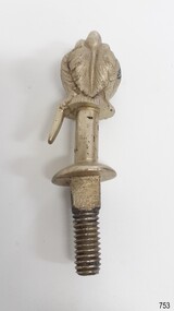 Flagstaff Hill Maritime Museum and Village
Decorative object - Buggy Fitting, Circa 1855
This ornate fitting for a horse-drawn vehicle was amongst the items recovered from the Schomberg over one hundred years after it was wrecked. ABOUT THE SCHOMBERG (October 6 to December 27, 1855)- When the ship Schomberg was launched in 1855, she was considered the most perfect clipper ship ever to be built. James Baine’s Black Ball Line had commissioned her for their fleet of passenger liners. The Aberdeen builders designed her to sail faster than the clippers designed the three-masted wooden clipper ship to be fast. The timber used for the diagonal planking was British oak with layers of Scottish larch. This luxury emigrant vessel was designed for superior comfort. She had ventilation ducts to provide air to the lower decks and a dining saloon, smoking room, library and bathrooms for the first-class passengers. The master for Schomberg’s maiden voyage was Captain ‘Bully’ Forbes. He drunkenly predicted at her launch that he would make the journey between Liverpool and Melbourne in 60 days. Schomberg departed Liverpool on 6 October 1855 with 430 passengers and 3000 tons of cargo including iron rails and equipment intended the build the Geelong Railway and a bridge over the Yarra from Melbourne to Hawthorn. The poor winds slowed Schomberg’s sail across the equator. She was 78 days out of Liverpool when she ran aground on a sand spit near Peterborough, Victoria, on 27 December; the sand spit and currents were not marked on Forbes’s map. The ship’s Chief Officer spotted the coastal steamer SS Queen at dawn and sent a signal. The master of the SS Queen approached the stranded vessel and all of Schomberg’s passengers safely disembarked. In 1975, 120 years after the Schomberg was wrecked, divers from Flagstaff Hill found an ornate communion set at the wreck site along with many other artefacts. In 1978 a diamond ring was discovered under the concretion in the lid of the communion set, which is currently on display. Former Director of Flagstaff Hill, Peter Ronald, had salvaged most of the artefacts from the wreck. The Schomberg has historical significance as one of the first luxurious ships built to bring emigrants to Australia to cash in on the gold rush era. And is included on the Victorian Heritage Register (VHR S612). The collection of Schomberg artefacts held at Flagstaff Hill Museum is primarily significant because of the relationship between these recovered items having a high potential to interpret the story of the Schomberg and its foundering during a storm. The shipwreck is of additional historically significance for representing aspects of Victoria’s shipping history and for its association with the first passenger ship, which was designed not only to be the fastest and most luxurious of its day but foundered on its maiden voyage to Australia.Ornate buggy or coach fitting with feather plumes on top, and a screw thread on the bottom. Silver plated,.warrnambool, flagstaff-hill, flagstaff-hill-maritime-museum, shipwreck-coast, flagstaff-hill-maritime-village, schomberg, shipwrecked-artefact, clipper ship, black ball line, 1855 shipwreck, aberdeen clipper ship, captain forbes, peterborough shipwreck, ss queen, artifact, ornate fitting, buggy fitting -
 Flagstaff Hill Maritime Museum and Village
Functional object - Service Bell, 1855
This service bell was recovered from the wreck of the ship Schomberg. The Schomberg was a large three-masted full-ship rigged wooden ship built in 1855 by Alexander Hall and Co in Aberdeen, Scotland for James Baines' famous Black Ball Line at £43,103. The vessel was 288 feet (88 meters) in length, with a beam of 45 feet (14 meters), a depth of 29.5 feet (8.99 meters) of 2,284 tons. The mainmast was 210 feet (64 meters) high and she carried 3.3 acres of sail. The vessel was constructed with three skins. One planked fore and aft, and two diagonally planked, fastened together with screw-threaded trunnels (wooden rails). The Schomberg is one of only three clipper wrecks in Victorian waters that operated the England to Australia run. While the other two, Empress of the Sea and Lightning, were built by the famous American shipbuilder, Donald Mac Kay. Schomberg was an attempt to build a faster ship than Mac Kay and a vessel fast enough to break the sailing record to Australia. The Schomberg sailed on her maiden voyage from Liverpool on 6 October 1855, under the command of Captain James Forbes, on its maiden voyage to Australia with a general cargo, jewellery, spirits, machinery, and 2,000 tons of iron rails and equipment intended to build the Melbourne to Geelong Railway and a bridge over the Yarra from Melbourne to Hawthorn. She also carried a cow for fresh milk, pens for fowls and pigs, plus 90,000 gallons of water for washing and drinking. She also carried 17,000 letters and 31,800 newspapers. There were approximately 473 passengers and a crew of 105. It was hoped that Schomberg would make Melbourne in sixty days, setting a record for the voyage, but light winds at the equator dashed those expectations. The ship sighted Moonlight Head in south west Victoria on Christmas Day but through a deadly combination of wind, currents and unmarked sand spits, the vessel gently ran aground on 26 December 1855 on a spit that juts into Newfield Bay, just east of Curdies Inlet, and the present town of Peterborough. Fortunately, the SS Queen was nearby and managed to save all passengers and crew. The steamers Keera and Maitland were dispatched to salvage the passenger's baggage and the more valuable cargo. Other salvage attempts were made, but deteriorating weather made the work impossible, and within two weeks the Schomberg's hull was broken up and the vessel abandoned. The wrecking of the Schomberg caused quite the public stir particularly in light of the fact the vessel was supposed to be, the most perfect clipper ship ever built. Captain Forbes was charged in the Supreme Court under suspicion that he was playing cards with two female passengers below decks when his ship ran aground. Despite a protest meeting, two inquiries and the court proceedings, he was found not guilty and cleared of all charges. In 1975, divers from Flagstaff Hill, including Peter Ronald, found an ornate communion set at the wreck. The set comprised a jug, two chalices, a plate and a lid. The lid did not fit any of the other objects and in 1978 a piece of the lid broke off, revealing a glint of gold. As museum staff carefully examined the lid and removed marine growth, they found a diamond ring, which is currently on display in the Great Circle Gallery at the Flagstaff Hill Maritime museum that also displays ship fittings and equipment, personal effects. Most of the artefacts were salvaged from the wreck by Peter Ronald, former director of Flagstaff Hill.The Schomberg has historical significance as one of the first luxurious ships built to bring emigrants to Australia to cash in on the gold rush era. And is included on the Victorian Heritage Register (VHR S612). The collection of Schomberg artefacts held at Flagstaff Hill Museum is primarily significant because of the relationship between these recovered items having a high potential to interpret the story of the Schomberg and its foundering during a storm. The shipwreck is of additional historically significance for representing aspects of Victoria’s shipping history and for its association with the first passenger ship, which was designed not only to be the fastest and most luxurious of its day but foundered on its maiden voyage to Australia.Bell; small service bell, brass, with heavy encrustation. Bell has a square loop at the top. The bell was recovered from the wreck of the Schomberg.Nonewarrnambool, flagstaff-hill, flagstaff-hill-maritime-museum, shipwreck-coast, flagstaff-hill-maritime-village, schomberg, shipwrecked-artefact, clipper ship, black ball line, 1855 shipwreck, aberdeen clipper ship, captain forbes, peterborough shipwreck, ss queen, bell, service bell -
 Flagstaff Hill Maritime Museum and Village
Oar, early 20th century
This oar is from the Lifeboat Warrnambool, which is on sit at Flagstaff Hill Maritime Village. The construction of the lifeboat ‘Warrnambool’ began 15th September 1909 and was completed almost 12 months later, 1st September 1910. It was built at the Government Dockyard in Williamstown, Victoria, along the lines designed by the Great Britain’s Royal Lifeboat Institution, and included whaleback decks fore and aft, mast and centreboard, and rudder and tiller hung from the sternpost. It could be propelled by both sail and oar. At that time Captain Ferguson was Chief Harbour Master and Mr Beagley was foreman boat builder. Mr Beagley built the lifeboat with his fellow workmen. The boat was described as “… a fine piece of workmanship and does credit to her builders and designers…” It had all the latest improvements in shape, disposition of weight and watertight compartments, and it had space for a large number of people in addition to the crew. It appears that 'H Meiers' whose signature was on the plaque that was found concealed in the hull, was involved with the building of the lifeboat. His signature and the dates of the start and finish of the boat’s construction are pencilled on the raw timber 'plaque' found in the hull in the early 1990’s when the lifeboat was being restored. It is interesting that the ‘Melbourne Directory’ of 1911, published by Sands and MacDougal, lists McAuley and Meiers, boat builders, Nelson Place foreshore, between Pasco and Parker Streets, Williamstown, (Victorian Heritage Database, ‘Contextual History, Maritime Facilities’), It is quite possibly the business of the person whose name is inscribed on the lifeboat plaque. Flagstaff Hill’s documentation also mentions that the keel was laid at ‘Harry Myers, boat builders, Williamstown, Melbourne’ – the name ‘Myers’ can also be spelled ‘Meiers’, which could be the same person as the Meiers in “McAuley and Meiers” (as mentioned in genealogy lines of Myers). The new lifeboat, to be named ‘Warrnambool’ was brought to town by train and launched at the breakwater on 1st March 1911 using the Titan crane (the old lifeboat built in 1858, was then returned to Melbourne in 1911). This new lifeboat was stationed at Warrnambool in a shed located at the base of the Breakwater, adjacent to the slipway. A winch was used to bring it in and out of the water. The lifeboat ‘Warrnambool’ was similar in size to the old lifeboat but far superior in design, build and sea-going qualities such as greater manoeuvrability. The ‘self-righting, self-draining’ design was “practically non-capsizeable” and even if the boat overturned it would right itself to an even keel and the water would drain away. The hull was built of New Zealand Kauri, using double diagonal planking, laid in two layers at right angles, with a layer of canvas and red lead paint between the timbers to help seal the planking. It has “… plenty of freeboard, high watertight spaces between the deck and bottom… through which pipes lead…” The backbone timbers were made of Jarrah. The lifeboat Warrnambool was one of several rescue boats used at Port Fairy and Warrnambool in early 1900's. In late 1914 the Warrnambool lifeboat and crew were used to help find what was left of the tragic wreckage of the Antares, and were able to discover the body of one of the crewmen, which they brought back to Warrnambool. Between 1951 and 1954 the lifeboat was manned under the guidance of Captain Carrington. He held lifeboat practice each month on a Sunday morning, to comply with the Ports and Harbour’s request that lifeboats be manned by a strong and competent crew, ready for action in case of emergency. In the early 1960’s it ended its service as a lifeboat and was used in Port Fairy as a barge to help dredge the Moyne River, bolted to the Port Fairy lifeboat. Flagstaff Hill obtained the Warrnambool in 1975. In 1984 it was on display at Flagstaff Hill Maritime Village, Warrnambool. On 23rd May 1990 she was lifted from the water and placed in a cradle for restoration. The name ‘WARRNAMBOOL could be seen faintly on the lifeboat before it was restored. It was during the restoration that Flagstaff Hill's boat builder discovered the 'plaque' inside the hull. A copy of the blueprint plans has the name “V.E.E. Gotch” printed on it. His advertisement in Footscray’s ‘Independent’ newspaper of Saturday 11th May 1901 states he is “Principal and Skilled member (Naval Architect) to the Court of Marine Inquiry of Victoria and holds classes for naval architectural drawing and arithmetic.” The oar is significant for its association with the lifeboat WARRNAMBOOL, which is significant for its half century service to the local community as a lifesaving vessel. She was also used to help retrieve the body of a shipwrecked crew member of the ANTARES. Large wooden oar, shaped two handgrip with tapering shaft to large flattened blade, (2) copper reinforcing strips on blade. Sweep oar is from the Lifeboat Warrnambool. flagstaff hill, warrnambool, shipwrecked-coast, flagstaff-hill, flagstaff-hill-maritime-museum, maritime-museum, shipwreck-coast, flagstaff-hill-maritime-village, oar, lifeboat warrnambool, sweep oar -
 Flagstaff Hill Maritime Museum and Village
Functional object - Watch Chains, ca 1855
The concretion of silver watch chains was recovered from the wreck of the Schomberg over one hundred years later. Schomberg was a large three-masted full-ship rigged wooden ship built in 1855 by Alexander Hall and Co in Aberdeen, Scotland for James Baines' famous Black Ball Line at £43,103. The vessel was 288 feet (88 meters) in length, with a beam of 45 feet (14 meters), a depth of 29.5 feet (8.99 meters) of 2,284 tons. The mainmast was 210 feet (64 meters) high and she carried 3.3 acres of sail. The vessel was constructed with three skins. One planked fore and aft, and two diagonally planked, fastened together with screw-threaded trunnels (wooden rails). The Schomberg is one of only three clipper wrecks in Victorian waters that operated the England -to- Australia run. While the other two, Empress of the Sea and Lightning, were built by the famous American shipbuilder, Donald Mac Kay. Schomberg was an attempt to build a faster ship than Mac Kay and a vessel fast enough to break the sailing record to Australia. The Schomberg sailed on her maiden voyage from Liverpool on 6 October 1855, under the command of Captain James Forbes, on its maiden voyage to Australia with general cargo, jewellery, spirits, machinery, and 2,000 tons of iron rails and equipment intended to build the Melbourne to Geelong Railway and a bridge over the Yarra from Melbourne to Hawthorn. She also carried a cow for fresh milk, pens for fowls and pigs, plus 90,000 gallons of water for washing and drinking. She also carried 17,000 letters and 31,800 newspapers. There were approximately 473 passengers and a crew of 105. It was hoped that Schomberg would make Melbourne in sixty days, setting a record for the voyage, but light winds at the equator dashed those expectations. The ship sighted Moonlight Head in southwest Victoria on Christmas Day but through a deadly combination of wind, currents and unmarked sand spits, the vessel gently ran aground on 26 December 1855 on a spit that juts into Newfield Bay, just east of Curdies Inlet, and the present town of Peterborough. Fortunately, the SS Queen was nearby and managed to save all passengers and crew. The steamers Keera and Maitland were dispatched to salvage the passenger's baggage and the more valuable cargo. Other salvage attempts were made, but deteriorating weather made the work impossible, and within two weeks the Schomberg's hull was broken up and the vessel abandoned. The wrecking of the Schomberg caused quite a public stir, particularly in light of the fact the vessel was supposed to be, the most perfect clipper ship ever built. Captain Forbes was charged in the Supreme Court under suspicion that he was playing cards with two female passengers below decks when his ship ran aground. Despite a protest meeting, two inquiries and the court proceedings, he was found not guilty and cleared of all charges. In 1975, divers from Flagstaff Hill, including Peter Ronald, found an ornate communion set at the wreck. The set comprised a jug, two chalices, a plate and a lid. The lid did not fit any of the other objects and in 1978 a piece of the lid broke off, revealing a glint of gold. As museum staff carefully examined the lid and removed marine growth, they found a diamond ring, which is currently on display in the Great Circle Gallery at the Flagstaff Hill Maritime Museum that also displays ship fittings and equipment, and personal effects. Most of the artefacts were salvaged from the wreck by Peter Ronald, former director of Flagstaff Hill.The Schomberg has historical significance as one of the first luxurious ships built to bring emigrants to Australia to cash in on the gold rush era. And is included on the Victorian Heritage Register (VHR S612). The collection of Schomberg artefacts held at Flagstaff Hill Museum is primarily significant because of the relationship between these recovered items having a high potential to interpret the story of the Schomberg and its foundering during a storm. The shipwreck is of additional historically significance for representing aspects of Victoria’s shipping history and for its association with the first passenger ship, which was designed not only to be the fastest and most luxurious of its day but foundered on its maiden voyage to Australia.Conglomerated cluster of silver watch chains, encased in concretion at both ends (1 chain is separated). They were recovered from the wreck of the Schomberg.warrnambool, flagstaff-hill, flagstaff-hill-maritime-museum, shipwreck-coast, flagstaff-hill-maritime-village, schomberg, shipwrecked-artefact, clipper ship, black ball line, 1855 shipwreck, aberdeen clipper ship, captain forbes, peterborough shipwreck, ss queen, watch chain -
 Flagstaff Hill Maritime Museum and Village
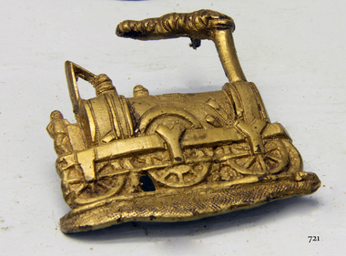
Accessory - Badge, Before 1855
The badge recovered from the Schomberg wreck is believed to depict one of the first steam engines. The engine's design by Charles Tayleur & Co. was to be produced for the Great Western Railway in England. The first nineteen of these locomotives were ordered by Isambard Kingdom Brunel for the Great Western Railway including six 2-2-2 Charles Tayleur locomotives. They were built by Charles Tayleur and Company, which later the Vulcan Foundry. The locomotives were unsuccessful and were rapidly supplemented by the Star Class locomotives ordered by Daniel Gooch once he had been appointed as the Locomotive Engineer. As built, they comprised two groups of three, the first group, was delivered in 1837. This locomotive was the first to run on the Great Western Railway when it was tested on 28 December 1837 from its shed at West Drayton. It was withdrawn in 1843 but was rebuilt as a 2-2-2T tank locomotive and returned to service in 1846, running in this form until 1868. It survived for two more years at Reading as a stationary boiler. It is named after the workshops where it was built, which themselves were named after the Roman god of fire. (Although a supposition, it is possible that the owner was a passenger on the ill-fated Schomberg and that they worked either for the Great Western Railway or the Vulcan Foundry that made the engine in the 1830s.) Wreck of the Schomberg: Schomberg was a large three-masted full-ship rigged wooden ship built in 1855 by Alexander Hall and Co in Aberdeen, Scotland for James Baines' famous Black Ball Line at £43,103. The vessel was 288 feet (88 meters) in length, with a beam of 45 feet (14 meters), a depth of 29.5 feet (8.99 meters) of 2,284 tons. The mainmast was 210 feet (64 meters) high and she carried 3.3 acres of sail. The vessel was constructed with three skins. One planked fore and aft, and two diagonally planked, fastened together with screw-threaded trunnels (wooden rails). The Schomberg is one of only three clipper wrecks in Victorian waters that operated the England to Australia run. While the other two, Empress of the Sea and Lightning, were built by the famous American shipbuilder, Donald Mac Kay. Schomberg was an attempt to build a faster ship than Mac Kay and a vessel fast enough to break the sailing record to Australia. The Schomberg sailed on her maiden voyage from Liverpool on 6 October 1855, under the command of Captain James Forbes, on its maiden voyage to Australia with a general cargo, jewellery, spirits, machinery, and 2,000 tons of iron rails and equipment intended to build the Melbourne to Geelong Railway and a bridge over the Yarra from Melbourne to Hawthorn. She also carried a cow for fresh milk, pens for fowls and pigs, plus 90,000 gallons of water for washing and drinking. She also carried 17,000 letters and 31,800 newspapers. There were approximately 473 passengers and a crew of 105. It was hoped that Schomberg would make Melbourne in sixty days, setting a record for the voyage, but light winds at the equator dashed those expectations. The ship sighted Moonlight Head in southwest Victoria on Christmas Day but through a deadly combination of wind, currents, and unmarked sand spits, the vessel gently ran aground on 26 December 1855 on a spit that juts into Newfield Bay, just east of Curdies Inlet, and the present town of Peterborough. Fortunately, the SS Queen was nearby and managed to save all passengers and crew. The steamers Keera and Maitland were dispatched to salvage the passenger's baggage and the more valuable cargo. Other salvage attempts were made, but deteriorating weather made the work impossible, and within two weeks the Schomberg's hull was broken up and the vessel abandoned. The wrecking of the Schomberg caused quite a public stir, particularly in light of the fact the vessel was supposed to be, the most perfect clipper ship ever built. Captain Forbes was charged in the Supreme Court under suspicion that he was playing cards with two female passengers below decks when his ship ran aground. Despite a protest meeting, two inquiries, and the court proceedings, he was found not guilty and cleared of all charges. In 1975, divers from Flagstaff Hill, including Peter Ronald, found an ornate communion set at the wreck. The set comprised a jug, two chalices, a plate, and a lid. The lid did not fit any of the other objects and in 1978 a piece of the lid broke off, revealing a glint of gold. As museum staff carefully examined the lid and removed marine growth, they found a diamond ring, which is currently on display in the Great Circle Gallery at the Flagstaff Hill Maritime Museum that also displays ship fittings and equipment, and personal effects. Most of the artefacts were salvaged from the wreck by Peter Ronald, former director of Flagstaff Hill.The Schomberg has historical significance as one of the first luxurious ships built to bring emigrants to Australia to cash in on the gold rush era. And is included on the Victorian Heritage Register (VHR S612). The collection of Schomberg artefacts held at Flagstaff Hill Museum is primarily significant because of the relationship between these recovered items having a high potential to interpret the story of the Schomberg and its foundering during a storm. The shipwreck is of additional historical significance for representing aspects of Victoria’s shipping history and for its association with the first passenger ship, which was designed not only to be the fastest and most luxurious of its day but foundered on its maiden voyage to Australia.Gold coloured brass badge depicting an 1840's steam engine or locomotive with the figure of a fireman standing on the back. Smoke is coming from the smokestack. The reverse has three holes, possible where a mounting pin or fastener was attached. The badge was recovered from the wreck of the Schomberg.warrnambool, flagstaff-hill, flagstaff-hill-maritime-museum, shipwreck-coast, flagstaff-hill-maritime-village, schomberg, shipwrecked-artefact, clipper ship, black ball line, 1855 shipwreck, captain forbes, ss queen, badge, charles tayleur, great western railway, vulcan foundry, isambard kingdom brunel, locomoive, brooch -
 Flagstaff Hill Maritime Museum and Village
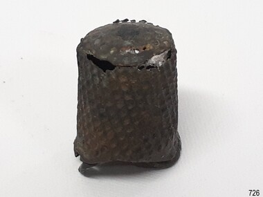
Domestic object - Thimble, Circa 1855
The thimble was recovered from the wreck of the vessel, Schomberg. The Schomberg was a large three-masted full-ship rigged wooden ship built in 1855 by Alexander Hall and Co in Aberdeen, Scotland for James Baines' famous Black Ball Line at £43,103. The vessel was 288 feet (88 meters) in length, with a beam of 45 feet (14 meters), a depth of 29.5 feet (8.99 meters) of 2,284 tons. The mainmast was 210 feet (64 meters) high and she carried 3.3 acres of sail. The vessel was constructed with three skins. One planked fore and aft, and two diagonally planked, fastened together with screw-threaded trunnels (wooden rails). The Schomberg is one of only three clipper wrecks in Victorian waters that operated the England to Australia run. While the other two, Empress of the Sea and Lightning, were built by the famous American shipbuilder, Donald Mac Kay. Schomberg was an attempt to build a faster ship than Mac Kay and a vessel fast enough to break the sailing record to Australia. The Schomberg sailed on her maiden voyage from Liverpool on 6 October 1855, under the command of Captain James Forbes, on its maiden voyage to Australia with general cargo, jewellery, spirits, machinery, and 2,000 tons of iron rails and equipment intended to build the Melbourne to Geelong Railway and a bridge over the Yarra from Melbourne to Hawthorn. She also carried a cow for fresh milk, pens for fowls and pigs, plus 90,000 gallons of water for washing and drinking. She also carried 17,000 letters and 31,800 newspapers. There were approximately 473 passengers and a crew of 105. It was hoped that Schomberg would make Melbourne in sixty days, setting a record for the voyage, but light winds at the equator dashed those expectations. The ship sighted Moonlight Head in southwest Victoria on Christmas Day but through a deadly combination of wind, currents and unmarked sand spits, the vessel gently ran aground on 26 December 1855 on a spit that juts into Newfield Bay, just east of Curdies Inlet, and the present town of Peterborough. Fortunately, the SS Queen was nearby and managed to save all passengers and crew. The steamers Keera and Maitland were dispatched to salvage the passenger's baggage and the more valuable cargo. Other salvage attempts were made, but deteriorating weather made the work impossible, and within two weeks the Schomberg's hull was broken up and the vessel abandoned. The wrecking of the Schomberg caused quite the public stir particularly in light of the fact the vessel was supposed to be, the most perfect clipper ship ever built. Captain Forbes was charged in the Supreme Court under suspicion that he was playing cards with two female passengers below decks when his ship ran aground. Despite a protest meeting, two inquiries and the court proceedings, he was found not guilty and cleared of all charges. In 1975, divers from Flagstaff Hill, including Peter Ronald, found an ornate communion set at the wreck. The set comprised a jug, two chalices, a plate and a lid. The lid did not fit any of the other objects and in 1978 a piece of the lid broke off, revealing a glint of gold. As museum staff carefully examined the lid and removed marine growth, they found a diamond ring, which is currently on display in the Great Circle Gallery at the Flagstaff Hill Maritime museum that also displays ship fittings and equipment, personal effects. Most of the artefacts were salvaged from the wreck by Peter Ronald, former director of Flagstaff Hill.The Schomberg has historical significance as one of the first luxurious ships built to bring emigrants to Australia to cash in on the gold rush era. And is included on the Victorian Heritage Register (VHR S612). The collection of Schomberg artefacts held at Flagstaff Hill Museum is primarily significant because of the relationship between these recovered items having a high potential to interpret the story of the Schomberg and its foundering during a storm. The shipwreck is of additional historically significance for representing aspects of Victoria’s shipping history and for its association with the first passenger ship, which was designed not only to be the fastest and most luxurious of its day but foundered on its maiden voyage to Australia. Thimble, metal, some of the dimples are corroded through. flagstaff hill, flagstaff hill maritime museum and village, warrnambool, maritime museum, maritime village, great ocean road, shipwreck coast, schomberg, shipwreck coast. schomberg, 1855, peterborough shipwreck, artefact, thimble, sewing accesdory, sewing equipment, haberdashery, finger protection -
 Flagstaff Hill Maritime Museum and Village
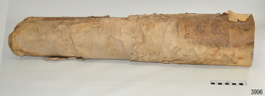
Functional object - Paper, circa 1908
This roll or reel of paper was part of a consignment carried as cargo of the Falls of Halladale. The iron-hulled, four-masted barque, the Falls of Halladale, was a bulk carrier of general cargo. She left New York in August 1908 on her way to Melbourne and Sydney. In her hold, along with 56,763 tiles of unusual beautiful green American slates (roofing tiles), 5,673 coils of barbed wire, 600 stoves, 500 sewing machines, 6500 gallons of oil, 14400 gallons of benzene, and many other manufactured items, were 117 cases of crockery and glassware. Three months later and close to her destination, a navigational error caused the Falls of Halladale to be wrecked on a reef off the Peterborough headland at 3 am on the morning of the 15th of November, 1908. The captain and 29 crew members all survived, but her valuable cargo was largely lost, despite two salvage attempts in 1908-09 and 1910. ABOUT THE ‘FALLS OF HALLADALE’ (1886 - 1908) Built: in1886 by Russell & Co., Greenock shipyards, River Clyde, Scotland, UK. The company was founded in 1870 (or 1873) as a partnership between Joseph Russell (1834-1917), Anderson Rodger and William Todd Lithgow. During the period 1882-92 Russell & Co., standardised designs, which sped up their building process so much that they were able to build 271 ships over that time. In 1886 they introduced a 3000 ton class of sailing vessel with auxiliary engines and brace halyard winches. In 1890 they broke the world output record. Owner: Falls Line, Wright, Breakenridge & Co, 111 Union Street, Glasgow, Scotland. Configuration: Four masted sailing ship; iron-hulled barque; iron masts, wire rigging, fore & aft lifting bridges. Size: Length 83.87m x Breadth 12.6m x Depth 7.23m, Gross tonnage 2085 ton Wrecked: the night of 14th November 1908, Curdies Inlet, Peterborough south west Victoria Crew: 29 The Falls of Halladale was a four-masted sailing ship built-in 1886 in Glasgow, Scotland, for the long-distance cargo trade and was mostly used for Pacific grain trade. She was owned by Wright, Breakenridge & Co of Glasgow and was one of several Falls Line ships, all of which were named after waterfalls in Scotland. The lines flag was of red, blue and white vertical stripes. The Falls of Halladale had a sturdy construction built to carry maximum cargo and able to maintain full sail in heavy gales, one of the last of the ‘windjammers’ that sailed the Trade Route. She and her sister ship, the Falls of Garry, were the first ships in the world to include fore and aft lifting bridges. Previous to this, heavily loaded vessels could have heavy seas break along the full length of the deck, causing serious injury or even death to those on deck. The new, raised catwalk-type decking allowed the crew to move above the deck stormy conditions. This idea is still used today on the most modern tankers and cargo vessels and has proved to be an important step forward in the safety of men at sea. On 4th August 1908, with new sails, 29 crew, and 2800 tons of cargo, the Falls of Halladale left New York, bound for Melbourne and Sydney via the Cape of Good Hope. The cargo on board was valued at £35,000 and included 56,763 tiles of American slate roofing tiles (roof slates), 5,673 coils of barbed wire, 600 stoves, 500 sewing machines, 6,500 gallons of oil, 14,400 gallons of benzene, plumbing iron, 117 cases of crockery and glassware and many other manufactured items. The Falls of Halladale had been at sail for 102 days when, at 3 am on the night of 14th November 1908, under full sail in calm seas with a six knots breeze behind and misleading fog along the coast, the great vessel rose upon an ocean swell and settled on top of a submerged reef near Peterborough on the south-west Victoria’s coast. The ship was jammed on the rocks and began filling with water. The crew launched the two lifeboats and all 29 crew landed safely on the beach over 4 miles away at the Bay of Islands. The postmistress at Peterborough, who kept a watch for vessels in distress, saw the stranding and sent out an alert to the local people. A rescue party went to the aid of the sailors and the Port Campbell rocket crew was dispatched, but the crew had all managed to reach shore safely by the time help arrived. The ship stayed in full sail on the rocky shelf for nearly two months, attracting hundreds of sightseers who watched her slowly disintegrate until the pounding seas and dynamiting by salvagers finally broke her back, and her remains disappeared back into deeper water. The valuable cargo was largely lost, despite two salvage attempts in 1908-09 and 1910. Further salvage operations were made from 1974-1986, during which time 22,000 slate tiles were recovered with the help of 14 oil drums to float them, plus personal artefacts, ship fittings, reams of paper and other items. The Court of Marine Inquiry in Melbourne ruled that the foundering of the ship was entirely due to Captain David Wood Thomson’s navigational error, not too technical failure of the Clyde-built ship. The shipwreck is a popular site for divers, about 300m offshore and in 3 – 15m of water. Some of the original cargo can be seen at the site, including pieces of roof slate and coils of barbed wire. The roll of paper is an example of cargo brought to Australia in the early 20th century. It is also significant for its association with the Falls of Halladale shipwreck, which is listed on the Victorian Heritage Register (No. S255). She was one of the last ships to sail the Trade Routes. She is one of the first vessels to have fore and aft lifting bridges. She is an example of the remains of an International Cargo Ship and also represents aspects of Victoria’s shipping industry. The wreck is protected as a Historic Shipwreck under the Commonwealth Historic Shipwrecks Act (1976).Roll of paper. Paper was part of a large consignment of paper listed as part of the cargo manifesto. It was recovered from the wreck of the ship Falls of Halladale. A section of the paper has been cut away after it was recovered.flagstaff hill, warrnambool, shipwrecked coast, flagstaff hill maritime museum, maritime museum, shipwreck coast, flagstaff hill maritime village, great ocean road, falls of halladale, shipwreck peterborough, 1908 shipwreck, great clipper ships, russell & co., paper, reel, roll, paper reel, paper roll, cargo, consignment -
 Flagstaff Hill Maritime Museum and Village
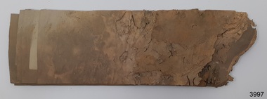
Functional object - Paper, circa 1908
These sheets of paper were from a roll or reel of paper that was part of a consignment carried as cargo of the Falls of Halladale. The iron-hulled, four-masted barque, the Falls of Halladale, was a bulk carrier of general cargo. She left New York in August 1908 on her way to Melbourne and Sydney. In her hold, along with 56,763 tiles of unusual beautiful green American slates (roofing tiles), 5,673 coils of barbed wire, 600 stoves, 500 sewing machines, 6500 gallons of oil, 14400 gallons of benzene, and many other manufactured items, were 117 cases of crockery and glassware. Three months later and close to her destination, a navigational error caused the Falls of Halladale to be wrecked on a reef off the Peterborough headland at 3 am on the morning of the 15th of November, 1908. The captain and 29 crew members all survived, but her valuable cargo was largely lost, despite two salvage attempts in 1908-09 and 1910. ABOUT THE ‘FALLS OF HALLADALE’ (1886 - 1908) Built: in1886 by Russell & Co., Greenock shipyards, River Clyde, Scotland, UK. The company was founded in 1870 (or 1873) as a partnership between Joseph Russell (1834-1917), Anderson Rodger and William Todd Lithgow. During the period 1882-92 Russell & Co., standardised designs, which sped up their building process so much that they were able to build 271 ships over that time. In 1886 they introduced a 3000 ton class of sailing vessel with auxiliary engines and brace halyard winches. In 1890 they broke the world output record. Owner: Falls Line, Wright, Breakenridge & Co, 111 Union Street, Glasgow, Scotland. Configuration: Four-masted sailing ship; iron-hulled barque; iron masts, wire rigging, fore & aft lifting bridges. Size: Length 83.87m x Breadth 12.6m x Depth 7.23m, Gross tonnage 2085 ton Wrecked: the night of 14th November 1908, Curdies Inlet, Peterborough south west Victoria Crew: 29 The Falls of Halladale was a four-masted sailing ship built-in 1886 in Glasgow, Scotland, for the long-distance cargo trade and was mostly used for Pacific grain trade. She was owned by Wright, Breakenridge & Co of Glasgow and was one of several Falls Line ships, all of which were named after waterfalls in Scotland. The lines flag was of red, blue and white vertical stripes. The Falls of Halladale had a sturdy construction built to carry maximum cargo and able to maintain full sail in heavy gales, one of the last of the ‘windjammers’ that sailed the Trade Route. She and her sister ship, the Falls of Garry, were the first ships in the world to include fore and aft lifting bridges. Previous to this, heavily loaded vessels could have heavy seas break along the full length of the deck, causing serious injury or even death to those on deck. The new, raised catwalk-type decking allowed the crew to move above the deck stormy conditions. This idea is still used today on the most modern tankers and cargo vessels and has proved to be an important step forward in the safety of men at sea. On 4th August 1908, with new sails, 29 crew, and 2800 tons of cargo, the Falls of Halladale left New York, bound for Melbourne and Sydney via the Cape of Good Hope. The cargo on board was valued at £35,000 and included 56,763 tiles of American slate roofing tiles (roof slates), 5,673 coils of barbed wire, 600 stoves, 500 sewing machines, 6,500 gallons of oil, 14,400 gallons of benzene, plumbing iron, 117 cases of crockery and glassware and many other manufactured items. The Falls of Halladale had been at sail for 102 days when, at 3 am on the night of 14th November 1908, under full sail in calm seas with a six knots breeze behind and misleading fog along the coast, the great vessel rose upon an ocean swell and settled on top of a submerged reef near Peterborough on the south-west Victoria’s coast. The ship was jammed on the rocks and began filling with water. The crew launched the two lifeboats and all 29 crew landed safely on the beach over 4 miles away at the Bay of Islands. The postmistress at Peterborough, who kept a watch for vessels in distress, saw the stranding and sent out an alert to the local people. A rescue party went to the aid of the sailors and the Port Campbell rocket crew was dispatched, but the crew had all managed to reach shore safely by the time help arrived. The ship stayed in full sail on the rocky shelf for nearly two months, attracting hundreds of sightseers who watched her slowly disintegrate until the pounding seas and dynamiting by salvagers finally broke her back, and her remains disappeared back into deeper water. The valuable cargo was largely lost, despite two salvage attempts in 1908-09 and 1910. Further salvage operations were made from 1974-1986, during which time 22,000 slate tiles were recovered with the help of 14 oil drums to float them, plus personal artefacts, ship fittings, reams of paper and other items. The Court of Marine Inquiry in Melbourne ruled that the foundering of the ship was entirely due to Captain David Wood Thomson’s navigational error, not too technical failure of the Clyde-built ship. The shipwreck is a popular site for divers, about 300m offshore and in 3 – 15m of water. Some of the original cargo can be seen at the site, including pieces of roof slate and coils of barbed wire. The roll of paper from which the sheets were cut is an example of cargo brought to Australia in the early 20th century. It is also significant for its association with the Falls of Halladale shipwreck, which is listed on the Victorian Heritage Register (No. S255). She was one of the last ships to sail the Trade Routes. She is one of the first vessels to have fore and aft lifting bridges. She is an example of the remains of an International Cargo Ship and also represents aspects of Victoria’s shipping industry. The wreck is protected as a Historic Shipwreck under the Commonwealth Historic Shipwrecks Act (1976).Wad of paper sheets that was cut from a roll of paper. Three sides of the sheets are straight and the other side is rough due to exposure to sea water for many years. The roll was part of a large consignment of paper listed on the cargo manifesto of the wreck of the ship Falls of Halladale. flagstaff hill, warrnambool, shipwrecked coast, flagstaff hill maritime museum, maritime museum, shipwreck coast, flagstaff hill maritime village, great ocean road, falls of halladale, shipwreck peterborough, 1908 shipwreck, great clipper ships, russell & co., paper, paper reel, paper roll, cargo, consignment, paper sheets, wad of paper -
 Flagstaff Hill Maritime Museum and Village
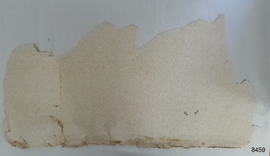
Decorative object - Wallpaper sample, c. 1870s to early 1900s
This wallpaper section is from the original Warrnambool Lighthouse Keeper's Quarters built in the late 1850s on Middle Island, and the building was moved to Flagstaff Hill in 1871-72. The wallpaper was salvaged from Assistant Keeper's residence (Shipwreck Museum) during heritage works in 2023, to upgrade the ageing exhibition space in the historic building.The wallpaper section is significant for its association with the Warrnambool Lighthouse Keeper's Quarters from the late 19th to early 20th centuries. It is also significant as an example of the paper, method of displaying and pattern on the paper, an indication of the materials and patterns available to decorate homes in those times.Wallpaper sample, irregular shape. Wallpaper has been recovered from behind a 1970s built feature in the Warrnambool Lighthouse Keeper's Residence, Assistant's Quarters. The light-coloured textured paper has a small cream-coloured embossed pattern. The sample has two layers of thickness and the back layer is two overlapping pieces. There are holes along the edge where the paper was fixed to another surface.flagstaff hill, warrnambool, maritime museum, shipwreck coast, warrnambool lighthouse keeper's quarters, wall paper, domestic furnishings, wall covering, domestic soft furnishing, wall decoration, wallpaper section, wallpaper, late 19th century wallpaper -
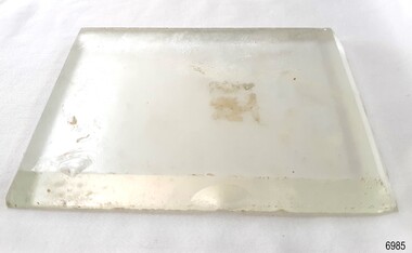 Flagstaff Hill Maritime Museum and Village
Functional object - Glass Lens, 1886-1908
This glass lens was recovered from the wreck of the Falls of Halladale. Its purpose is unknown but could have been a clock face cover, a lamp or torch lens or even the lens from underwater equipment. The FALLS of HALLADALE 1886 - 1908- The sailing ship Falls of Halladale was an iron-hulled, four-masted barque, used as a bulk carrier of general cargo. She left New York in August 1908 bound for Melbourne and Sydney. In her hold was general cargo consisting of roof tiles, barbed wire, stoves, oil, benzene, and many other manufactured items. After three months at sea and close to her destination, a navigational error caused the Falls of Halladale to be wrecked on a reef off the Peterborough headland on the 15th of November, 1908. The captain and 29 crew members survived, but her cargo was largely lost, despite two salvage attempts in 1908-09 and 1910. The Court of Marine Inquiry in Melbourne ruled that the foundering of the ship was entirely due to Captain David Wood Thomson's navigational error, not too technical failure of the Clyde-built ship. The Falls of Halladale was built in1886 by Russell & Co., at Greenock shipyards on the River Clyde, Scotland for Wright, Breakenridge & Co of Glasgow. The ship had a sturdy construction built to carry maximum cargo and was able to maintain full sail in heavy gales, one of the last of the 'windjammers' that sailed the Trade Route. She and her sister ship, the Falls of Garry, were the first ships in the world to include fore and aft lifting bridges. The new raised catwalk-type decking allowed the crew to move above the deck in stormy conditions. This glass lens is significant for its association with the wreck of the sailing ship the Falls of Halladale. The Falls of Halladale shipwreck is listed on the Victorian Heritage (No. S255). She was one of the last ships to sail the Trade Routes from Europe and the Americas. Also of significance is that the vessel was one of the first ships to have fore and aft lifting bridges as a significant safety feature still in use on modern vessels today. The subject model is an example of an International Cargo Ship used during the 19th and early 20th centuries to transport goods around the world and represents aspects of Victoria’s shipping industry. Glass lens; transparent glass rectangle with bevelled edges. It was recovered from the wreck of the Falls of Halladale. flagstaff hill, warrnambool, flagstaff hill maritime museum and village, shipwreck coast, great ocean road, shipwreck artefact, falls of halladale, glass lens, rectangular lens, glass cover -
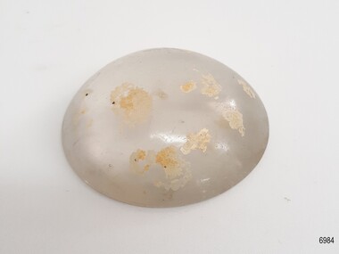 Flagstaff Hill Maritime Museum and Village
Functional object - Glass Lens, 1886-1908
This glass lens was recovered from the wreck of the Falls of Halladale. Its purpose is unknown but could have been a lamp or torch lens or even the lens from underwater equipment. The FALLS of HALLADALE 1886 - 1908- The sailing ship Falls of Halladale was an iron-hulled, four-masted barque, used as a bulk carrier of general cargo. She left New York in August 1908 bound for Melbourne and Sydney. In her hold was general cargo consisting of roof tiles, barbed wire, stoves, oil, benzene, and many other manufactured items. After three months at sea and close to her destination, a navigational error caused the Falls of Halladale to be wrecked on a reef off the Peterborough headland on the 15th of November, 1908. The captain and 29 crew members survived, but her cargo was largely lost, despite two salvage attempts in 1908-09 and 1910. The Court of Marine Inquiry in Melbourne ruled that the foundering of the ship was entirely due to Captain David Wood Thomson's navigational error, not too technical failure of the Clyde-built ship. The Falls of Halladale was built in1886 by Russell & Co., at Greenock shipyards on the River Clyde, Scotland for Wright, Breakenridge & Co of Glasgow. The ship had a sturdy construction built to carry maximum cargo and was able to maintain full sail in heavy gales, one of the last of the 'windjammers' that sailed the Trade Route. She and her sister ship, the Falls of Garry, were the first ships in the world to include fore and aft lifting bridges. The new raised catwalk-type decking allowed the crew to move above the deck in stormy conditions. This glass lens is significant for its association with the wreck of the sailing ship the Falls of Halladale. The Falls of Halladale shipwreck is listed on the Victorian Heritage (No. S255). She was one of the last ships to sail the Trade Routes from Europe and the Americas. Also of significance is that the vessel was one of the first ships to have fore and aft lifting bridges as a significant safety feature still in use on modern vessels today. The subject model is an example of an International Cargo Ship used during the 19th and early 20th centuries to transport goods around the world and represents aspects of Victoria’s shipping industry. Glass lens; transparent glass dome with flat base. Glass has bubbles and several concentric lines on the surface. There are light coloured encrustations on the surface. It was recovered from the wreck of the Falls of Halladale. flagstaff hill, warrnambool, flagstaff hill maritime museum and village, shipwreck coast, great ocean road, shipwreck artefact, falls of halladale, glass lens, glass cover, glass dome -
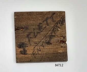 Flagstaff Hill Maritime Museum and Village
Souvenir - Wood sample, Mr John Flett, c1885
This small piece of wood was cut from a rib of the wreck of the Enterprise in c1885 by Mr John Flett (1869 – 1944), whilst it was lying on the beach in Lady Bay, Warrnambool. Mr Flett was about 16 years old at the time and used the wood (with other pieces from the wreck) to make a picture frame. A newspaper report published in the Gippsland Gazette on Tuesday 16th July 1912 titled "An Interesting Relic" describes a picture frame being displayed in Mr. Flett's shop in Warragul which was of interest as it had been made from wood taken from the wreck of the Enterprise when it was lying on the beach at Lady Bay, Warrnambool. This was still in his possession in the 1930’s when Mr. Flett presented the small sample of wood to Mr. Henri Worland of the Warrnambool Museum and Art Gallery - along with a signed letter of ownership. A transcription of the letter is as follows - “Kalos” 12 Yendon Road Glen Huntly S.E.9 Dear Mr Warland, I am enclosing herewith a small piece of timber which, about 50 years ago, I cut from a rib of the old wreck which at that time was well known as the old “Enterprise”. I am prepared to sign a sworn statement that this is a piece of that wreck and has never been out of my possession since I cut it from the wreck. Since returning to the city I visited the museum and inspected the walking stick and small model of a boat, presented I think, by Mr Richie. I notice the different grain of the timber and would suggest that they are not Blue Gum, and the piece I am enclosing is definitely of that Tasmanian timber. Of course there may have been other imported timbers used and only the frame of the vessel made of the Blue Gum; I am not suggesting an error on the part of Mr Richie, who evidently knew the old wreck [in an?] earlier date than I did. The piece I am enclosing was incorporated in an old picture frame which I made 50 years ago, and although not used for many years has always been in my possession. With kind regards Yours faithfully J Flett (signature) P.S. I have other small pieces in a small photo frame which I may let you see some day, but not just now. Mr R. Christian will recognise the other frame when he sees it, as we were working together when it was made. J.F. There were several branches of Fletts living in Warrnambool in the mid to late 1800’s. They were all related and had emigrated from Stromness in the Orkney islands – arriving mostly in the 1850’s on different ships. John Flett’s mother was Jessie Isbister who arrived in Australia in 1852 with her family on board the Ticonderoga. Over 168 passengers died on the voyage including two of Jessie’s sisters and one of her brothers. Mrs Jessie Flett's obituary (titled "An Old Colonist") which appeared in the West Gippsland Gazette on Tuesday 8th September 1914 describes her early connections to Warnambool and the Ticonderoga. John Flett moved from Warrnambool to Birchip, Warragul and later went to Melbourne where he worked for the YMCA. During WW1, he worked at the Caulfield Military Hospital and volunteered for active service with the YMCA in France -caring for the welfare of the soldiers. After the war, he continued to work with the YMCA in a secretarial capacity. THE ENTERPRISE 1847-1850 The wooden, two-masted schooner Enterprise was built in New Zealand in 1847 and registered in Melbourne, Australia. The Enterprise carried a cargo of agricultural produce and other commodities for trade between the ports of the Colony. On September 14, 1850, the Enterprise was at anchor in Lady Bay under its Master, James Gardiner Caughtt, loaded with a cargo of wheat and potatoes. A strong south-easterly wind caused the vessel to drag on its only anchor and the rudder was lost. The gale force wind blew it sideways and it became grounded. A local aboriginal, Buckawall, braved the rough sea to take a line from the shore to the Enterprise. All five members of the crew were able to make it safely to land. The Enterprise was totally wrecked. The Enterprise wreck was in an area called Tramway Jetty in Lady Bay. Since then the area became the location of the Lady Bay Hotel and now, in 2019, it is in the grounds of the Deep Blue Apartments. In fact, with the constantly changing coastline through built-up sand, the wreck site is now apparently under the No 2 Caravan Park in Pertobe Road, perhaps 150 metres from the high tide. Its location was found by Ian McKiggan (leader of the various searches in the 1980s for the legendary Mahogany Ship). DIFFERENTIATING the New Zealand Schooner “Enterprise” from John Fawkner’s “Enterprize“ Dr. Murray Johns, Melbourne, says in his article The Mahogany Ship Story “… In fact, as I documented in 1985, the Warrnambool wreck was of an entirely different ship, also called Enterprize [with the spelling ‘Enterprise’], but built in New Zealand in 1847. Fawkner’s ship had already been sold to a Captain Sullivan in 1845 and was wrecked on the Richmond Pier in northern New South Wales early in 1847. “ - (further details are in NOTES: and FHMV documents) Mr Flett had assumed the timber was Tasmanian Gum as he thought it had come from the Enterprise which had been owned by Mr Fawkner and built in Tasmania but we now know the ship was built in New Zealand and the timber was most probably New Zealand Rimu.This piece of wood is significant for its association with the wreck of the schooner Enterprise, now on the Victorian Heritage List VHR S238, being a New Zealand built but Australian owned coastal trader. The wreck is also significant, by connection with the Enterprise, for its association with indigenous hero Buckawall who saved the lives of the five crew on board. The original owner of the wood (Mr John Flett) is significant as a member of one of Warrnambool’s pioneering families, which has contributed to the growth of the community in several ways over the years, living and working in the area.Small square piece of brown wood with a handwritten inscription on the back. The front is polished with a prominent grain and a shallow indentation along two sides. The back has the words "FLETT" and "ENTERPRISE" written in ink with a line separating them. The back is rough and has two indentations - possibly from a nail or tack. The wood sample is accompanied by a letter. Handwritten letter (two pages) of authenticity by Mr. John Flett to Mr. Worland (Manager of the Warrnambool Museum and Art Gallery). Transcribed below"FLETT" and "ENTERPRISE"flagstaff hill, warrnambool, shipwrecked coast, flagstaff hill maritime museum, maritime museum, shipwreck coast, flagstaff hill maritime village, great ocean road, carpentry, enterprise, lady bay warrnambool, schooner enterprise, wreck of the enterprise 1850, buckawall, shipwreck relic, john flett, warrnambool museum and art gallery, flett relic, letter, flett letter, ticonderoga, henri worland -
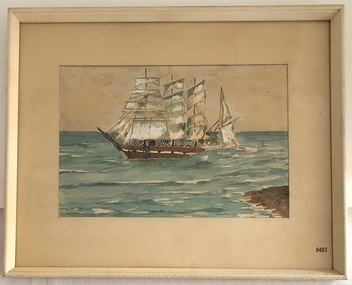 Flagstaff Hill Maritime Museum and Village
Painting - Watercolour painting, Early 20th century
FALLS of HALLADALE - History The Falls of Halladale was a four-masted sailing ship built-in 1886 in Glasgow, Scotland, for the long-distance cargo trade and was mostly used for Pacific grain trade. She had a sturdy construction, built to carry maximum cargo and maintain full sail in heavy gales. She was one of the last of the ‘windjammers’ that sailed the Trade Route and one of the first vessels to include fore and aft lifting bridges, which kept the crew safe and dry in as they moved around the decks in stormy conditions. She was owned by Wright, Breakenridge & Co of Glasgow and was one of several Falls Line ships, all of which were named after waterfalls in Scotland. On 4th August 1908, with new sails, 29 crew, and 2800 tons of cargo, the Falls of Halladale left New York, bound for Melbourne and Sydney via the Cape of Good Hope. The cargo on board was valued at £35,000 and included 56,763 tiles of American slate roofing tiles, 5,673 coils of barbed wire, 600 stoves, 500 sewing machines, 6,500 gallons of oil, 14,400 gallons of benzene, plumbing iron, 117 cases of crockery and glassware and many other manufactured items. The Falls of Halladale had been at sail for 102 days when, at 3 am on the of 14th November 1908, under full sail in calm seas with a six knots breeze behind and misleading fog along the coast, the great vessel rose upon an ocean swell and settled on top of a submerged reef near Peterborough on south-west Victoria’s coast. The ship was jammed on the rocks and began filling with water. The crew launched the two lifeboats and all 29 crew landed safely on the beach over 4 miles away at the Bay of Islands. The postmistress at Peterborough, who kept a watch for vessels in distress, saw the stranding and sent out an alert to the local people. A rescue party went to the aid of the sailors and the Port Campbell rocket crew was dispatched, but the crew had all managed to reach shore safely by the time help arrived. The ship stayed in full sail on the rocky shelf for nearly two months, attracting hundreds of sightseers who watched her slowly disintegrate until the pounding seas and dynamiting by salvagers finally broke her back, and her remains disappeared back into deeper water. The valuable cargo was largely lost, despite two salvage attempts in 1908-09 and 1910. Further salvage operations were made from 1974-1986, during which time 22,000 slate tiles were recovered with the help of 14 oil drums to float them, plus personal artefacts, ship fittings, reams of paper and other items (a list of items held at Flagstaff Hill Maritime Village is included below). The Court of Marine Inquiry in Melbourne ruled that the foundering of the ship was entirely due to Captain David Wood Thomson’s navigational error, not to technical failure of the Clyde-built ship. The shipwreck is a popular site for divers, about 300m offshore and in 3 – 15m of water. Some of the original cargo can be seen at the site, including pieces of roof slate and coils of barbed wire.The Falls of Halladale shipwreck is listed on the Victorian Heritage Register (No. S255). She was one of the last ships to sail the Trade Routes. She is one of the first vessels to have fore and aft lifting bridges. She is an example of the remains of an International Cargo Ship and also represents aspects of Victoria’s shipping industry. The wreck is protected as a Historic Shipwreck under the Commonwealth Historic Shipwrecks Act (1976).Watercolour painting behind glass, framed in the Art Deco style - stippled cream painted wood. There are some age marks under the glass. The painting depicts the Falls of Halladale with its stern under water. The back of the painting contains facts about the shipwreck handwritten in a similar style to the artist’s signature. The artist’s signature is not clear enough to identify. Inscription on the back: Pasted on typed text: Peterborough Handwriting: Falls of Halladale 2085 tons 4 masted iron barque wrecked Saturday November 14th 1908 Captain Thomson crew of 28 !st mate F Pearson 2nd mate T Griffinflagstaff hill, warrnambool, flagstaff hill maritime museum & village, maritime museum, maritime village, shipwreck coast, 1908 shipwreck, falls of halladale, peterborough, peterborough shipwreck, great ocean road, captain thomson, 1880s sailing ship, cargo vessel, 1st mate f pearson, 2nd mate t griffin, watercolour painting -
 Marysville & District Historical Society
Booklet (Item) - Information booklet, Artworkz Tourism, The Big Culvert, Unknown
An information booklet that was produced as a guide to The Big Culvert.An information booklet that was produced as a guide to The Big Culvert. The Big Culvert is a historic granite and bluestone arch along the Yarra Track, a major route to Melbourne through the 1800s. Built in 1870 and a major piece of infrastructure for its time, the heritage listed culvert allowed water to flow under often-flooded the road. The Yarra Track is the former name of the gold fields road from Healesville to the Woods Point and Jordan Goldfields, in Victoria, Australia. A direct route via the Yarra River and the Great Divide was discovered by Rieck in September 1862 and became known as the Yarra Track. Early in 1863, the Victorian Government decided to construct a 193-kilometre (120 mile) road along the route. Its original width varied between 4 and 6 metres (12 and 20 feet), and was designed to accommodate horse-drawn vehicles. The Track involved the climbing of the Black Spur, descent into the Acheron Valley, and then through Marysville to the Cumberland where it followed the existing route.the big culvert, yarra track, victoria, healesville, wood's point goldfields, jordan goldfields, black spur, acheron valley, cumberland valley -
Marysville & District Historical Society
Flyer (Item) - Information flyer, Artworkz Tourism, The Big Culvert, 26-03-2016
An information flyer that was produced as a guide to The Big Culvert.An information flyer that was produced as a guide to The Big Culvert. The Big Culvert is a historic granite and bluestone arch along the Yarra Track, a major route to Melbourne through the 1800s. Built in 1870 and a major piece of infrastructure for its time, the heritage listed culvert allowed water to flow under often-flooded the road. The Yarra Track is the former name of the gold fields road from Healesville to the Woods Point and Jordan Goldfields, in Victoria, Australia. A direct route via the Yarra River and the Great Divide was discovered by Rieck in September 1862 and became known as the Yarra Track. Early in 1863, the Victorian Government decided to construct a 193-kilometre (120 mile) road along the route. Its original width varied between 4 and 6 metres (12 and 20 feet), and was designed to accommodate horse-drawn vehicles. The Track involved the climbing of the Black Spur, descent into the Acheron Valley, and then through Marysville to the Cumberland where it followed the existing route.the big culvert, yarra track, victoria, healesville, wood's point goldfields, jordan goldfields, black spur, acheron valley, cumberland valley -
 Marysville & District Historical Society
Photograph (Item) - Black and white photograph, Unknown
A black and white photograph taken at the unveiling of the sign placed at The Big Culvert.A black and white photograph taken at the unveiling of the sign placed at The Big Culvert. The Big Culvert is a historic granite and bluestone arch along the Yarra Track, a major route to Melbourne through the 1800s. Built in 1870 and a major piece of infrastructure for its time, the heritage listed culvert allowed water to flow under often-flooded the road. The Yarra Track is the former name of the gold fields road from Healesville to the Woods Point and Jordan Goldfields, in Victoria, Australia. A direct route via the Yarra River and the Great Divide was discovered by Rieck in September 1862 and became known as the Yarra Track. Early in 1863, the Victorian Government decided to construct a 193-kilometre (120 mile) road along the route. Its original width varied between 4 and 6 metres (12 and 20 feet), and was designed to accommodate horse-drawn vehicles. The Track involved the climbing of the Black Spur, descent into the Acheron Valley, and then through Marysville to the Cumberland where it followed the existing route.Unveiling of sign/ at "Big Culvert" In front Max Cockerrell and - Rear: second back Geoff Pope R.H.S. rear: Nancy "/ Anne "the big culvert, yarra track, victoria, healesville, wood's point goldfields, jordan goldfields, black spur, acheron valley, cumberland valley -
 Marysville & District Historical Society
Photograph (Item) - Colour photograph, 20-09-2008
A colour photograph of the entrance to The Big Culvert.A colour photograph of the entrance to The Big Culvert. The Big Culvert is a historic granite and bluestone arch along the Yarra Track, a major route to Melbourne through the 1800s. Built in 1870 and a major piece of infrastructure for its time, the heritage listed culvert allowed water to flow under often-flooded the road. The Yarra Track is the former name of the gold fields road from Healesville to the Woods Point and Jordan Goldfields, in Victoria, Australia. A direct route via the Yarra River and the Great Divide was discovered by Rieck in September 1862 and became known as the Yarra Track. Early in 1863, the Victorian Government decided to construct a 193-kilometre (120 mile) road along the route. Its original width varied between 4 and 6 metres (12 and 20 feet), and was designed to accommodate horse-drawn vehicles. The Track involved the climbing of the Black Spur, descent into the Acheron Valley, and then through Marysville to the Cumberland where it followed the existing route.the big culvert, yarra track, victoria, healesville, wood's point goldfields, jordan goldfields, black spur, acheron valley, cumberland valley -
Marysville & District Historical Society
Document (Item) - Heritage Report, Biosis Research Pty Ltd, Heritage Report-Dismantling of Wilks Creek Brdige Deck Marysville, Unknown
A heritage report on the dismantiling of the Wilks Creek Bridge deck in Marysville in Victoria.A heritage report on the dismantiling of the Wilks Creek Bridge deck in Marysville in Victoria. The Wilks Creek Bridge is a former timber and bluestone road bridge on the Yarra Track, and is located just off the Black Spur route, between Narbethong and Marysville, Victoria, Australia. It was built in 1870 to the design of colonial Public Works Department engineer Clement Wilks as part of the construction of a new road to the Woods Point and Jordan Goldfields. Like many bridges of the period, it had a timber superstructure employing squared beams supported by struts and straining pieces, on cut bluestone abutments. The bridge was remodelled around 1900 by engineer John Monash of the famous bridge-engineering firm of Monash and Anderson. It was last used for heavy vehicular traffic in 1980 following the realignment of Marysville Road, and was left to decay until its demolishment in 2008. All timber traces of the bridge were destroyed in the 2009 Black Saturday fires. The handcrafted bluestone masonry wingwalls and abutments, especially shaped to receive timber struts, rate among the earliest of its kind surviving intact in Victoria.wilks creek bridge, yarra track, narbethong, marysville, victoria, clement wilks, wood's point goldfields, jordan goldfields, john monash, monash and anderson, 2009 black saturday bushfires -
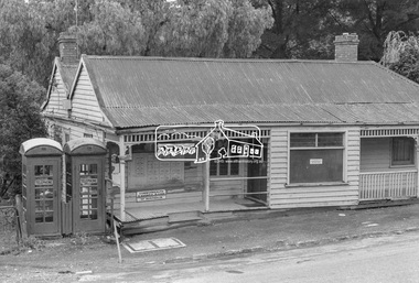 Eltham District Historical Society Inc
Photograph, Warrandyte Post Office, c.1972, 1972
The weatherboard building was built in the 1870s. It operated as a post office from 1876-1972. In 1988, the Warrandyte Historical Society took over the building and created a museum - https://whsoc.org.au/who-we-are/Of regional significance as an early building demonstrating the typical characteristics of early timber structures, and for its historical importance as the only relatively intact building in the town's main street dating from the gold mining period. It is also of local social significance for its important and continuing associations with the social and economic life of the town for over 100 years. - Victorian Heritage DatabaseDigital TIFF file Scan of 9 x 12.5 cm black and white printwarrandyte post office, telephone box, weatherboard house -
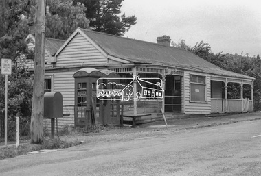 Eltham District Historical Society Inc
Photograph, Warrandyte Post Office, c.1972, 1972
The weatherboard building was built in the 1870s. It operated as a post office from 1876-1972. In 1988, the Warrandyte Historical Society took over the building and created a museum - https://whsoc.org.au/who-we-are/Of regional significance as an early building demonstrating the typical characteristics of early timber structures, and for its historical importance as the only relatively intact building in the town's main street dating from the gold mining period. It is also of local social significance for its important and continuing associations with the social and economic life of the town for over 100 years.- Victorian Heritage DatabaseDigital TIFF file Scan of 9 x 12.5 cm black and white printwarrandyte post office, telephone box, post office -
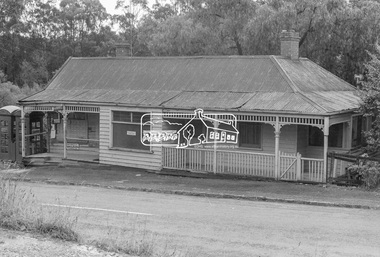 Eltham District Historical Society Inc
Photograph, Warrandyte Post Office, c.1972, 1972
The weatherboard building was built in the 1870s. It operated as a post office from 1876-1972. In 1988, the Warrandyte Historical Society took over the building and created a museum - https://whsoc.org.au/who-we-are/Of regional significance as an early building demonstrating the typical characteristics of early timber structures, and for its historical importance as the only relatively intact building in the town's main street dating from the gold mining period. It is also of local social significance for its important and continuing associations with the social and economic life of the town for over 100 years.- Victorian Heritage DatabaseDigital TIFF file Scan of 9 x 12.5 cm black and white printwarrandyte post office