Showing 771 items matching " creek view"
-
 Eltham District Historical Society Inc
Photograph, Liz Pidgeon, View from Candlebark Park across the Yarra to the confluence of the Diamond Creek and Yarra River at Lennister Farm, 16 July 2017, 16 July 2017
Born Digitaleltham, candlebark park, yarra river, diamond creek, lennister farm -
 Eltham District Historical Society Inc
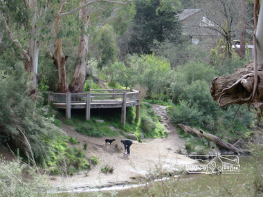
Photograph, Shire of Nillumbik World War One Memorials tour, 10 August 2016, 10 August 2016
Memories Memories of a boyhood's day. When he went to scahool away Letters in a schoolboy's hand. telling of the things he's planned, Linned in colours bright and fair - THESE - are what I have to-night. Visions of a soldier-led, In his dress of khaki clad, Saying, "Mohter, do not grieve." When he has his final leave. His dear face, and my dimmed signt THESE - are what I have to-night. R.M. Conway, Christmas Hills From the Eltham and Whittlesea Shire Advertiser and Diamond Creek Advocate, 13 December 1918. As part of a program to acknowledge the Anzac Centenary Nillumbik Shire Council partnered with Yarra Plenty Regional Library to provide a bus tour with commentary of local sites of significance. These included Eltham township, the Shire of Eltham War Memorial at Kangaroo Ground, Christmas Hills, Hurstbridge memorial recreation park and finished at Eltham Library to view the Writing the War exhibtion at Eltham Library Community Gallery. In May 2015 Nillumbik Shire Council received Anzac centenary Local Grants Program funding for the restoration and enhancement of Christmas Hills cenotaph as a project to commemorate the First World War. Born Digitalworld war 1, war memorials, shire of nillumbik, christmas hills, interpretative signage, poem, "r.m. conway" -
 Eltham District Historical Society Inc
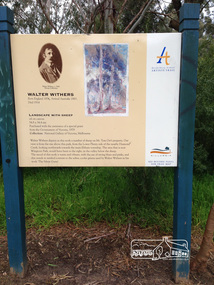
Photograph, Peter Pidgeon, Landscape with sheep by Walter Withers part of the Heidelberg Artist Trail, 2 Sep 2017
The Heidelberg School Artists Trail was established in about 1999 with about 52 signs across four local governemnt areas including Nillumbik and Banyule. This one acknowledges "Landscape with Sheep" by Walter Withers. The text on the board states: Walter Withers depicts in this work a number of sheep on Mr. Tom Orr’s property. Our view is from the rise above this park, from the Lower Plenty side of the nearby Diamond Creek, looking northwards towards the main Eltham township. The area that is now Wingrove Park, would have been to the right, in the valley below the sheep. The mood of this work is warm and vibrant, with the use of strong blues and pinks, and this stands in marked contrast to the softer, cooler greens used by Walter Withers in his work ‘The Silent Gums’. Heritage Excursion by EDHS members - An Eltham South Ramble, 2 Sep 2017Born Digitalactivities, eltham district historical society, eltham south, heritage excursion, local history centre, eltham, heidelberg artists' trail, walter withers, landscape with sheep, wingrove park trail -
 Kiewa Valley Historical Society
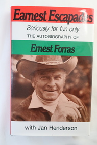
Book - The Autobiography of Ernest Forras, Earnest Escapades Seriously for fun only The autobiography of Ernest Forras with Jan Henderson
Ernest migrated from Hungary in January 1951 and helped bring commercial development to Australia's fledgling snowfields. He was keen to find Alpine employment, eventually importing ski and sports gear. This book covers his time in Hungary and his visits to the Alpine Ski Resorts - an insight into the early years of skiing in Australia.Ernest visited Falls Creek on the Bogong High Plains in 1951 and describes the area on pages 66 to76 from the point of view of an Hungarian migrant. He visited Falls Creek because his brother had got work on Kiewa Hydro Electric Ssheme.Hard dark brown cover book with dust cover coloured in red, white and green with title in black and a photo of Ernest Forras below. It consists of 190 pages. After page 54 and between Part one and Two, there are 18 pages of photos on photographic paper.Written in shaky writing on inside first page "To Debbie / From Hungary With Love / Ernest Forras 2002 / Mt Beautyernest forras, australian ski resorts from 1951, hungary pre 1951 -
 Kiewa Valley Historical Society
Book - Non Fiction History, The Kiewa Story, circa 1993
This book provides in chronological order the development of the Kiewa Hydro-electricity scheme from the first concept (1911) to final construction work (1961). It covers the first attempt to utilise the power of the Victorian Alps water system. It started from a private syndicate and developed to the current State Electricity Commission of Victoria. The incentive for the Hydro scheme was to make money and not as an alternative to the carbon producing coal fired power plants. These coal fired power plants were increasing in numbers to service an ever increasing demand made by population expansion, especially in cities and large rural settlements. This demand spiraled up after World War II when there was a tremendous spike in immigration numbers due to refugees and displaced persons in Europe. The ability to utilise the untapped water provided by the winter snow fields, for a higher yield in electricity, was a powerful incentive to overcome the physical hardships in this remote Alpine region. Future power requirements may initiate the re-installation of the other two power stations(Pretty Valley and Big Hill) covered in original Scheme. This publication not only covers the development of the Kiewa Valley region with respect to population (within a socio-economical framework) but also the subtle but yet strong physical changes of a relatively pristine alpine region. The demands that an ever growing regional population places on the environment is clearly documented in print and black and white photographs. The working and living conditions of those who constructed and gave life to this hydro scheme is well documented in this book. It may be viewed as spartan now but was relevantly good at that moment in time, especially for those workers fleeing a devastated European environment. The successful planning and consideration to minimising any intrusion upon the natural alpine forests and high plains can viewed as an example (compared to the Tasmanian Hydro schemes) of how future hydro schemes (an inevitable requirement) will proceed. Most rural towns (in the early 1900s) were built by unencumbered rural based citizens, with the exception of Mount Beauty and Falls Creek. These two settlements were brought into life by a State (Victorian) Authority for a specific function and program. They were a gated community, that is, only open to construction workers involved with the hydro scheme. All facilities within these communities were provided by the State Electricity Commission of Victoria. The impact on the social, financial and individual independency of the community, by the transition from the S.E.C .environment to one of local government (Shire of Bright), had in some cases a severe impact.This hard covered book has a green cover with pictures on the front and back covers. The front cover has a coloured picture of a snow covered Mount Bogong taken from the opposite mountain range. The valley between both ranges has a whisk of mist over it. At the bottom of this picture are three black and white photographs covering the construction of the Kiewa Hydro - Electricity Scheme. On the back cover is a photograph, (black and white) detailing the Bogong village and Junction dam containing lake Guy. The inside front cover is a black and white photograph which details the construction of the West Kiewa tailrace tunnel during April 1951. The inside back cover is a black and white photograph of the concrete pour at the Clover Dam circa 1952. All photographs and sketches are in black and white. The pages are approximately 160 g/m2 and those which have photographs are on gloss paper.Book spine: "The Kiewa Story Graham Napier Geoff Easdown" alongside this is a white framed circle with white spokes radiating out and underneath in white lettering SECkiewa valley, hydro scheme, victorian alpine region, electricity generators, graham napier, geoff easdown -
 Eltham District Historical Society Inc
Photograph, Entrance to Shire of Eltham Memorial Park, Garden Hill, Eltham-Yarra Glen Road, Kangaroo Ground, c.1923
View to south-east from Shire of Eltham Soldiers' Memorial Park showing the carriageway from the road to top of Memorial Park. Accompanying notes state that the entry gate was put in place in May 1921. Eltham and Whittlesea Shire Advertiser and Diamond Creek Valley Advocate Fri 21 May 1920 p 2 reported: Kangaroo Ground Memorial Park "It was decided to arrange for a working bee on Saturday, 29th inst., for the purpose of forming and gravelling the track leading to the Park, and of carrying out other necessary works." A history summary of the Shire of Eltham Soldiers’ Memorial Park • The summit at Garden Hill was a popular tourist lookout and picnic spot from the 1880s. Virtually the entire Shire of Eltham and beyond could be viewed from this location. • A local farmer, Mr Walter A. D. Wippell is credited as being the first to propose the idea of a war memorial park and offered £50 towards the purchase of the land. • The earliest public reference to this project is to be found in the local Advertiser newspaper edition of August 9th, 1918. A report of the August Council meeting records the Eltham Shire President, Cr. Robert White, saying: "some time back it was proposed that the Council obtain and place on an Honour Board in the Council Chamber [at Kangaroo Ground] containing names of the lads who had enlisted. Just recently however, it had been suggested that a more fitting memorial would be the obtaining of a piece of land on the summit of Garden Hill, Kangaroo Ground, and the formation of a memorial park in which a monument could be erected to represent the whole of Shire. If a couple of acres could be obtained a gentleman had promised to donate 50 pounds, and another one would fence it, and other contributions, he was sure, could be obtained." • Councillors were favourable of the proposal and the President, Shire Secretary and Shire Engineer were deputised to wait on Messrs Mess Bros. (the owners of the Garden Hill farm) and ascertain if they would gratuitously give the land. The Mess Bros. land adjoined the farm/stud of Mrs Fanny White (Cr Robert White’s mother), daughter of Andrew Harkness who established their property on Garden Hill around 1846. • Access to the land came in February 1919 when several Councillors and the Shire Engineer surveyed the actual two acres of '5 chains along the road and 4 chains deep'. The Engineer volunteered his services free to do this task. The Mess brothers however demanded £100 per acre but eventually agreed to take £50 per acre. • Entry from the Kangaroo Ground-Yarra Glen road was seen to be a problem and Mrs. White, who owned the land beside the park, was asked to donated a triangle of her property to allow this access. • By September 1919 returned soldiers were employed by the Shire and volunteers were called to clear the hilltop by ploughing up the rocks and clearing the area, the fencing was put into place and in May 1921 the Council erected three gates, within an archway, at the entrance to the drive and pathway to the summit. • Public subscriptions were sought through the Advertiser newspaper to beautify the site. The views of the Curator of the Melbourne Botanical Gardens were sought as to the ‘class of ornamental trees most suitable for planting in the Park area”. • The Memorial Park or Shire of Eltham Soldiers’ Memorial Park was officially opened by Mr. W.H. Everard, M.L.A., 3 September 1921. • In 1922 plans were made to place a War Memorial in the Park. Funds were donated by the Council of £250 and a challenge to the community, to match this money with contributions was met. • On Anzac Day 1923, 1,000 people gathered on the summit in the park for a memorial service. A much smaller group of about 50 people gathered around a newly constructed cairn and flagstaff in the afternoon of Anzac Day 1924 amidst rain and a squally southerly wind, the morning service being cancelled. • A meeting for those interested in establishing a War Memorial monument within the park was held in January 1924 and the Eltham Shire War Memorial League was formed and a design competition decided upon. • The Shire of Eltham War Memorial tower was built in 1926 at a cost of £1,023 and 5 shillings with locally quarried stone donated by Dr Ethel and Professor William Osborne. It was formally known as the ‘Shire of Eltham War Memorial’ and was unveiled on 11 November 1926. The large bronze inscription above the entrance to the tower states: SHIRE OF ELTHAM WAR MEMORIAL THESE MEN DIED FOR THEIR COUNTRY 1914 IN REMEMBRANCE THIS TOWER WAS BUILT 1918 • The Caretaker’s hut was built in 1927 with left over from the tower construction. • A returned soldier was appointed to act as caretaker for the memorials. Tiny Carrol, a huge man, was the first caretaker and lived in the stone hut. There was a push to have alterations made at one stage to provide additional rooms for a married caretaker but was rejected. • A new Caretaker Cottage was built in 1951 at a cost £2,500. The cottage had been subjected to raids by thieves three times during construction until a guard from the Returned Servicemen’s League was posted until its opening. • The War Memorial tower was re-dedicated by Sir Dallas Brooks on 8 November 1951, unveiling new bronze plaques containing the names of those who fell during the Second World War. Sir Dallas also officiated the opening of the new Caretaker’s Cottage. • A toilet block was built in 1965. • A further dedication of the Shire of Eltham War Memorial tower took place 11 November 2001 to recognise the men who fell in subsequent campaigns up to and including Vietnam. • Four land titles are involved: o The purchase of the two acres from owners Ruth Gosling, Alexander Mess, James Johnson Mess and Joseph Mess is recorded in two actions, the first being the payment of £100 for the two acres, the second showing that the Shire of Eltham did not get a transfer of title until 14th January 1952. o The access land donated by Mrs. Fanny White is dated 26 February 1924. A further need to widen the entry came after the deepening of the road cutting and another land donation was given by Sir Herbert Gepp, title dated 15th May 1952. This would have been about the time he sold off the former White ‘Garden Hill’ property. o The land reserve to increase the area and possibly allow a circuit road to be put in place on the western side of the park was purchased by the Shire of Eltham, title dated 16th February 1973. Rare photograph of the entrance to the Shire's Memorial Park during early stages of development prior to the erection of the Shire of Eltham War MemorialSepia photograph printed with white border with slight crack lower left hand corner and three significant vertical cracks fanning from lower centre edge to upper edge Digitally enhanced version to minimise impact of crackseltham-yarra glen road, entrance gate, garden hill, kangaroo ground, shire of eltham memorial park, shire of eltham war memorial, kangaroo ground war memorial park -
 Eltham District Historical Society Inc
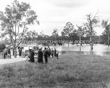
Photograph, Main Road, Eltham South, corner of Falkiner Street, flooded by the Diamond Creek, 1934
... View of the Diamond Creek flooding across Main Road looking... melbourne View of the Diamond Creek flooding across Main Road ...View of the Diamond Creek flooding across Main Road looking towards Eltham at intersection with Falkiner Street; a Council truck blocking Main Road, Eltham Lower Park on right, Eltham Park Tea Rooms (later Ansell and Muir) on left fooded. The bridge can just be seen on far right centre.Black and white photographmain road, eltham south, ansell and muir, diamond creek (creek), eltham park, eltham park tea room, falkiner street, floods, floodwater -
 Eltham District Historical Society Inc
Newspaper - Newsclipping, Nillumbik Mail, "A Memorial Avenue of Honour", A Journey in Time: A column about Nillumbik's history, Nillumbik Mail, 24 May 2000, p4, 2000
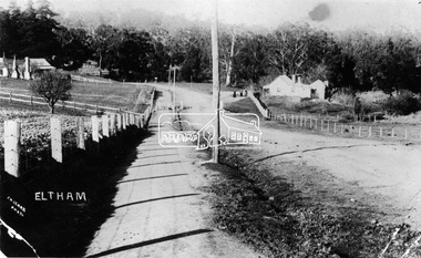
Main Road, Eltham, south from Brougham Street to Dalton Street, c.1911 View looking down Policeman’s Hill on Maria Street (Main Road) from near Brougham Street towards Dalton Street, site of the Avenue of Honour established in 1916-1917 in memory of the soldiers who served in the First World War, 1914-1918. At the bottom of the hill on the right is White Cloud Cottage, home of the Jarrold family, three women standing out front observing the photographer. The road passes over a culvert which runs to the west in front of the cottage. The cottage was originally located closer to the Diamond Creek but was subject to flooding. It was dragged by horse to the present site shown, which was chosen for the higher ground that had been created as a result of land fill being deposited here from the quarry further around the bend on Main Road (site of present-day Eltham Primary School carpark) where the stone had been quarried for building the State School in Dalton Street. Immediately at the end of the straight section of the main road can be seen the gas streetlamp in front of the Jarrold home and the pond at the bottom of Dalton Street. The cottage had previously been rented for use as a Police Station / residence prior to the building of the permanent police house and station at the corner of Maria and Brougham streets in 1859. At the time of collection of photos for the centenary of the Shire of Eltham (1971) the cottage was owned by the Skipper family and remains in the family to present day (2021). On the left is the Grant house on the corner of Main Road and Dalton Street now the present-day site of Eltham Clinic. Photographer: J.H. Clark John Henry Clark was the youngest of three boys born to William Henry Clark (1823-1877) and Maria White (1843-1914). He and his brothers, William Charles Clark (1872-1945), Clement Kent Clark (1874-1912) operated a photography business (Clark Bros.) from 25 Thomas Street, Windsor near Prahran during the period c.1894 to 1914. Following death of Clement in September 1912 and their mother in 1914, the Clark Bros business appears to have dissolved, the premises demolished, and a new house was under construction in 1915. John set up business independently in 1914 operating out of 29 Moor Street, Fitzroy where he is registered in the 1914 and 1915 Electoral Rolls. By 1916 John had relocated to Eltham where he continued his practice as a photographer and took many of the early images around the district of Little Eltham. Around 1930 John changed professions and opened a small cobbler's shop in 1931 near the pond opposite Dalton Street adjacent to the Jarrold family cottage. He never married and continued his profession as a bootmaker from this little shop, maintaining a close relationship with Mrs Jarrold for the rest of their lives. His bootmaker shop remains today beside the Whitecloud cottage and is one of only three remaining shops in the area from the early 20th century. There are a couple of images of Eltham taken by Clark Bros. in the Eltham District Historical Society collection, one such example being Hunniford’s Post Office with Miss Anne Hunniford out front (EDHS_00140 - marked on the back of the print, Clark Bros., 25 Thomas St. Windsor), which would date this image between c.1894 and 1914. Other early images of Eltham taken by John Henry Clark are marked on the face “J. H. Clark Photo” and it is assumed these are dated between 1914 and 1930. It is noted that the Grant of Probate for John H Clark of Eltham South dated 5 April !957 (513/387) records his occupation as "X Photographer".Newsprint pageNillumbik Mail publication details; Edition 4, 24 May 2000, p4dalton street, avenue of honour, eltham clinic, gas lamp, grant house, j.h. clark photo, jarrold cottage, jarrold family, main road, shire of eltham pioneers photograph collection, white cloud cottage -
 Eltham District Historical Society Inc
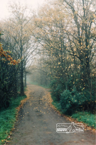
Photograph, Diamond Creek Trail, Eltham
... Colour photograph of Autumn view of Diamond Creek Trail... melbourne dalton street walkways Colour photograph of Autumn view ...Colour photograph of Autumn view of Diamond Creek Trail opposite Dalton Street west of Main Roaddalton street, walkways -
 Eltham District Historical Society Inc
Photograph, Old Bridge, Kaylock's Crossing, Brougham Street, Eltham, c.1895
Brougham Street was created in Josiah Holloway's 1851 subdivision of Little Eltham. It was one of several east-west streets shown on the subdivision plan as crossing the Diamond Creek. The western part was named Wellington Street on the subdivision plan but was later changed to conform with the name of the eastern part as acknowledgement of the continuity of the street. It is not known when the first bridge was constructed in Brougham Street however it was certainly mentioned at Council’s meeting of 2 June 1884 as being in a dangerous state of repair. This photo (c.1895) of an old bridge shows a very low-level simple log girder bridge crossing the creek at a right angle and so the approaches involved bends in the road alignment. This bridge was generally known as Kaylocks Bridge or Kaylock’s Crossing after the owner of the adjoining land. It was most likely built from around the mid-1850s, or a crossing of some fashion established as Richard George Kaylock, butcher of Little Eltham and his wife Emily Ann settled there in 1854. His property was in Wellington Street (now Brougham Street) and apparently extended across the Diamond Creek. The land on the western side of the creek was farmed, the house being on the eastern side. Kaylock's Bridge formed part of the original coach road to Eltham and in 1922 was described as an "old rustic bridge". Its low level and insubstantial construction made it susceptible to flood damage, necessitating frequent closures until repairs could be carried out. In September 1922, Council called for tenders for a new timber bridge to be constructed at Kaylock’s crossing. An engineering assessment carried out for the Council by Macleod Consulting at the time of the replacement suggested that the construction details indicate that it was in the 1900s, however this dating could possibly have been the result of numerous repairs undertaken over the years to flood damage. The tender was awarded to Mr Weller of Kangaroo Ground who commenced work in February 1923 on a higher-level timber trestle bridge. Work was slowed due to illness of the contractor and the accidental death of a man in March 1923 following the collapse of the bank after he had jumped into a hole that had just been blasted. The bridge was completed around July 1923 at which point the old structure was pulled up, marking what was described in the ‘Advertiser’ newspaper as the passing of an old and well-loved landmark in the district. In April 1924 the approach to Kaylocks bridge was washed away during the heavy flooding that destroyed the Main Road bridge. The western side was repaired, and an extra span was added to the eastern side using timber from the destroyed Main Road bridge. The bridge was again severely damaged four months later in August 1924 When a lack of finances delayed repairs to the Bridge Street bridge in 1931 (also referred to as Obelisk Bridge at the time), traffic had to detour via Brougham Street for some time. Local residents feared that the Bridge Street bridge might never reopen. Kaylocks Bridge was constantly subject to damage by floods. In the 1934 flood it was submerged by two feet of water. In more recent times the bridge was again severely damaged by flooding and repairs made. A new bridge and adjoining footbridge were constructed in 2009. Part of a slide show presentation "Bridges & Waterways of the Shire" by Russell Yeoman to the 13 September 1989 Society meeting. The presentation included slides of historic photos from the Shire of Eltham Pioneers collections as well as several recent views.Photo of earliest known crossing of the Diamond Creek at brougham StreetPostcard photo printbrougham street, eltham, wellington street, kaylocks bridge, bridge, diamond creek (creek) -
 Eltham District Historical Society Inc
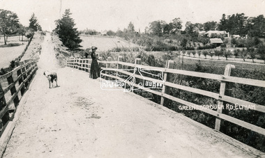
Photograph, Bridge over the Diamond Creek, Greensborough Road, Eltham, c.1885
Original (1874) bridge in Bridge Street, Eltham looking east over the Diamond Creek towards Maria Street (Main Road) at Little Eltham. In the distance to the right on Maria Street is the Methodist Church (1881), now Uniting Church, and the adjacent Commercial Bank of Australia branch building (1878). Part of a slide show presentation "Bridges & Waterways of the Shire" by Russell Yeoman to the 13 September 1989 Society meeting. The presentation included slides of historic photos from the Shire of Eltham Pioneers collections as well as several recent views.Photo of original 1875 timber and gravel surface bridge over the Diamon Creek in Bridge Street with views of orchards representative of the farming lands as well as the development along the northern end of Maria Street.Black and white photograph copybridge street, bridge street bridge, cba bank, diamond creek (creek), eltham, little eltham, main road, maria street, methodist church, uniting church -
 Eltham District Historical Society Inc
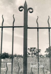
Photograph, George W. Bell, Gateway Diamond Creek Cemetery, 1965, 1965
... Black and white photograph of view of Diamond Creek... collection Black and white photograph of view of Diamond Creek ...Black and white photograph of view of Diamond Creek Cemetery through wrought iron gate 1965cemeteries, diamond creek, nillumbik cemetery, george w bell collection -
 Eltham District Historical Society Inc
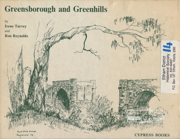
Book, Irene Turvey et al, Greensborough and Greenhills / words by Irene Turvey ; Drawings by Ron Reynolds, 1973
Pen and ink sketches accompanied by appropriate text in double page spreads. Contents cover : Blue stone bridge, Introduction, House cnr Church and Hailes Street, House - 25 Hailes Street, Yandell Reserve, Greensborough Hotel, Lobb's Kiosk, House - 49 Grimshaw Street, View of Greensborough (from Delphin Crescent), Railway Station, Old Barn (near Greensborough Railway Station), Partington's Flat and River Valley, Rand Street Bridge, Lower Main Street, Greenbriar Nursery, Hitching rail, Ashmead - Dr Cordner's Home, Greensborough Primary School, House - cnr St Helena and Diamond Creek Raods, Sondermeyer's Hill, Methodist Church, Football Pavilion, Cemetery, St Katherine's Church, St. Helena, Civic Centre, Briar Hill Timber Mill, 24 River Street, Kelly's Garden Supplies, 158 Main Street, Old Swimming pool, 105 Main Street.Hardback; 62 p. : ill., map ; 19 x 25 cm.ISBN 0909807108 Signed by author and illustrator Two copiesgreenhills, greensborough -
 Eltham District Historical Society Inc
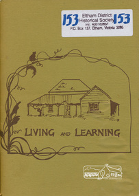
Book, Clipper Press, Living and Learning, 1977
Shire of Eltham Living and Learning Centre is located at 739 Main Road, Eltham. The purpose of the Centre is: To provide an opportunity to come together individually and in groups in an atmosphere of equality, sharing their skills and experiences in order to improve the quality of their living. Tutors are not paid and fees are not charges on the understanding that the idea of sharing and co-operating spreads and everyone enjoys the results. This book was compiled by volunteers involved at the centre recording feelings, views of their experiences within the groups at the centre. It includes recipes, poems, stories and sketches, some of local scenes. It also includes an early history of the Centre compiled by the first Co-ordinator. Subjects include enrolment day, bee keeping, Bridge Club,Carpentry and woodcarving, looking and sharing, creative dancing, crochet, dressmaking, film making, Friends of the Creek, Diamond Creek, accessibility, hair cutting, herb gardening, home handyman skills, homestead cooking, living with goats, native plants, North Riding Project, gardening, painting, playhouse, play reading, puppetry, sculpture, spinning, weaving, winemaking and yoga. This book is significant in documenting the early history of the Eltham Living and Learning centre including the concepts of community co-operation and life-long learning for adults. It connects the current users of the Centre and the wider community with this local history which is part of the character represented in the twentieth century history of the Eltham area. Softcover [64] p.eltham living and learning centre, co-operative, education -
 Eltham District Historical Society Inc
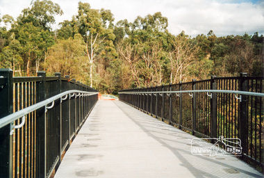
Photograph, Doug Orford, Completion of bridge works across Yarra River at rear of Eltham Lower Park, July 2004, July 2004
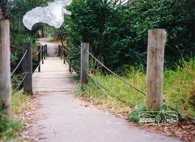
Brand new Eltham-Templestowe footbridge over the Yarra River off Homestead Road, Eltham which was completed in July 2004. The Yarra River Footbridge was opened in August 2004 and links the Diamond Creek Trail between the Shire of Nillumbik and City of Manningham. It is a shared pathway and also links with the Main Yarra Trail. It affords lovely views over the Yarra River.One of three colour photographs.yarra river, eltham south, eltham lower park, lenister farm, homestead road, shared pathway, diamond creek trail, footbridge -
 Eltham District Historical Society Inc
Photograph, Doug Orford, Diamond Creek Trail, Eltham
Two colour photographs showing view looking towards and entering footbridge on the Diamond Creek Trail, Elthamwalkways, bridges, diamond creek, eltham, alistair knox park -
 Eltham District Historical Society Inc
Photograph, Doug Orford, Diamond Creek Trail, Eltham
Two colour photographs showing view looking towards and entering footbridge on the Diamond Creek Trail, Elthamwalkways, bridges, diamond creek, eltham -
 Eltham District Historical Society Inc
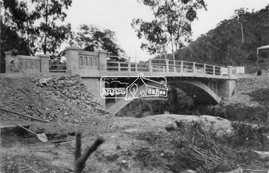
Negative - Photograph, New bridge at Hurstbridge, 1917
The newly constructed re-inforced concrete arched bridge across the Diamond Creek at Hurstbridge designed by John Monash. Eltham Shire shared the cost of the construction of the bridge with Heidelberg and Whittlesea Shires. The bridge was officially opened on 3rd November 1917. Part of a slide show presentation "Bridges & Waterways of the Shire" by Russell Yeoman to the 13 September 1989 Society meeting. The presentation included slides of historic photos from the Shire of Eltham Pioneers collections as well as several recent views.This photo forms part of a collection of photographs gathered by the Shire of Eltham for their centenary project book, "Pioneers and Painters: 100 years of the Shire of Eltham" by Alan Marshall (1971). The collection of over 500 images is held in partnership between Eltham District Historical Society and Yarra Plenty Regional Library (Eltham Library) and is now formally known as 'The Shire of Eltham Pioneers Photograph Collection.' It is significant in being the first community sourced collection representing the places and people of the Shire's first one hundred years.Digital image 4 x 5 inch B&W Negshire of eltham pioneers photograph collection, hurstbridge, bridge, 1917, diamond creek (creek), monash bridge -
 Eltham District Historical Society Inc
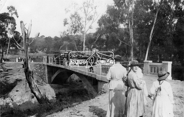
Negative - Photograph, Opening of the new bridge at Hurstbridge, 1917
The opening ceremony of new the bridge over the Diamond Creek at Hurstbridge, designed by Sir John Monash. The single arch concrete bride replaced the original wooden structure erected in 1881. People gathering around 3pm for the Official Opening of Hurst's Bridge, 3 November 1917. View of steam train at Hurstbridge Railway Station in distance. Part of a slide show presentation "Bridges & Waterways of the Shire" by Russell Yeoman to the 13 September 1989 Society meeting. The presentation included slides of historic photos from the Shire of Eltham Pioneers collections as well as several recent views. 1917 'HURST'S BRIDGE.', Eltham and Whittlesea Shires Advertiser and Diamond Creek Valley Advocate (Vic. : 1917 - 1922), 9 November, p. 3. (MORNING.), viewed 28 Jul 2018, http://nla.gov.au/nla.news-article57641838This photo forms part of a collection of photographs gathered by the Shire of Eltham for their centenary project book,"Pioneers and Painters: 100 years of the Shire of Eltham" by Alan Marshall (1971). The collection of over 500 images is held in partnership between Eltham District Historical Society and Yarra Plenty Regional Library (Eltham Library) and is now formally known as the 'The Shire of Eltham Pioneers Photograph Collection.' It is significant in being the first community sourced collection representing the places and people of the Shire's first one hundred years.Digital image 120 format B&W negativesepp, shire of eltham pioneers photograph collection, diamond creek, hurstbridge, wattle glen, bridge, mia mia, opening day, sir john monash -
 Eltham District Historical Society Inc
Negative - Photograph, The Bridge, Hurstbridge, Vic, c.1925
Copied from brochure "Wattle Valley Estate" 7 minutes from the bridge. The new bridge designed by Sir John Monash over the Diamond Creek near Hurst's home of 'Mia Mia' at Hurstbridge. The Wattle Valley Estate was first advertised in August 1925 as weekend building allotments by the Greater Melbourne Land and Development Company. Advertised from £28.10.0 or £60 per block. In August 1926, 30 picked allotments of 60x150 feet were put up for auction Saturday August 14, 1926 with frontages to Valley View Road and Fawkner Crescent advertised in the “Heart of the Glorious Wattle Country” and “Within 15 Minutes of the Newly Electrified Railway Station”. The Advertiser on August 13, 1926 in an article promoting the auction stated “the estate is regarded as one of the best in the district, and will be sold practically without reserve.” It is noted that an advertisement running in The Argus February 22, 1951 offered the remaining 16 blocks for sale at £12.10.0 or £200 the lot. By March 7, the remaining blocks were advertised at £17.10.0 The Wattle Valley Estate took over 20 years to sell and then people could not build on them This image was also used in a brochure advertising the "Wattle Valley Estate", which forms part of the Shire of Eltham Pioneers Photograph Collection (Cross Reference Photo No.(s): 1056, 1057)This photo forms part of a collection of photographs gathered by the Shire of Eltham for their centenary project book,"Pioneers and Painters: 100 years of the Shire of Eltham" by Alan Marshall (1971). The collection of over 500 images is held in partnership between Eltham District Historical Society and Yarra Plenty Regional Library (Eltham Library) and is now formally known as the 'The Shire of Eltham Pioneers Photograph Collection.' It is significant in being the first community sourced collection representing the places and people of the Shire's first one hundred years.Digital image 4 x 5 inch B&W Negshire of eltham pioneers photograph collection, hurstbridge, bridge, diamond creek (creek), monash bridge, wattle valley estate -
 Eltham District Historical Society Inc
Negative - Photograph, Rose Stereograph Company, The Bridge, Hurstbridge, Vic, c.1925
Copied from brochure "Wattle Valley Estate". The new bridge designed by Sir John Monash over the Diamond Creek near Hurst's original home "Mia Mia" seen in the distance. Reprinted from brochure advertising "Wattle Valley Estate" 7 minutes from bridge. The Wattle Valley Estate was first advertised in August 1925 as weekend building allotments by the Greater Melbourne Land and Development Company. Advertised from £28.10.0 or £60 per block. In August 1926, 30 picked allotments of 60x150 feet were put up for auction Saturday August 14, 1926 with frontages to Valley View Road and Fawkner Crescent advertised in the “Heart of the Glorious Wattle Country” and “Within 15 Minutes of the Newly Electrified Railway Station”. The Advertiser on August 13, 1926 in an article promoting the auction stated “the estate is regarded as one of the best in the district, and will be sold practically without reserve.” It is noted that an advertisement running in The Argus February 22, 1951 offered the remaining 16 blocks for sale at £12.10.0 or £200 the lot. By March 7, the remaining blocks were advertised at £17.10.0 The Wattle Valley Estate took over 20 years to sell and then people could not build on them This image was also used in a brochure advertising the "Wattle Valley Estate", which forms part of the Shire of Eltham Pioneers Photograph Collection (Cross Reference Photo No.(s): 1056, 1057). Also cross reference SEPP_1028 / 29 for other views of Mia Mia. Part of a slide show presentation "Bridges & Waterways of the Shire" by Russell Yeoman to the 13 September 1989 Society meeting. The presentation included slides of historic photos from the Shire of Eltham Pioneers collections as well as several recent views. This photo forms part of a collection of photographs gathered by the Shire of Eltham for their centenary project book,"Pioneers and Painters: 100 years of the Shire of Eltham" by Alan Marshall (1971). The collection of over 500 images is held in partnership between Eltham District Historical Society and Yarra Plenty Regional Library (Eltham Library) and is now formally known as the 'The Shire of Eltham Pioneers Photograph Collection.' It is significant in being the first community sourced collection representing the places and people of the Shire's first one hundred years.Digital image 4 x 5 inch B&W Negshire of eltham pioneers photograph collection, hurstbridge, mia mia, bridge, diamond creek (creek), monash bridge, wattle valley estate -
 Eltham District Historical Society Inc
Negative - Photograph, Popular Picnicing at Hurstbridge, c.1925
Picnickers enjoying a Sunday outing near the Wattle Valley Estate at Hurstbridge. Copied from brochure "Wattle Valley Estate". It is believed the picture is taken at the northwest corner of the intersection of Wattletree Road and Hurstbridge-Arthurs Creek Road looking southeast towards the township (most likely where the house is located on the property of what is today No. 2 Wattletree Road)- https://goo.gl/maps/VDorwCe1rJJUapjE6 According to a comment by Jean Verso (via @nillumbikcouncil FB page 3 Jan 2020) - "This view is from Wattle Tree Road with Haleys Gully Road to the right and across the creek to William Gray's nursery at Allwood. The building to the far left looks like Dorset House. The building on the left in the middle distance is still there today and has been used for storage and as a stable/tack room for a number of years." The Wattle Valley Estate was first advertised in August 1925 as weekend building allotments by the Greater Melbourne Land and Development Company. Advertised from £28.10.0 or £60 per block. In August 1926, 30 picked allotments of 60x150 feet were put up for auction Saturday August 14, 1926 with frontages to Valley View Road and Fawkner Crescent advertised in the “Heart of the Glorious Wattle Country” and “Within 15 Minutes of the Newly Electrified Railway Station”. The Advertiser on August 13, 1926 in an article promoting the auction stated “the estate is regarded as one of the best in the district, and will be sold practically without reserve.” It is noted that an advertisement running in The Argus February 22, 1951 offered the remaining 16 blocks for sale at £12.10.0 or £200 the lot. By March 7, the remaining blocks were advertised at £17.10.0 The Wattle Valley Estate took over 20 years to sell and then people could not build on them Cross Ref EDHS_02665 Rose Series Postcard P. 4341, "View at Hurstbridge, Vic." Also, other images from sales brochure SEPP_1055 / 1056This photo forms part of a collection of photographs gathered by the Shire of Eltham for their centenary project book,"Pioneers and Painters: 100 years of the Shire of Eltham" by Alan Marshall (1971). The collection of over 500 images is held in partnership between Eltham District Historical Society and Yarra Plenty Regional Library (Eltham Library) and is now formally known as the 'The Shire of Eltham Pioneers Photograph Collection.' It is significant in being the first community sourced collection representing the places and people of the Shire's first one hundred years.Digital image 4 x 5 inch B&W Neg1925, dorset house, fawkner crescent, haleys gully road, hurstbridge, hurstbridge-arthurs creek road, picnic, postcards, shire of eltham pioneers photograph collection, valley view road, wattle valley estate, wattletree road, exhibition yprl 2019-12 -
 Eltham District Historical Society Inc
Negative - Photograph, Warrandyte Bridge over River Yarra, c.1910
View of the 1875 timber trestle bridge over the Yarra River reproduced from a newsprint image. Also known as Anderson's Creek (Road) Bridge A contract was accepted for William Elliot to erect a bridge over the Yarra River at Warrandyte on Anderson's Creek Road and other improvements for £1,331.6.2 - Gazette No. 143. Tuesday, November 13th 1860 - http://gazette.slv.vic.gov.au/view.cgi?year=1860&class=general&page_num=2161&state=V&classNum=G143&id=). The bridge was washed away by floods in 1863. It was replaced with a taller timber trestle structure in October 1875, designed and built by C.S. Wingrove, Shire Clerk, Engineer and Surveyor for Eltham Shire Council. A replacement for this bridge was commenced in 1955 to cope with increasing traffic and this structure was widened in 2018 to meet further traffic demands. Argus (Melbourne, Vic. : 1848 - 1957), Thursday 23 September 1875, page 7 ________________________________________ THE WARRANDYTE BRIDGE. The ceremony of formally opening the newly erected bridge over the Yarra at Ander-son's Creek was performed on Monday last, in the presence of the members of the Eltham and Bulleen shire councils whose territories it joins, and a goodly number of the residents of the district. The task was delegated to Mr. Cameron, M.L.A., who, after a few introductory remarks declared the bridge to be opened, and christened it the " Warrandyte Bridge." The party then adjourned to Grant's Hotel, where a cold collation had been prepared. The chair was taken by the president of the Eltham shire (Mr. John Bell) and the vice chair by Mr. Kent, a member of the Bulleen council. Mr Robert Williamson proposed "Success to the bridge," coupling with it the name of Mr. Cameron, to whose exertions was in the main to be attributed the erection of that structure which was an ornament to the district and would prove of great service to both sides of the river. Mr. Cameron, in responding, alluded to the great difficulties, mainly of a pecuniary nature, that had been encountered in carrying out the project, and which had only been got over by their united efforts and by the liberal spirit in which the late Commissioner of Roads had dealt with the case. The healths of the contractor and the engineer were also drunk. The bridge is a trussed timber one, resting on yellow box piles sunk into the solid rock, each pier being weighted with 50 tons of stone. The abutments consist of dry stone walls, 6ft. thick at the base, and tapering to 3ft. on the top, the face of the work having a batter of 1 to 1. The length of the bridge is 308ft., there being four openings in the centre of 66ft. each, and two at the ends of 20ft. each. The width in the clear is 9½ft., and the height from the bed of the river about 33ft. The approaches comprise 1,100 cubic yards of earthwork, and the formation of 48 chains of sideling, the whole cost of the work, which was carried out under the direction of the engineer to the Eltham Shire Council, being £1,413.This photo forms part of a collection of photographs gathered by the Shire of Eltham for their centenary project book,"Pioneers and Painters: 100 years of the Shire of Eltham" by Alan Marshall (1971). The collection of over 500 images is held in partnership between Eltham District Historical Society and Yarra Plenty Regional Library (Eltham Library) and is now formally known as the 'The Shire of Eltham Pioneers Photograph Collection.' It is significant in being the first community sourced collection representing the places and people of the Shire's first one hundred years.Digital image 4 x 5 inch B&W Neg B&W Print 12.5 x 9 cmsepp, shire of eltham pioneers photograph collection, warrandyte, bridge -
 Eltham District Historical Society Inc
Photograph, View at Eltham, Vic, c.1924
Copy of possible Rose Stereograph Co. postcard “View at Eltham, Vic.”, c.1924 looking southwest from Main Road near York Street to Bridge Street and the original 1875 bridge across what is now the Alistair Knox Park The land in the foreground was first bought from the Crown by J.M. Holloway in 1851. The land was sub-divided and called "Little Eltham". Bridge Street was created as part of the sub-division. Most of the sub-division was residential lots but the creek valley was divided into lots for small farms. Council started to buy the land for the Eltham Town park in the early 1960s. The area was used as a garbage tip and filled above the flood plain of the creek. Development of the land for a park began in the early 1970s. The house on the right was owned for many years by the Hill family until Council bought it in the early 1960s. The house was built in the 1850s or 60s. The house on the left stood on what is now the southwest corner of Susan and Bridge Streets. The Braithwaite family was associated with this house. The double line of fencing in the foreground was a continuation of York Street to the creek. The Bridge Street bridge was built in 1875 and replaced in 1958. (Ref: Early view of Little Eltham; Byways of History by Colleen Ison, Publication unk, 24 August 1982) Reproduced on p61 of 'Pioneers & Painters' Date estimated on same as View at Hurstbridge featuring Wattle Valley EstateThis photo forms part of a collection of photographs gathered by the Shire of Eltham for their centenary project book,"Pioneers and Painters: 100 years of the Shire of Eltham" by Alan Marshall (1971). The collection of over 500 images is held in partnership between Eltham District Historical Society and Yarra Plenty Regional Library (Eltham Library) and is now formally known as the 'The Shire of Eltham Pioneers Photograph Collection.' It is significant in being the first community sourced collection representing the places and people of the Shire's first one hundred years.Digital image 120 format B&W negative Prints 17 x 25 cm and 10 x 15 cmsepp, shire of eltham pioneers photograph collection, eltham, bridge street, bridge, alistair knox park, braithwaite, bridge street bridge, eltham town park, hill family home, main road, pioneers and painters, york street -
 Eltham District Historical Society Inc
Negative - Photograph, J.H. Clark, Main Road, Eltham, south from Brougham Street to Dalton Street, c.1911
Main Road, Eltham, south from Brougham Street to Dalton Street, c.1911 View looking down Policeman’s Hill on Maria Street (Main Road) from near Brougham Street towards Dalton Street, site of the Avenue of Honour established in 1916-1917 in memory of the soldiers who served in the First World War, 1914-1918. At the bottom of the hill on the right is White Cloud Cottage, home of the Jarrold family, three women standing out front observing the photographer. The road passes over a culvert which runs to the west in front of the cottage. The cottage was originally located closer to the Diamond Creek but was subject to flooding. It was dragged by horse to the present site shown, which was chosen for the higher ground that had been created as a result of land fill being deposited here from the quarry further around the bend on Main Road (site of present-day Eltham Primary School carpark) where the stone had been quarried for building the State School in Dalton Street. Immediately at the end of the straight section of the main road can be seen the gas streetlamp in front of the Jarrold home and the pond at the bottom of Dalton Street. The cottage had previously been rented for use as a Police Station / residence prior to the building of the permanent police house and station at the corner of Maria and Brougham streets in 1859. At the time of collection of photos for the centenary of the Shire of Eltham (1971) the cottage was owned by the Skipper family and remains in the family to present day (2021). On the left is the Grant house on the corner of Main Road and Dalton Street now the present-day site of Eltham Clinic. Cross Ref: 0749 for another view of the Jarrold family home Photographer: J.H. Clark John Henry Clark was the youngest of three boys born to William Henry Clark (1823-1877) and Maria White (1843-1914). He and his brothers, William Charles Clark (1872-1945), Clement Kent Clark (1874-1912) operated a photography business (Clark Bros.) from 25 Thomas Street, Windsor near Prahran during the period c.1894 to 1914. Following death of Clement in September 1912 and their mother in 1914, the Clark Bros business appears to have dissolved, the premises demolished, and a new house was under construction in 1915. John set up business independently in 1914 operating out of 29 Moor Street, Fitzroy where he is registered in the 1914 and 1915 Electoral Rolls. By 1916 John had relocated to Eltham where he continued his practice as a photographer and took many of the early images around the district of Little Eltham. Around 1930 John changed professions and opened a small cobbler's shop in 1931 near the pond opposite Dalton Street adjacent to the Jarrold family cottage. He never married and continued his profession as a bootmaker from this little shop, maintaining a close relationship with Mrs Jarrold for the rest of their lives. His bootmaker shop remains today beside the Whitecloud cottage and is one of only three remaining shops in the area from the early 20th century. There are a couple of images of Eltham taken by Clark Bros. in the Eltham District Historical Society collection, one such example being Hunniford’s Post Office with Miss Anne Hunniford out front (EDHS_00140 - marked on the back of the print, Clark Bros., 25 Thomas St. Windsor), which would date this image between c.1894 and 1914. Other early images of Eltham taken by John Henry Clark are marked on the face “J. H. Clark Photo” and it is assumed these are dated between 1914 and 1930. It is noted that the Grant of Probate for John H Clark of Eltham South dated 5 April !957 (513/387) records his occupation as "X Photographer".This photo forms part of a collection of photographs gathered by the Shire of Eltham for their centenary project book,"Pioneers and Painters: 100 years of the Shire of Eltham" by Alan Marshall (1971). The collection of over 500 images is held in partnership between Eltham District Historical Society and Yarra Plenty Regional Library (Eltham Library) and is now formally known as the 'The Shire of Eltham Pioneers Photograph Collection.' It is significant in being the first community sourced collection representing the places and people of the Shire's first one hundred years.Digital image 4 x 5 inch B&W Negshire of eltham pioneers photograph collection, eltham, main road, jarrold family, dalton street, j.h. clark photo, white cloud cottage, avenue of honour, eltham clinic, gas lamp, grant house, jarrold cottage, 1900 -
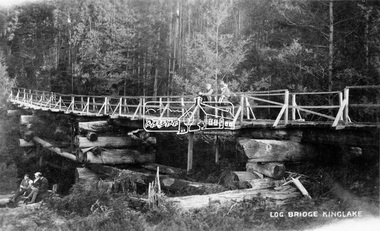 Eltham District Historical Society Inc
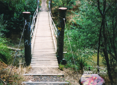
Negative - Photograph, Log bridge over Pheasant Creek, Kinglake, c.1920
Postcard view of pedestrian log bridge in Kinglake National Park. The log bridge over Johnston's Creek is said to have been built to allow the timber tramline to cross the creek. The bridge was destroyed in the 1926 bushfires. Other sources describe this bridge being located at Pheasant Creek (between Kinglake West and Kinglake Central) and that it was built by Mr Munro, the owner of the sawmill.This photo forms part of a collection of photographs gathered by the Shire of Eltham for their centenary project book,"Pioneers and Painters: 100 years of the Shire of Eltham" by Alan Marshall (1971). The collection of over 500 images is held in partnership between Eltham District Historical Society and Yarra Plenty Regional Library (Eltham Library) and is now formally known as 'The Shire of Eltham Pioneers Photograph Collection.' It is significant in being the first community sourced collection representing the places and people of the Shire's first one hundred years.Digital image 4 x 5 inch B&W Neg 1 printshire of eltham pioneers photograph collection, kinglake, log bridge, bridge, mr. munro, timber tramway, pheasant creek -
 Eltham District Historical Society Inc
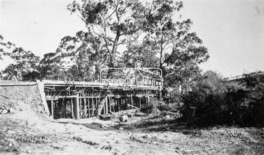
Negative - Photograph, Construction of the new concrete bridge over the Diamond Creek on Main Road, Eltham, c.May 1926
Construction of the new concrete bridge over the Diamond Creek on Main Road, Eltham, c.May 1926. Viewed from present day Wingrove Park. The original long suspension bridge over the Diamond Creek on Main Road at Eltham collapsed during flooding of the Diamond Creek on October 13 and 14, 1923. The original bridge was built around 1840 for the coach road when Cobb & Co.'s coach was the only conveyance between Eltham and Melbourne. Widespread damage was done in Melbourne and surrounding areas by floods resulting from the overflow of the Yarra at many points along its banks. A temporary bridge rigged up was severely damaged by the flooding of the creek and was closed to vehicular traffic in April 1924. A new concrete bridge was constructed to replace it and by May 1926 all the concrete piles and abutments had been completed. The bridge was finally completed and opened for traffic in September 1926, almost three years after it initially collapsed.This photo forms part of a collection of photographs gathered by the Shire of Eltham for their centenary project book,"Pioneers and Painters: 100 years of the Shire of Eltham" by Alan Marshall (1971). The collection of over 500 images is held in partnership between Eltham District Historical Society and Yarra Plenty Regional Library (Eltham Library) and is now formally known as the 'The Shire of Eltham Pioneers Photograph Collection.' It is significant in being the first community sourced collection representing the places and people of the Shire's first one hundred years.Digital image 4 x 5 inch B&W Neg Print 9 x 12.5 cmshire of eltham pioneers photograph collection, eltham, eltham lower park, main road bridge, eltham south, bridge, diamond creek (creek), wingrove park, bridge construction -
 Eltham District Historical Society Inc
Negative - Photograph, Bridge on Main Road, Eltham, c.1890
Possibly produced as a postcard. Caption in lower right hand corner reads: Bridge (at) Main Road Eltham. The long wooden suspension bridge over the Diamond Creek on Main Road at Eltham collapsed during flooding of the Diamond Creek on October 13 and 14, 1923. The original bridge was built around 1840 for the coach road when Cobb & Co.'s coach was the only conveyance between Eltham and Melbourne. Widespread damage was done in Melbourne and surrounding areas by floods resulting from the overflow of the Yarra at many points along its banks. A temporary bridge rigged up was severely damaged by the flooding of the creek and was closed to vehicular traffic in April 1924. A new concrete bridge was constructed to replace it and by May 1926 all the concrete piles and abutments had been completed. The bridge was finally completed and opened for traffic in September 1926, almost three years after it initially collapsed. Viewed from Antoinette Boulevard looking northwest towards Falkiner Street. The building in the distance believed to be Souters Cottage. On the far right on the very edge of the road verge are two Eucalypt trees, one of which is believed to be the large dead trunk still standing in present day.This photo forms part of a collection of photographs gathered by the Shire of Eltham for their centenary project book,"Pioneers and Painters: 100 years of the Shire of Eltham" by Alan Marshall (1971). The collection of over 500 images is held in partnership between Eltham District Historical Society and Yarra Plenty Regional Library (Eltham Library) and is now formally known as the 'The Shire of Eltham Pioneers Photograph Collection.' It is significant in being the first community sourced collection representing the places and people of the Shire's first one hundred years.Digital image 4 x 5 inch B&W Neg Black and white print 35mm positive transparencyshire of eltham pioneers photograph collection, eltham, main road bridge, eltham south, bridge, diamond creek (creek), significant tree, souters cottage, eltham lower park, main road, sepp -
 Eltham District Historical Society Inc
Photograph, Henley Bridge, Spring Excursion, Exploring the Upper Yarra, 22 October 1995, 22/10/1995
[article by Bettina Woodburn in EDHS Newsletter No. 105, November 1995:] EXPLORING THE UPPER YARRA - We enjoyed the Spring Excursion, this year "Exploring the Upper Yarra" - in spite of the constant rain and the countryside under the cloud cover, especially in the valleys, being mainly shiny shades of green. The occasional fields of buttercups, clumps of arum lilies and splendid rhododendron and other flowering bushes became very special. The Cobb and Co coach was warm and a cosy retreat as we zig-zagged on the highways and byways to glimpse the Yarra River, upstream and down, its secret places, and particularly the many bridges. Russell excelled as 'Poet Laureate', reading from Dacre Smyth's book. This 1979 publication includes paintings of all the bridges along the river with poems and brief descriptions of each one. Some of the bridges are in out-of-the-way places and are not very well known. We looked forward to hearing the poetry as much as seeing the 'constructions'… Big Pat (was he short or tall, lean or fat? - he did win the £200 reward for discovering gold and had the creek named after him), about the 'Eddies'?, and the disliked 'meccano' bridge in Warburton, etc. etc. The hot roast lunch in the old Reefton Hotel was also most welcome. It was easy to imagine it peopled by miners and early settlers. Starting by crossing the new (1974) concrete bridge at Warrandyte we headed through Wonga Park with views to the Christmas Hills and to the escarpment of the Yering Gorge, which causes flood waters to back up through the Yarra Glen plain, so avoiding disasters downstream. At the end of a long driveway we found the wooden, privately owned Henley Bridge (1935 after the 1934 floods). This facilitates access to different parts of Henley Farm and to Lilydale. Everard Park, named after Blanche Shallard's father, a State Member for 17 years, below the Highway Yarra crossing was in need of care. It is 10 miles from Yarra Glen by road but, as "Yarra Marra” canoeists well know, 32 winding miles down by water. After more delightful countryside scenes we joined the Warburton Highway at Woori Yallock. From the old Railway Station at Launching Place the Centennial Trail for walkers, cyclists and horse riders has replaced the rails. The line from Lilydale was opened in 1901, and the last diesel freight train ran to Warburton in 1965. It continued to rain as we had morning tea in Warburton in a shelter between footbridges. From here we continued upstream past the Bridge to O'Shannassy Lodge and Reservoir, Starvation Creek, and the Peninsular tunnel (miners dug it as at Pound Bend) which we visited (scrambling down those steps!) on our return after lunch. Our furthermost point was the Upper Yarra Dam Reserve (and vast catchment area). Finished in 1957 after ten years' work and 100 years after Yan Yean, it supplies much of Melbourne's water. After crossing the 30m Launching Place Bridge to the Eltham side of the Yarra and Healesville, we saw in the distance the Yarra Glen Timber Trestle Bridge over the river flats "the longest for years in the land it was said!" Harry's dream of "better weather over the Divide" unfortunately didn't come true, but I'm sure we 36 members will retain happy memories of a day that was wet and green and filled with Bridges. Situated on the Yarra River, 5.5 kms south of Christmas Hills on private property. This timber trestle bridge is said to have been built some time after 1907 by Melbourne master-builder, David Mitchell (the father of Dame Nellie Melba), to connect his two "Henley Farm" properties with Lilydale. In earlier days, when the McPhersons owned the property, their children used a punt to cross the river to attend Yering Primary School. This private bridge is best viewed from the end of Wendy Way. - Source: Christmas Hills Past and Present, Yarra Glen & District Historical Society, 2004.Two colour photographsactivities, henley bridge, upper yarra -
 Eltham District Historical Society Inc
Photograph, Spring Excursion, Exploring the Upper Yarra, 22 October 1995, 22/10/1995
[article by Bettina Woodburn in EDHS Newsletter No. 105, November 1995:] EXPLORING THE UPPER YARRA - We enjoyed the Spring Excursion, this year "Exploring the Upper Yarra" - in spite of the constant rain and the countryside under the cloud cover, especially in the valleys, being mainly shiny shades of green. The occasional fields of buttercups, clumps of arum lilies and splendid rhododendron and other flowering bushes became very special. The Cobb and Co coach was warm and a cosy retreat as we zig-zagged on the highways and byways to glimpse the Yarra River, upstream and down, its secret places, and particularly the many bridges. Russell excelled as 'Poet Laureate', reading from Dacre Smyth's book. This 1979 publication includes paintings of all the bridges along the river with poems and brief descriptions of each one. Some of the bridges are in out-of-the-way places and are not very well known. We looked forward to hearing the poetry as much as seeing the 'constructions'… Big Pat (was he short or tall, lean or fat? - he did win the £200 reward for discovering gold and had the creek named after him), about the 'Eddies'?, and the disliked 'meccano' bridge in Warburton, etc. etc. The hot roast lunch in the old Reefton Hotel was also most welcome. It was easy to imagine it peopled by miners and early settlers. Starting by crossing the new (1974) concrete bridge at Warrandyte we headed through Wonga Park with views to the Christmas Hills and to the escarpment of the Yering Gorge, which causes flood waters to back up through the Yarra Glen plain, so avoiding disasters downstream. At the end of a long driveway we found the wooden, privately owned Henley Bridge (1935 after the 1934 floods). This facilitates access to different parts of Henley Farm and to Lilydale. Everard Park, named after Blanche Shallard's father, a State Member for 17 years, below the Highway Yarra crossing was in need of care. It is 10 miles from Yarra Glen by road but, as "Yarra Marra” canoeists well know, 32 winding miles down by water. After more delightful countryside scenes we joined the Warburton Highway at Woori Yallock. From the old Railway Station at Launching Place the Centennial Trail for walkers, cyclists and horse riders has replaced the rails. The line from Lilydale was opened in 1901, and the last diesel freight train ran to Warburton in 1965. It continued to rain as we had morning tea in Warburton in a shelter between footbridges. From here we continued upstream past the Bridge to O'Shannassy Lodge and Reservoir, Starvation Creek, and the Peninsular tunnel (miners dug it as at Pound Bend) which we visited (scrambling down those steps!) on our return after lunch. Our furthermost point was the Upper Yarra Dam Reserve (and vast catchment area). Finished in 1957 after ten years' work and 100 years after Yan Yean, it supplies much of Melbourne's water. After crossing the 30m Launching Place Bridge to the Eltham side of the Yarra and Healesville, we saw in the distance the Yarra Glen Timber Trestle Bridge over the river flats "the longest for years in the land it was said!" Harry's dream of "better weather over the Divide" unfortunately didn't come true, but I'm sure we 36 members will retain happy memories of a day that was wet and green and filled with Bridges.Two colour photographsactivities, upper yarra, upper yarra dam