
Showing 465 items matching " developers"
-
 Eltham District Historical Society Inc
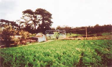
Photograph, Artichokes growing at Bell Street, Eltham, c.1990s
... About this time the area on the west side of Falkiner Street was purchased by a private developer and developed as housing. The area in Bell Street opposite the Eltham High School was purchased by the State Government is recent years and is called Fabbro Fields. ...About this time the area on the west side of Falkiner Street was purchased by a private developer and developed as housing. The area in Bell Street opposite the Eltham High School was purchased by the State Government is recent years and is called Fabbro Fields. ...Fabbro's farm and house, Bell Street, Eltham, c.1990s. A crop of artichokes were planted on the farm at this time. The site of the Fabbro farm (Diamond Creek side land) is now called Barrack Bushlands. It is doubtful that Fabbro's farm holding was ever called Barrak Park, This title is fairly recent after the Shire of Eltham purchased the land, including the last section in 1993/94. About this time the area on the west side of Falkiner Street was purchased by a private developer and developed as housing. The area in Bell Street opposite the Eltham High School was purchased by the State Government is recent years and is called Fabbro Fields. The Fabbro Family operated their farm in Bell Street, Eltham. 1 colour photograph printed with white borderfabbro's farm, bell street, eltham, artichokes, barak farm -
 Eltham District Historical Society Inc
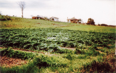
Photograph, Artichokes growing at Bell Street, Eltham, c.1990s
... About this time the area on the west side of Falkiner Street was purchased by a private developer and developed as housing. The area in Bell Street opposite the Eltham High School was purchased by the State Government is recent years and is called Fabbro Fields. ...About this time the area on the west side of Falkiner Street was purchased by a private developer and developed as housing. The area in Bell Street opposite the Eltham High School was purchased by the State Government is recent years and is called Fabbro Fields. ...Fabbro's farm and house, Bell Street, Eltham, c.1990s. A crop of artichokes were planted on the farm at this time. The site of the Fabbro farm (Diamond Creek side land) is now called Barrack Bushlands. It is doubtful that Fabbro's farm holding was ever called Barrak Park, This title is fairly recent after the Shire of Eltham purchased the land, including the last section in 1993/94. About this time the area on the west side of Falkiner Street was purchased by a private developer and developed as housing. The area in Bell Street opposite the Eltham High School was purchased by the State Government is recent years and is called Fabbro Fields. The Fabbro Family operated their farm in Bell Street, Eltham. 1 colour photograph printed with white borderfabbro's farm, bell street, eltham, artichokes, barak farm -
 Eltham District Historical Society Inc
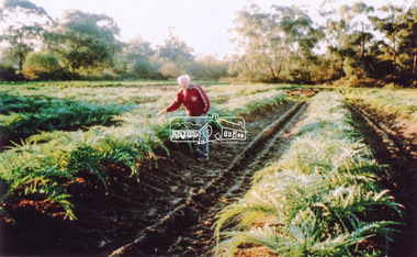
Photograph, Maurice Fabbro with artichokes growing at Bell Street, Eltham, c.1990s. Maurie is in his 70s
... About this time the area on the west side of Falkiner Street was purchased by a private developer and developed as housing. The area in Bell Street opposite the Eltham High School was purchased by the State Government is recent years and is called Fabbro Fields. ...About this time the area on the west side of Falkiner Street was purchased by a private developer and developed as housing. The area in Bell Street opposite the Eltham High School was purchased by the State Government is recent years and is called Fabbro Fields. ...Fabbro's farm and house, Bell Street, Eltham, c.1990s. A crop of artichokes were planted on the farm at this time. The site of the Fabbro farm (Diamond Creek side land) is now called Barrack Bushlands. It is doubtful that Fabbro's farm holding was ever called Barrak Park, This title is fairly recent after the Shire of Eltham purchased the land, including the last section in 1993/94. About this time the area on the west side of Falkiner Street was purchased by a private developer and developed as housing. The area in Bell Street opposite the Eltham High School was purchased by the State Government is recent years and is called Fabbro Fields. The Fabbro Family operated their farm in Bell Street, Eltham. 1 colour photograph printed with white borderfabbro's farm, bell street, eltham, artichokes, barak farm, maurice fabbro -
 Warrnambool and District Historical Society Inc.
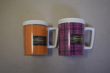
Mugs, Newlyne Mfg. Co Pty Ltd, Warrnambool Fabric Blankets, Mid 20th century
... The buildings were sold to a private developer and the first residents moved into the new housing estate in 2009. ...The buildings were sold to a private developer and the first residents moved into the new housing estate in 2009. ...These mugs are souvenirs of the Warrnambool Woollen Mill. They were either sold as souvenirs or given to clients of the mill. The Warrnambool Woollen Mill in South Warrnambool was opened in 1910 with the first manager being John Bennett, an Englishman who recruited skilled weavers and bought mill equipment from his home country. At the height of production the mill was employing up to 700 people. In 1958 the mill became the first in Australia to manufacture electric blankets. In 1968 the mill was sold to the Dunlop company and in the ensuing years various companies owned the plant. In the year 2000 the mill was closed and the equipment was sold. The buildings were sold to a private developer and the first residents moved into the new housing estate in 2009. These mugs are of interest as mementoes of the Warrnambool Woollen Mill, a key industry in the development of Warrnambool and one that operated for 90 years. .1 This is an insulated plastic mug with a mottled orange-coloured body and a white rim on the top opening and a white handle. On the side of the mug is a printed name with gold lettering on a brown background. The maker’s name is etched into the base of the mug. .2 This is an insulated plastic mug with a purple and black mottled body and a white rim on the top opening and a white handle. On the side of the mug is a printed name on a brown background with gold lettering. The maker’s name is etched into the base of the mug. .1 & .2 Warrnambool Fabrics Blankets Steditemp Insulated Ware Made in Australia by Newlyne MFG Co Pty Ltd Division of J. Glaser & Co Melbourne warrnambool woollen mill -
 Vision Australia
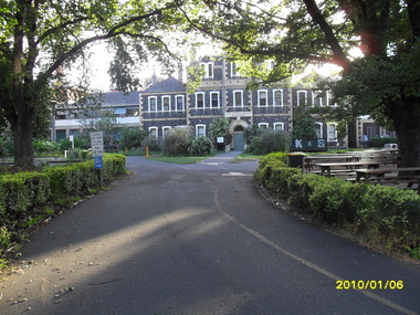
Photograph - Image, St Kilda Road building in 2010, 6/1/2010
... The remainder of the site was then sold on to another developer. Unable to quickly proceed with their plans on developing the site for residential buildings, the site fell into some disrepair in the interim which was when these images were taken. ...The remainder of the site was then sold on to another developer. Unable to quickly proceed with their plans on developing the site for residential buildings, the site fell into some disrepair in the interim which was when these images were taken. ...In 2007, Vision Australia sold it's iconic 557-563 St Kilda Road site. The historic bluestone building was in need of renovation and repair, had limited space for staff and clients and with more demand for services in suburban and regional areas, did not meet the needs of the national organisation. The purchaser was mainly interested in the Ormond Hall section, which they sub-divided off and sold to the tenant of the Belgian Beer Cafe. The remainder of the site was then sold on to another developer. Unable to quickly proceed with their plans on developing the site for residential buildings, the site fell into some disrepair in the interim which was when these images were taken. Later the site was sold again and residential buildings now occupy part of the block. 20 images taken of and from St Kilda Road buildingroyal victorian institute for the blind, buildings, myer house, ferguson and urie -
 Eltham District Historical Society Inc
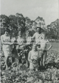
Photograph, Antonio and Angelina Casonato and family
... About this time the area on the west side of Falkiner Street was purchased by a private developer and developed as housing. The area in Bell Street opposite the Eltham High School was purchased by the State Government is recent years and is called Fabbro Fields. ...About this time the area on the west side of Falkiner Street was purchased by a private developer and developed as housing. The area in Bell Street opposite the Eltham High School was purchased by the State Government is recent years and is called Fabbro Fields. ...Antonio and Angelina Casonato with their four children and a baby cousin taken with lettuces growing on the river flat at Bell Street, Fabbro Farm (Fabbro Fields) in front of Eltham High School in the late 1960s. The site of the Fabbro farm (Diamond Creek side land) is now made up of Fabbro Fileds and Barrack Bushlands. This title is fairly recent after the Shire of Eltham purchased the land, including the last section in 1993/94. About this time the area on the west side of Falkiner Street was purchased by a private developer and developed as housing. The area in Bell Street opposite the Eltham High School was purchased by the State Government is recent years and is called Fabbro Fields. The Fabbro Family operated their farm in Bell Street, Eltham. 1 black and white photograph reproduction print (low quality)fabbro's farm, bell street, eltham, farming, vegetables, angelina casonato, antonio casonato, fabbro family, fabbro farm, fabbro fields -
 Eltham District Historical Society Inc
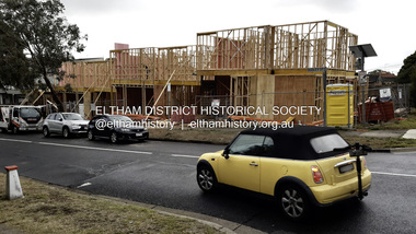
Photograph - Digital Photograph, Joan Castledine, 95 Bible Street, Eltham, 28 May 2025
... ...developer...The application was refused by Nillumbik Shire Council on 4 April 2022 and the developer subsequently lodged an Appeal at VCAT on 11 May 2022. ...The application was refused by Nillumbik Shire Council on 4 April 2022 and the developer subsequently lodged an Appeal at VCAT on 11 May 2022. ...95 Bible Street, Eltham was a 1950s weatherboard cottage situated on the northwest corner of Dudley Street and Bible Street on a land size of approximately 695 square metres. It was listed for sale by Morrison Kleeman on 22 February 2021 and sold for $1,275,000 on 13 March 2021. Planning application 557/2021/03P was submitted 23 June 2021 for demolition of original free standing cottage and buildings and works to construct four (4) two-story townhouse dwellings and removal of vegetation. The application was refused by Nillumbik Shire Council on 4 April 2022 and the developer subsequently lodged an Appeal at VCAT on 11 May 2022. The application was approved by VCAT on 2 February 2023. Construction commenced in 2025 with anticipated completion late 2025.95 bible street, bible street, building construction, developer, dudley street, etham, joan castledine collection, properties -
 Eltham District Historical Society Inc
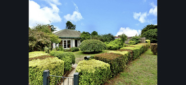
Photograph - Digital Photograph, Morrison Kleeman, 95 Bible Street, Eltham, February 2021
... ...developer...The application was refused by Nillumbik Shire Council on 4 April 2022 and the developer subsequently lodged an Appeal at VCAT on 11 May 2022. ...The application was refused by Nillumbik Shire Council on 4 April 2022 and the developer subsequently lodged an Appeal at VCAT on 11 May 2022. ...95 Bible Street, Eltham was a 1950s weatherboard cottage situated on the northwest corner of Dudley Street and Bible Street on a land size of approximately 695 square metres. It was listed for sale by Morrison Kleeman on 22 February 2021 and sold for $1,275,000 on 13 March 2021. Planning application 557/2021/03P was submitted 23 June 2021 for demolition of original free standing cottage and buildings and works to construct four (4) two-story townhouse dwellings and removal of vegetation. The application was refused by Nillumbik Shire Council on 4 April 2022 and the developer subsequently lodged an Appeal at VCAT on 11 May 2022. The application was approved by VCAT on 2 February 2023. Construction commenced in 2025 with anticipated completion late 2025.95 bible street, bible street, developer, dudley street, etham, properties, morrison kleeman estate agents -
 Eltham District Historical Society Inc
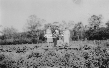
Photograph, At Bell Street, Eltham; from left: Helen Skipper, Matcham Skipper, Sonia Skipper and possibly Myra Skipper
... About this time the area on the west side of Falkiner Street was purchased by a private developer and developed as housing. The area in Bell Street opposite the Eltham High School was purchased by the State Government is recent years and is called Fabbro Fields. ...About this time the area on the west side of Falkiner Street was purchased by a private developer and developed as housing. The area in Bell Street opposite the Eltham High School was purchased by the State Government is recent years and is called Fabbro Fields. ...At Bell Street, Fabbro Farm, Eltham; From left: Helen Skipper, Matcham Skipper, Sonia Skipper and possibly Myra Skipper, standing in the middle of a vegetable crop. The site of the Fabbro farm (Diamond Creek side land) is now called Barrack Bushlands. It is doubtful that Fabbro's farm holding was ever called Barrak Park, This title is fairly recent after the Shire of Eltham purchased the land, including the last section in 1993/94. About this time the area on the west side of Falkiner Street was purchased by a private developer and developed as housing. The area in Bell Street opposite the Eltham High School was purchased by the State Government is recent years and is called Fabbro Fields. The Fabbro Family operated their farm in Bell Street, Eltham. 1 black and white photographfabbro's farm, bell street, eltham, farming, helen skipper, vegetables, matchcam skipper, myra skipper, sonia skipper -
 Eltham District Historical Society Inc
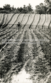
Photograph, George W. Bell, Fabbro's Market Garden, South Eltham, 1960s
... About this time the area on the west side of Falkiner Street was purchased by a private developer and developed as housing. The area in Bell Street opposite the Eltham High School was purchased by the State Government is recent years and is called Fabbro Fields. ...About this time the area on the west side of Falkiner Street was purchased by a private developer and developed as housing. The area in Bell Street opposite the Eltham High School was purchased by the State Government is recent years and is called Fabbro Fields. ...Fabbro's market garden. Much of the creek side land is now called Barrak Bushlands, a title that is fairly recent after the Shire of Eltham purchased the land, including the last section in 1993/94. About this time the area on the west side of Falkiner Street was purchased by a private developer and developed as housing. The area in Bell Street opposite the Eltham High School was purchased by the State Government is recent years and is called Fabbro Fields. When times became tough and vegetables were no longer bringing in the money, Maurie started selling the fertile top soil. He scraped much of the top soil into mounds and these mounds are now visible, covered in grass as one walks along the Diamond Creek Trail through there.Two black and white photographs 1. ploughed land Fabbro's market garden Eltham South c.1960s 2. field of crops 1970farming, market gardens, eltham, eltham south, fabbro, falkiner street, george w bell collection -
 Ringwood and District Historical Society
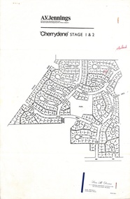
Flyer, Land Sale Advertisement - Cherrydene Estate, Stage 1 & 2, Ringwood, Vic. - 1969
... Subdivison map of Cherrydene Estate and double-sided A4 size House & Land price list dated 27/10/1969. Developer - A.V. Jennings Industries (Aust) Ltd., Cnr. ...Subdivison map of Cherrydene Estate and double-sided A4 size House & Land price list dated 27/10/1969. Developer - A.V. Jennings Industries (Aust) Ltd., Cnr. ...Subdivison map of Cherrydene Estate and double-sided A4 size House & Land price list dated 27/10/1969. Developer - A.V. Jennings Industries (Aust) Ltd., Cnr. Springvale & Wellington Rds., Mulgrave, Vic. Phone 560 8411. Sales Dept. Rep., Leon B. Devine, Phone 560 8411 A/H.435 5311. Subdivision includes Wonga Road, Holyrood Crescent, Clipper Court, Ripley Court, Harwick Close, Bader Court, Towerhill Drive, Nigel Court, Berkley Road, Avis Court, Carmen Close, Frederic Drive, Kenwood Crescent, Adele Court, Marilyn Street, Abbey Court, Baron Court, Kismet Close, Oban Road, Ringwood.Furnished and landscaped display homes are open for your inspection, (see map on reverse side) from 11 a.m. to 5 p.m. Sundays and Holidays, and 2 p.m. to 5 p.m. weekdays and Saturdays. Display homes list for 'Cherrydene' Ringwood - Arundel, Ashmoor, Avalon, Cleveland, Chiltern, Dorset. -
 Bendigo Historical Society Inc.
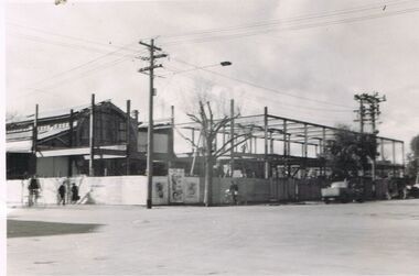
Photograph - S.E.C. VICTORIA, 1939
... Rear of photo has stamped name of the developer of the photo printed by Oliver's Bendigo. ...Rear of photo has stamped name of the developer of the photo printed by Oliver's Bendigo. ...Photograph - black and white. The new SEC building still under construction. The 'old market building' can be seen to the left of the photo. Man on bicycle in dark clothing, man in black clothing walking to the right, lady in dark clothing walking to the left, light post with three cross bars and street light, advertising material displayed on corner section of fence, man in black standing over bhis bicycle to right of tree, dark colour utility vehicle parked in williamson street, twin power poles connected with 5 or six cross bars, vehicle angle parked in front of utility. Rear of photo has stamped name of the developer of the photo printed by Oliver's Bendigo. Number 79 witten in pencil.Printed by Olivers, Bendigo.organization, public utility, electricity company, s.e.c. victoria. 1939. bendigo. -
 Kew Historical Society Inc
Plan - Subdivision Plan, Old Kew Golf Links Estate - Third Section, 1920-1929
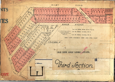
... When the old Kew Golf Links was subdivided in the mid 1920s, the developers were able to break the sale into sections. ...Barnes. subdivision plans - kew old kew golf links estate - third section When the old Kew Golf Links was subdivided in the mid 1920s, the developers were able to break the sale into sections. ...Pru Sanderson, in her groundbreaking ‘City of Kew Urban Conservation Study : Volume 2 - Development History’ (1988), summarised the periods of urban development and subdivisions of land in Kew. The periods that she identified included 1845-1880, 1880-1893, 1893-1921, 1921-1933, 1933-1943, and Post-War Development. These periods were selected as they represented periods of rapid growth or decline in urban development. An obvious starting point for Sanderson’s groupings involved population growth and the associated economic cycles. These cycles also highlighted urban expansion onto land that was predominantly rural, although in other cases it represented the decline and breakup of large estates. A number of the plans in the Kew Historical Society’s collection can also be found in other collections, such as those of the State Library of Victoria and the Boroondara Library Service. A number are however unique to the collection.The Kew Historical Society collection includes almost 100 subdivision plans pertaining to suburbs of the City of Melbourne. Most of these are of Kew, Kew East or Studley Park, although a smaller number are plans of Camberwell, Deepdene, Balwyn and Hawthorn. It is believed that the majority of the plans were gifted to the Society by persons connected with the real estate firm - J. R. Mathers and McMillan, 136 Cotham Road, Kew. The Plans in the collection are rarely in pristine form, being working plans on which the agent would write notes and record lots sold and the prices of these. The subdivision plans are historically significant examples of the growth of urban Melbourne from the beginning of the 20th Century up until the 1980s. A number of the plans are double-sided and often include a photograph on the reverse. A number of the latter are by noted photographers such as J.E. Barnes.When the old Kew Golf Links was subdivided in the mid 1920s, the developers were able to break the sale into sections. The third section included eighty lots. The lots faced Kilby Road, Kodak Avenue, Belford Road, Baker Avenue, Mathers Avenue, and White Avenue. [Kodak Avenue was renamed Page Avenue at a later date].The ‘Kew Conservation Study (1988) notes that ‘On the subdivision plan, Kodak’s involvement is commemorated by the naming of the streets after Company directors, and their decision to not proceed with the construction of the factory is explained as a response to the increase in the value of the land. This explanation may have been Estate Agent’s hyperbole, as the Kodak Company records suggest that the land, with its wide creek gully, was unsuitable and too small for its purposes.subdivision plans - kew, old kew golf links estate - third section -
 Federation University Historical Collection
Book - History, Cesar A. Becerra, Orange Blossom 2.0, 2021
... Originally from Australia, MAry Brickell was a major landowner, developer and very savvy businesswoman, who seems to have been largely overlooked in the histoy of the founding of Miami. ...Originally from Australia, MAry Brickell was a major landowner, developer and very savvy businesswoman, who seems to have been largely overlooked in the histoy of the founding of Miami. ...A historical book about Miami, centred around one of the primary city founders Mary Brickell. Author and historian Cesar BererraOrange title - Black orange image top left - Black & White Book, 235 pages, about Julia Tuttle the mother of Miami (Head image of Mary Brickell - Inside front and back cover - Orange images (front/back cover)non-fictionA historical book about Miami, centred around one of the primary city founders Mary Brickell. Author and historian Cesar Bererramary brickell, julia tuttle, miami, florida, city of brickell, william brickell -
 City of Moorabbin Historical Society (Operating the Box Cottage Museum)
Document,leaflet 'Brief History of the City of Moorabbin 1850 - 1934', 2015
... Topics ; Aboriginal Bunurrung people, Henry Dendy's Special Survey 1841 in County of Bourke ; J.B Were, land agent, Pastoralists/ Squatters John O'Shannassy, Richard & John King, Moysey Family, Alexander MacDonald; Parish of Moorabbin Land Developers 1850 J.Holloway, A. Balcombe, D.Wickham, S. ...Topics ; Aboriginal Bunurrung people, Henry Dendy's Special Survey 1841 in County of Bourke ; J.B Were, land agent, Pastoralists/ Squatters John O'Shannassy, Richard & John King, Moysey Family, Alexander MacDonald; Parish of Moorabbin Land Developers 1850 J.Holloway, A. Balcombe, D.Wickham, S. ...2015 CMHS members D. Maynard. Fran & Holger Bader compiled this Leaflet to provide a condensed information Leaflet about the origin and development of the area known as 'The City of Moorabbin' from 1850 -1994. Topics ; Aboriginal Bunurrung people, Henry Dendy's Special Survey 1841 in County of Bourke ; J.B Were, land agent, Pastoralists/ Squatters John O'Shannassy, Richard & John King, Moysey Family, Alexander MacDonald; Parish of Moorabbin Land Developers 1850 J.Holloway, A. Balcombe, D.Wickham, S. Charman, Keys Family; Road District of Moorabbin 1862 - 1870; Shire of Moorabbin 1871 - 1934; City of Moorabbin 1934 - 94; Amalgamation of Councils 1994 divided the City of Moorabbin between the Cities of Glen Eira, Bayside, Kingston and Monash; Origin of suburb names,This Leaflet was compiled in 2015 to provide a condensed history of the area known as 'The City of Moorabbin' for visitors , schools and local community1 x A4 printed both sides, black and white, folded x 3page 1 'BRIEF HISTORY OF THE CITY OF MOORABBIN' ; CITY OF MOORABBIN /1934-1994 page 2 'CITY OF MOORABBIN / 1934 - 94 city of moorabbin, county of bourke, moorabbin roads board, parish of moorabbin, shire of moorabbin, henry dendy's special survey 1841, were j.b.; bent thomas, o'shannassy john, king richard, charman s, highett william, ormond francis, maynard dennis, -
 Eltham District Historical Society Inc
Photograph, H.J. Trowbridge, First kitchen at the first Post Office, Kinglake, c.1905, 1905
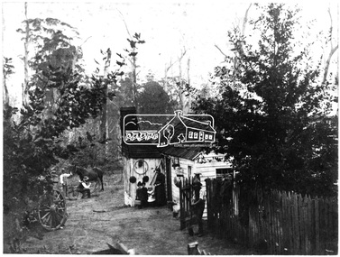
... Trowbridge," a photographer operating from at least 1895 and a photo stock dealer, developer and printer operating from Camera House in Collins St, Melbourne importing the finest English photographic equipment, paper, etc from 1905 through 1910 when he retired (Photo-focus. (1910, September 1). ...Trowbridge," a photographer operating from at least 1895 and a photo stock dealer, developer and printer operating from Camera House in Collins St, Melbourne importing the finest English photographic equipment, paper, etc from 1905 through 1910 when he retired (Photo-focus. (1910, September 1). ...Reproduced 'Pioneers & Painters' p43 Source: Mrs. McMinn, Kinglake The photo is embossed in the lower left hand "H.J. Trowbridge," a photographer operating from at least 1895 and a photo stock dealer, developer and printer operating from Camera House in Collins St, Melbourne importing the finest English photographic equipment, paper, etc from 1905 through 1910 when he retired (Photo-focus. (1910, September 1). Punch (Melbourne, Vic. : 1900 - 1918; 1925), p. 3. Retrieved from http://nla.gov.au/nla.news-article175606285). He produced a 200 page catalogue in 1906 (H. J. TROWBRIDGE'S CATALOGUE. (1906, November 22). Punch (Melbourne, Vic. : 1900 - 1918; 1925), p. 3. Retrieved from http://nla.gov.au/nla.news-article175379934)This photo forms part of a collection of photographs gathered by the Shire of Eltham for their centenary project book,"Pioneers and Painters: 100 years of the Shire of Eltham" by Alan Marshall (1971). The collection of over 500 images is held in partnership between Eltham District Historical Society and Yarra Plenty Regional Library (Eltham Library) and is now formally known as 'The Shire of Eltham Pioneers Photograph Collection.' It is significant in being the first community sourced collection representing the places and people of the Shire's first one hundred years.Digital image of 4 x 5 inch B&W Negative Also 19 x 25 cm printPhotographers name H.J. Trowbridge Lwr LHsepp, shire of eltham pioneers photograph collection, kinglake, post office -
 Eltham District Historical Society Inc
Photograph, At Bell Street; from left: Maurie Fabbro, Myra Skipper, Unknown, Arthur Munday, Ian Robertson. Helen Comprione in front
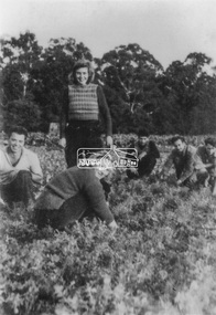
... About this time the area on the west side of Falkiner Street was purchased by a private developer and developed as housing. The area in Bell Street opposite the Eltham High School was purchased by the State Government is recent years and is called Fabbro Fields. ...About this time the area on the west side of Falkiner Street was purchased by a private developer and developed as housing. The area in Bell Street opposite the Eltham High School was purchased by the State Government is recent years and is called Fabbro Fields. ...At Bell Street, Fabbro Farm, Eltham; from left: Maurie Fabbro, Myra Skipper, Unknown, Arthur Munday, Ian Robertson. Helen Comprione in front - probably helping to pick a crop. The site of the Fabbro farm (Diamond Creek side land) is now called Barrack Bushlands. It is doubtful that Fabbro's farm holding was ever called Barrak Park, This title is fairly recent after the Shire of Eltham purchased the land, including the last section in 1993/94. About this time the area on the west side of Falkiner Street was purchased by a private developer and developed as housing. The area in Bell Street opposite the Eltham High School was purchased by the State Government is recent years and is called Fabbro Fields. The Fabbro Family operated their farm in Bell Street, Eltham. 1 black and white photographfabbro's farm, guido fabbro, bell street, arhur munday, eltham, helen comprione, ian robertson, maurice fabbro, myra skipper, picking, farming -
 Eltham District Historical Society Inc
Photograph, Baby eagle on nest, 'The Chase', Warrandyte, c.1990
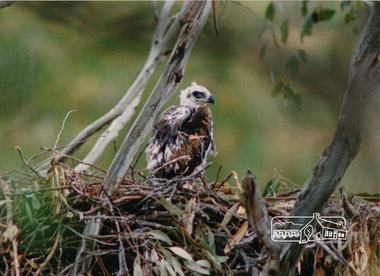
... In December 1990, Eltham Shire Council voted to acquire 12 hectares of The Chase for a wildlife reserve; the developers received a compensation package which included $125,000 and the right to sell two extra allotments."...In December 1990, Eltham Shire Council voted to acquire 12 hectares of The Chase for a wildlife reserve; the developers received a compensation package which included $125,000 and the right to sell two extra allotments." wildlife eagle warrandyte the chase. ...Defending The Chase by Marcel Cameron; November 16, 1994, Issue 167, News Retrieved from https://www.greenleft.org.au/1994/167/news/defending-chase "In August 1990, a grassroots campaign to halt clearing of bush at The Chase began after access roads encroached on the nesting habitat of Melbourne's last family of wedge-tailed eagles. Three on-site demonstrations were each attended by up to 200 people and attracted widespread media coverage. Young people played an active role in the campaign, including people from Environmental Youth Alliance, Children for Conservation and local school students. In December 1990, Eltham Shire Council voted to acquire 12 hectares of The Chase for a wildlife reserve; the developers received a compensation package which included $125,000 and the right to sell two extra allotments."Colour photograph of a baby wedge-tail eagle on the nest at 'The Chase', Warrandyte.wildlife, eagle, warrandyte, the chase. -
Bendigo Historical Society Inc.
Newspaper - Fortuna Articles - "Residents share concerns over Fortuna debacle", Feb 14 2014
... One additional objection was later withdrawn. The developer, Paul Banks, expects a quick resolution and believes that state government and council support means the rezoning is likely to be approved regardless of objections....One additional objection was later withdrawn. The developer, Paul Banks, expects a quick resolution and believes that state government and council support means the rezoning is likely to be approved regardless of objections. bendigo fortuna george lansell paul banks owner fortuna Fortuna Articles - "Residents share concerns over Fortuna debacle" Feb 14 2014 The Bendigo Advertiser by Emma-Jayne Schenk This item contains the following: 11217.52a Part of Page 7 - Fortuna Articles - "Residents share concerns over Fortuna debacle" Newspaper Fortuna Articles - "Residents share concerns over Fortuna debacle" ...Residents fear that if the zoning amendment is approved, they will lose their legal right to object or appeal future developments, particularly through VCAT (Victorian Civil and Administrative Tribunal).The contract associated with the rezoning allows residents to comment to the council but removes their ability to formally object or appeal. Residents are not opposed to development at Fortuna itself but are specifically worried about another parcel of land (View Street) and want to retain their right to have input on its future development. The proposal, submitted by owner Paul Banks, has been referred to an independent panel after receiving an objection with six signatories. One additional objection was later withdrawn. The developer, Paul Banks, expects a quick resolution and believes that state government and council support means the rezoning is likely to be approved regardless of objections.Fortuna Articles - "Residents share concerns over Fortuna debacle" Feb 14 2014 The Bendigo Advertiser by Emma-Jayne Schenk This item contains the following: 11217.52a Part of Page 7 - Fortuna Articles - "Residents share concerns over Fortuna debacle"non-fictionbendigo, fortuna, george lansell, paul banks owner fortuna -
 St Kilda Historical Society
Artwork, other - Poster, Fred Negro, Keep the Espy Live Benefit, 2003
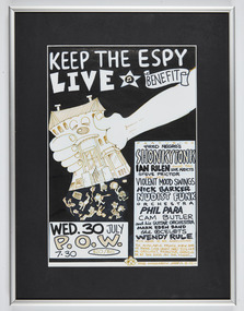
... The Esplanade Alliance started the Keep the Espy Live campaign to raise funds to oppose an appeal by the developers against the Council's decision to refuse its planning application. ...The Esplanade Alliance started the Keep the Espy Live campaign to raise funds to oppose an appeal by the developers against the Council's decision to refuse its planning application. ...Poster advertising a benefit concert, held on 30 July at 7:30pm at the Prince of Wales hotel on Fitzroy Street St Kilda, to support the campaign to protect The Esplanade Hotel as a premier venue for live music. Performers included Fred Negro's Shonkytonk, Ian Rilen and the Love Addicts, Steve Prictor and his Violent Mood Swings, Nick Barker, Nudist Funk Orchestra, Phil Para, Cam Butler and his Guitar Orchestra, Mark Eden Band, the Ocelots, Wendy Rule 'plus more to be announced'. The event was held toward the end of an extensive and protracted six-year community battle over the proposed redevelopment of the hotel. The Esplanade Alliance started the Keep the Espy Live campaign to raise funds to oppose an appeal by the developers against the Council's decision to refuse its planning application. Original artwork for poster in metal frameespy, esplanade hotel, political activity -
 Sunshine and District Historical Society Incorporated
Archive - Metropolitan Fire Brigade Building, 1927
... Photos taken from Sunshine Cavalcade of early Sunshine Metropolitan Fire Brigade Including personnel building and equipment The brigade was made up of volunteers two slept on the premises each night on alarm all staff hurried to blaze L2R Chris Curtain Captain Jock Guy Stan Barkla Bill Burnside Alex Wilson Bill Troon Sunshine Metropolitan Fire Brigade corner of Hampshire Road and Hertford Street vacated approximately 1990 This property was bought by a private developer On 21 February 21 1995 Tobin Brothers developed the building for funeral parlour business Negatives Only taken from photographs in Sunshine Cavalcade Negatives filed in Film Folio No 18 Loose Negatives...Fire Station Photos taken from Sunshine Cavalcade of early Sunshine Metropolitan Fire Brigade Including personnel building and equipment The brigade was made up of volunteers two slept on the premises each night on alarm all staff hurried to blaze L2R Chris Curtain Captain Jock Guy Stan Barkla Bill Burnside Alex Wilson Bill Troon Sunshine Metropolitan Fire Brigade corner of Hampshire Road and Hertford Street vacated approximately 1990 This property was bought by a private developer On 21 February 21 1995 Tobin Brothers developed the building for funeral parlour business Negatives Only taken from photographs in Sunshine Cavalcade Negatives filed in Film Folio No 18 Loose Negatives Metropolitan Fire Brigade Building Archive Metropolitan Fire Brigade Building ...Photos taken from Sunshine Cavalcade of early Sunshine Metropolitan Fire Brigade Including personnel building and equipment The brigade was made up of volunteers two slept on the premises each night on alarm all staff hurried to blaze L2R Chris Curtain Captain Jock Guy Stan Barkla Bill Burnside Alex Wilson Bill Troon Sunshine Metropolitan Fire Brigade corner of Hampshire Road and Hertford Street vacated approximately 1990 This property was bought by a private developer On 21 February 21 1995 Tobin Brothers developed the building for funeral parlour business Negatives Only taken from photographs in Sunshine Cavalcade Negatives filed in Film Folio No 18 Loose Negativesfire station -
 Bendigo Historical Society Inc.
Memorabilia - Bendigo Advertiser Collection: Frank Bullen, New Building 2004
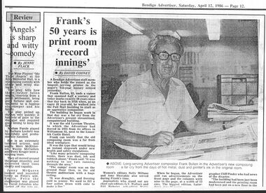
... Pictured on the vacant sight are Builder Terry Hurford, Developers B.J. Edwards and Brendan Edwards and Advertiser General Manager Peter Dehnert looking at the plans....Pictured on the vacant sight are Builder Terry Hurford, Developers B.J. Edwards and Brendan Edwards and Advertiser General Manager Peter Dehnert looking at the plans. ...The Bendigo Advertiser was first published in 1853. The Bendigo Independent was founded in 1866. In November 1918 the papers amalgamated and continued under The Bendigo Advertiser banner. The Bendigo Advertiser currently delivers news as a printed newspaper, digital paper and on its website and social media. The paper changed from broadsheet to Tabloid in 1998.A4 photocopy of a Bendigo Advertiser article and photograph dated Aprill 12, 1986 by David Cooney about Frank Bullen, 65 who was retiring after 50 years of service with the Bendigo Advertiser. He held the record as the longest serving printer in the paper's 133-year history. In the photograph Frank is sitting at a desk with a newspaper in the new composing room. And a cutting from the Advertiser, Wednesday, November 3, 2004, with an article and photograph about the construction of the Advertiser's new premises at 47 Queen Street Bendigo. The building was designed local architect Micheal Huges and was a joint project between Morey and Hurford Pty Ltd and Robren Development. Pictured on the vacant sight are Builder Terry Hurford, Developers B.J. Edwards and Brendan Edwards and Advertiser General Manager Peter Dehnert looking at the plans.the bendigo advertiser, frank bullen -
 Eltham District Historical Society Inc
Photograph, Maurice Fabbro and his mother Regina (wife of Guido) taken at home in Falkiner Street, Eltham
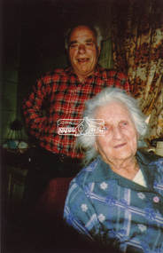
... About this time the area on the west side of Falkiner Street was purchased by a private developer and developed as housing. The area in Bell Street opposite the Eltham High School was purchased by the State Government is recent years and is called Fabbro Fields. ...About this time the area on the west side of Falkiner Street was purchased by a private developer and developed as housing. The area in Bell Street opposite the Eltham High School was purchased by the State Government is recent years and is called Fabbro Fields. ...Maurice Fabbro and his mother Regina (wife of Guido) taken at home in Falkiner Street, Eltham. Regina passed away 21/03/1986 age 92 and is buried at Eltham Cemetery. (source: http://www.elthamcemetery.com/index.php/deceased-search) The site of the Fabbro farm (Diamond Creek side land) is now called Barrack Bushlands. It is doubtful that Fabbro's farm holding was ever called Barrak Park, This title is fairly recent after the Shire of Eltham purchased the land, including the last section in 1993/94. About this time the area on the west side of Falkiner Street was purchased by a private developer and developed as housing. The area in Bell Street opposite the Eltham High School was purchased by the State Government is recent years and is called Fabbro Fields. The Fabbro Family operated their farm in Bell Street, Eltham. Eltham, Falkiner Street, Maurice Fabbro, Regina Fabbro1 colour photographfabbro's farm, bell street, eltham, maurice fabbro, regina fabbro -
 Sunshine and District Historical Society Incorporated
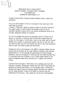
Archive - H.V. McKay Replica Smithy Opening 2001 Documents
... Black & white of the Smithy on the Devonshire Rd Offices site|4/ Plans of the Smithy construction|5/ Trade Mark "Sunshine" Certificate of Registration of a trade mark with the Patent, Trade Marks and Designs Offices Canberra 1907|6/ Request for transfer of original building from Museum Victoria to Sunshine was refused on 23/12/1998 & McKay's Massey Ferguson Site hearing on the demolishment of the substation site with developer to contribute $100,000 for interpretive centre on the site|7/ References for information on H.V. ...Black & white of the Smithy on the Devonshire Rd Offices site|4/ Plans of the Smithy construction|5/ Trade Mark "Sunshine" Certificate of Registration of a trade mark with the Patent, Trade Marks and Designs Offices Canberra 1907|6/ Request for transfer of original building from Museum Victoria to Sunshine was refused on 23/12/1998 & McKay's Massey Ferguson Site hearing on the demolishment of the substation site with developer to contribute $100,000 for interpretive centre on the site|7/ References for information on H.V. ...A collection of documents from John Kemndall A.M. (Former Director Museum Victoria)1/ Bring back the H.V. Smithy Barclay Reserve Talmage Street Sunshine 10 October 2001 Address by John Kendall A.M.|2/ From Log Smithy to Millionaire. Notes on Hugh Victor McKay and the stripper-harvester|3/ The Sunshine Harvester Works in 1884. Black & white of the Smithy on the Devonshire Rd Offices site|4/ Plans of the Smithy construction|5/ Trade Mark "Sunshine" Certificate of Registration of a trade mark with the Patent, Trade Marks and Designs Offices Canberra 1907|6/ Request for transfer of original building from Museum Victoria to Sunshine was refused on 23/12/1998 & McKay's Massey Ferguson Site hearing on the demolishment of the substation site with developer to contribute $100,000 for interpretive centre on the site|7/ References for information on H.V. McKaysmithy, blacksmith, barclay reserve, albion -
 Warrnambool and District Historical Society Inc.
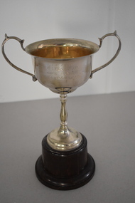
Trophy, ISCA Bates Cup Deck Quoits, 1930s
... This trophy was the Bates Cup and it was probably donated by Harold Bates, a property developer who was a Warrnambool City Councillor from 1941 to 1945. ...This trophy was the Bates Cup and it was probably donated by Harold Bates, a property developer who was a Warrnambool City Councillor from 1941 to 1945. ...This trophy is one of several from the 1930s that were awarded as part of the competitions held in Warrnambool by the Inter-Church Indoor Sports Association. One of the sponsors of this competition was Fletcher Jones, the well-known clothing manufacturer who had his head office and main factory in Warrnambool. This trophy was the Bates Cup and it was probably donated by Harold Bates, a property developer who was a Warrnambool City Councillor from 1941 to 1945. This trophy was for the deck quoits competition. The game of quoits consists of competitors throwing four or five rings or hoops on to a raised spike some metres away. The hoops are generally made of plaited rope and the game is said to have been started or popularized by sailors on board ship. In deck quoits the raised spike is usually replaced by concentric circles drawn on the playing surface. This game became very popular on ocean liner cruise ships from the 1920s on. The winner of this trophy is not known.This cup is retained as a fine example of the trophies awarded for indoor sport in the 1930s in Warrnambool by the now-defunct inter church sporting associationThis is an electro plated nickel silver cup with two side handles and a thin stem on a silver base. The cup is mounted on a brown circular Bakelite stand. ‘I.C.I.S.A. Bates Cup Deck Quoits Championship’inter church sporting competitions warrnambool, warrnambool history -
 Federation University Art Collection
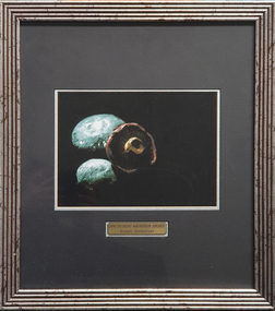
Photograph, Steinfort, Jessie, 'Mushrooms' by Jessie Steinfort, 1998
... From 2008 to 2011 Steinfort was lead designer and front-end web developer at clickDM (now HARDWIRE). Where he worked with such clients as HOSTPLUS, GSK, UniSuper and Swann Insurance. ...From 2008 to 2011 Steinfort was lead designer and front-end web developer at clickDM (now HARDWIRE). Where he worked with such clients as HOSTPLUS, GSK, UniSuper and Swann Insurance. ...Jessie STEINFORT Steinfort was Studied Graphic Design at the University of Ballarat (later Federation University) After 12 years of working in design studios and advertising agencies, Steinfort is now a Senior Designer at Ogilvy Melbourne. And previously, he has been responsible for work on BMW & Mini, Carlton Football club, Melbourne Convention and Exhibition Centre, Melbourne Food & Wine Festival, AAMI, Yarra Valley Water, and Arts Centre Melbourne. From 2008 to 2011 Steinfort was lead designer and front-end web developer at clickDM (now HARDWIRE). Where he worked with such clients as HOSTPLUS, GSK, UniSuper and Swann Insurance. From 2000 to 2008 Steinfort was a designer at Mediation Communications working on print and interactive projects for; City of Melbourne, City of Greater Geelong, City of Port Phillip, Mentor Education, and ACMA. This item is part of the Federation University Art Collection. The Art Collection features over 2000 works and was listed as a 'Ballarat Treasure' in 2007. Framed photograph of three mushrooms in a black background. This work was won the 1998 Student Acquisition Award. If you can provide information on this artist or artwork please use the email link below. photography, foto, mushrooms, food, close up, macro, colour, photo, jessie steinfort, alumni, available -
 City of Moorabbin Historical Society (Operating the Box Cottage Museum)
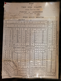
Document,photocopy plan 'Two Acre Village 'c1852, c1960
... In the 1852 Josiah Holloway, a developer, purchased 625 acres from the squatters Richard and John King and sectioned '2 acre allotments' south of Henry Dendy's Brighton Survey along the Arthur's Seat Road ( later Nepean Highway) for sale @ £10 It became known as The Two Acre Village as settlers took up the allotments and established market gardens, general stores, butchers, blacksmiths, post office and 2 hotels. ...In the 1852 Josiah Holloway, a developer, purchased 625 acres from the squatters Richard and John King and sectioned '2 acre allotments' south of Henry Dendy's Brighton Survey along the Arthur's Seat Road ( later Nepean Highway) for sale @ £10 It became known as The Two Acre Village as settlers took up the allotments and established market gardens, general stores, butchers, blacksmiths, post office and 2 hotels. ...In the 1852 Josiah Holloway, a developer, purchased 625 acres from the squatters Richard and John King and sectioned '2 acre allotments' south of Henry Dendy's Brighton Survey along the Arthur's Seat Road ( later Nepean Highway) for sale @ £10 It became known as The Two Acre Village as settlers took up the allotments and established market gardens, general stores, butchers, blacksmiths, post office and 2 hotels. Charles Whorral opened The Cheltenham Inn and it became so popular as a meeting place that the area was called Cheltenham. The early settlers, who were predominantly English and Scottish immigrants initially leased their allotments and, because the sandy soil was so fertile, they were soon able to purchase the land and increase their acreage. Cheltenham became a very important part of the large Moorabbin Shire1871 and City of Moorabbin 1934 In the 1994 Amalgamation of Councils, when the large City of Moorabbin was divided between the newly formed Glen Eira, Kingston and Bayside Councils, the Cheltenham area was assigned to the City of Kingston A photocopy of the Plan for the 2 Acre Village in Moorabbin Parish c1852. A3 laminatedmoorabbin, brighton, cheltenham, market gardeners, pioneers, early settlers, , king. john, holloway josiah, whorral charles, arthur’s seat road, nepean highway , cheltenham inn hotel, henry dendy special survey 1841 -
 Eltham District Historical Society Inc
Document - Property Binder, 981 Main Road, Eltham
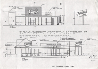
... In 1996 Wayne Phillips MLA announced that Caldeed P/L was the preferred developer of the land at Eltham Station for a proposed commercial development and commuter car parking (The Advertiser, April 16, 1996). ...In 1996 Wayne Phillips MLA announced that Caldeed P/L was the preferred developer of the land at Eltham Station for a proposed commercial development and commuter car parking (The Advertiser, April 16, 1996). ...The site was previously used as an unsealed car park for the Eltham Railway Station. In 1996 Wayne Phillips MLA announced that Caldeed P/L was the preferred developer of the land at Eltham Station for a proposed commercial development and commuter car parking (The Advertiser, April 16, 1996). Blockbuster Eltham was established on this site around 1996-1997. Following the company's 2010 bankruptcy and subsequent nationwide store liquidations, most Victorian Blockbuster locations were shuttered between March and May 2011 after ownership changes, with the Eltham storefront closing Friday, 13th April 2012. The last Australian store closed in 2019 in Morley, Western Australia. An unofficial Facebook page remains in existence in 2026 at https://www.facebook.com/pages/Blockbuster%20Eltham/123397434395463/ The shop was then converted to a Liquorland store. The site was sold 25 August 2015 with a ten year lease in place to Liquorland. A new lease was signed 4 March 2022 and the store converted to a Grill'd Hamburger restaurant, opening its doors September 8, 2022. eltham, shops, businesses, blockbuster, eltham shops, grill'd, liquorland, main road eltham -
 Sunshine and District Historical Society Incorporated
Photograph - Maribyrnong State School Under Construction Photographs
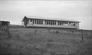
... The school side was the sold to land developers who developed it into a small housing estate....The school side was the sold to land developers who developed it into a small housing estate. ...Maribyrnong State School (also known as Maribyrnong Primary School) operated from the early 20th century until the late 20th century, serving the riverside industrial–residential community around Raleigh Road and the Maribyrnong River. The school was established in 1912. At first the school assembled in the Maribyrnong Methodist Church on the corner of Raleigh Street and Rosamond Rd. In 1916 the school was relocated to the corner of Raleigh Street and Wests Rd. In 1942 the school moved to the Warrs Rd site. During the post war and migration era’s (1950s–1970s), the school became increasingly multicultural due to the nearby Maribyrnong Migrant Hostel (opened 1949) with many European, Middle Eastern, and later Asian migrant students. Maribyrnong State School was one of the first inner west schools to run integration programs for newly arrived children, a pattern later continued by Maribyrnong High School. The school closed on the 31st December 1993. The school side was the sold to land developers who developed it into a small housing estate.This photograph captures the new school being built on the Warrs Road site in the early 1940's.maribyrnong state school, warrs road, maribyrnong -
 Sunshine and District Historical Society Incorporated
Photograph - St. Johns Church Miles Street Deer Park 1991 Photographs, Adam Ellwood, 8th February 1991
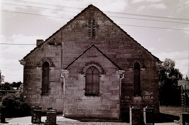
... Its construction coincided with Melbourne’s 1890s land‑boom, when developers were subdividing outer districts and the Church of England began establishing small mission churches to serve new settlements. ...Its construction coincided with Melbourne’s 1890s land‑boom, when developers were subdividing outer districts and the Church of England began establishing small mission churches to serve new settlements. ...St John’s Anglican Church on Miles Street, Deer Park was built in 1891. Its construction coincided with Melbourne’s 1890s land‑boom, when developers were subdividing outer districts and the Church of England began establishing small mission churches to serve new settlements. St John’s was a simple weatherboard, gabled church, built in a vernacular Gothic style typical of small rural Anglican churches. Key features included: timber cladding, steep gabled roof, small and enclosed porch facing Miles Street, minimal ornamentation and an adjacent concrete‑block parish hall (added mid‑20th century). The church’s simplicity reflected the modest means of early Deer Park families and the mission‑church model used by the Anglican Church in new suburbs. In 2016, the St John’s Anglican Church on Miles Street was completely destroyed by fire. Subsequently the church site was sold and developed into the Deer Park Early Learning and Kindergarten Centre in the early 2020's.The St John’s Church was the oldest church in Deer Park, the second‑oldest Anglican church in the district and the only church in Deer Park until the 1960s.St. John's Church Deer Parkst. johns church, miles street, deer park
