Showing 1135 items matching " east kew"
-
 Ballarat Heritage Services
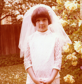
Photograph - Colour, First Communicate, 10/1978
... East Kew....Beresford St , East Kew, Victoria, Australia... at St Anne's East Kew. lisa gervasoni first holy communion ...Lisa Gervasoni made her First Holy Communion at St Anne's East Kew.Colour photograph of Lisa Gervasoni wearing her First Holy Communion outfil lisa gervasoni, first holy communion -
 Melbourne Legacy
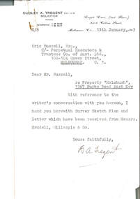
Document, re Property "Holmbush", 1267 Burke Road East Kew, 1943
... re Property "Holmbush", 1267 Burke Road East Kew... Property "Holmbush", 1267 Burke Road East Kew Document ...Formal identification of the property to be bought as the first Melbourne Legacy residence sent to Legatee E. Russell, Chair of the Hostel Committee. The survey is hand drawn and meticulously measured.The documents demonstrate business practices in the 1940s with regard to the purchase of property, as well as being an important record of the first property to be purchased by Melbourne Legacy as a residence for children.00310.1 Letter from Dudley A. Tregent, Solicitor, dated 15 January 1943, to Legatee E. Russell, Chair of the Hostel Committee, enclosing the survey sketch plan. White paper, black letterhead and typing, two holes punched for filing 00310.2 Survey sketch plan by Meudell, Gillespie & Co, dated 13 January 1943. Black type and printing, with some red shading and writing, on white foolscap paper. 00310.3 Letter from Meudell, Gillespie & Co to Mr. D.A. Tregent, Solicitor. Quarto, black typing, red underlining, on white.00310.1 Signed by D.A. Tregent 00310.2 Signed by Percival A. Jordan 00310.3 Signed by Percival A. Jordanholmbush initial negotiations, properties, holmbush -
 Melbourne Legacy
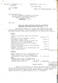
Letter - Document, letter, re D. N. Craig and Others from W.G. Thomson / Property 1267 Burke Road, East Kew, 1943
... Burke Road, East Kew... / Property 1267 Burke Road, East Kew Letter Document, letter ...Letter from Dudley A Tregent, Solicitor showing an outline of the final payment required for purchase of the Holmbush property, including stamp duty, transfer of Title fees and Council Rates. A record of the costs of acquiring property as well as being an important record of the first property to be purchased by Melbourne Legacy as a residence for children.Quarto copy paper, black and white, two hole punched for filing.holmbush initial negotiations, holmbush, properties -
 Melbourne Legacy
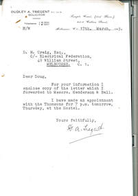
Letter - Document, letter, re Property 1267 Burke Road, East Kew, 1943
... re Property 1267 Burke Road, East Kew... for filing. re Property 1267 Burke Road, East Kew Letter Document ...00331.1 A copy of the letter from the solicitor to the real estate agents that handled the transaction to claim for the return of items included in the purchase of the Holmbush property that were removed by the previous owner. 00331.2 A note to accompany the copy of the letter.Business practices in the 1940s around the purchase of the first property by Melbourne Legacy as a residence for children.00331.1 Quarto white copy paper, black type, two hole punched for filing. 00331.2 White note paper, black type, two hole punched for filing.holmbush initial negotiations, holmbush -
 Kew Historical Society Inc
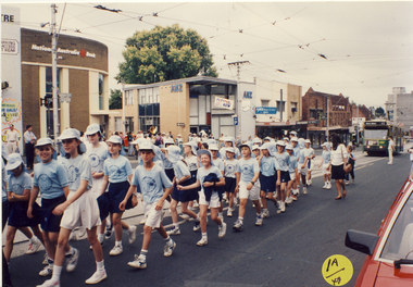
Photograph, St Anne's East Kew, Kew Festival, 1992
... St Anne's East Kew, Kew Festival... East Kew, Kew Festival Photograph Photograph ...The Kew Festival began in 1974. A feature of many festivals were the festival parades in which community groups participated. None of the photographs in the album are named so KHS welcomes viewers to identify participants and or locations.Photograph from an album depicting participants in the 1992 Kew Festivalkew festival - 1992 -
 Kew Historical Society Inc
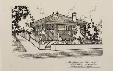
Drawing - Property Illustration, Margaret Picken, 30 Belford Road, Kew East, 1990
... 30 Belford Road, Kew East....30 belford road - kew east (vic).... east (vic). 30 BELFORD RD., KEW / MARGARET PICKEN '90 ...After training as a Cartographic Draftsman within the mining industry, I worked as a property illustrator for real estate firms in the eastern suburbs of Melbourne for 23 years from 1983. I initially photographed houses with a Polaroid camera and made a 'thumbnail' sketch while there. The photos were used to scale off a sketch in pencil and then that sketch was overlaid with drafting film and the 'pen and ink' completed. The pens I used were the Rotring ‘Rapidigraph’ drafting pens. The ink was also made by Rotring (German).The film was ‘Rapidraw’, polyester drafting film, double matte. It takes a very fine line and doesn’t bleed. As well as house sketches, there were often floor plans and site plans ordered. Aerial sketches were ordered when the property needed an overall view. (Margaret Picken, 2020)This drawing is one of a series created by Margaret Picken for a range of real estate agents in Melbourne between c.1983 and c.2005. Each work is signed and dated by the artist.Gift of Margaret Picken, 2020Pen and ink drawing on drafting film of 30 Belford Road, Kew by Margaret Picken.30 BELFORD RD., KEW / MARGARET PICKEN '90 / WOODARDS ~ KEWartist -- margaret picken 1950-, architectural drawings -- houses -- kew (vic.), 30 belford road - kew east (vic). -
 Kew Historical Society Inc
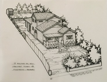
Drawing - Property Illustration, Margaret Picken, 28 Belford Road, Kew East, 1998
... 28 Belford Road, Kew East....28 belford road - kew east (vic).... east (vic). 28 BELFORD RD., KEW / MARGARET PICKEN '98/ WOODARDS ...After training as a Cartographic Draftsman within the mining industry, I worked as a property illustrator for real estate firms in the eastern suburbs of Melbourne for 23 years from 1983. I initially photographed houses with a Polaroid camera and made a 'thumbnail' sketch while there. The photos were used to scale off a sketch in pencil and then that sketch was overlaid with drafting film and the 'pen and ink' completed. The pens I used were the Rotring ‘Rapidigraph’ drafting pens. The ink was also made by Rotring (German).The film was ‘Rapidraw’, polyester drafting film, double matte. It takes a very fine line and doesn’t bleed. As well as house sketches, there were often floor plans and site plans ordered. Aerial sketches were ordered when the property needed an overall view. (Margaret Picken, 2020)This drawing is one of a series created by Margaret Picken for a range of real estate agents in Melbourne between c.1983 and c.2005. Each work is signed and dated by the artist.Gift of Margaret Picken, 2020Pen and ink drawing on drafting film of 28 Belford Road, Kew by Margaret Picken.28 BELFORD RD., KEW / MARGARET PICKEN '98/ WOODARDS ~ HAWTHORNartist -- margaret picken 1950-, architectural drawings -- houses -- kew (vic.), 28 belford road - kew east (vic). -
 Kew Historical Society Inc
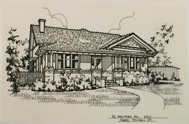
Drawing - Property Illustration, Margaret Picken, 96 Belford Road, Kew East, 1987
... 96 Belford Road, Kew East....96 belford road - kew east (vic).... east (vic). 96 BELFORD RD., KEW / MARG PICKEN '87 Pen and ink ...After training as a Cartographic Draftsman within the mining industry, I worked as a property illustrator for real estate firms in the eastern suburbs of Melbourne for 23 years from 1983. I initially photographed houses with a Polaroid camera and made a 'thumbnail' sketch while there. The photos were used to scale off a sketch in pencil and then that sketch was overlaid with drafting film and the 'pen and ink' completed. The pens I used were the Rotring ‘Rapidigraph’ drafting pens. The ink was also made by Rotring (German).The film was ‘Rapidraw’, polyester drafting film, double matte. It takes a very fine line and doesn’t bleed. As well as house sketches, there were often floor plans and site plans ordered. Aerial sketches were ordered when the property needed an overall view. (Margaret Picken, 2020)This drawing is one of a series created by Margaret Picken for a range of real estate agents in Melbourne between c.1983 and c.2003. Each work is signed and dated by the artist.Gift of Margaret Picken, 2020Pen and ink drawing on drafting film of 96 Belford Road, Kew by Margaret Picken.96 BELFORD RD., KEW / MARG PICKEN '87artist -- margaret picken 1950-, architectural drawings -- houses -- kew (vic.), 96 belford road - kew east (vic). -
 Kew Historical Society Inc
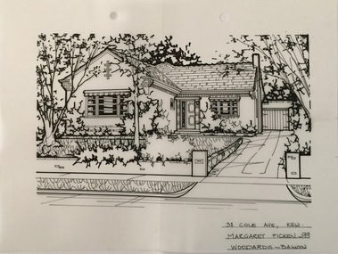
Drawing - Property Illustration, Margaret Picken, 38 Cole Avenue, Kew East, 1999
... 38 Cole Avenue, Kew East....38 cole avenue - kew east (vic)....- architectural drawings -- houses -- kew (vic.) 38 cole avenue - kew east ...After training as a Cartographic Draftsman within the mining industry, I worked as a property illustrator for real estate firms in the eastern suburbs of Melbourne for 23 years from 1983. I initially photographed houses with a Polaroid camera and made a 'thumbnail' sketch while there. The photos were used to scale off a sketch in pencil and then that sketch was overlaid with drafting film and the 'pen and ink' completed. The pens I used were the Rotring ‘Rapidigraph’ drafting pens. The ink was also made by Rotring (German).The film was ‘Rapidraw’, polyester drafting film, double matte. It takes a very fine line and doesn’t bleed. As well as house sketches, there were often floor plans and site plans ordered. Aerial sketches were ordered when the property needed an overall view. (Margaret Picken, 2020)This drawing is one of a series created by Margaret Picken for a range of real estate agents in Melbourne between c.1983 and c.2005. Each work is signed and dated by the artist.Gift of Margaret Picken, 2020Pen and ink architectural drawing on drafting film of 38 Cole Avenue, Kew by Margaret Picken.38 COLE AVE., KEW / MARGARET PICKEN ~99 / WOODARDS ~ BALWYNartist -- margaret picken 1950-, architectural drawings -- houses -- kew (vic.), 38 cole avenue - kew east (vic). -
 Kew Historical Society Inc
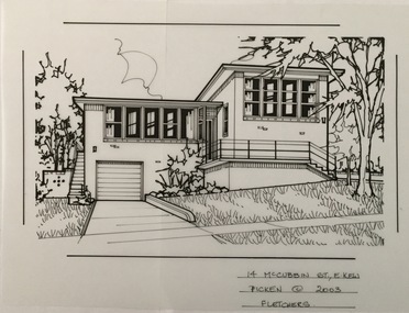
Drawing - Property Illustration, Margaret Picken, 14 McCubbin Street, Kew East, 2003
... 14 McCubbin Street, Kew East...14 mccubbin street - kew east (vic).... east (vic). 14 McCUBBIN ST., E. KEW / PICKEN © 2003 / FLETCHERS ...After training as a Cartographic Draftsman within the mining industry, I worked as a property illustrator for real estate firms in the eastern suburbs of Melbourne for 23 years from 1983. I initially photographed houses with a Polaroid camera and made a 'thumbnail' sketch while there. The photos were used to scale off a sketch in pencil and then that sketch was overlaid with drafting film and the 'pen and ink' completed. The pens I used were the Rotring ‘Rapidigraph’ drafting pens. The ink was also made by Rotring (German).The film was ‘Rapidraw’, polyester drafting film, double matte. It takes a very fine line and doesn’t bleed. As well as house sketches, there were often floor plans and site plans ordered. Aerial sketches were ordered when the property needed an overall view. (Margaret Picken, 2020)This drawing is one of a series created by Margaret Picken for a number of real estate agents in Melbourne between 1983 and 2005. Each work is signed and dated by the artist.Gift of Margaret Picken, 2020Pen and ink architectural drawing on drafting film of14 McCubbin Street, Kew by Margaret Picken.14 McCUBBIN ST., E. KEW / PICKEN © 2003 / FLETCHERSartist -- margaret picken 1950-, architectural drawings -- houses -- kew (vic.), 14 mccubbin street - kew east (vic). -
 Kew Historical Society Inc
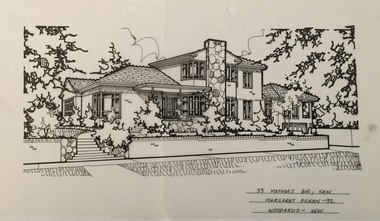
Drawing - Property Illustration, Margaret Picken, 33 Mathers Avenue, Kew East, 1992
... 33 Mathers Avenue, Kew East...33 mathers avenue - kew east (vic).... east (vic). 33 MATHERS AVE., KEW / MARGARET PICKEN ~92 ...After training as a Cartographic Draftsman within the mining industry, I worked as a property illustrator for real estate firms in the eastern suburbs of Melbourne for 23 years from 1983. I initially photographed houses with a Polaroid camera and made a 'thumbnail' sketch while there. The photos were used to scale off a sketch in pencil and then that sketch was overlaid with drafting film and the 'pen and ink' completed. The pens I used were the Rotring ‘Rapidigraph’ drafting pens. The ink was also made by Rotring (German).The film was ‘Rapidraw’, polyester drafting film, double matte. It takes a very fine line and doesn’t bleed. As well as house sketches, there were often floor plans and site plans ordered. Aerial sketches were ordered when the property needed an overall view. (Margaret Picken, 2020)This drawing is one of a series created by Margaret Picken for a number of real estate agents in Melbourne between 1983 and 2005. Each work is signed and dated by the artist.Gift of Margaret Picken, 2020Pen and ink architectural drawing on drafting film of 33 Mathers Avenue, Kew by Margaret Picken.33 MATHERS AVE., KEW / MARGARET PICKEN ~92 / WOODARDS ~ KEWartist -- margaret picken 1950-, architectural drawings -- houses -- kew (vic.), 33 mathers avenue - kew east (vic). -
 Kew Historical Society Inc
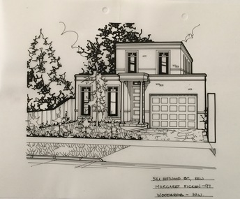
Drawing - Property Illustration, Margaret Picken, 54A Hartwood Street, Kew East, 1997
... 54A Hartwood Street, Kew East...54a hartwood street - kew east (vic)... east (vic) 54A HARTWOOD ST., KEW / MARGARET PICKEN ~97 ...After training as a Cartographic Draftsman within the mining industry, I worked as a property illustrator for real estate firms in the eastern suburbs of Melbourne for 23 years from 1983. I initially photographed houses with a Polaroid camera and made a 'thumbnail' sketch while there. The photos were used to scale off a sketch in pencil and then that sketch was overlaid with drafting film and the 'pen and ink' completed. The pens I used were the Rotring ‘Rapidigraph’ drafting pens. The ink was also made by Rotring (German).The film was ‘Rapidraw’, polyester drafting film, double matte. It takes a very fine line and doesn’t bleed. As well as house sketches, there were often floor plans and site plans ordered. Aerial sketches were ordered when the property needed an overall view. (Margaret Picken, 2020)This drawing is one of a series created by Margaret Picken for a number of real estate agents in Melbourne between 1983 and 2005. Each work is signed and dated by the artist.Gift of Margaret Picken, 2020Pen and ink architectural drawing on drafting film of 54A Hartwood Street, Kew by Margaret Picken.54A HARTWOOD ST., KEW / MARGARET PICKEN ~97 / WOODARDS ~ HAWartist -- margaret picken 1950-, architectural drawings -- houses -- kew (vic.), 54a hartwood street - kew east (vic) -
 Kew Historical Society Inc
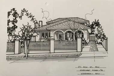
Drawing - Property Illustration, Margaret Picken, 571 High Street, Kew East, 1994
... 571 High Street, Kew East...571 high street - kew east (vic).... east (vic). 571 HIGH ST., KEW / MARGARET PICKEN ~94 / WOODARDS ...After training as a Cartographic Draftsman within the mining industry, I worked as a property illustrator for real estate firms in the eastern suburbs of Melbourne for 23 years from 1983. I initially photographed houses with a Polaroid camera and made a 'thumbnail' sketch while there. The photos were used to scale off a sketch in pencil and then that sketch was overlaid with drafting film and the 'pen and ink' completed. The pens I used were the Rotring ‘Rapidigraph’ drafting pens. The ink was also made by Rotring (German).The film was ‘Rapidraw’, polyester drafting film, double matte. It takes a very fine line and doesn’t bleed. As well as house sketches, there were often floor plans and site plans ordered. Aerial sketches were ordered when the property needed an overall view. (Margaret Picken, 2020)This drawing is one of a series created by Margaret Picken for a number of real estate agents in Melbourne between 1983 and 2005. Each work is signed and dated by the artist.Gift of Margaret Picken, 2020Pen and ink drawing on drafting film of 571 High Street, Kew by Margaret Picken.571 HIGH ST., KEW / MARGARET PICKEN ~94 / WOODARDS ~ KEWartist -- margaret picken 1950-, architectural drawings -- houses -- kew (vic.), 571 high street - kew east (vic). -
 Kew Historical Society Inc
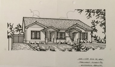
Drawing - Property Illustration, Margaret Picken, 585 & 587 High Street, Kew East, 1992
... 585 & 587 High Street, Kew East...585 & 587 high street - kew east (vic).... - kew east (vic). 585 + 587 HIGG ST., KEW / MARGARET PICKEN ~92 ...After training as a Cartographic Draftsman within the mining industry, I worked as a property illustrator for real estate firms in the eastern suburbs of Melbourne for 23 years from 1983. I initially photographed houses with a Polaroid camera and made a 'thumbnail' sketch while there. The photos were used to scale off a sketch in pencil and then that sketch was overlaid with drafting film and the 'pen and ink' completed. The pens I used were the Rotring ‘Rapidigraph’ drafting pens. The ink was also made by Rotring (German).The film was ‘Rapidraw’, polyester drafting film, double matte. It takes a very fine line and doesn’t bleed. As well as house sketches, there were often floor plans and site plans ordered. Aerial sketches were ordered when the property needed an overall view. (Margaret Picken, 2020)This drawing is one of a series created by Margaret Picken for a number of real estate agents in Melbourne between 1983 and 2005. Each work is signed and dated by the artist.Gift of Margaret Picken, 2020Pen and ink architectural drawing on drafting film of 585 & 587 High Street, Kew by Margaret Picken.585 + 587 HIGG ST., KEW / MARGARET PICKEN ~92 / WOODARDS ~ BALWYNartist -- margaret picken 1950-, architectural drawings -- houses -- kew (vic.), 585 & 587 high street - kew east (vic). -
 Kew Historical Society Inc
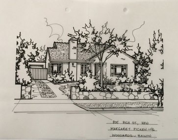
Drawing - Property Illustration, Margaret Picken, 805 High Street, Kew East, 1996
... 805 High Street, Kew East...805 high street - kew east (vic)... east (vic) 805 HIGH ST., KEW / MARGARET PICKEN ~96 / WOODARDS ...After training as a Cartographic Draftsman within the mining industry, I worked as a property illustrator for real estate firms in the eastern suburbs of Melbourne for 23 years from 1983. I initially photographed houses with a Polaroid camera and made a 'thumbnail' sketch while there. The photos were used to scale off a sketch in pencil and then that sketch was overlaid with drafting film and the 'pen and ink' completed. The pens I used were the Rotring ‘Rapidigraph’ drafting pens. The ink was also made by Rotring (German).The film was ‘Rapidraw’, polyester drafting film, double matte. It takes a very fine line and doesn’t bleed. As well as house sketches, there were often floor plans and site plans ordered. Aerial sketches were ordered when the property needed an overall view. (Margaret Picken, 2020)This drawing is one of a series created by Margaret Picken for a number of real estate agents in Melbourne between 1983 and 2005. Each work is signed and dated by the artist.Gift of Margaret Picken, 2020Pen and ink architectural drawing on drafting film of 805 High Street, Kew by Margaret Picken.805 HIGH ST., KEW / MARGARET PICKEN ~96 / WOODARDS ~ BALWYNartist -- margaret picken 1950-, architectural drawings -- houses -- kew (vic.), 805 high street - kew east (vic) -
 Kew Historical Society Inc
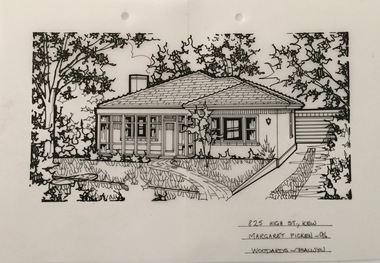
Drawing - Property Illustration, Margaret Picken, 825 High Street, Kew East, 1996
... 825 High Street, Kew East...825 high street - kew east (vic).... east (vic). 825 HIGH ST., KEW / MARGARET PICKEN ~96 / WOODARDS ...After training as a Cartographic Draftsman within the mining industry, I worked as a property illustrator for real estate firms in the eastern suburbs of Melbourne for 23 years from 1983. I initially photographed houses with a Polaroid camera and made a 'thumbnail' sketch while there. The photos were used to scale off a sketch in pencil and then that sketch was overlaid with drafting film and the 'pen and ink' completed. The pens I used were the Rotring ‘Rapidigraph’ drafting pens. The ink was also made by Rotring (German).The film was ‘Rapidraw’, polyester drafting film, double matte. It takes a very fine line and doesn’t bleed. As well as house sketches, there were often floor plans and site plans ordered. Aerial sketches were ordered when the property needed an overall view. (Margaret Picken, 2020)This drawing is one of a series created by Margaret Picken for a number of real estate agents in Melbourne between 1983 and 2005. Each work is signed and dated by the artist.Gift of Margaret Picken, 2020Pen and ink architectural drawing on drafting film of 825 High Street, Kew by Margaret Picken.825 HIGH ST., KEW / MARGARET PICKEN ~96 / WOODARDS ~ BALWYNartist -- margaret picken 1950-, architectural drawings -- houses -- kew (vic.), 825 high street - kew east (vic). -
 Kew Historical Society Inc
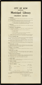
Document, City of Kew, City of Kew Municipal Library, Children's Section, 1953
... kew public library - east kew (vic)... opening hours of the Kew and East Kew branches.... - east kew (vic) city of kew - library guidelines Original framed ...1860: Kew's first library was the Kew Literary and Scientific Society, which opened on 6 August 1860. 1884: Kew Town Hall was extended and the library transferred to a room on the upper floor. This was not an ideal arrangement as the room was required for Council purposes. 1904: A cottage adjoining Kew Town Hall was purchased for use as a library. 1937: The library was closed for a major overhaul of stock and renovation of the building. It reopened in December 1937 and remained there for more than 35 years. 1973: When the Civic Centre opened in Charles Street, Kew, the library moved in. 1987: Kew Library moved to its current location in the converted city hall, overlooking the beautiful Alexandra Gardens. The library was officially opened at this site on Friday 23 October 1987 by the Mayor of Kew, Cr James Tutt. (Source: Boroondara Library Services)Historically and socially significant set of regulations governing the use of the children's library in Kew in the early 1950sOriginal framed rules and regulations of the junior section of the Kew Library, dated 16.6.1953, authorised by the Mayor (W.E.R. Hope) and Town Clerk (W.D.Birrell). The document also lists opening hours of the Kew and East Kew branches.kew public library - kew (vic), kew public library - east kew (vic), city of kew - library guidelines -
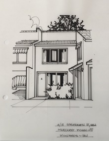 Kew Historical Society Inc
Drawing - Property Illustration, Margaret Picken, 4/18 Strathalbyn Street, Kew East, 1997
... 4/18 Strathalbyn Street, Kew East... Strathalbyn Street, Kew East by Margaret Picken.... of 4/18 Strathalbyn Street, Kew East by Margaret Picken. 4/18 ...After training as a Cartographic Draftsman within the mining industry, I worked as a property illustrator for real estate firms in the eastern suburbs of Melbourne for 22 years from 1983. I initially photographed houses with a Polaroid camera and made a 'thumbnail' sketch while there. The photos were used to scale off a sketch in pencil and then that sketch was overlaid with drafting film and the 'pen and ink' completed. The pens I used were the Rotring ‘Rapidigraph’ drafting pens. The ink was also made by Rotring (German).The film was ‘Rapidraw’, polyester drafting film, double matte. It takes a very fine line and doesn’t bleed. As well as house sketches, there were often floor plans and site plans ordered. Aerial sketches were ordered when the property needed an overall view. (Margaret Picken, 2020)This drawing is one of a series created by Margaret Picken for a number of real estate agents in Melbourne between 1983 and 2005. Each work is signed and dated by the artist.Gift of Margaret Picken, 2020Pen and ink architectural drawing on drafting film of 4/18 Strathalbyn Street, Kew East by Margaret Picken.4/18 STRATHALBYN ST., KEW / MARGARET PICKEN ~97 / WOODARDS ~ HAWartist -- margaret picken 1950-, architectural drawings -- houses -- kew (vic.), 4/18 strathalbyn street - kew (vic) -
 Kew Historical Society Inc
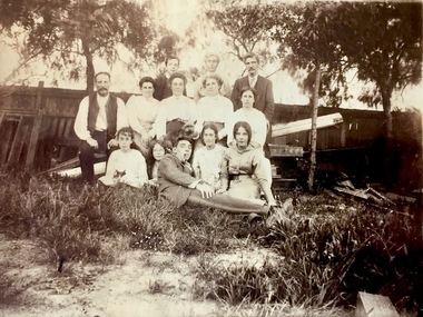
Photograph - Bennett Family Gathering, 22 Harp Road
... ) of 22 Harp Road, East Kew, in whose yard the photograph... Road, East Kew. ..., East Kew, in whose yard the photograph was taken. A year before ...In 1980, Mr Laurie Bennett presented the Kew Historical Society with a number of photographs and postcards from the estate of his mother Eileen Mary Bennett (nee Clark). His mother was the daughter of Lawrence FH Clark(?-1946) and Mary Clark (?-1925) of 22 Harp Road, East Kew, in whose yard the photograph was taken. A year before the donation occurred a notice appeared in the Canberra Times stating that: "BENNETT, Eileen Mary. — May 8th at Tuross Heads, N.S.W. Late of 22 Harp Rd, East Kew, (Vic). Dearly loved wife of the late Harold Bennett, loved mother and mother in law of Laurie and Shirley (Melbourne), Kevin and Doreen (Canberra), grandmother of Linda, Stephen, Paul, Gabrielle, Peter, Mark and Jon."Part of a large collection of photographs and postcards in the collectionFamily portrait of members of the Bennett family of 22 Harp Road, East Kew. laurie bennett, eileen mary bennett, eileen mary clark -
 Kew Historical Society Inc
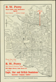
Map - Map of Kew and Hawthorn Districts
... Map of Kew, East Kew and Hawthorn produced for a Kew Real..., East Kew... of Kew, East Kew and Hawthorn produced for a Kew Real Estate ...Map of Kew, East Kew and Hawthorn produced for a Kew Real Estate Agent, RW Perry. The map is undated.Two-colour map of Kew and Hawthorn Districts produced for by R.L. Jarrett for RW Perry, Real Estate & Insurance Agent. The map has unusual features such as a planned railway link from Kew Station to the former Outer Circle Railway. RW Perry / Real Estate & Insurance Agent, 602 High Street, East Kewmaps - kew (vic), maps - hawthorn (vic), r.w. perry, real estate agents -- kew (vic.) -
 Kew Historical Society Inc
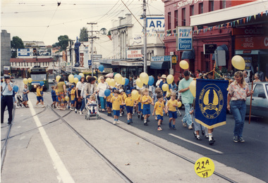
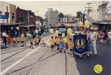
Photograph, Kew East Primary School, Kew Festival, 1992
... Kew East Primary School, Kew Festival... an album depicting participants in the 1992 Kew Festival Kew East ...The Kew Festival began in 1974. A feature of many festivals were the festival parades in which community groups participated. None of the photographs in the album are named so KHS welcomes viewers to identify participants and or locations.Photograph from an album depicting participants in the 1992 Kew Festivalkew festival - 1992 -
 Kew Historical Society Inc
Photograph, Kew East Primary School, Kew Festival, 1992
... Kew East Primary School, Kew Festival... an album depicting participants in the 1992 Kew Festival Kew East ...The Kew Festival began in 1974. A feature of many festivals were the festival parades in which community groups participated. None of the photographs in the album are named so KHS welcomes viewers to identify participants and or locations.Photograph from an album depicting participants in the 1992 Kew Festivalkew festival - 1992 -
 Ballarat Heritage Services
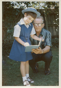
Photograph - Photograph - Colour, Ann Gervasoni and Gus Gervasoni
... st anne's east kew.... Ann is wearing the old St Anne's East Kew summer uniform... first day of school st anne's east kew Colour photograph of Ann ...Colour photograph of Ann Gervasoni posing for a photograph with her Grandfather, Gus Gervasoni, on the first day of school. Ann is wearing the old St Anne's East Kew summer uniform. The winter uniform was the same, but the tunic was in wool, and the grey shirt had long sleeves. It was worn with a blue jumper and blazer.gus gervasoni, ann gervasoni, school uniform, first day of school, st anne's east kew -
 Ballarat Heritage Services
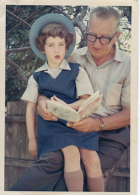
Photograph, Clare Gervasoni and Gus Gervasoni
... st anne's east kew... of school. Clare is wearing the old St Anne's East Kew summer... first day of school st anne's east kew Colour photograph ...Colour photograph of Clare Gervasoni posing for a photograph with her Grandfather, Gus Gervasoni, on the first day of school. Clare is wearing the old St Anne's East Kew summer uniform. The winter uniform was the same, but the tunic was in wool, and the grey shirt had long sleeves. It was worn with a blue jumper and blazer, and in winter a tie.gus gervasoni, ann gervasoni, school uniform, first day of school, st anne's east kew -
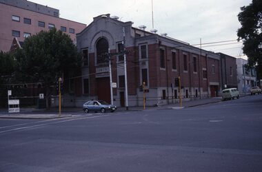 Melbourne Tram Museum
Slide - Set of 23 - MMTB Tram substations and offices, Robert Green, 3/1990
... East Kew... North Fitzroy 13 - Holden St North Fitzroy 14 - East Kew - High... 13 - Holden St North Fitzroy 14 - East Kew - High St. 15 ...Set of 23 colour slides of MMTB tramway substations and the Victoria St Office, by Robert Green Mar 1990. 1 - Carlton Substation - Queensberry St. 2 - Carlton Substation - Queensberry St. 3 - Coburg - Moore St 4 - Glen Huntly Depot substation 5 - Fitzroy - Young St. 6 - Fitzroy - Young St. 7 - Station St Camberwell 8 - Malvern Tram depot 9 - Brunswick Rd, Brunswick 10 - Brunswick Rd, Brunswick 11 - Brunswick Rd, Brunswick 12 - Holden St North Fitzroy 13 - Holden St North Fitzroy 14 - East Kew - High St. 15 - East Kew - High St. 16 - East Kew - High St. 17 - East Kew - High St. 18 - Little Bourke St Melbourne 19 - Former branch offices - Victoria Parade Fitzroy 20 - Former branch offices - Victoria Parade Fitzroy 21 - Former branch offices - Victoria Parade Fitzroy 22 - Former branch offices - Victoria Parade Fitzroy - 2004 23 - Former branch offices - Victoria Parade Fitzroy = 2004Yields information about Melbourne tramway substationsSet of 23 Kodak colour slides in plastic mounts.All slides have their location marked on them in black ink.tramways, mmtb, substations, carlton, queensberry st, coburg, glen huntly, north fitzroy, young st, camberwell, malvern depot, brunswick road, brunswick, holden st, east kew, little bourke st, branch offices, victoria parade -
 Ballarat Heritage Services
Photograph - Colour, Kathleen Gervasoni, Birthday Party, c1972, c1972
... St Anne's East Kew Uniform... of the partygoers wear the uniform of St Anne's East Kew. Left to right...). Some of the partygoers wear the uniform of St Anne's East Kew ...Colour photograph of Ann Gervasoni's birthday party held at 93 Willsmere Road Kew (behind North Kew Newsagency). Some of the partygoers wear the uniform of St Anne's East Kew. Left to right: Clare Gervasoni, Sally Ann Estella, Ann Gervasoni, Lisa Gervasoni (red jumper), Eve Urban, Genevieve Rayson.birthday, gervasoni, birthday cake, st anne's east kew uniform -
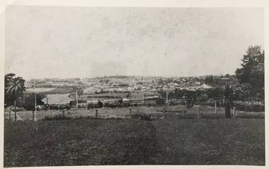 Kew Historical Society Inc
Photograph, Kew looking East to Deepdene, c.1905
... Kew looking East to Deepdene...Kew looking east towards Deepdene. Before 1909. ... looking east towards Deepdene. Before 1909. Kew looking East ...Kew looking east towards Deepdene. Before 1909. The reverse of the photograph includes an analysis of the photo and the places that can be seen within it (eg Deepdene Station, first Deepdene School, Burke Road etc)deepdene, farming (kew) -
 Kew Historical Society Inc
Functional object, Presentation Wallet : G Thake, Founder E.K.W.C, 1946
... east kew women's club... club: the East Kew Women’s Community Club. The article reads...: the East Kew Women’s Community Club. The article reads: "Wives ...On Saturday 17 May 1947, an article on page 25 of the Australian Women’s Weekly reported on the formation of a new women's club: the East Kew Women’s Community Club. The article reads: "Wives and mothers in a Melbourne suburb, East Kew, have formed the East Kew Women's Community Club. While babies and young children are under the supervision of a play leader, wives and mothers follow up their own interests. The club caters for varying tastes, has musical appreciation, drama, and "Keep Fit" classes. President Mrs. Grace Thake says that the club hopes soon to have tennis, debating, and discussion groups. The club originated from a debate, "Should women take an active part in social and civic affairs?" Two days later their interest in these matters was proved by the forming of the club, which took for its motto: "To help others, improve ourselves, and foster the community spirit." Membership is open to all women, regardless of age, politics, and religion, and aims to co-operate with all societies working for the improvement of health and cultural standards." The East Kew Women's Community Club, also called the East Kew Women's Community Club functioned from 1946 to the end of the 1960s (to be verified). The records of the Club were placed with Kew Historical Society to preserve them for posterity. The records and objects belonging to the East Kew Women's Community Club have significance socially for their capacity to illuminate women's associations in the post war period in Australia.Brown leather wallet, dated 1946, embossed with the owner's name and information about the club of which she was the founding president."G Thake | Founder EKWC | 1946 To help others | Improve ourselves | Foster the community spirit"community clubs - kew (vic), women's clubs - kew (vic), east kew women's club, grace thake, presentation wallets -
 Kew Historical Society Inc
Photograph - Flooding of the Yarra Valley at Kew East, 1974
... Flooding of the Yarra Valley at Kew East... of the Yarra bordering Kew and Kew East in the north and west... bordering Kew and Kew East in the north and west of the municipality ...Flooding of the Yarra Valley, including that section of the Yarra bordering Kew and Kew East in the north and west of the municipality, was a regular occurrence. Extreme flood events of the Yarra River are recorded to have occurred in 1891, 1901, 1916, 1923 and 1934. The Municipality of Kew's response to these floods was to enact planning decisions restricting residential development in flood prone areas following the floods of 1916, 1921 and 1934. While floods continued after the development of the Upper Yarra Reservoir (construction 1948-57), the regularity and extent of these inundations diminished. During the nineteenth century, the land abutting the south side of the Yarra in Kew was devoted to dairy farming. In the twentieth century, before and after the construction of the Eastern Freeway, much of this low-lying area was used as golf courses and public parks.Late example of the capacity of the Yarra Valley at Kew to flood, even though drainage works and the Upper Yarra Reservoir had reduced their regularity.Original black and white print photograph of Hay's Paddock under floodwater on 16 May 1974. The vantage point of the photographer is Keystone Crescent looking east. Flooding was caused by overflowing water in Glass' Creek and the River Yarra. Annotation verso: "Keystone Cr looking east / 16 May 1974 11.50am"hays paddock, floods, yarra river, glass' creek -
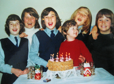
 Ballarat Heritage Services
Photograph, Birthday Party, 1969, c1969
... St Anne's East Kew uniform... the uniform of St Anne's East Kew, and an apron. Left to right... Anne's East Kew uniform Five girls celebrate the birthday ...Five girls celebrate the birthday of Clare Gervasoni at her home, 93 Willsmere Road, North Kew (behind North Kew Newsagency). A cake featurers seven lit candles, there are Marchants Lemonade bottles and a bowl of jelly on the table. Most of the girls wear the uniform of St Anne's East Kew, and an apron. Left to right: ? Martina ?, Clare Gervasoni, Brigid DeNeefe, Yvonne Brosolo (cut off) birthday, clare gervasoni, brigid deneefe, st anne's east kew uniform