Showing 1938 items
matching floods
-
 Greensborough Historical Society
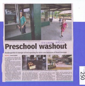
Newspaper clipping, Diamond Valley Leader, Preschool washout, 25/01/2012
... floods ...Half page article on damage from floods on Christmas Day 2011. Noting in particular damage to Briar Hill Preschool.A further reference to the Christmas Day 2011 floods.Half page newspaper article featuring 2 coloured photographs. D V Leader 25/1/12 in biro.christmas day 2011, floods, briar hill preschool, tom melican -
 Orbost & District Historical Society
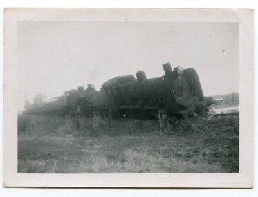
black and white photographs, 1950s
Dudley Charles Seymour Courtney , with a fellow worker, was trapped on the Orbost Raailwaay Station roof until rescued by an army duck. These photographs were his. He worked on the railway in Orbost from 1942 - 1952 approximately. During the 1952 flood nearly half of Orbost rail way station is washed away. The stationmaster and four members of his staff were rescued by police using army ducks.This is a pictorial record of a significant event in the history of Orbost.Nine small black / white photographs of a derailed train at a railway station. Derailed trucks and floodwaters can be seen. The photographs have a narrow white frame. Some are portrait and others landscape.on back of 3082.8 - hand-written in blue pen :"The floods worked the line from under the trucks in a couple of hours"floods-orbost orbost-railway-station rescue courtney-dudley-charles-seymour -
 Eltham District Historical Society Inc
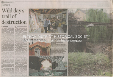
Newsclipping, Reid Sexton, Wild day's trail of destruction, The Age, Tuesday, December 27, pp4-5, 2011
... floods ...A late afternoon storm on Christmas Day 2011. A flash flood occurred from significant rain fall and hail, which accumulated along an old waterway with floodwater submerging cars along Valonia Drive then down Grove Street flooding houses, through the Bible Street Reserve where it then submerged Main Road washing away the small railway trestle bridge opposite the reserve then flooding the Judge Book Village before finally entering the Diamond Creek. Widespread damage occured from hail and flash flooding.fay bridge collection, eltham, 2011-12-27, flood damage, floods, floodwater -
 Eltham District Historical Society Inc
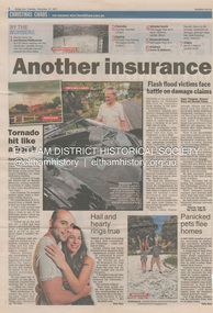
Newsclipping, Angus Thompson et al, Another insurance storm brews, Herald Sun, Tuesday, December 27, pp4-5, 2011
... floods ...A late afternoon storm on Christmas Day 2011. A flash flood occurred from significant rain fall and hail, which accumulated along an old waterway with floodwater submerging cars along Valonia Drive then down Grove Street flooding houses, through the Bible Street Reserve where it then submerged Main Road washing away the small railway trestle bridge opposite the reserve then flooding the Judge Book Village before finally entering the Diamond Creek. Widespread damage occured from hail and flash flooding.fay bridge collection, eltham, 2011-12-27, flood damage, floods, floodwater -
 Sunbury Family History and Heritage Society Inc.
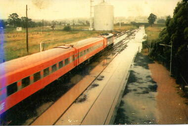
Photograph, 17 December 1985
On 17th December 1985 record torrential rain fell in Sunbury, which flooded the main Melbourne Bendigo rail line and disrupted traffic. The photograph is looking to the north of the station and takes in the historic Macedon Street bridge and the open ground with the storage silo on the west side of the railway line. A coloured photograph of a former V Line train stopped at a station where the railway line has been flooded. A storage silo occupies vac ant ground adjacent to the railway line.sunbury railway station, storage silos, horne street -
 University of Melbourne, Burnley Campus Archives
Photograph - Black and white print, Flood in Orchard, 1934
This photograph was sent to Burnley in an envelope printed, "On His Majesty's Service" Centenary Celebrations State of Victoria & City of Melbourne 1934-35 Department of Agriculture, Melbourne and handwritten on it "Flood in orchard 1/12/1934 Mr. Jessep." Note by T.H. Kneen 8 April 1992, "Alex Jessep (left) with Tom Trahair. Periodically Tom would take leave to go back to his home town Yackandandah to test a new theory to find the lost gold seam at the Little Waterloo mine."Black and white photograph. George Russ and Frank Ellery examining the ground by the flooded river. Uprooted trees behind them.This photograph was sent to Burnley in an envelope printed, "On His Majesty's Service" Centenary Celebrations State of Victoria & City of Melbourne 1934-35 Department of Agriculture, Melbourne and handwritten on it "Flood in orchard 1/12/1934 Mr. Jessep."george russ, frank ellery, centenary celebrations, orchard, tom trahair, 1934 flood, alex jessep, uprooted trees -
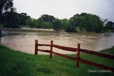
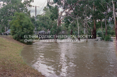
 Eltham District Historical Society Inc
Photograph, Floodwaters, Diamond Creek, Eltham, 1934
... floods ...The Diamond Creek in flood near the Main Road bridge at Eltham, Victoria. The Yarra also was in flood. In early December 1934 the "Greatest flood in the history of the Yarra" occured, according to The Argus newspaper. Bridges and houses were swept away with hundreds of people left homeless across the state. The historic 1934 flood of the Diamond Creek and Yarra River set the criteria for future planning with respect to flood water rise.This photo forms part of a collection of photographs gathered by the Shire of Eltham for their centenary project book, "Pioneers and Painters: 100 years of the Shire of Eltham" by Alan Marshall (1971). The collection of over 500 images is held in partnership between Eltham District Historical Society and Yarra Plenty Regional Library (Eltham Library) and is now formally known as 'The Shire of Eltham Pioneers Photograph Collection.' It is significant in being the first community sourced collection representing the places and people of the Shire's first one hundred years.Digital image 4 x 5 inch B&W Neg (2 frames on one neg) 9 x 15.5 cm B&W printflooding, eltham, shire of eltham pioneers photograph collection, sepp, diamond creek (river), floods, 1934 flood, diamond creek -
 Orbost & District Historical Society
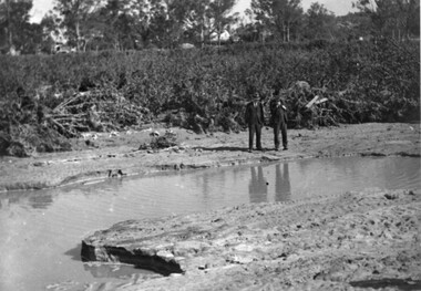
May 1900
This is a photograph of the original Orbost / Snowy River Bridge , a suspension bridge which opened in 1893. It has been taken when the Snowy River was in flood. It is similar to other photographs held in The State Library, Victoria. The Snowy River Mail and Tambo and Croajingolong Gazette Sat 12 Aug 1893 records the opening of this bridge as "the most important public event that has yet been commemorated in Eastern ......The Messrs McLeod, with whom the first settlement of this district is generally associated, took up their residence on the eastern bank of the Snowy River about the year 1841 or 42. The late Mr W. Roadknight and Mr T. T. Stirling took possession of the territory on the western side of the Snowy about 35 years ago. During the occupation of the country by cattle owners, very little progress was made in the way of roads and bridges, and except to the hardy and lexperienced bushman, it might have been generally regarded as inaccessible. About the year 1877, however, the late Mr James Robertson eldest son of Mr James Robertson, of Lochend farm, selected land now occupied by his father, about four miles from Orbost on the west bank of the river, Mr John Cameron visited the. district shortly after a .tour of inspection and returned later with his brothers, James and Alick Gameron, but found that during their absence Mr Ernest Watt had found his way on the scene and pegged out a selection, thus anticipating the advent of the Camerons by about 12 hours. We understand that a Mr Kidd, who selected the property now occupied by Mr W. J. Ross, at Pumpkin Point, was one of the earliest batch of settlors.........."This is a pictorial record of an early bridge across the Snowy River at Orbost.A black / white photograph of a suspension bridge with flood waters below the bridge.orbost-bridge suspension-bridge snowy-river -
 Orbost & District Historical Society
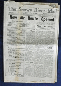
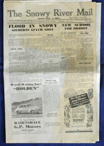
newspaper, Snowy River Mail, 29.3.1950
The Snowy River Mail is a weekly newspaper published in Orbost in the Shire of East Gippsland, Victoria, Australia. Previously published as The Snowy River mail and Tambo and Croajingolong gazette from 1890 to 1911. The Gippsland Courier merged with the Snowy River Mail when proprietor Lachlan Ross moved to Orbost in 1910. In 1999 the paper was acquired by the Yeates family when the Hollins family retired from the newspapers business. The paper is still being produced by the fourth generation of the Yeates family as part of East Gippsland Newspapers. The 1950 flood was a significant event in Orbost. This newspaper is a contemporary record of a significant local events.A Snowy River Mail newspaper dated 29.3.1950. It contains news articles and advertisements in black/white print. it contains an article on the flood at that time.snowy-river-mail 1950-flood newspaper -
 Orbost & District Historical Society
newspaper clippings, February 1971
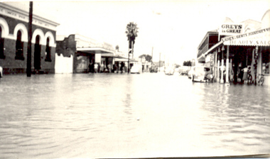
These articles were compiled by Mary Gilbert who was the first curator of the Orbost Museum and a prominent historian / teacher in Orbost. The 1971 floods at Orbost were the worst on record. At Jarrahmond the river rose to a height of 11 metres and on the flats spread to one and a half kilometres wide. Considerable damage was done to railway infrastructure, roads and farms. More information from the APRIL, 2008 newsletter by John Phillips. (see orbosthistory.com.au)These articles are contemporary records of a significant historical event in Orbost.A manila folder containing black / white newspaper clippings from various publishers. They all relate to the 1971 floods in Orbost. (Details of contents in catalogue 735-900)floods-orbost-1971 -
 Kew Historical Society Inc
Photograph - Burgess House, Victoria Street (Abbotsford), 1880-1900
Major floods recurred of the Yarra River on a regular basis. A flood in 1901 destroyed this house in Victoria Street, Abbotsford. Later print copy of an original photograph. Home of C/N Burgess on the south side of Yarra River. The buildings were washed away in a flood in 1901 The house was in the same location as that on which Handley & Tilly was later built. This would locate it on the north side of Victoria Street, Abbotsford between Burnley Street and the Victoria Street Bridge. Photo shows three men and one woman working in an established garden in front of a weatherboard cottage."Home of C/N Burgess on south side of river; washed away in 1901; Handley & Tilly on site"yarra river -- floods, yarra river flood -- 1901, burgess family -- victoria street -- abbotsford (vic.) -
 National Wool Museum
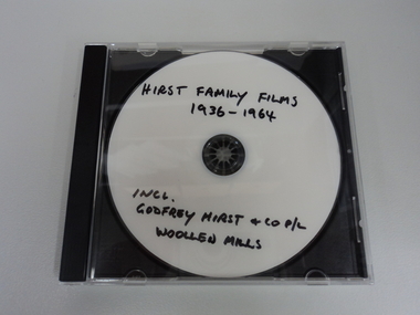
Film - Hirst Family Films, Cedric L Hirst, 1950s
Copy of Godfrey Hirst family videos/photograph on CD. Including 1951 floods at Mill. All video content filmed at Godfrey Hirst Woollen Mill, Swanston Street, South Geelong. Godfrey Hirst's children. Family home in Newtown and holiday home in Eastern View.Compact disc (CD) containing colour video footage. Film has no audio content. Visual content outlined below: 00:00 – 00:05 – External view of brick building – Godfrey Hirst & Co. Pty. Ltd. 00:05 – 00:10 – Exterior garden setting, three men in suits with fabrics and object 00:10 – 00:28 – Exterior garden setting showing eight women, most likely on a break from working at the Godfrey Hirst factory. The footage shows them all getting up and walking back towards the building at the end. 00:28 – 00:38 – Exterior garden setting, showing seven men in white shirts and ties seated and standing around a table, turning pages on a folder on the table. 00:38 – 00:52 – Interior factory setting, showing four men in coats handling green and red wool. 00:52 – 1:08 – Three men in suits in an exterior garden setting looking at paperwork. 1:08 – 1:23 – Four men in coats in a garden handling coloured wool samples. 1:23 – 1:42 – Four men in suits in a garden setting handling woven fabric. Two of the men are holding pipes. 1:42 – 1:57 – Interior factory setting showing men operating machinery. 1:57 – 2:05 – Exterior factory setting showing a man driving machinery carting wool bales. 2:05 – 3:14 - Flood scenes, showing the exterior of the Godfrey Hirst building with a man rowing a boat down the street, and a horse and cart in flood waters. There are scenes of flooded streets, exterior of flooded buildings and people standing in flood waters. 3:14 – 3:40 - Interior building views of flood waters in factory with people, machinery, equipment and textiles in flood waters. 3:40 – 4:03 - Exterior views showing a tractor, boat, horse and people in flood waters. 4:03 – 7:02 Exterior setting showing crowds of people watching a fashion parade. The fashion parade is of women in various clothing, including suits jackets, skirts, coats and hats. 7.02 - END"Hirst family films 1936-1964 Incl. Godfrey Hirst and co P/L Woollen mills"geelong, godfrey hirst & co. pty. ltd., family films, factory, flooding, 1950s, wool processing, fashion, textiles, horse and cart, wool bales, transport, machinery, fashion parade, working life -
 Orbost & District Historical Society
newspaper, 15.2.1950
The Snowy River Mail is a weekly newspaper published in Orbost in the Shire of East Gippsland, Victoria, Australia. Previously published as The Snowy River mail and Tambo and Croajingolong gazette from 1890 to 1911. The Gippsland Courier merged with the Snowy River Mail when proprietor Lachlan Ross moved to Orbost in 1910. In 1999 the paper was acquired by the Yeates family when the Hollins family retired from the newspapers business. The paper is still being produced by the fourth generation of the Yeates family as part of East Gippsland Newspapers. The flood in 1950 was a significant Orbost event. This newspaper is a contemporary record of a significant local events.A Snowy River Mail newspaper dated 15,.2.1950. It contains news articles and advertisements in black/white print. There is an artcle about the Orbost floods.newspaper snowy-river-mail flood-1950-orbost -
 Glenelg Shire Council Cultural Collection
Slide - Glass Slide - Horses in a flood, n.d
Glass slide - horses in a flood -
 Tatura Irrigation & Wartime Camps Museum
Photograph, Flood Streetscape
Hogan Street 1955 floodtatura, buildings, historic -
 Melton City Libraries
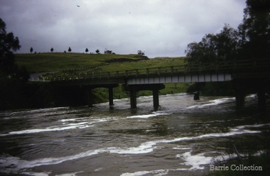
Photograph, Melton Weir, 1970
Spillway, bridge and river in flood.misc. -
 Melton City Libraries
Photograph, Flood at Toolern Creek, Unknown
Photos of a flood at Toolern Creeklandscapes of significance -
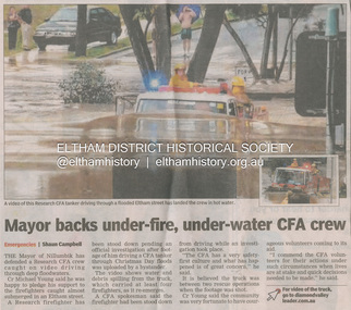 Eltham District Historical Society Inc
Newsclipping, Shaun Campbell, Mayor backs under-fire, under-water CFA crew, Diamond Valley Leader, December 2011
... floods ...A late afternoon storm on Christmas Day 2011. A flash flood occurred from significant rain fall and hail, which accumulated along an old waterway with floodwater submerging cars along Valonia Drive then down Grove Street flooding houses, through the Bible Street Reserve where it then submerged Main Road washing away the small railway trestle bridge opposite the reserve then flooding the Judge Book Village before finally entering the Diamond Creek. Widespread damage occured from hail and flash flooding.fay bridge collection, eltham, flood damage, floods, floodwater, main road, research fire brigade -
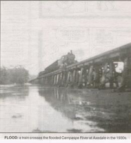 Bendigo Historical Society Inc.
Newspaper - JENNY FOLEY COLLECTION: FLOOD
Bendigo Advertiser "the way we were" from 1999. Flood: a train crosses the flooded Campaspe river at Axedale in the 1930s.newspaper, bendigo advertiser, the way we were -
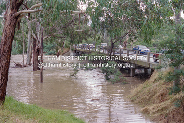
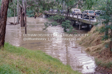 Eltham District Historical Society Inc
Negative - Photograph, Diamond Creek floodwaters near Main Road Bridge, Eltham, Feb. 2005
... floods ...Flooding of the Diamond Creek in February 2005Roll of 35mm colour negative film, 7 strips Associated colour print 10 x 15 cmKodak GC400-8bridge, diamond creek (creek), eltham, eltham south, floods, main road, main road bridge -
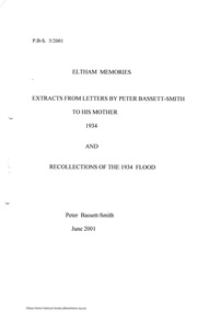 Eltham District Historical Society Inc
Folder, Eltham Memories, 2001
... Floods ...Written and transcribed by Peter Bassett-Smith. Extracts from letters to his mother 1934. Discusses his involement in a local play and other local observations in Eltham including recollections of the 1934 flood. 4 pagesHG Booklet 54harry gilham collection, peter bassett-smith, letters, floods -
 Eltham District Historical Society Inc
Photograph, Fay Bridge, Flood damage at Nillumbik Medical Centre, 1078 Main Road, Eltham, 26 December 2011
... floods ...Flood damage resulting from a late afternoon storm on Christmas Day 2011. A flash flood occurred from significant rain fall and hail, which accumulated along an old waterway with floodwater submerging cars along Valonia Drive then down Grove Street flooding houses, through the Bible Street Reserve where it then submerged Main Road washing away the small railway trestle bridge opposite the reserve then flooding the Judge Book Village before finally entering the Diamond Creek..fay bridge collection, 2011-12-26, bible street reserve, flood damage, floods, floodwater, main road, nillumbik medical centre -
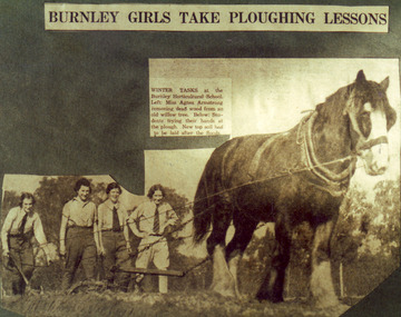 University of Melbourne, Burnley Campus Archives
Photograph - Colour print, The Sun, Burnley Girls Take Ploughing Lessons, 1935
Photograph made by A.P. Winzenried as a possible illustration for, "Green Grows Our Garden." There was a severe flood in December 1934.2 copies colour print.. Copy of a newspaper article made by A.P. Winzenried. Caption reads, "Burnley Girls Take Ploughing Lessons. Winter tasks at the Burnley Horticultural School. Students trying their hands at the plough. New top soil had to be laid after the floods." 4 female students working with a horse drawn plough in the Orchard.Handwritten underneath, "R.Weber, E. Pearce, M. Younger, W. Wittakers. "The Sun" 12-6-35."a.p. winzenried, green grows our garden, ploughing lesson, female students, r.weber, e. pearce, m. younger, w. wittakers, orchard, 1934 flood, horse, working outside -
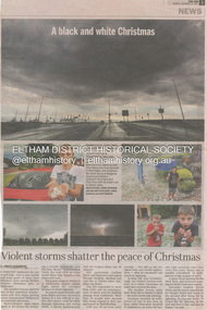 Eltham District Historical Society Inc
Newsclipping, Vince Chadwick, Violent storms shatter the peace of Christmas, The Age, Monday, December 26, p3, 2011
... floods ...A late afternoon storm on Christmas Day 2011. A flash flood occurred from significant rain fall and hail, which accumulated along an old waterway with floodwater submerging cars along Valonia Drive then down Grove Street flooding houses, through the Bible Street Reserve where it then submerged Main Road washing away the small railway trestle bridge opposite the reserve then flooding the Judge Book Village before finally entering the Diamond Creek. Widespread damage occured from hail and flash flooding.fay bridge collection, 2011-12-26, eltham, flood damage, floods, grove street, main road, valonia drive -
 Kew Historical Society Inc
Photograph, Chipperfield's Boat House & Floating Pontoon, 1934
Living with natural processes was frequently a challenge to early European settlers and later residents of what was in the 1850s administered by the Borondara Road Board. This was compounded by the area being bounded on three sides by rivers (Yarra River, Koonung Creek and Gardiner's Creek). In 1849, the historian James Bonwick recorded that "our district [Kew] suffered considerably. Mr Wade speaks of 80 acres, out of 100 acres of his cultivated paddock, covered by water." Newspapers continued to describe major flooding in Kew in 1863, 1869, 1878, 1880, 1889, 1891, 1916 and 1934. While the construction of the Upper Yarra dam in 1957 reduced the levels of flowing downstream, local and riverine floods continue. A number of boat houses operated on both sides of the River Yarra at Kew. Chipperfield's Boat House was located on the Yarra near the corner of Kilby and Willsmere Roads.The Kew Historical Society's pictures and map collections testify to the impact of flooding in the district. They have historical importance in documenting the extent of flooding in the district and its affects on homes, services and recreation. Numerous photographs record flooding throughout the Twentieth Century.Floating pontoon at Chipperfield's Boat House where the canoes were stored, taken in 1934, presumably before the 1934 Flood. This area of the Yarra was shallow with a number of mid river sandbanks and a popular swimming area for locals.yarra river, chipperfield's boathouse, pontoon -
Glenelg Shire Council Cultural Collection
Slide - Glass Slide - Glenelg River, n.d
Glass slide - Glenelg River in floodslide, photography, glenelg river -
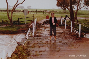 Melton City Libraries
Photograph, Wendy Barrie on the Darlingsford Bridge, 1983
Property of Lot 1 Thomas Bell Darling 1853 1863 Ralph Parkinson 1887 Sold to Richard Manning (Cr and Hotelier) leased by John Walsh Minns family lived at the house in the time of Welsh. C Parkinson died in Jan 1887 Ralph Parkinson was a prominent citizen of Melton and was known for his generosity, and his involvement in the community and the Church of England. He had one daughter, his wife and other daughter died earlier. He died in Jan 1887Photo was taken during the October floodslocal identities, landscapes of significance -
Clunes Museum
Ephemera - DVD, CLUNES FLOOD 2010, 2010
CD WITH PHOTOGRAPHS OF THE 2010 FLOODS IN CLUNESclunes floods 2010, floods 04/09/2010