Showing 4562 items
matching fraser
-
 Lakes Entrance Historical Society
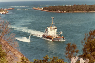
Photograph - April Hamer, Fraser, Ian, 1980 c
Colour photograph of side casting sand dredge, April Hamer, working in the channel below Kalimna Hill inside the entrance from Bass Strait. Ocean in background, rock groynes of the entrance visible. Lakes Entrance Victoria waterways, dredging -
 Lakes Entrance Historical Society
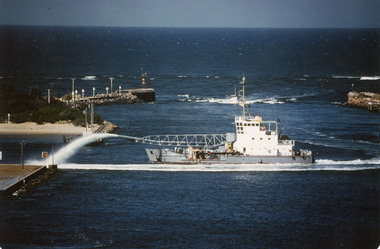
Photograph - April Hamer, Fraser, Ian, 1980 c
Colour photograph of the sand dredge, April Hamer, working inside the entrance off Bullock Island. Ocean in background, rock groynes of the entrance visible, a fishing boat coming through the entrance. Lakes Entrance Victoriawaterways, dredging -
 Lakes Entrance Historical Society
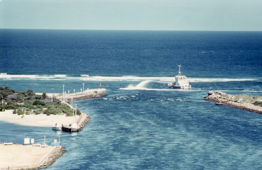
Photograph - April Hamer, Fraser, Ian, 1980 c
Colour photograph of the side casting dredge, April Hamer, working at the entrance. Ocean in background, entrance to Gippsland Lakes. Photo shows rock groynes at entrance. Lakes Entrance Victoriajetties, waterways, ships and shipping -
 Lakes Entrance Historical Society
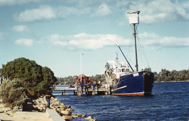
Photograph - Dageraad, Fraser, Ian, 1980c
Colour photograph of Mitchelsons fishing boat Dageraad at Bullock Island jetty, Lakes Entrance, Victoriafishing industry, boats and boating -
 Lakes Entrance Historical Society
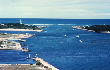
Photograph - The Entrance, Fraser Ian, 1995c
Colour photograph of the entrance from Bass Strait to the Gippsland Lakes. It shows the western end of Bullock Island and the entrance to North Arm, cars parked on island and many people fishing. This area built up during dredging operations over many years. Lakes Entrance Victoria topography, fishing industry, boats and boating -
 Lakes Entrance Historical Society
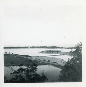
Photograph - Bullock Island, Fraser Ian, 1920c
Black and white photograph of Bullock Island, showing Prince's Highway from North Arm bridge, east end of Bullock Island and bridge, entrance to Bass Strait and sand dunes along Cunninghame Arm. Western end of Bullock Island bridge raised to allow small boats access to North Arm and Cunninghame Arm, became known as Humpy Bridge. Lakes Entrance Victoria islands, waterways, topography, bridges -
 Lakes Entrance Historical Society
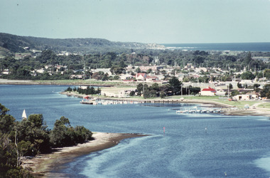
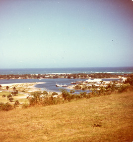
Photograph - Lakes Entrance, Fraser, Ian, 1985c
Colour photograph of the township, situated between Cunninghame Arm and North Arm. Boats moored in North Arm. Scrub covered hummocks of southern shore in background, taken from cleared vantage point on Kalimna Heights. Lakes Entrance Victoria boats and boating, waterways, township -
 Lakes Entrance Historical Society
Photograph - Lakes Entrance, Fraser, Nancy, 1985c
Colour photograph of a bend in the North Arm. It shows the sports ground, eastern end of town. Jetties and hire boats at edge of lake. Photo taken from cleared hill, Kalimna, in foreground. Bass Strait in distance. Lakes Entrance Victoriawaterways, township -
 Lakes Entrance Historical Society
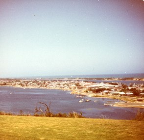
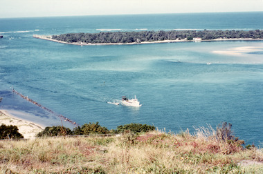
Photograph - The Entrance, Fraser, Ian, 1990c
Colour photograph of the lake. It shows a fishing boat with scallop dredge moving up the lake opposite the artificial entrance, grassy edge of Jemmy's Point in foreground above highway guard fence, rock groyne at entry to North Arm, sandy shallows at entry to Hopetoun Channel, scrub covered hummocks of south shore and Bass Strait in distance. Lakes Entrance Victoriaislands, waterways, topography -
 Lakes Entrance Historical Society
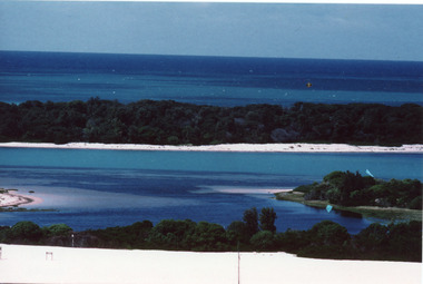
Photograph - Hopetoun Channel, Fraser, Ian, 1996c
Colour photograph of Bass Strait, scrub covered coastal dunes, Hopetoun Channel, and southern portion of Rigby Island. Photo taken from sand dunes on Flannagan Island, near Lakes Entrance, Victoria.islands, waterways, topography -
 Linton and District Historical Society Inc
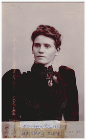
Photograph, Fraser, 30 Bridge St., Ballarat, Kate Pearson of Happy Valley
This photo was lent to LDHS in 1983 by Mrs. E. Monti of Shepparton (a descendant of one of the Davies families of Happy Valley), so that a copy - Mounted photo 113 - could be made. It was donated to the Society in 2016 by Mrs. Monti's daughter Joan. See "Davies - James & Agnes" file. Date of photograph 1890-1900 is identified in inscription on the back of the photo. This date is highly probable, as "leg of mutton" sleeves were fashionable at this time.Sepia photograph mounted on card of a young woman wearing a dress with a high, beaded collar, ruching on the bodice, and "leg of mutton" sleeves. A large brooch of artificial leaves and berries is worn on the bodice near the collar. "BEATRICE WARD OF HAPPY VALLEY" is written on the card underneath the photograph. This has had a label reading "KATE PEARSON OF HAPPY VALLEY" taped over it.On back: "Given to Sarah Davies / KATE PEARSON OF HAPPY VALLEY / Don't know what year taken possibly 1890-1900." "RETURN TO / MRS E. MONTI / 56-58 REA ST SHEPPARTON".kate pearson -
 Linton Mechanics Institute and Free Library Collection
Book - Novel, Fraser, Jane, A family affair, 1958
Romance fiction.187 p. : brown cover, embossed in black. Section of original dust jacket pasted to front, and summary of plot, also cut from dust jacket, pasted inside front cover. Image of a young man and a young woman with ski equipment, against a background of snowy hills.Romance fiction.fiction, romance, jane fraser -
 Eltham District Historical Society Inc
Document - Series Listing, Fraser Faithfull et al, Series 04: Objects, 2000
This Series consists of memorabilia items such as plaques, medals, badges, certificates, a seal stamper, wine glasses, flagpoles, a ballot box etc.shire of eltham archives, series listing -
 Victorian Railway History Library
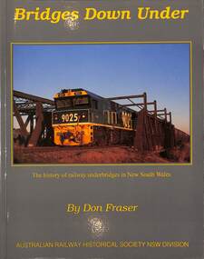
Book, Fraser, Don, Bridges Down Under: The history of Railway underbridges in New South Wales, 2016
A history of railway underbridges (structures that support a railway line) in New South Walesindex, ill, maps, p.202.A history of railway underbridges (structures that support a railway line) in New South Walesrailway construction - new south wales - history, bridges -- new south wales -- design and construction -
 Linton and District Historical Society Inc
Photograph, Fraser, 30 Bridge St, Ballarat, The Cornish Family, circa 1890
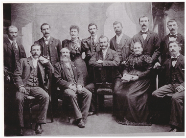
Photograph of the Cornish family, back row L-R Dick, Bob, Fanny, Dan, Tom, Jack Ben. front Harry, Richard (dad), Fred, Maria (mum), Sam.Large original sepia photograph of Cornish family, 4 men 1 woman holding book, seated. 6 men 1 woman with flowers, standing.On back: "Cornish family"cornish family -
 Lakes Entrance Historical Society
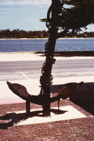
Photograph, Fraser, Ian, 1990c
Colour photograph of the anchor situated at the Central Shopping Plaza. It shows an anchor of unknown origin, highway, Cunninghame Arm, scrub covered sand hummocks of South shore. Lakes Entrance Victoria township, waterfront, topography -
 Clunes Museum
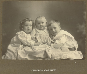
Photograph, FRASER STUDIO, LAZARUS CHILDREN
BLACK AND WHITE PHOTOGRAPH OF LAZARUS CHILDREN - NAOMI, HARRY AND MARK .LEFT TO RIGHT- NAOMI, HARRY AND MARK LAZARUS, CLUNES CELORON CABINETlocal history, photography, photographs, crick, shrigley, mc lennan, lazarus -
 Lakes Entrance Historical Society
Photograph - Cunninghame Arm, Fraser, Nancy, 1970c
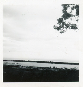
Black and white photograph of a distant view township and Cunninghame Arm and scrub covered hummocks of southern shore in distance. Lakes Entrance Victoria topography, waterways -
 Lakes Entrance Historical Society
Photograph - Bullock Island, Fraser Ian, 1975c
Color photograph of the eastern part of Bullock Island, showing buildings of Lakes Entrance Fishing Co-Operative and PWD, spit opposite Club Hotel has been sown with grass, hummocks and Bass Strait in distance. Taken from Seaview Parade Kalimna. Lakes Entrance Victoriawaterways, islands, land reclamation, topography -
 Melbourne Tram Museum
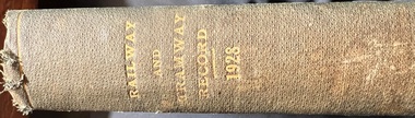
Book - Bound copies, Australian Electric Traction Association (AETA), "The Tramway Record", 1928
Bound set of the Australian Tramway Employees Association "The Tramway Record" Vol 33 No. 1 to No. 13 for 1928. Details the issues of the day, union matters, has many advertisements for both Sydney and Melbourne, personnel issues, and reports from the depots.Yields information about the activities of the AETA in 1928Book-bound journals - heavy green covers, with gold block title on spine."Railway & Tramway Record 1928"tramways, trams, unions, aeta, tramway record -
 Melbourne Tram Museum
Book - Bound copies, Australian Electric Traction Association (AETA), "The Tramway Record", 1931
Bound set of the Australian Tramway Employees Association "The Tramway Record" Vol 36 No. 1 to No. 13 for 1931. Details the issues of the day, union matters, has many advertisements for both Sydney and Melbourne, personnel issues, and reports from the depots.Yields information about the activities of the AETA in 1931Book-bound journals - heavy green covers.tramways, trams, unions, aeta, tramway record -
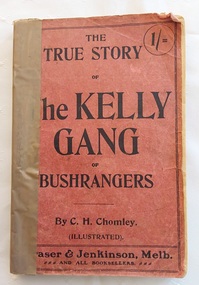 Mont De Lancey
Book, C.H. Chomley, The True Story of the Kelly Gang of Bushrangers, 1920's
"The True Story of the Kelly Gang of Bushrangers, published in 1900, was a highly researched biography of the notorious 19th-century Victorian family of bushrangers. Chomley wrote the biography using court documents, police records and court evidence.] It is recognised as being one of the most accurate depictions of the story of Ned Kelly, particularly regarding the police involvement. In his discussion of The True Story of the Kelly Gang of Bushrangers, Paul Eggert writes: "He often expresses scepticism about the extant accounts of events and of motives, but his attitude is always one of confident understanding and conservative judgement". As the nephew of Arthur Wolfe Chomley, the Assistant prosecutor at Ned Kelly’s trial in 1880, and the nephew of Hussey Malone Chomley, a police officer during the Kelly years, Chomley had a unique insight into the case."--Back cover.A small faded red book titled: The True Story of the Kelly gang of Bushrangers by C.H. Chomley with publisher details at the bottom. 1/= price is listed at the top right hand corner of the front cover. The spine is bound on the left side with brown tape as the title page and last few back pages and cover are missing. Inside the front cover are two advertisements for books which may interest the reader.The frontispiece black and white illustration is of the five Kelly Gang members: Dan Kelly, Steve Hart, Joe Byrne, Aaron Sherritt and Ned Kelly.There is a Contents page with a Note on the reverse stating the writers carefully consulted official documents, newspapers and other sources of information. There are other full page illustrations. Pp.156 (some missing at the end).non-fiction"The True Story of the Kelly Gang of Bushrangers, published in 1900, was a highly researched biography of the notorious 19th-century Victorian family of bushrangers. Chomley wrote the biography using court documents, police records and court evidence.] It is recognised as being one of the most accurate depictions of the story of Ned Kelly, particularly regarding the police involvement. In his discussion of The True Story of the Kelly Gang of Bushrangers, Paul Eggert writes: "He often expresses scepticism about the extant accounts of events and of motives, but his attitude is always one of confident understanding and conservative judgement". As the nephew of Arthur Wolfe Chomley, the Assistant prosecutor at Ned Kelly’s trial in 1880, and the nephew of Hussey Malone Chomley, a police officer during the Kelly years, Chomley had a unique insight into the case."--Back cover.australian history, bushrangers, history victoria, history books, history ned kelly -
 Lakes Entrance Historical Society
Photograph - St Andrews Presbyterian Church Bairnsdale Victoria, Ian Fraser, 1980 c
Sold for business use after amalgamation of Presbyterian and Methodist cjurches to become Uniting ChurchColour photograph of St Andrews Presbyterian Church Main Street Bairnsdale Victoriahistoric buildings, religion, churches -
 Eltham District Historical Society Inc
Document - Series Listing, Fraser Faithfull et al, Series 74: Shire of Eltham - Newsclippings Folders, 2000
This Series consists of a set of three folders of historical newsclippings relating to the Shire. The first volume (Item I) spans Sept 1959 - Aug 1969 The second volume (Item 2) spans August 1969- Dec 1972 The third volume (Item 3) spans Jan 1971 - Dec 1973 Preservation copies have been made on archival paper. Reference copies have been made from the preservation copies. The reference copies have been placed in five ring binder folders: the first volume in Reference Folder I, the second volume in Reference Folder 2 and the third volume in Reference Folders 3 - 5.shire of eltham archives, series listing -
Clunes Museum
Photograph - LITHOGRAPH PRINT
THIS PHOTOGRAPH WOULD HAVE BEEN TAKEN PRIOR TO THE FIRESWHICH DESTROYED THE ORIGINAL SHOPS IN FRASER STREETLITHOGRAPH OF A SCETCH OF PORT PHILIP MINING COMPANYAND THE TOWNSHIP OF CLUNES WITH FRASER STREET IN THE FRONT ORIGINAL PHOTOGRAPH TAKEN FROM THE HILL BEHIND THE OLD LIBRARY IN TEMPLETON STREET TOWNSHIP OF CLUNES 1869 HANDSIGNED BY GEOFFREY BLAINEY - 17/3/2001clunes 1869 port philipmine, geoffrey blainey, lithograph of mine -
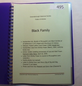 Greensborough Historical Society
Folder, Black Family, 1900o
Contents: Handwritten list of burials of McLaughlin and Black families at St Katherine's St Helena; handwritten family tree by Shirley Fraser; letter re McLaughlins Lane; un-named family photos; television fan memorabilia from 1950s.History of the origins of this Greensborough family. Includes McLaughlin, Fraser, Black.20-page plastic binder, spiral bound, purple cover. Contains documents relating to the Black and Fraser family.Collected by Greensborough Historical Society. Folder commenced 2012.black family, shirley fraser, mclaughlin family, watsonia -
Clunes Museum
Photograph
COMMEMORATION OF THE CLUNES RST WITH A MOSIAC INSTALLED ONTO THE FRONT OF THE BUILDING FACING FRASER STREET.1 BLACK AND WHITE PHOTOGRAPH RSL CLUNES AT THE UNVEILING OF COMMEMORATION OF THE RSTL BUILDING ON 25TH APRIL 1962, 4 MEN STANDING AT THE ENTRANCE, CROWD IN FRASER STREET WITNESSING THE EVENT. .2 STAMP ON BACK: COPYRIGHT - NOT FOR REPRODUCTIONS - HERALD SUN PHOTOGRAPH SUPPLED BY FEATURE SERVICE, THE HERALD AND WEEKLY TIMES LTD, MELBOURNE - AUSTRALIArsl clunes, rsl artwork -
Lakes Entrance Historical Society
Photograph - Healy/Fraser, 1990 c
Also a second photograph showing Peter Healy planting Nan Frasers new garden with Pope the dog helping at Rowe Street 05333.1 10 x 15 cmColour photograph showing Gwen Healy cutting cake and Nan Fraser seated both residents of units in Rowe Street Lakes Entrance people -
 Warrnambool and District Historical Society Inc.
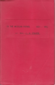
Booklet, On the Western Patrol, Mid 20th century
This is the story told by the Rev. C. Fraser of his two years as a Home Missionary of the Presbyterian Church in the Otway Ranges in 1891-2. The area covered was from Lorne to Peterborough. The booklet includes the names and activities of many settlers of the time and a description of the wreck of the Newfield. This book is of interest to researchers looking for information on the Otway Ranges settlers at the end of the 19th century. It includes names and events and gives an interesting insight into life in the Otway Ranges in the 1890s. This is a small booklet of 44 pages with a red cover and the title printed in black on the front cover. The pages have been stapled together. There are no photographs or illustrations. Front Cover: ‘On the Western Patrol 1891-1892 by Rev. C.A. Fraser’presbyterian church, home missions otway ranges, warrnambool, rev. c. fraser -
 Ballan Shire Historical Society
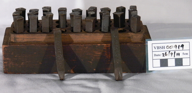
Tool - Metal hand stamping tools
This box of metal stamps was owned by Mr D.K. Fraser, a property owner and grazier in the Ballan district.A timber box, split horizontally, with 27 (3x9) holes drilled vertically containing square section metal hand stamping tools each a separate letter of the alphabet.The top lid is marked "D K F & CO 1905" and each stamp is marked "D K FRASER".tools, ballan, fraser dk, metal stamps