Showing 984 items matching " jetties"
-
 Lakes Entrance Historical Society
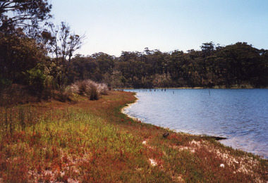
Photograph - Lakes Tyers Landing, 1999 c
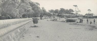
Site was important during tourism era of the 1880's to 1940's, when coachloads of passengers transferred to trips around Lake Tyers and up to Nowa Nowa. Also known as Bulmer's Landing.A colour photograph of the former tourist landing on Lake Tyers, showing remnant piles of a jetty, calm waters of lake and a high tree covered bank opposed the low jetty shore. Lake Tyers Beachtopography, waterways, landing -
 Flagstaff Hill Maritime Museum and Village
Photograph - Coastal Scene, 1930-1932
The black and white photograph is a typical beach scene taken at Lady Bay, Warrnambool, between 1930 and 1932. In the background is the coastal trader, the steamship SS Casino. Adults and children are in the foreground, playing on the beach and in the water. The old jetty is on the left and the Warrnambool Breakwater is on the horizon. The S.S. Casino was a passenger and freight steamer built in Dundee, Scotland, in 1882 for the Newcastle and Hunter River Steam Navigation Company of N.S.W. The vessel weighed 425 tons gross with a length of 160.4 feet, a beam of 24.1 feet and a depth of 10.2 feet. Accommodation for 35 people was provided in the saloon, and 25 passengers in the fore-cabin, plus room for 300 tons of cargo. On May 30th 1882 the S.S. Casino called in at the Port of Warrnambool for coal, narrowly escaping being swept ashore in gale-force winds due to the pilot's quick action. At that time, still at anchor, the directors of the Belfast and Koroit Steam Navigation Company were so impressed that they bought the S S Casino immediately; being ideally suited for trade along the West Coast of Victoria; Belfast is the original name for Port Fairy, South West Victoria. The Belfast and Koroit Steam Navigation Company was first managed by Messers Saltau and Osburne, and after the passing of Mr Osburne, by produce merchants Messers H. Sautau and Sons, owners of a hay and corn store and shipping agency was on the corner of Liebig and Koroit Streets in Warrnambool. The S.S. Casino was named “the most famous steamer to operate in Victorian waters along the West Coast” by maritime author Jack Loney. Captain Boyd was her first Master, followed by Captain Chapman, who stayed with her from 1890 until 1924. Captain W. Robertson followed for a short term, and then Captain Middleton took command from 1925 to 1932. The S.S. Casino had several mishaps during her life. One was on 3rd January 1898 when the ship collided with the S.S. Flinders in Apollo Bay with minor damage. Another was on 24th October 1924 when the Casino was grounded on a reef at Point Hawdon near Grey River and most of her cargo of Christmas goods had to be dumped into the sea. Then in February 1929, the Casino was ‘holed’ when it struck a submerged object as it entered Lady Bay, Warrnambool. On the morning of 10th July 1932, after attempting to berth at Apollo Bay jetty in heavy seas, Captain Middleton decided to take S S Casino out into the bay and wait until the seas abated. It was not realised that the anchor that steadied the ship during a manoeuver had pierced its hull, and it sank as it headed for the beach. Captain Middleton and nine others lost their lives, but nine people were rescued including the two female passengers. Captain Middleton had been in charge of the S.S. Casino for seven years. He was the first ship’s Master to lose his life in a shipwreck in the West Coast trade. In the years following the turn of the century, the S.S. Casino remained the only regular trader with normal passenger accommodation along the West Coast. From 1882 it had made at least 2,500 voyages on the one run. Flagstaff Hill’s collection has a portrait photograph of Captain Chapman, a ship model of the S.S. Casino that shows both forms of power under which it sailed, steam and sail. The ship is painted green and flies three flags. The inscription across the case of the ship model, incorrectly dated, tells the sad story of the wreck of the ship and the loss of lives on July 10th 1932 at Apollo Bay. A print in the Collection shows S.S. Casino underway in the heavy sea off Point Lonsdale, another two photographs show it at the Port of Warrnambool, leaving from the Breakwater in Lady Bay, and another identifies the S.S. Casino as a ship from the Belfast and Koroit Steam Navigation Company.The photograph shows an example of the Warrnambool community and family bathing and beach activities of the 1930s. It also shows a point in time when the jetty and the Breakwater were in the Bay. The photograph is significant because of its association with the coastal trader S.S. Casino 1882-1932 and its significance to cargo and passenger trade along Victoria's West Coast in the late 19th and early 20th centuries. The wreck of the S.S. Casino is considered an important part of Victorian and Australian cultural heritage and as such has been declared and protected as a Historic Shipwreck under State and Commonwealth Law in the Commonwealth Historic Shipwrecks Act (1976).Black and white photograph of steamship S.S Casino leaving Warrnambool. Taken from the beach, adults and children on shore and in the water. There is a jetty on the left and and the Breakwater on the right. Circa 1930-1932.newcastle and hunter river steam navigation company, belfast and koroit steam navigation company, h. sautau and sons, s.s. casino, west coast trader s.s. casino, victorian coastal trader, captain boyd, captain w. robertson, captain chapman, captain middleton, apollo bay shipwreck, lady bay warrnambool, saltau and osburne, port of warrnambool, warrnambool breakwater, beach, bathing, 1039, 1931, 1932, beach scene, swim, warrnambool jetty -
 Phillip Island and District Historical Society Inc.
Photograph, 1940's 1950's
Photograph donated by John JanssonBlack & White aerial view of the Cowes Township and jetty area, Phillip Islandcowes phillip island, aerial view of cowes, cowes jetty, cowes pier phillip island, john jansson -
 Phillip Island and District Historical Society Inc.
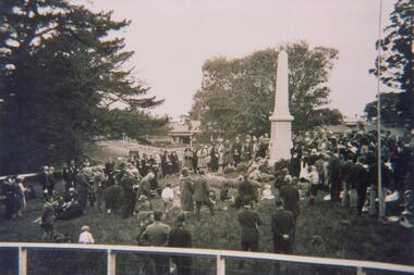
Photograph, Photograph of Cowes cenotaph and crowd, Post W.W.I
One of a collection of photographs donated by Bruce BennettBlack & White photograph of a gathering of people around the Cenotaph at the Jetty Triangle, Cowes.On back: Mary Karney collectioncowes cenotaph, phillip island, cenotaph cowes phillip island, war memorial cowes phillip island, bruce bennett -
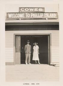 Phillip Island and District Historical Society Inc.
Photograph, Cowes Jetty Shed, Feb 1939
One of a collection of 18 photographs & postcards donated by Jill YeomanBlack & White photograph of the Cowes Jetty Shed with a male & female standing in the entrance.Cowes Feb 1939cowes jetty shed, jetty shed cowes phillip island, jill yeoman -
 Queenscliffe Maritime Museum
Photograph, Photographer unknown
A colour photo of life at Queenscliffe for local fishermen, sailors and crew.Realism, historicalA photograph of a painting, by R Wilson [1861], of boats at the Point Lonsdale pier and jetty.On the reverse - "NIL."wharf, sailing boat, pier, boats -
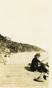 Lakes Entrance Historical Society
Photograph - Steve Tunks Fishing, 1930 c
Black and white photograph of Steve Tunks fishing off jetty at Kalimna Victoriagenealogy, recreation -
 Lakes Entrance Historical Society
Photograph - Carpentertown, 1920c
... Jetties ...Copied from copy in J Whadcoat collectionBlack and white photograph showing P W D cottage on left and other Works buildings on dune at the entrance to Gippsland Lakes from the ocean - Bass Strait. View shows flagstaff on top of dune and flagstaff jetty in lake - Cunninghame Arm. Small sailing boat on left and other small craft on shoreline. Section of Bullock Island with vegetation, one telegraph pole and one dead tree on island. Shoreline of North arm in foreground. Lakes Entrance Victoriajetties, waterways, settlement, historic site, boats and boating -
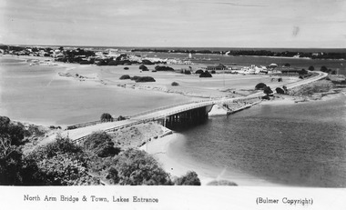 Lakes Entrance Historical Society
Postcard - Lakes Entrance from Jemmys Point, Bulmer H D, 1950c
... Jetties ...Township of Lakes Entrance from Jemmys PointColour tinted postcard of township showing bridge across North Arm; town buildings including Club Hotel, Methodist Church, Maranui Guest House; tower of Central Hotel; jetties in Cunninghame Arm, and sand dunes. Caravan parked beside concrete brick constructed toilet block opposite road to Bullock Island. Footbridge across Cunninghame Arm in distance, also lookout tower on Esplanade, and Life Saving tower over hummocks. Lakes Entrance VictoriaNorth Arm Bridge and Town, Lakes Entrancetownship, jetties, guesthouses, islands, hotels -
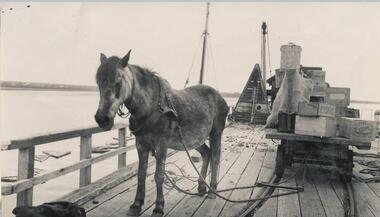 Phillip Island and District Historical Society Inc.
Photograph
One of a collection of over 400 photographs in an album commenced in 1960 and presented to the Phillip Island & Westernport Historical Society by the Shire of Phillip IslandPhotograph of "Sal" the Pier Pony on the Cowes Jetty. Trolley loaded with cargo. Sal had no bridle, no reins and no whip as she knew all there was for a pony to know about the jetty and trolley she pulled along it for fifteen years.local history, photography, photographs, "sal" the pier pony, transport, ponies, cowes jetty, john jenner, bryant west -
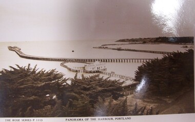 Glenelg Shire Council Cultural Collection
Postcard - Postcard - Panorama of Portland Harbour, n.d
Black and white photographic image of a harbour with two long piers running into it and a shorter jetty with a building on it and circular jetty protruding from it. In the foreground are trees, a dirt road to the foreground right and a railway track visible between the trees.Front: THE ROSE SERIES P. 1113/ COPYRIGHT (typed, lower left) PANORAMA OF THE HARBOUR, PORTLAND (typed, lower centre) Back: (no incriptions) -
Port Melbourne Historical & Preservation Society
Photograph - Sandridge Lagoon, Latrobe Library, 1920s
Photograph is a copy of one held in the PP Port Melbourne photo collection. It was donated and presented to the PMH&P Society by Joan WINTER of the City of Port Phillip at the August 1996 Annual General Meeting photograph of Sandridge Lagoon, viewed towards Bay: Western Jetty shown with several fishing vessels alongside. People on the Jetty (some with pushbikes); edge of Harper's building at right. (Laser copy also at A.06.04.B1 - 475.02) sandridge lagoon, industry - fishing, sport - yachting -
Phillip Island and District Historical Society Inc.
Photograph, circa 1900
From left of picture showing the San Remo and Piers Hotels. A horse hitched to part fence on side of road. Bushes between hotels and foreshore. The Genesta, Jetty, Coal Jetty and Jetty leading to what could be baths jutting out into Westernport. Phillip Island foreshore in background.Sea shore looking across to Phillip Island. Large photograph extensive white - grey sky. Road and hotels in front of beach.local history, photography, photographs, slides, film, sea shore san remo, hotels, black & white photograph, miss elms san remo -
 Flagstaff Hill Maritime Museum and Village
Document - Navigation Chart, Admiralty Office, Lady Bay and Warrnambool Harbour, 1893
This navigation cart of Lady Bay and Warrnambool Harbour was originally surveyed in 1870 but this version includes the update for magnetic variation in 1893. Since the printing of the chart several annotations have been added. These include an additional stamp dated 15-8-1910, a handwritten comment across the top of the page dated August 1910, and another handwritten comment regarding the ‘Proposed Extension of Dock’ dated 19-2-1925, plus connected drawings, notes and figures. The 1925 proposal on this chart may have been a reaction to the Royal Commission of 1923, when the damaged stonework on the seaward side of the Warrnambool Breakwater, caused by the action of the sea, was the subject of enquiry. A conference between the Public Works, Water Commission and the Harbour Trust concluded that it would less costly to make repairs to prevent further damage rather than replaced the damage portion of the wall. A contract was raised in late 1924 to deposit rubble on the damaged side of the breakwater to minimise the Southern Ocean’s destructive action and work had started by August 1925. The Breakwater construction had begun in 1874 and was completed in 1890. The Victorian Government had commissioned Sir John Coode, a British harbour engineer, to present a plan to complete the Warrnambool Breakwater but his original plan was too expensive. He prepared a revised plan for a shorter structure. The construction proved to be too short to protect adequately from the weather and didn't allow enough depth for larger vessels to come into port. The decreasing trade was further affected by siltation in the bay due to the breakwater, and the completion of the railway line. The situation of the harbour became a real problem by 1910 and required continuous dredging. In 1914 the Breakwater was extended but proved to be a failure because the work began to subside and by 1920 about two thirds of the harbour was silted up. Alterations made in the 1920's increased the silting problem and by the 1940's the harbour was no longer used. More alterations were made in the 1950's and 1960's. This chart is significant for its strong connection to the maritime history of Warrnambool Harbour and Lady Bay and the Warrnambool Breakwater. The Warrnambool Breakwater is registered as a place of significance on the Victorian Heritage Database (VHR H2024). The Warrnambool Breakwater is one of the most important late 19th century maritime engineering projects in Victoria and significant in the development of Victorian coastal shipping. It is also significant for its connection with British harbour engineer, Sir John Coode. The chart is a historical record of structures existing in 1893; the Warrnambool Jetties, Warrnambool Breakwater in Lady Bay, the leading lights (lighthouses), streets, roads, bridges and many buildings. It also shows the lay of the land and seabed. Navigation Chart: Lady Bay and Warrnambool Harbour, Australia - South Coast - Victoria. Surveyed by Nav. Lieut. H.J. Stanley, R.N., 1870. Updated for Magnetic Variation, 1893. The rectangular chart is printed on heavy cream paper. Stamps are shaped rectangular, oval and round. Around the Breakwater and Jetty area are handwritten notes, dotted and joined lines, numbers and signatures, and shading of red and green. The chart shows the surrounds of Warrnambool Harbour, Lady Bay, the Breakwater and Jetty, roads, bridges and the streets in Warrnambool. It has sounding details, and angles of line from the leading lights.Stamp, rectangular, including "AUG 1910" Stamp, double oval " - - - -CHART" Stamp, hand drawn, red circle, with "B" inside Hand written note "22-8-1910 - - - - - of surveying C. Ca - - - request of 15-8-10 [initials] " Notes and lines in red pen, including a grid of sounding numbers: "1300" "1050" "1200" "Possible Extension of Dock" "19-2-25" "Dock Dredged to 20 Ft" Notes and lines in blue pen "Extension of Dock to accommodate vessels drawing 20 Feet" and "Light not visible south of this line" Red dots (4) with yellow highlight at both leading lights, breakwater and jettyflagstaff hill, warrnambool, flagstaff hill maritime museum & village, maritime museum, maritime village, shipwreck coast, map, chart, navigation chart, plan, lady bay, warrnambool harbour, port of warrnambool, breakwater, jetty, pier, dock extension, proposed extension, vhr h2024, 1870, 1893, 1910, 1925, warrnambool town late 1800s, warrnambool streets late 1800s royal commission, 1923, public works, water commission, harbour trust, victorian harbours, sir jon coode -
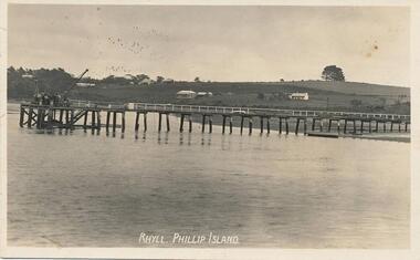 Phillip Island and District Historical Society Inc.
Photograph - Post Card, Kodak
Donated by S Serpell of Serpell & Reid families, Sandringham.Black & White postcard of the Rhyll Jetty with houses in the background. Some people at the end of the pier.Rhyll, Phillip islandrhyll jetty, rhyll phillip island, s serpell -
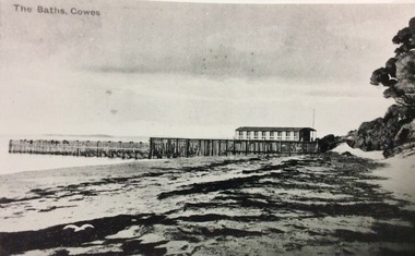 Phillip Island and District Historical Society Inc.
Photograph, Swimming Baths, Cowes
Part of a collection of Rose & Valentine Postcards. Copied by John Jansson 1984Black & White Postcard. View of Swimming Baths, Cowes. showing old Jetty shed.The Baths - Coweslocal history, photography, photographs, postcards, view cowes, phillip island, black & white postcard, copy., cowes baths, jetty shed -
 Phillip Island and District Historical Society Inc.
Photograph
One of a collection of over 400 photographs in an album commenced in 1960 and presented to the Phillip Island & Westernport Historical Society by the Shire of Phillip IslandPhotograph of the Steam Ship "Whyralla" at Rhyll Jetty loading logs from Churchill Islandlocal history, photography, photographs, maritime technology, cargo handling, ss "whyralla", black & white photograph, shipping, ss whyralla, rhyll jetty, loading, loading logs from churchill island, john jenner, bryant west -
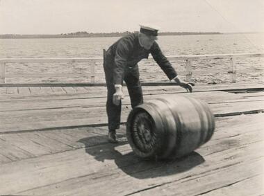 Phillip Island and District Historical Society Inc.
Photograph
One of a collection of over 400 photographs in an album commenced in 1960 and presented to the Phillip Island & Westernport Historical Society by the Shire of Phillip IslandPhotograph of Captain James Clark rolling a barrel on Cowes Jetty. Sandy Point in background.local history, photography, photographs, captain james clark, ferry captain, black & white photograph, shipping, ferry captains, cargo, cowes jetty, john jenner, bryant west -
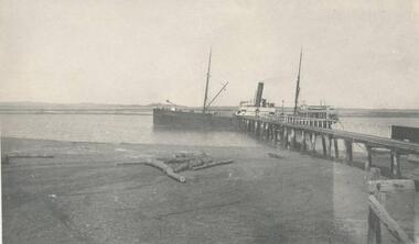
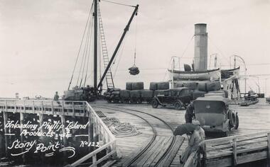 Phillip Island and District Historical Society Inc.
Photograph
One of a collection of over 400 photographs in an album commenced in 1960 and presented to the Phillip Island & Westernport Historical Society by the Shire of Phillip IslandPhotograph looking down the Stony Point Jetty with the S.S."Killara" being unloaded by Derrick.local history, photography, photographs, maritime technology, cargo handling, stony point jetty with s, "killara" background, shipping, steam ships, ss killara, stony point, phillip island produce, john jenner, bryant west -
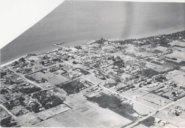 Phillip Island and District Historical Society Inc.
Photograph, Bryant West
One of a collection of over 400 photographs in an album commenced in 1960 and presented to the Phillip Island & Westernport Historical Society by the Shire of Phillip Island.Aerial photograph - panoramic view of Cowes looking north-east with Jetty and Foreshore in backgroundlocal history, photography, photographs, cowes foreshore, jetty, cowes, beaches, aerial view of cowes, aerial view of cowes phillip island, john jenner, bryant west -
 Phillip Island and District Historical Society Inc.
Photograph
One of a collection of over 400 photographs in an album commenced in 1960 and presented to the Phillip Island & Westernport Historical Society by the Shire of Phillip IslandPhotograph of the ferry, "Genista" from a point astern and steaming west towards Cowes Jettylocal history, photography, photographs, maritime technology, ferries, ferry "genista", black & white photograph, shipping, genista, john jenner, bryant west -
 Phillip Island and District Historical Society Inc.
Photograph
One of a collection of over 400 photographs in an album commenced in 1960 and presented to the Phillip Island & Westernport Historical Society by the Shire of Phillip IslandPhotograph of the completed Cowes Beach Breakwater. Bathers, Car Park and Jetty Shed in background.local history, photography, completed cowes breakwater, black & white photograph, cowes beach, coastline, breakwaters, john jenner, bryant west -
Glenelg Shire Council Cultural Collection
Photograph - Photograph - Portland Harbour, n.d
Port of Portland Authority Archivesport of portland archives, harbour construction, trawler, harbour trust -
 Lakes Entrance Historical Society
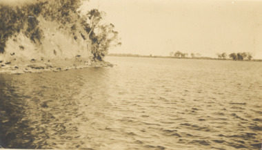
Photograph - Steep bluff, Mission Lake Tyers Victoria, 1926 c
Sepia toned photograph of steep bluff opposite jetty at Mission Lake Tyers Victoriawaterways, topography -
 Lakes Entrance Historical Society
Postcard - Lake Tyers, Valentine Series 1071, 1950c
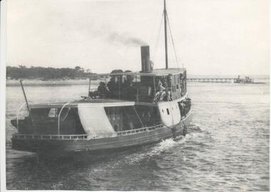
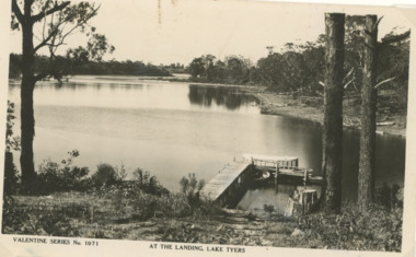
Also a colour postcard from same viewpoint at a later date taken by Viewpoint Productions purchased from B Roche number 03828.1 size 9 x 13.5 cmBlack and white postcard of tourist launch at jetty Fishermans Landing Lake Tyers VictoriaValentine Series No 1071 At the Landing Lake Tyersboats and boating, forest, waterways -
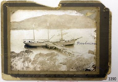 Flagstaff Hill Maritime Museum and Village
Photograph, before 1911
Photograph, black and white, of the three-masted barque SPECULANT at a jetty in low water. On the jetty and the shore are stacks of cut timber. The ship is in a wide river or bay, hills in the background, trees (like gum trees) in the foreground. Inscribed "Wrecked 10.2.11. Cape Patten. Jacobson. Munro. - - - -" Written on the photograph in blue pen "Rosbercon". (The SPECULANT was wrecked on 10th February 2011 at Cape Patton, Victoria, (not Patten as on the photograph). She was sailing under the control of Captain James Jacobsen and her First Mate was James Mumro.) The barquentine SPECULANT was a steel, three-masted sailing ship built in 1895 in Inverkeithing, Scotland, registered in Warrnambool, Victoria and wrecked at Cape Paton, Victoria, 10th February 1911. The SPECULANT had been involved in the timber trade between the United Kingdom and Russia, until sold to its Warrnambool owners and timber merchants Messrs. P.J. McGennan & Co. (Peter John McGennan) in 1902 for 3000 pounds and had her sailed to Warrnambool as her new port. Peter John McGennan was born in 1844 and worked as a builder and cooper in Holyhead, Anglesea, Wales. He immigrated to Australia in 1869 as a free settler and arrived in Warrnambool in 1871 and undertook management of a property in Grassmere for Mr. Palmer. Peter met his wife Emily in South Melbourne and they married in 1873. They had ten children including Harry who lived to 1965, and Andrew who lived until 1958. (The other children were their four brothers - John who was killed in the Dardenalles aged 35, Frederick who died aged 8, Peter who died aged 28, Frank who died aged 5 weeks - and four sisters - Beatrice who died age 89, Edith who died aged 49, Blanche who died aged 89 and Eveline who died aged 48.) In 1874 Peter starting a boating establishment on the Hopkins River. In 1875 he opened up a Coopers business in Kepler Street next to what was Bateman, Smith and Co., moving to Liebig Street, next to the Victoria Hotel, in 1877. In 1882 he then moved to Lava Street (which in later years was the site of Chandlers Hardware Store). He was associated with the establishment of the Butter Factory at Allansford. He started making Butter Boxes to his own design and cheese batts for the Butter Factory. In 1896 established a Box Factory in Davis Street Merrivale, employing 24 people at its peak, (it was burnt down in 1923); and in Pertobe Road from 1912 (now the Army Barracks building). Peter was a Borough Councillor for Albert Ward from 1885 to 1891, he commenced the Foreshore Trust (including the camping grounds along Pertobe Road), and he was an inaugural Director of the Woollen Mill in Harris Street, buying an extensive share-holding in 1908 from the share trader Edward Vidler. They lobbied the Town Hall to have a formal ‘Cutting’ for the waters of the Merri River to be redirected from its natural opening south of Dennington, to its existing opening near Viaduct Road, in order to have the scourings from the wool at the Woollen Mill discharged into the sea. He sold Butter Boxes around the state, and had to ship them to Melbourne by rail. Peter’s purchase of the SPECULANT in 1902 enabled him to back-load white pine from Kaipara, New Zealand to Warrnambool to make his butter boxes then, to gain profitability, buy and ship potatoes and other primary produce bound to Melbourne. (McGennan & Co. had also owned the LA BELLA, which had traded in timber as well, until she was tragically wrecked with the loss of seven lives, after missing the entrance channel to Warrnambool harbour in 1905. It appears that the SPECULANT was bought to replace the LA BELLA.) In 1911 the SPECULANT had been attempting to depart Warrnambool for almost the entire month of January to undergo docking and overhaul in Melbourne. A month of east and south-easterly winds had forced her to remain sheltered in Lady Bay, Warrnambool apart from one morning of northerlies, when an attempt was made to round Cape Otway; she had to return to shelter in Portland after failing to make any headway. With only 140 tons of sand ballast aboard, the ship would not have been easy to handle. Captain Jacobsen and his crew of nine, mainly Swedes, decided to make for Melbourne, leaving Portland Harbour on 5th February 1911. By the 9th they had reached Cape Otway, where they encountered a moonless night, constant heavy rain, and a heavy sea with a south-easterly wind blowing. After safely rounding Cape Otway the course was changed to east, then north-east to take the vessel to a point six miles off Cape Patton, following the orders of Captain Jacobsen, who told the crew to be very careful with the steering, as the wind and sea was running to leeward. The patent log (used to measure speed) had been out of order for the last four months as no-one in Warrnambool was able to fix it: it was intended to have it repaired in Melbourne. In the meantime the crew measured the vessel's speed by looking over the side and estimating wind strength. This compounded the difficulties of imprecise positioning, as the strong cross wind and sea were acting on the lightly laden vessel to steadily drive it towards the shore. At 3.30am on Friday 10 February 1911 Captain Jacobsen and the first mate were looking over the side of the vessel when they heard the sound of breakers and suddenly struck the rocks. The crew immediately knew they had no chance of getting the SPECULANT off, and attempted to rescue themselves by launching the lifeboat, which was instantly smashed to pieces. One of the crew then volunteered to take a line ashore, and the rest of the crew were all able to drag themselves to shore, some suffering hand lacerations from the rocks. Once ashore they began to walk along the coast towards Lorne, believing it was the nearest settlement. Realising their mistake as dawn broke they returned westwards to Cape Patton, and found a farm belonging to Mr C. Ramsden, who took them in and gave them a change of clothes and food. After resting for a day and returning to the wreck to salvage some of their personal possessions, at 10am on Saturday they set out for Apollo Bay, a voyage that took six hours, sometimes wading through flooded creeks up to their necks. The Age described the wreck as "listed to starboard. All the cabin is gutted and the ballast gone. There is a big rock right through the bottom of her, and there is not the slightest hope of getting her off". A Board of Marine inquiry found that Captain Jacobson was guilty of careless navigation by not taking steps to accurately verify the position of the vessel with respect to Cape Otway when the light was visible and by not setting a safe and proper course with respect to the wind and sea. It suspended his certificate for 6 months and ordered him to pay costs. The location of the wreck site was marked for a long time by two anchors on the shoreline, until in 1970 the larger of the two anchors was recovered by the Underwater Explorers' Club and mounted on the foreshore at Apollo Bay. The bell from the wreck was also donated to the Apollo Bay Surf Lifesaving Club but is recorded to have been stolen. Rusting remains of the wreck can still be found on the shoreline on the southern side of, and directly below Cape Patton. Parts of the SPECULANT site have been buried by rubble from construction and maintenance works to the Great Ocean Road, as well as by naturally occurring landslides. Peter J McGennan passed away in 1920. The Gates in the western wall of the Anglican Church in Henna Street/Koroit St are dedicated to him for his time of community work, which is matched with other prominent Warrnambool citizens; Fletcher Jones, John Younger, J.D.E (Tag) Walter, and Edward Vidler. After Peter J McGennan's death Harry, Andrew and Edith continued to operate the family business until July 11th 1923 when the company was wound up. (Andrew lived in Ryot Street Warrnambool, near Lava Street.) Harry McGennan (Peter and Emily’s son) owned the Criterion Hotel in Kepler Street Warrnambool (now demolished). His son Sid and wife Dot lived in 28 Howard Street (corner of Nelson Street) and Sid managed the Criterion until it was decided by the family to sell, and for he remained Manager for the new owners until he retired. Harry commenced the Foreshore Trust in Warrnambool around 1950. The McGennan Carpark in Pertobe Road is named after Harry and there are Memorial-Stone Gates in his memory. (The Gates were once the original entrance to the carpark but are now the exit.). Peter’s great-grandson, also called Andrew, is a Security Officer in Warrnambool. The Patent Log (also called a Taffrail log) from the SPECULANT, mentioned above, and a number of photographs, are now part of the Collection at Flagstaff Hill Maritime Village. The SPECULANT is historically significant as the largest ship to have been registered in Warrnambool, and is believed to have been the largest barquentine to visit Melbourne. It is evidence of the final days of large commercial sailing vessels involved in the Victorian and New Zealand timber trade. The SPECULANT is listed on the Victorian Heritage Register VHR S626Photograph, black and white, of the three-masted barque SPECULANT at a jetty in low water. On the jetty and the shore are stacks of cut timber. The ship is in a wide river or bay, hills in the background, trees (like gum trees) in the foreground. Inscribed below photograph "Wrecked 10.2.11. Cape Patten. Jacobson. Munro. - - - -" Written on the photograph in blue pen "Rosbercon"Inscribed below photograph "Wrecked 10.2.11. Cape Patten. Jacobson. Munro. - - - -" Written on the photograph in blue pen "Rosbercon"flagstaff hill, warrnambool, shipwrecked-coast, flagstaff-hill, flagstaff-hill-maritime-museum, maritime-museum, shipwreck-coast, flagstaff-hill-maritime-village, warrnambool historical photograph, cape patten, munro, james munro, la bella, speculant, cumming and ellis, international timber trade, p. j. mcgennan and co. warrnambool, peter mcgennan, capt. james jacobsen, warrnambool maritime history -
 Glenelg Shire Council Cultural Collection
Postcard - Postcard - The Harbour, Portland, n.d
Black and white photographic image of a harbour with two long piers running into it and a shorter jetty with a building on it and circular jetty protruding from it. In the foreground are trees, a dirt road with an RACV sign bridging it to the foreground right and a railway track visible between the trees.Front: THE ROSE SERIES P. 10771/ COPYRIGHT (typed, lower left) THE HARBOUR, PORTLAND (typed, lower centre) -
 Lakes Entrance Historical Society
Photograph - Business, Lakes Post Newspaper, 1998c
Black and white photograph of the North Arm, showing hire boat jetty covered with flood waters caused by a high tide, four hire boats and rowing boat at jetty. House visible on top of Kalimna Heights in background. Lakes Entrance Victoriaboats and boating, tourism, businesses -
 Phillip Island and District Historical Society Inc.
Photographs, 1926
Part of a collection of photographs out of an old photo album with multiple photos on each page. Donated by Margaret Webster. Margaret's parents were Sir Charles & Lady McGrath who lived near the RSL in Ventnor Road, Cowes.286-18 - Sepia photograph of The Tea Room at Shelly Beach, Phillip Island or San Remo?. Two men, a lady and dog beside two cars. One car has a woman inside. 286-19 - Sepia photograph of a group of 13 people in coastal scrub land at Shelly Beach. 286-20 - Sepia photograph of a group of 13 people in coastal scrub land at Shelly Beach. 286-21 - Sepia photograph of a group of people having a picnic in front of the San Remo Hotel. 286-22 - Sepia photograph of 3 people at The Nobbies, Phillip Island. 286-23 - Sepia photograph of rough seas at The Nobbies, Phillip Island. 286-24 - Sepia photograph of a man with a young penguin possibly at Slummerlands Phillip Island. 286-25 - Sepia photograph of breakers at The Nobbies, Phillip Island. 286-26 - Sepia photograph of The Continental Guesthouse with guests on the verandah. 286-27 - Sepia photograph of an unmade road with scrub vegetation on the sides. 286-28 - Sepia photograph of Cowes foreshore with the Jetty in the background. 286-29 - Sepia photograph of the Cowes Jetty with people arriving off a ferry. 286-30 - Sepia photograph of Cowes foreshore with the Jetty in the background and a ferry.286-18 - "The Teahouse - Shelly Beach" 286-19 - "A Confidential Chat - Shelly Beach" 286-20 - "The Wanders - San Remo" 286-21 - "Lunch at San Remo" 286-22 - "The Nobbies - P.I." 286-23 - "Rough Seas - The Nobbies" 286-24 - "A Young Penguin" 286-25 - "Breakers - The Nobbies" 286-26 - "The Contin - Cowes" 286-27 - "The Road to the Back Beach" 286-28, 29 & 30 - "Beach and Jetty at Cowes"the nobbies phillip island, young penguins, wildlife - penguins, tea house behind shelly beach, shelly beach, san remo hotel, the continental guesthouse, the continental hotel, cowes jetty, margaret webster -
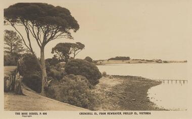 Phillip Island and District Historical Society Inc.
Photograph - Post Card, Early 20th Century
One of a collection of 11 photographs/postcards donated by Meg Davis & Nancy McHaffie from the estate of Brenda Higgins, grand-daughter of JD & Georgianna McHaffieBlack & White postcard of Churchill Island in the background taken from Newhaven foreshore. Jetty in the foreground.The Rose Series P. 696. Churchill Is., from Newhaven, Phillip Is., Victoriachurchill island, newhaven, newhaven phillip island, meg davis, nancy mchaffie, brenda higgins