Showing 10884 items
matching land
-
 Ringwood and District Historical Society
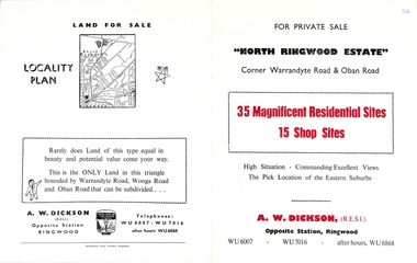
Flyer, Land Sale Brochure, North Ringwood Estate, Ringwood, Vic. - 1958
Double-sided land sale advertisement for sale of 35 residential and 15 shop sites on the corner of Warrandyte Road and Oban Road, Ringwood North, Vic., including locality plan and features of the estate.Subdivision includes Oban Road, Warrandyte Road, and Dickson Crescent. Agent: A.W. Dickson, Opposite Station, Ringwood. (Phone) WU6007, WU7016, after hours WU6868. -
 4th/19th Prince of Wales's Light Horse Regiment Unit History Room
Booklet, Land Warfare Procedures - General. Field Health & Hygiene Handbook, 2001
Spiral bound pocket sized booklet. The aim of the publication is to provide direction on field health and hygiene in order to reduce significantly the number of disease and non-battle injuries and their impact on land-based operationsLWP - G 1-2-2health, hygiene -
Ringwood and District Historical Society
Commercial papers, Aird, J.G, Papers re Land Purchases and transfers between J.G.Aird and others 1919-1924, 1919-1924
Details of monies paid to J.G. Aird and handled by him in connection with the sale of lands.2 bundles of papers pertaining to the collection of monies involved in land purchases and transfers between Mr. J.G. Aird and other parties stapled together in brown folder. +Additional Keywords: Aird, J.G. -
 Ringwood and District Historical Society
Flyer, Land Sale Advertisement - East Ringwood Township Estates, East Ringwood, Victoria - circa 1920
The date of the flyer as circa 1920 can be estimated from the references to the (decision on) "electrification of the Croydon Railway Line" which eventually occurred in 1923, letting of tenders for the state school building which opened in 1924, and the "proposed new railway station" (East Ringwood) which opened in 1925, Advertisement for three retail and residential allotment land sales in East Ringwood Township including maps showing layout of subdivisions. Township Estate, State School Estate, and East Ringwood Station Estate.Subdivision plans include Mount Dandenong Road, Grey Street, Eastfield Road, King Street, Everard Road, Holland Road, Purser Avenue, and Charles Street. (Agents) Spencer Jackson, Subdivider & Homebuilder, 341 Collins Street, Melbourne, Phones: M2327 (3 lines), also at Dromana, Phone 65. -
 Coal Creek Community Park & Museum
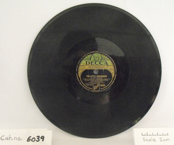
Gramophone Record, Never Never Land / The Little Shoemaker
Gramophone record, black bakelite with cream and green "Decca" label. Side A: Never Never Land, Side B: The little Shoemaker. Frank Weir & his Saxophone and Orchestra. Vocal by the Michael Twins.Reference Number Y6605 -
 Whitehorse Historical Society Inc.
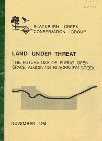
Document, Land under threat, 1981
'Land under threat: the future use of public open space adjoining Blackburn Creek' by Blackburn Creek Conservation Group, November 1981.'Land under threat: the future use of public open space adjoining Blackburn Creek' by Blackburn Creek Conservation Group, November 1981. Includes detailed descriptions, plans, bird lists, correspondence.'Land under threat: the future use of public open space adjoining Blackburn Creek' by Blackburn Creek Conservation Group, November 1981.blackburn creek, parks and reserves, kalang park, furness park, environment, blackburn creek conservation group, blacks walk, blackburn creeklands, melbourne and metropolitan board of works, city of nunawading, burgess, graham -
Whitehorse Historical Society Inc.
Document, Schwerkolt Land Documents, 1/09/1998
Photocopies of documents relating to land purchased by Johann August Schwerkolt from Patrick Riley on which the cottage was built and sold to the City of Nunawading in 1964 by Marie Elizabeth Jackschowsky. Contents list with documents.land subdivision, land titles, schwerkolt, johann august, maria catherina wilhelmine, carl benno, louis, jackschowsky, mary elizabeth, edgerton, charles, riley, patrick, john, kruse, deep creek road, mitcham, city of nunawading, edgerton road -
 Whitehorse Historical Society Inc.
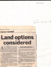
Newspaper - Article, Land options considered, 11/04/1994
Article from the Gazette, 11 April 1994, on Nunawading Council interest in buying 4.6 ha. of land between Yarran Dheran and Schwerkolt Cottage from Melbourne Water by Katy Ahley- Griffiths.yarran dheran, schwerkolt cottage, melbourne water -
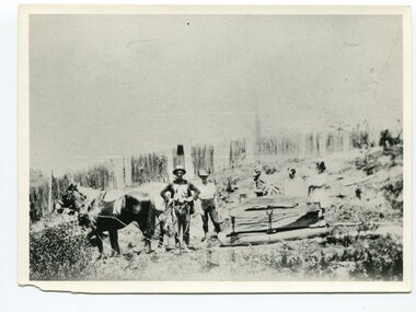 Orbost & District Historical Society
black and white photograph, late 19th century - early 20th century
This photograph shows land clearing at Bendoc. From 1845 the Bendoc area was part of pastoral leases. In the 1850s alluvial gold was discovered in the Bendoc River. This was quickly exhausted, and a number of mines began successful reef operations. At the head of the river, the settlement of Clarkville clustered round several other mines. Many miners, including numbers of Chinese, sluiced the rivers. The population of the area was as high as 500 during this period. The township was surveyed in 1869 and the hotel built in 1870. This building was burnt down in the early 1900s and rebuilt. A school was also begun at this time. In the 1870s there was a decline in gold mining. Some miners selected land, which in many cases is still held by descendants. Dairying was common in the early days, supplying a butter factory at the New South Wales border, and a milk factory at Orbost in more recent times. Wheat was grown for the settlers' own use and ground at Bombala. Now beef cattle grazing is the main occupation. (info. from Victorian Places)This is a pictorial history associated with the early settlement of Bendoc in East Gippsland.A badly distorted black / white photograph of a horse drawn wagon, three men and two women clearing land.on back - "Clearing land at Bendoc"bendoc-land-clearing bendoc-early-settlement -
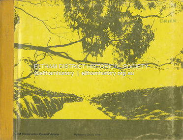 Eltham District Historical Society Inc
Book, Land Conservation Council, Report on the Melbourne Study Area, December 1973
This report is one of a series describings the physical nature of the land and its environment, examines the likely forms of land use, and assesses the hazards associated with these uses. It is divided into four main sections: Introduction, Characteristics of environment, main forms of land use and description of 24 specific blocks in the study area which include Torquay, Brisbane Ranges, Werribee, Wombat, Loddon, Romsey, Puckapunyal, Strathbogie, Eildon, Disappointment, Break O'Day, Black Range, Cerberean, Upper Goulburn, Kinglake, Donna Buang, Upper Yarra, Thomson, Dandenongs, Bunyip-Latrobe, Shady Creek, Tyers, Westernport and Strzelecki. The Land Conservation Act 1970 established the Land Conservation Council whose functions is to "carry out investigations and make recommendations to the Minister with respect to the use of public land in order to provide for the balanced use of land in Victoria. This report sets out to describe and assess the natural resources of the public lands in the Melbourne area and provides a factual basis on which members of the community may base submissions to the [Land Conservation] Council of Victoria.444 pagesnon-fictionThis report is one of a series describings the physical nature of the land and its environment, examines the likely forms of land use, and assesses the hazards associated with these uses. It is divided into four main sections: Introduction, Characteristics of environment, main forms of land use and description of 24 specific blocks in the study area which include Torquay, Brisbane Ranges, Werribee, Wombat, Loddon, Romsey, Puckapunyal, Strathbogie, Eildon, Disappointment, Break O'Day, Black Range, Cerberean, Upper Goulburn, Kinglake, Donna Buang, Upper Yarra, Thomson, Dandenongs, Bunyip-Latrobe, Shady Creek, Tyers, Westernport and Strzelecki. The Land Conservation Act 1970 established the Land Conservation Council whose functions is to "carry out investigations and make recommendations to the Minister with respect to the use of public land in order to provide for the balanced use of land in Victoria. This report sets out to describe and assess the natural resources of the public lands in the Melbourne area and provides a factual basis on which members of the community may base submissions to the [Land Conservation] Council of Victoria.land use, kinglake, thomson valley, conservation, public lands -
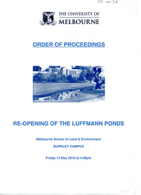 University of Melbourne, Burnley Campus Archives
Programme, Melbourne School of Land and Environment et al, Re-Opening of the Luffmann Ponds, 14.05.2010
Refurbishment of the Luffmann Ponds joint venture between the Friends of Burnley Gardens and The University of Melbourneluffmann ponds, refurbishment, ceremony, friends of burnley gardens, melbourne school of land and environment, alex cherney, barry jones, john fordham, plaque -
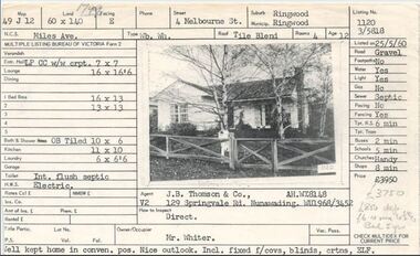 Ringwood and District Historical Society
Document, Property profile for sale of house and land, 4 Melbourne Street, Ringwood, Victoria - 1960
The house was owned by Mrs. Jessie White 4, Melbourne St. on the corner of Miles Ave. now both lost in the development of Eastland Shopping Centre.Details include map reference, dimensions of land and living space, picture of house, details of local services. Owner/Occupier Mr. Whiter. Agent J.B. Thomson & Co., 129 Springvale Road, Nunawading. -
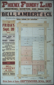 Federation University Historical Collection
Photograph - Colour, Photograph of the Phoenix Foundry Land Sale Poster, 1907, 1907
Photograph of a poster advertising the auction of Phoenix Foundry Land located on the corner of Armstrong, Doveton and Dana Streets in Ballarat held on 20 September 1907 by Bell, Lambert and Co., auctioneers of Lydiard Street, Ballarat.phoenix foundry, ballarat, newton's hotel, coles and pullum, sale yards, snow's corner, bazaar hotel, stork hotel, jordon and tippett, reid's stables, town hall hotel, mead and co, smith, mather, gazzard, coffee palace, whykes, dimond building, rowland's factory, hunter, hunter daniel & co, ballarat brewing company, tulloch, armstrong street south, doveton street south, dana street -
Port Melbourne Historical & Preservation Society
Legal Record, Act to authorise The Melbourne and Hobsons Bay Railway Company to sell their undertaking and property and to vest the same in the Board of Land and Works for other purposes, 20 Jan 1853
Victorian Parliamentary Act "to authorise The Melbourne and Hobsons Bay Railway Company to sell their undertaking and property and to vest the same in the Board of Land and Works for other purposes" 14 November 1878: 13pp photocopy of Acttransport - railways, parks and gardens, melbourne & hobsons bay railway company, melbourne & hobsons bay united railway company -
University of Melbourne, Burnley Campus Archives
Magazine - Journal articles, Land & Environment, 2010
cas mclean, green roofs, nerissa hannink, luffman ponds, luffmann ponds -
Lakes Entrance Historical Society
Book, Land Conservation Council Victoria East Gippsland Study Area, 1974
Report describing the nature of environmental features, together with the character and distribution of various natural resources of the East Gippsland, Victoria, study area, comprising land in the old Shire of Orbost. History, vegetation, flora, fauna,vegetation, natural history, vegetation -
 Ringwood and District Historical Society
Document - Folder, Land Sale - Monterey Park Subdivision, Warrandyte Road, Ringwood North, Vic. - 1981
Foolscap manilla folder containing double-sided flyer advertising residential subdivision development, including outline of local facilities and services, with locality map and layout of Monterey Park streets. Subdivision includes Parkwood High School, Tortice Drive, Heape Way, Appleberry Place, Stringybark Court, Conifer Court, Crawley Grove, Monterey Close (later Monterey Place), Lucy Place, Middlebrook Drive, Gahnia Close, Glanfield Court, Cone Close, Jull Parade, Pinus Close (later Pinetree Court), Radiata Close, Old Warrandyte Road, and entry from Warrandyte Road. Vendor - Jennings Industries Limited, 690 Springvale Road, Mulgrave, 3170, Phone 5618000. A4 enclosures with tables showing each allotment List Price, Builders Price, Cash Price and Terms Price. Information page headed "Form of Restrictive Covenant to be incorporated in Transfer" specific to Certificates of Title. Restrictive Covenant (summary): (Name/s) "... will not erect or construct or cause to be erected or constructed on the land hereby transferred (a) Any front boundary fence, other than a fence which does not exceed one metre in height unless the same is set back as least 1.5 metres from the front boundary and the same is effectively screened from that boundary by the planting of trees, shrubs or plants. (b) Any side boundary fence other than a fence which is set back at least 1.5 metres from the front boundary on which does not exceed 1 metre in height within 1.5 metres of the front boundary. (c) For a period of 5 years from the date hereof, any building on the said land unless and until the Plans and Specifications thereof have first been approved by the said Residential Developments Pty. Limited. (d) For a period of 2 years from the date hereof whilst the said land remains vacant any Signboard or Notice advertising the sale of the said lot or any other lot. These covenants shall appear on the Certificate of Title to issue for the said land and run with the land." -
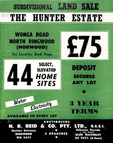 Ringwood and District Historical Society
Flyer, Land Sale Brochure, The Hunter Estate, North Ringwood, Vic. - circa 1960
Bi-fold land sale advertisement for The Hunter Estate, North Ringwood, including terms of sale, area map, layout of the estate, and summary of local facilities and services, with separate attachment listing lot number prices.Subdivision includes Wonga Road, Hunter Avenue (later Graeme Avenue), Panfield Avenue, Hendra Grove, and Mullum Mullum Road. Agent - N.R. Reid & Co. Pty. Ltd., Station Entrance, Ringwood. (Phone) WU 6661. -
Ringwood and District Historical Society
Work on paper - Letter, Letter from W. Meyland to Mr. Hookey re land in East Ringwood for school. 1969, 22-Jul-69
2-page letter from W. Meyland to Mr. Hookey re land in East Ringwood. School was opened 6-Aug-1924 by Mrs. Everard. +Additional Keywords: Meyland, Charles / Hookey / Lindsay, Ted. -
 Whitehorse Historical Society Inc.
Document - Report, Nunawading land, 01/10/1855
Photocopies of 3 sheets of documents in the Public Record Office listing the first land purchases in Nunawading. Headed: 'Final Report of a sale by public auction of suburban and country lands held at Melbourne on the 22nd October 1855'.williams, william, cousens, james, heading, nalborough, phillip, riley, patrick, blood, thomas, cook, holland, john, lobb, burrell, charles, land subdivision -
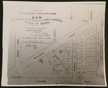 Kew Historical Society Inc
Print - Subdivision Plan, F Price, Plan of Mr William Derrick's Land, Kew being Subdivision of Part of Section 86, Parish of Boroondara, County of Bourke, 1872, 1872 [Original]
This work forms part of the collection assembled by the historian Dorothy Rogers, that was donated to the Kew Historical Society by her son John Rogers in 2015. The manuscripts, photographs, maps, and documents were sourced by her from both family and local collections or produced as references for her print publications. Many were directly used by Rogers in writing ‘Lovely Old Homes of Kew’ (1961) and 'A History of Kew' (1973), or the numerous articles on local history that she produced for suburban newspapers. Most of the photographs in the collection include detailed annotations in her hand.The Rogers Collection provides a comprehensive insight into the working habits of a historian in the 1960s and 1970s. Together it forms the largest privately-donated collection within the archives of the Kew Historical Society.A photographic reproduction of a plan in the Vale Collection of the State Library of Victoria showing William Derricks land in the area bordered by Bulleen Road (High Street); Cotham Road and Union Street. The plan dates from 1872.william derrick, subdivision plans -- kew (vic.) -
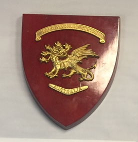 The 5th/6th Battalion Royal Victoria Regiment Historical Collection
Plaque - Presentation Plaque, Land Warfare Centre Australia
Shield shaped plaque made od a red varnished wood with a gold badge of a seven headed dragon affixed to the centre above the dragon is a banner with " Land Warfare Centre" and below it is a boomerang pointed down with "Australia" on itland warfare centre australia -
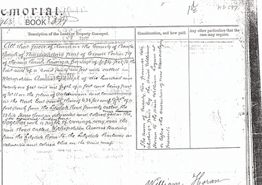 Whitehorse Historical Society Inc.
Document, Land Sale, n.d
Extract from Memorial Book 377 No 963 recording conveyance of land bounded by Whitehorse Road and Metropolitan Avenue,Photocopy from extract from Memorial Book 377 No 963 recording conveyance of land bounded by Whitehorse Road and Metropolitan Avenue, part Crown Portion 79, Parish of Nunawading from William Logan to William Horan.Extract from Memorial Book 377 No 963 recording conveyance of land bounded by Whitehorse Road and Metropolitan Avenue,metropolitan avenue, nunawading, whitehorse road, logan, william, horan, land sales -
 Greensborough Historical Society
Genealogical Document, Family records: various sources, 06/02/1854o
Family details collected and transcribed from various sources: rolls, directories, insolvency lists, etc. Families include: Mayger, Lecky, Britnell, Garthwaite, Green, Beale, Coulstock, Sherwin, Batey, Cobham, Partington, Catchpole, Whatmough. Item 365 contains transcript of land ownership in Greensborough area 1840-1906.One page of details transcribed from various rolls and directories. Also Item 365 Land ownership 1840-1906.Land ownership notes are hand written.greensborough, mayger, lecky, britnell, garthwaite, green, beale, coulstock, sherwin, batey, cobham, partington, catchpole, whatmough. -
![Sign, Regulations for the Care, Protection and Management of the " Penguin Reserve" at Phillip Island [ As amended ] 1956 and 1968, 1956 and 1968](/media/collectors/4f729f5b97f83e0308601629/items/6476aa1f1e1a2671cef44090/item-media/6476ab3b1e1a2671cef4be40/item-fit-380x285.jpg) Phillip Island and District Historical Society Inc.
Phillip Island and District Historical Society Inc.Sign, Regulations for the Care, Protection and Management of the " Penguin Reserve" at Phillip Island [ As amended ] 1956 and 1968, 1956 and 1968
Board of Land and Works reserved land on Phillip Island by Orders in Council in December 1955 and June 1956 as sites for a penguin rookery and known as the Penguin Reserve.HistoricalLarge cream cloth sign with black print outlining regulationswildlife - penguins, penguin reserve, phillip island nature park, signs -
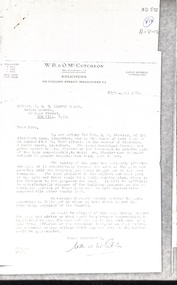 Whitehorse Historical Society Inc.
Letter - Correspondence, Land Acquisition - Mason Road, 21/04/1938
Letters between Real Estate Agent (T.R.B. Morton & Son) and Solicitor (W.B. & O.M. McCutcheon) concerning acquisition of land by the local municipal council from Mrs M.L. Wheeler at the corner of Mason Road and Blackburn Road, Blackburnland sales, wheeler, m. l. (mrs), blackburn road, blackburn, masons road -
Lakes Entrance Historical Society
Book, Land Conservation Council Victoria South Gippsland Area District 2, 1980
Report describing and assessing the natural resources of the public land in the South Gippsland (Victoria) Study Area 2, comprising the Latrobe Valley, Strzelecki Range, South Gippsland coastal plains and all of Wilson's Promontory. History, Geology, floRuth Clarkgippsland, topography, natural history, vegetation -
Lakes Entrance Historical Society
Book, Baxter Carol J, General Musters of New South Wales Norfolk Island and Van Diemens Land, 1987
A list of convicts and residents of New South Wales, Norfolk Island, and Van Diemens Land taken from General Musters showing name, whether convict or ree ship of arrival, and other information of value to researchers and family historians.convicts, settlers, statistics -
 Orbost & District Historical Society
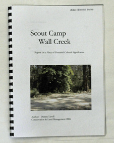
book, Scout Camp Wall Creek, 2006
This report was written by Dianne Lavell for the Department of Conservation and Land Management. Dianne Lavell worked for the Department of Conservation and Land Management in Orbost. She was a long time resident of Orbost. A spiral bound, plastic covered book titled Scout Camp Wall Creek. It is a report on Scout Camp at Wall Creek in Orbost. It contains description and history of the site deemed to be a place of potential cultural significance. on the front cover is a coloured photo of the site.scout-camp-wall-creek -
 Orbost & District Historical Society
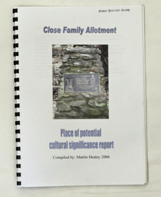
book, Close Family Allotment, 2006
This report was compiled by Martin Healey for the Department of Conservation and Land Management, Victoria. Martin Healey, a long time Orbost resident, worked for the Department of Conservation and Land Management in Orbost.This is a useful research tool.A small spiral bound book of 30 pp with a plastic cover. It is a report written by Martin Healey and details the close Family allotments at Murrangower, east of Orbost.