Showing 10928 items matching " plan"
-
 University of Melbourne, Burnley Campus Archives
Plan - Photocopy, Plan - Additions to Plant Research Laboratory (1) , Extension to Plant Research Laboratory for the Department of Agriculture, Burnley Gardens (2 & 3), 1952 -53
University of Melbourne Property and Services has better copies Photocopies, reduced in size, of original plans. Signed by Dept of Public Works, Chief Architect. (1) and (2) dated 14.08.1953 (1) UCB.2.123 North Elevation, Perspective Sketch, Plan. (2) UCB.2.142₃ Floor plan. (3) UCB.2.157.0, dated 26.11.53, South Elevation Front (North) Elevation, West Elevation, Plan, Sections ₂. University of Melbourne - Property and Services has a better copy.plant research, laboratories, burnley gardens, victoria department of agriculture -
 Warrnambool and District Historical Society Inc.
Map, Plans (5) showing Subdivisions of Warrnambool, 1989
These plans have been drawn by Steve Hester for the Warrnambool City Council to illustrate the allotments in Warrnambool concerned with the subdivisions of 1989. The streets have not been named but there is an indication of the area with the identification of known buildings (eg Hospital) and the plan numbers of each allotment is clearly marked. These numbers corresponded to the plan numbers registered in card files and ledgers in the Warrnambool City Council offices. The scale of the plans was 1 to 5000. These plans are of considerable interest because they show Warrnambool street subdivisions of 1989 in illustrative form. They show how information was collated in the late 1980s before the widespread use of computer digital means to describe and store information.These are five hand-drawn sheets showing plans of sub-divisions in Warrnambool streets in 1989 (Warrnambool City Council material). The plans are multi-coloured (crayons) and show allotments with plan numbers. The first plan has much of the material torn off but the location is known to be in the Russells Creek area. Some of the green tape around the edges is missing. Plans two to five are almost intact and are bound with green tape. Plan Two- Industrial Estate of West Warrnambool; Plan Three – Hospital/Merrivale/ Lake Pertobe areas; Plan Four – North Warrnambool, Wollaston/Brierly areas; Plan Five – Flaxman Street area. ‘Subdivision Plan, Reference Guide, Steve Hester, Oct. 1989’. warrnambool street subdivisions, steve hester, history -
Port Melbourne Historical & Preservation Society
Plan - Port Melbourne Planning Scheme, Bayside Project Area, Development Plan. Comprehensive Development Zone No. 9 (Bayside Project Area). Local Section Port Melbourne Planning Scheme, Apr 1990
Development Plan. Comprehensive Development Zone No. 9 (Bayside Project Area). Local Section Port Melbourne Planning Scheme. 1990. Large white spiral bound folder.town planning - proposals shelved - bayside, local government - city of port melbourne, built environment, sandridge city development co pty ltd, scdc, beacon cove, mirvac -
University of Melbourne, Burnley Campus Archives
Plan, Plant Culture and Garden Maintenance Planting Plan Assignment, 1987-1988
(1) Plan on tracing paper of Mixed Border, plants not included, signed MG March '87. (2) Base Plan by MG, July 1988. Scale 1:100.gardens, maintenance, planting, plant culture, mixed border, victorian plant research institute, m. green -
 University of Melbourne, Burnley Campus Archives
Plan, E.M. Gibson, Revised Roads Plan for Burnley Gardens, 1951
(1) 8 copies Plan by E.M. Gibson. (2) Report to Accompany Master Garden Plan for Burnley Gardens by E.M. Gibson 1.12.1949. Includes all areas around new Administration Building. Refers to help from C.R.T.S. students. Note: Master Garden Plan itself not found.e.m. gibson, burnley gardens, crts, students -
Port Melbourne Historical & Preservation Society
Plan, Graeme Bentley Pty Ltd, Port Melbourne Foreshore Landscape Master Plan MP4 (B), February 1993
The Port Melbourne Foreshore Landscape Master Plan was created by Landscape Architectural firm of Graeme Bentley Pty Ltd for the City of Port Melbourne. MP4 (B) portrays the section of foreshore Surrounding the Port Melbourne Lifesaving Club.The plan proposed street tree planting and lawn areas. The plan was not actioned.built environment - recreational facilities, beach street, port melbourne foreshore, port melbourne life saving club -
Port Melbourne Historical & Preservation Society
Plan, Graeme Bentley Pty Ltd, Port Melbourne Foreshore Landscape Master Plan MP2 (A), February 1993
The Port Melbourne Foreshore Landscape Master Plan was created by Landscape Architectural firm of Graeme Bentley Pty Ltd for the City of Port Melbourne. MP2 (A) portrays the section of foreshore from Stokes Street to Dow Street. The plan proposed street tree planting along Beach Street. The plan was not actioned.built environment - recreational facilities, beach street, port melbourne foreshore, station pier -
University of Melbourne, Burnley Campus Archives
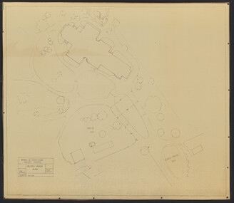
Plan - Sketch, Plan of Burnley Gardens, 1970-1980
Plans A and B. 2 identical hand drawn sketch plans of area bounded by manure bins, pumphouse to the east, milking shed and silo to the west: showing all buildings on the site.burnley gardens, buildings, burnley school of horticulture -
 Federation University Historical Collection
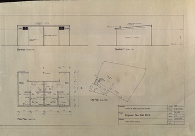
Plan, Ballarat School of Mines Proposed New Toilet Block, Barkly Street Campus, 1985, 16/08/1985
Plan showing plans for a toilet block at the former Ballarat East High School, Barkly Street.ballarat school of mines, barkly street campus, ballarat east secondary college, toilet block, architectural plans -
Federation University Historical Collection
Plan, Mount Helen Campus Plan, 1997, 1997
The Union Building was later named the Albert Coates Centre, and the Aboriginal Education Centre moved from T Building to the first floor of the Albert Coates Centre in 2011. Mount Helen Campus Plan showing the location of buildings and roads. mount helen campus, campus plan, union builidng, aboriignal education unit, albert coated building -
Federation University Historical Collection
Plan, Plan of Caxton Mine Battery Head, Smythesdale
Framed original plan of Caxton Mine battery head, Smythesdalecaxton mine battery head smythesdale, caxton mine, smythesdale, battery head, available -
 Queenscliffe Maritime Museum
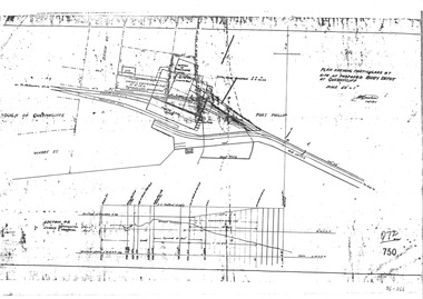
Plan - Proposed buoy depot at Queenscliffe 14/9/1926, Government Works plan of buoy depot proposal, 1926
Queenscliffe buoy depot locationHistorical details of proposed buoy depotphotocopy of a plan showing proposed buoy depot location 1926Reverse " NIL ".historical references -
University of Melbourne, Burnley Campus Archives
Plan, Sue Parker, Planting Plan Contemporary Garden, 1989
Coloured plan by Sue Parker Sheet No 5 dated 23.05.1989.sue parker, gardens -
 Federation University Historical Collection
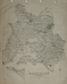
Plan, Mornington, 1926, 1926
Printed plan on papermornington, phillip island, western port bay, bass straight, wonthaggi, lang lang, sherwood, nepean, narre worran, ringwood -
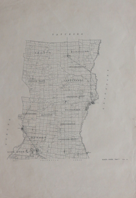 Federation University Historical Collection
Plan, Kara Kara
Printed plan on paperkara kara, tatchera, gladstone -
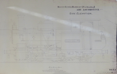 Federation University Historical Collection
Plan, Mount Lyell Railway (Tasmania) ABT Locomotive Side Elevation, undated
On 29 March 1893 the Mount Lyell Mining and Railway Company was formed. This Tasmanian mining company was often referred to as Mount Lyell. Mount Lyell, and was the dominant copper mining company of the Tasmanian West Coast from 1893 to 1994, and was based in Queenstown, Tasmania. After consolidation of leases and company assets at the beginning of the twentieth century, Mount Lyell was the major company for the communities of Queenstown, Strahan and Gormanston. It closed in 1994. The Mount Lyell mining operations produced more than a million tonnes of copper, 750 tonnes of silver and 45 tonnes of gold since mining commenced in the early 1890s – which is equivalent to over 4 billion dollars worth of metal in 1995 terms.Copy of a plan of a locomotive.mount lyell, locomotive, mount lyell railway, quuenstown, tasmania, strahan, gormamston, railway -
 Federation University Historical Collection
Plan, Ballarat School of Mines Trade Toilet Block Alterations and Renovations, 1976, 04/08/1976
Computer generated planballarat school of mines, toilet block -
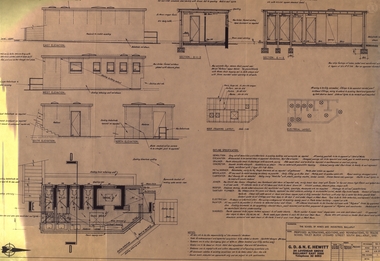
 National Wool Museum
Plan - Machinery Layouts, J Dyson & Sons Pty Ltd
Two machinery plan layouts for Mimosa Wool & Textiles Pty Ltd in Hobson's Road, Kensington.1617.1 Rectangular blue paper with white lined plan drawing and white text 1617.2 Rectangular blue paper with white lined plan drawing1617.1 Front: Final Plan / PLAN OF MACHINERY LAYOUT / MIMOSA WOOL & TEXTILES PTY LTD / HOBSON'S ROAD KENSINGTON / BY MESSRS J DYSON & SONS / SOUTH GEELONG / Scale 3/32" - 1.0"factory, machinery, wool, textiles, mill, kensington, south geelong, plans, drawings, blueprint, layout, mimosa, j. dyson and sons pty ltd -
 Kew Historical Society Inc
Map, MMBW, MMBW Plan No.66 Kew, 1900-1910
The Melbourne and Metropolitan Board of Works (MMBW) was established by an act of the Victorian Parliament in 1890 to prepare for and to implement a sewerage and water reticulation system across what was then inner Melbourne, its surrounding and middle distance suburbs, including Kew. The MMBW was disbanded in 1991.The map collection of the Kew Historical Society has at its core the historic maps assembled and originally stored in the City Engineer's Department of the City of Kew. These include maps in a number of scales. The vast majority of maps were produced by the MMBW in the first two decades of the twentieth century, and are solid working maps, backed by linen for durability. These maps are historically significant to Kew, the City of Boroondara and to the history of the development of state utilities in Victoria. A number of the Kew maps have additional details added by former municipal officers, including the levels reached by various floods. As these were working documents, information was added to them long after the period of their initial production and distribution.Early map of part of the Borough of Kew, created in the first decade of the twentieth century, at a scale 160 ft to 1 inch. The map covers what was then the south eastern part of Kew, bordered on its north by Adeney Avenue, in the west by Sackville Street, in the south by Barkers Road, and in the east by Burke Road. The map shows the extent of urban development by that time, prominent institutions and the outlines of built structures in the municipality. Contour lines were added in ink to the map at a later stage.MELBOURNE AND METROPOLITAN BOARD OF WORKS / PLAN NO. 66 / KEW melbourne & metropolitan board of works, mmbw maps, mmbw plans, borough of kew, cartography -
 Kew Historical Society Inc
Map, MMBW, MMBW Plan No.67 Kew, 1900-1910
The Melbourne and Metropolitan Board of Works (MMBW) was established by an act of the Victorian Parliament in 1890 to prepare for and to implement a sewerage and water reticulation system across what was then inner Melbourne, its surrounding and middle distance suburbs, including Kew. The MMBW was disbanded in 1991.The map collection of the Kew Historical Society has at its core the historic maps assembled and originally stored in the City Engineer's Department of the City of Kew. These include maps in a number of scales. The vast majority of maps were produced by the MMBW in the first two decades of the twentieth century, and are solid working maps, backed by linen for durability. These maps are historically significant to Kew, the City of Boroondara and to the history of the development of state utilities in Victoria. A number of the Kew maps have additional details added by former municipal officers, including the levels reached by various floods. As these were working documents, information was added to them long after the period of their initial production and distribution.Early map of part of the Borough of Kew, created in the first decade of the twentieth century, at a scale 160 ft to 1 inch. The map covers what was then the north central part of Kew, bordered on its north by the Outer Circle Railway Spruzen and Beresford Avenues, in the west by Princess Street, in the south by High Street, and in the east by (about) Belford Road. The map shows the extent of urban development by that time, prominent institutions and the outlines of built structures in the municipality. Contour lines were added in ink to the map at a later stage.MELBOURNE AND METROPOLITAN BOARD OF WORKS / PLAN NO. 67 / KEW melbourne & metropolitan board of works, mmbw maps, mmbw plans, borough of kew, cartography -
 Kew Historical Society Inc
Map, MMBW, MMBW Plan No.68 Kew, 1900-1910
The Melbourne and Metropolitan Board of Works (MMBW) was established by an act of the Victorian Parliament in 1890 to prepare for and to implement a sewerage and water reticulation system across what was then inner Melbourne, its surrounding and middle distance suburbs, including Kew. The MMBW was disbanded in 1991.The map collection of the Kew Historical Society has at its core the historic maps assembled and originally stored in the City Engineer's Department of the City of Kew. These include maps in a number of scales. The vast majority of maps were produced by the MMBW in the first two decades of the twentieth century, and are solid working maps, backed by linen for durability. These maps are historically significant to Kew, the City of Boroondara and to the history of the development of state utilities in Victoria. A number of the Kew maps have additional details added by former municipal officers, including the levels reached by various floods. As these were working documents, information was added to them long after the period of their initial production and distribution.Early map of part of the Borough of Kew, created in the first decade of the twentieth century, at a scale 160 ft to 1 inch. The map covers what was then the north central part of Kew, bordered in the north by Oak Avenue, in the west by the Yarra River and Connor's Creek, in the south by Beresford and Carnegie Avenues, and in the east by Glass's Creek and Burke Road. The map shows the extent of urban development by that time, prominent institutions and the outlines of built structures in the municipality. Contour lines and the levels of historic floods were added in ink to the map at a later stage.MELBOURNE AND METROPOLITAN BOARD OF WORKS / PLAN NO. 68 / KEW melbourne & metropolitan board of works, mmbw maps, mmbw plans, borough of kew, cartography -
 Bacchus Marsh & District Historical Society
Map, Plan of the second portion of the property of Messers Atkins and Clarke situate at Bacchus Marsh 1856
This plan of land allotments for sale indicates part of the property once owned by the Bacchus family in and around the township area of Bacchus Marsh. The Bacchus family sold their property in Bacchus Marsh to John Aitkins and Robert Nalder Clarke in March 1851. Aitkins and Clarke kept the property for a number of years until April 1856 when these allotments were put up for sale.This is a very early land sales plan for agricultural land close to the township of Bacchus Marsh. It therefore provides some clues as to how the early urban development of the township and agricultural development of the nearby area took place. Upon seeing the map in 1911 Bacchus Marsh Express newspaper editor Christopher Crisp wrote "The sale appears to have created the present township, which had a nucleus in earlier times further east", Express, 30 September, 1911, page 3.A single page paper plan showing allotments of land for sale. The subdivided land shown was owned by John Aitkins and Robert Nalder Clarke, but previously owned by the Bacchus Family and was in and around their Manor House (Mansion) property in Bacchus Marsh. This plan shows allotments in the second portion of land to be sold which was located east of the Manor House on the eastern side of the Lerderderg River. The land for sale was made up of 15 allotments. The plan is pasted into a bound volume containing 76 maps or plans in total. BMDHS Loc: AR/B12/S4 Bacchus Marsh Township and Nearby Districts Maps Volume In-house Digital copies: BMDHS, Computer Network: Maps\Bacchus Marsh Township and Nearby Districts Maps Volumebacchus marsh victoria maps, bacchus family, land sales, manor house bacchus marsh -
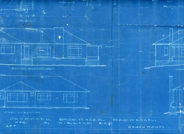 Ringwood and District Historical Society
Plan, Architects plan for residence in Balfour Avenue, Heathmont for Stan Wieland , no date
Stanley Wieland took over the property called "Fairview" at the corner of Dickasons Road and Canterbury Road, Heathmont after his Father's death in 1945. He married Thelma Wilson in 1930. Their daughter Pat wrote the Wieland History with her husband Don Talbot.Architect's plan on heavy blue paper for residence at Balfour Avenue , Heathmont -
Port Melbourne Historical & Preservation Society
Plan, B A Carter, Land Plan Primary School 1427 Port Melb, c. 1975
The design for extensive planting and landscaping of Nott Street Primary School, Port MelbournePlan of Landscape design for Nott Street Primary School, Port Melbourne.education - primary schools, nott street primary school -
University of Melbourne, Burnley Campus Archives
Plan, Graham Laurence, Preliminary Plan, 1995
Laminated landscape plan by Graham Laurence dated 24.08.1995, No 2 of 4.graham laurence, landscape design -
Federation University Historical Collection
Booklet, Federation University Strategic Plan, 2016-20, c2016
Federation University Australia was established on 1 January 2014. Formerly known as the University of Ballarat, its enabling legislation was the University of Ballarat Amendment (Federation University Australia) Act 2013. Although formally created as a University in 1994, the University of Ballarat has a lineage back to 1870 with the establishment of the School of Mines Ballarat, making it the third institution of higher learning to be established in Australia and the first to be established in regional Australia. On 1 January 1994, Ballarat University College became the University of Ballarat and in 1998 the University merged with three TAFE Institutes to become a dual sector institution with multiple campuses. On 1 January 2014, the University of Ballarat amalgamated with the Monash University Gippsland Campus to form Federation University Australia. The Gippsland Campus also had a long lineage dating back to 1928 with the establishment of the Yallourn Technical School which became a predecessor institution to the Gippsland College of Advanced Education formed in 1968. In 1990, it was renamed the Monash University College and in 1993 became the Gippsland Campus of Monash University. In 2016, Federation University Australia announced plans to take possession, over a two-year period, of Monash’s Berwick Campus in the south-east corridor of Melbourne. Federation University Australia, or FedUni, is headquartered in Ballarat and offers programs in Higher Education and Vocational Education and Training to regional Victoria and beyond. The University’s commitment to educational and social equity, teaching excellence, research distinction, environmental sustainability and regional capacity building has enabled it to develop in a way that draws on its proud heritage to inform its future. Its regional character sets a framework for the University’s priorities but does not constrain it from serving wider community interests, nationally and internationally. The name Federation University Australia was chosen to convey the scope and capacity of an expanded regional university with a federated network of campuses.A four year plan for the University of Ballaratfederation university, strategic plan, merger -
 Kew Historical Society Inc
Plan - Framed Subdivision Plan (copy), F Price, Plan of Mr William Derrick's Land, Kew being Subdivision of Part of Section 86, Parish of Boroondara, County of Bourke, 1872, 1872
William Derrick was an early landowner in Kew, and with James Venn Morgan and James Dannock the purchaser of the parcel of land bounded by Cotham Road, High Street and Mary Street. Derrick Street in Kew is named after him.Map mounted under perspex. ‘Plan of Mr Willia Derrick's Land, Kew being Subdivision of Part of Section 86, Parish of Boroondara, County of Bourke’. This is a copy of the plan held in the State Library of Victoria.kew subdivision plan, john derrick, subdivision plans -- kew (vic.) -
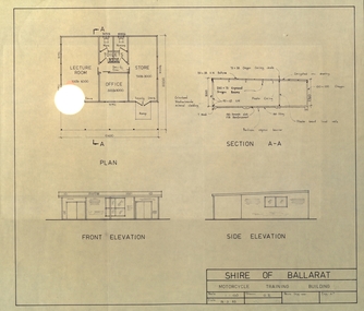 Federation University Historical Collection
Plan, Shire of Ballarat Motorcycle Training Building, 1983, 24/03/1983
Plan for the Shire of Ballarat Motorcycle Training Building shoing ground plan, Section A-A, Front Elevation and Side Elevation. shire of ballarat, motorcycle, motor bike -
Lakes Entrance Historical Society
Book, Vantree Pty Ltd Shearwater Environmetal Management, East Gippsland - Creating a Community Heritage Plan, 2002
This plan provides for the long-term Coastal Action Planwaterways, environment, tourism, boats and boating -
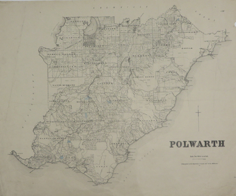 Federation University Historical Collection
Plan, Polwarth, 1927, 1927
Printed plan with hand colouringotway, polwarth, cape otway