Showing 40723 items
matching roads and streets
-
 Ringwood and District Historical Society
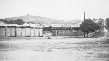
Photograph, Maroondah Highway Central, Ringwood. Bamford's Timber Yard, c1920
2 copies of photograph (1 black and white, 1 smaller sepia)Written on back of photograph: "Bamford, west corner of Warrandyte Road and Main Street". -
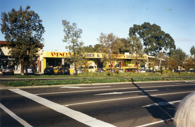
 Marysville & District Historical Society
Photograph (Item) - Colour photograph, Unknown
A colour photograph of Murchison Street in Marysville in Victoria.A colour photograph of Murchison Street in Marysville in Victoria.murchison street, marysville, victoria, photograph -
 Marysville & District Historical Society
Photograph (Item) - Colour photograph, Unknown
A colour photograph of Murchison Street in Marysville in Victoria.A colour photograph of Murchison Street in Marysville in Victoria.murchison street, marysville, victoria, photograph -
 Port Melbourne Historical & Preservation Society
Document - Specification, Tramway, Normanby Road, Ingles Street to Boundary Street, Port Melbourne, 14 Mar 1893
Written specification for works attached to plan of tramway in Normanby Road from Ingles Street to Boundary Street (Reg 66.1), 1893.A.V. Heath (Town Surveyor) J.J. Bartlett (Mayor)engineering - roads streets lanes and footpaths, transport - tramways, town planning, town clerks, mayors, arthur victor heath, james john bartlett -
Port Melbourne Historical & Preservation Society
Plan - Williamstown Road, Derham Street to Raglan Street, Port Melbourne, 14 Mar 1893
Plan of Williamstown road from Derham street to Raglan street. (67.1), together with written specification of works attached. (67.2), 1893.A.V. Heath (Town Surveyor). J.J. Bartlett (Mayor).engineering - roads streets lanes and footpaths, arthur victor heath, town clerks, james john bartlett, mayors -
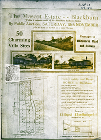 Whitehorse Historical Society Inc.
Document, Mascot Estate Blackburn
Subdivision of landSubdivision of land surrounded by Whitehorse Road, Simla street and King Street. 50 villa sites auctioned by M.Pullyn & Frank FisherSubdivision of land land subdivision, mascot estate blackburn, whitehorse road, blackburn, iona street, king street, simla street, pullyn, m, frank fisher & co. -
 City of Kingston
Photograph - Black and white, c. 1950
... Roads ...This image highlights the rural nature of the area during the 1950s where areas that are now major highways and intersections appear like country roads.Black and white photograph of the intersection of Warrigal Road and Centre Road in Oakleigh. There is a truck travelling south toward the camera along Warrigal Road which is a sealed road. On the right hand side is a Caltex petrol station with a street sign for Centre Road.Handwritten in blue ink on reverse: 2191 Handwritten in red ink on reverse: 72%oakleigh, cars, roads, suburbs -
 Bendigo Historical Society Inc.
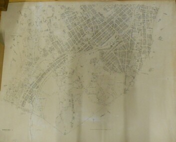
Map - BENDIGO SHEET 2
Parish map showing the southern section of the City of Bendigo. It shows the city boundary running along Murphy Street, Grave (Patterson) Street, and the turns at the south end of Macdougall Road, the corner of Alder and Aspinal Streets and the corner near the Specimen Hill - Marong roads intersectionH.J. Green Govt. Printer, Melbournemap, bendigo, city streets, parish map, city boundary -
 Whitehorse Historical Society Inc.
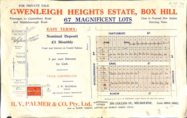
Document, Gwenleigh Heights Estate, Box Hill, unknown
Land plan of 67 allotments for sale between Canterbury Road, Middleborough Road and Agnew Street, Box Hill. (Now Blackburn South)land subdivision, middleborough road, blackburn south, canterbury road, agnew street, aberdeen road, h. v. palmer (estate agent) -
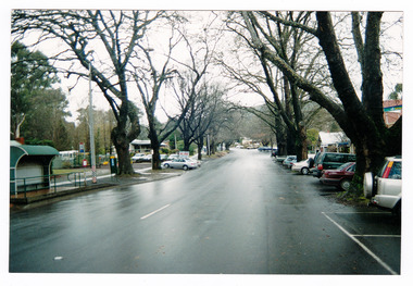
 Whitehorse Historical Society Inc.
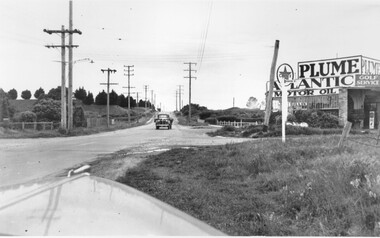
Photograph, Whitehorse Road, Mitcham - Service Road, 1/10/2000 12:00:00 AM
Coloured photograph of north Service Road in Whitehorse Road, Mitcham, looking west to shop and Service Station on the corner of Alexander Street Mitcham.service roads, whitehorse road mitcham, alexander street, mitcham -
Eltham District Historical Society Inc
Photograph, George W. Bell, Main Road, Eltham 1950's, 1950s
photograph of Main Road, Eltham, between Dudley and Arthur Streets. c.1950smain road, eltham, shops, george w bell collection -
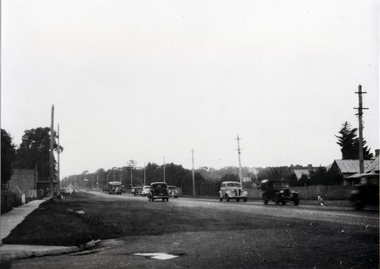
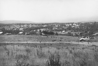 Ringwood and District Historical Society
Photograph, Looking east from Loughnan Road across William & Andrew Streets c.1946
... Streets c.1946. ...Looking east from Loughnan Road across William & Andrew Streets 1946 -
Port Melbourne Historical & Preservation Society
Ceremonial object - Foundation stone, Missions to Seamen, Port Melbourne, 1937
During demolition of the 1937 Missions to Seamen building in October 1995, this stone was removed intact by developers Mirvac Victoria, and placed in the care of the PMH&PS.Cornerstone laid at the Missions to Seamen building, Beach Road and Swallow Street, in 1937.Engraved in black lettering on a granite background: To the glory of God and the welfare of all seafarers this foundation stone was laid by His Excellency the Governor of Victoria, the Lord Huntingfield K.C.M.G. May 18th 1937. This branch Institute of the Victorian Missions to Seamen was erected through the generosity of Alfred M Nicholas Esq. Office of Harry A Norris Architectsmissions to seamen, harry a norris, lord huntingfield -
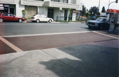 Whitehorse Historical Society Inc.
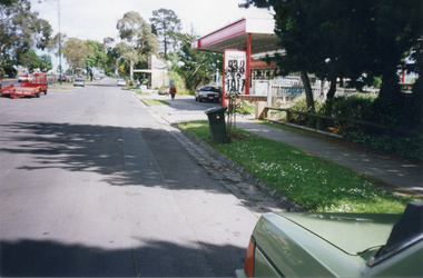
Photograph, Station Street, Mitcham, 1/10/2000 12:00:00 AM
Coloured photograph of South west corner of Station Street/ Whitehorse Road, Mitcham.station street, mitcham, whitehorse road -
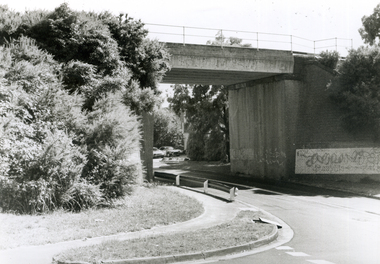 Whitehorse Historical Society Inc.
Photograph, Railway Bridge, 4/01/2001 12:00:00 AM
Black and white photograph of Railway Bridge, Cochrane Street and Brunswick Road, Mitcham.cochrane street, mitcham, brunswick road -
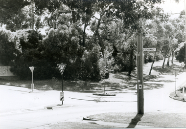 Whitehorse Historical Society Inc.
Photograph, Brunswick Road, Mitcham, 4/01/2001 12:00:00 AM
Black and white photograph of corner Brunswick Road and Cochrane Street, Mitcham.Looking West.brunswick road, mitcham, cochrane street -
 Whitehorse Historical Society Inc.
Photograph - Black and white photograph, Whitehorse Road at Chapel Street looking East, c1910
Used by donor in 'Blackburn - a picturesque history'Black & white photo showing Whitehorse Road at Chapel Street looking east.whitehorse road, blackburn, chapel street -
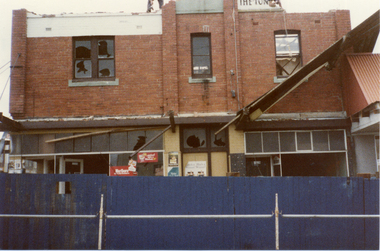 Whitehorse Historical Society Inc.
Photograph, Demolition Site, 1/11/1983 12:00:00 AM
Coloured photo of demolition site on corner of Station Street and Whitehorse Road Mitchamstation street mitcham, whitehorse road mitcham, demolition site -
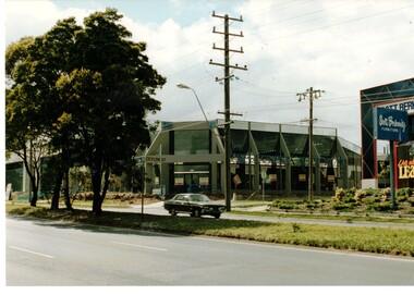 Whitehorse Historical Society Inc.
Photograph, Building Industry in Whitehorse
Grey building under construction on the corner of Whitehorse Road and Ceylon Street Nunawading.whitehorse road, ceylon street, nunawading, buildings -
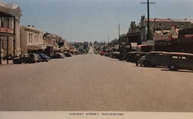 Ballarat Heritage Services
Photograph - Image from a Postcard Booklet Image, Vincent Street Daylesford, c1948
Daylesford in a tourist town with natural mineral water springsPhotographic image of a streetscape of Vincent Street Daylesford from Central Springs Roaddaylesford, central springs road, vincent street, streetscape -
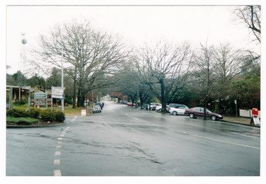
 Whitehorse Historical Society Inc.
Photograph, Whitehorse Road, Mitcham
Coloured photo of Whitehorse Road, Mitcham, west of Station Street. Taken 2003whitehorse road, mitcham -
University of Melbourne, Burnley Campus Archives
Photograph - Black and white print, 946/5, 30 March 1948
"30/3/48." Road to Plant Research laboratory from Swan Street.road, plant research laboratory, swan street, e. m. gibson collection -
University of Melbourne, Burnley Campus Archives
Photograph - Black and white print, 946/7, 30 March 1948
"30/3/48." Road to Plant Research Laboratory from Swan Street.road, plant research laboratory, swan street, e. m. gibson collection -
Canterbury History Group
Photograph - Street view of the Canterbury Post Office from Maling Road, Stuart Warmington, 1995
Coloured photograph of street view of the Canterbury Post Office from Maling Roadcanterbury, maling road, shops -
Canterbury History Group
Photograph - Street view of shop No.88 Maling Road in The Block 1907, Stuart Warmington, 1995
Coloured photograph of street view of shop No.88 Maling Road in The Block 1907canterbury, maling road, shops, the block 1907 -
Canterbury History Group
Photograph - Street view of shop No.86 Maling Road in The Block 1907, Stuart Warmington, 1995
Coloured photograph of Street view of shop No.86 Maling Road in The Block 1907canterbury, maling road, shops, the block 1907 -
Canterbury History Group
Photograph - Street view of 2 new shops in Maling Road , Canterbury, Stuart Warmington, 1995
Coloured photograph of street view of 2 new shops in Maling Road , Canterburycanterbury, maling road, shops -
Canterbury History Group
Photograph - Street view of 2 new shops in Maling Road , Canterbury, Stuart Warmington, 1995
Coloured photograph of street view of 2 new shops in Maling Road , Canterburycanterbury, maling road, shops -
Canterbury History Group
Photograph - Street view of 2 new shops in maling Road, Canterbury, Stuart Warmington, 1995
Coloured photograph of street view of 2 new shops in maling Road, Canterburycanterbury, maling road, shops -
Canterbury History Group
Photograph - Street view of 2 new shops in maling Road, Canterbury, Stuart Warmington, 1995
Coloured photograph of street view of 2 new shops in maling Road, Canterburycanterbury, maling road, shops