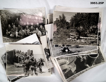
Showing 1485 items matching " staff photo"
-
 Lara RSL Sub Branch
Photograph - B and W photograph, Kit McNaughton and fellow staff of the plastic Surgery division of the Queen Mary Hospital, Sidcup, Kent, England 1918
Kit McNaughton and fellow staff of the plastic Surgery division of the Queen Mary Hospital, Sidcup, Kent, England 1918 Also the cover picture of the paperback book, "Kitty's War" by Janet Butler 2013On Back of Photo - WWW.Kit .Mcnaughton Reminiscences from a bloody Imperial War NSW Nurses and Midwives Association Janet Butler - 'Kitty's War' Latrobe University Queen Mary Hospital Sidcup in Kent England Plastic Surgery Hospital 1918unknown -
 Lara RSL Sub Branch
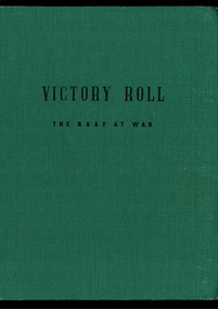
Book, Victory Roll - The RAAF at War, 1952
The stories in 'Victory Roll' tell of some of the deeds performed in the final and victorious year of WWII. They add to a long tradition of gallant service and sacrifice and will serve as an eternal inspiration in the task of building a new world in which the spirit of the Four Freedoms must predominate. In making final victory possible, we lost many comrades, to w home this book, together with those which preceded it, becomes a permanent memorial.Green hardcover and spine with black text - 'Victory Roll The RAAF at war' on front cover and spine. The inside front and back covers have silhouette, green sepia pictures of a variety of aeroplane. Illustrations, photographs and cartoonsMessage from the Chief of Air Staff.... Air Vice Marshal, Chief of Ai Staff C.Joneswwii, raaf, end of conflict, test pilot, wewak, the sisters fly on, battle of borneo, the biscuit bombers, anzacs on bougainville, raaf pacific, return to timor, pacific landing, long range from darwin, air victory over burma, lifeline to china, photo recce, first over malaya, jungle dawn, the victory in europe, story of a prison camp, night flight over hamburg, youth's prayer at a war memorial, victory at the alps, waaf's good service -
 Bendigo Military Museum
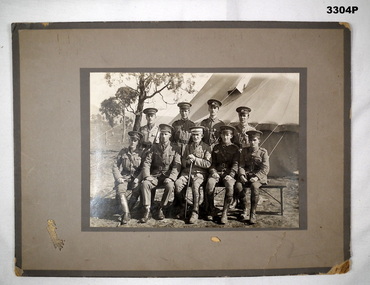
Photograph - PHOTOGRAPH, PRE WW1, Talma & Co, 1912 - 1914
Sepia photo mounted on grey cardboard backing. Shows 9 Officers in full uniform - 4 standing, 5 seated. There are no leggings on Officer 2nd from L, front row. Officer centre front has walking stick. Trees & tent in background.On back of photo: “1912 - 1914 Seymour Restoration Camp Staff” Names of Officers are listed along with name of donor.photographs, camp, restoration, pre war -
 Bendigo Military Museum
Photograph - PHOTOGRAPHS WW1 - WW2, 9) Col H T ALLAN, 1) 11.11.1918; .3) c.Jul-Aug 1940; .4) & .5) c.WWII; .6), .7) & .8) post WWII; .9) - .16) 29.3.1958;
Herbert Trangmar ALLAN, refer Cat No 2755.4 for his extensive service records and awards. .3) Taken during his appointment to Headquarters of the Command & Staff School, 2nd Military District. .7) Col H T ALLAN former commander of the Pacific Islands Regiment. .10) See newspaper articles 3046.52 & 3046.53 a., b., c. .11) - .14) See newspaper articles 3046.52 & 3046.53 a., b., c. .16) The flap staff was donated by the Royal Papua & New Guinea Constabulary. See newspaper articles 3046.52 & 3046.53 a., b., c. Th photos are of various sizes with an average as per the size field. .1) Black & white full length photo of Capt Herbert T ALLAN, 17th Battalion, in Australian Army uniform from WWI, location unknown. .2) Black & white studio portrait of Herbert T ALLAN in suit & tie. Photo is mounted on cream card with a khaki border. Photo is secured in a cream card folder. .3) Black & white photo of a group of Australian Army Officers in uniform. Front row seated, rear / middle rows standing. Herbert T ALLAN seated front row 2nd from right. Headquarters of Command & Staff School in background. .4) Black & white photo of a battalion of soldiers marching down a street with sloped rifles & fixed bayonets. Battalion led by an Officer most likely to be Herbert T ALLAN. Solder on horseback in foreground. Civilian observers line the street. .5) Black & white photo of an Australian Army Officer, most likely Herbert T ALLAN, standing in front of a tent in New Guinea. .6) Black & white photo of Col Herbert T ALLAN seated, taken in New Guinea. .7) Black & white photo of Col H T ALLAN talking to 3 New Guinea natives who are possibly former members of the Pacific Islands Regiment. .8) Black & white photo of Col H T ALLAN & his New Guinean driver in an Australian Base Command jeep. .9) Black & white photo of New Guinean spectators at the opening of the Rabaul Ex-Servicemen's Club. .10) Black & white photo of Col Herbert T ALLAN with a group of PNG Ex-Servicemen. All are wearing medals. To the immediate left of Col Herbert T ALLAN is Raymond Martin, Club President. On wall behind is a rifle donated by Capt R CLAMMER of Rabaul Police. .11) Black & white photo of a presentation table to the Rabaul Ex-Servicemen, by the New Britain Boy Scouts. Club President, Raymond Martin is receiving the table with Colonel Herbert T ALLAN looking on. .12) Black & white photo of Rabaul Ex-Servicemen's Club President, Raymond Martin making a speech at the Club's opening with Colonel Herbert T ALLAN, a Naval Officer & a group looking on. Group is in front of PNG Rabaul Branch of Native Ex-Servicemen's Association building. .13) Black & white photo of the parade of PNG Ex-Servicemen, Boy Scouts & spectators at the opening of the Rabaul Ex-Servicemen's Club. .14) Black & white photo of Colonel Herbert T ALLAN inspecting a parade of PNG Ex-Servicemen at the opening of the Rabaul Ex-Servicemen's Club. .15) Black & white photo of the official party at the opening of the Papua & New Guinea Rabaul Branch Native Ex-Servicemen's Club. .16) Black & white photo of Colonel Herbert T ALLAN raising the Australian flag in front of a parade of PNG Ex-Servicemen, Boy Scouts & spectators at the opening of the Rabaul Ex-Servicemen's Club. .1) Handwritten on back: Armistice Day Nov 11th 1918. Hence the smile. .2) Printed on folder front: Portrait study by Howard Harris. Handwritten on back: Blue Allan. .3) On front: Handwritten 'X' below H T ALLAN. On back: Stamp of S J Hood photographer detailing order No 1. .5) Handwritten in pencil on back: Return to I Marsh Woolgoolga. .6) Stamped in blue ink on back: Photograph No MH 75552 Supplied by Military History Section (SD?) General? LHQ For official purpose ONLY NOT TO BE PUBLISHED .7) Stamped in blue ink on back: Photograph No MH 75553 Supplied by Military History Section (SD?) General? LHQ For official purpose ONLY NOT TO BE PUBLISHED Handwritten in pencil on back: Return to I Marsh Woolgoolga. .8) Stamped in blue ink on back: Photograph No MH 75556 Supplied by Military History Section (SD?) General? LHQ For official purpose ONLY NOT TO BE PUBLISHED photographs, articles, pacific, new guinea -
 Bendigo Military Museum
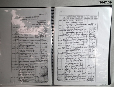
Administrative record - FOLDER AND RECORDS
For historical information refer to notes attached to Cat No 2755.4 See attached sheets for the remainder of pages.Black plastic folder, ring binding with 20 clear plastic sleeves. .1) Photocopy of cover for personnel documents for Herbert Trangmar ALLAN, MC, NX12229, N60005, Captain 2nd Garrison Battalion. A4 page size. .2) Photocopy of WWII attestation form dated 2.5.1940 for NX12229, Herbert Trangmar ALLAN. .3) Photocopy of Medical Exam Section. .4) Photocopy of Medical Exam Section with black & white ID photo. .5) Enlarged photocopy of ID photos of Herbert Trangmar ALLAN. .6) Photocopy of Mobilization attestation form dated 6.10.39 for Herbert Trangmar ALLAN. .7) Photocopy of Termination of Officer's Appointment dated 2.4.1946 for Herbert Trangmar ALLAN, OBE, NX12229. .8) Photocopy of Officers Record of Service for Herbert Trangmar ALLAN. Address at time was Wali, New Guinea .9) Photocopy of Officers Record of Suc for Herbert Trangmar ALLAN OBE MC ED NX12229. Address at time was Wali, New Guinea. First entry: 16.6.1914. Last entry: 1.11.1945. .10) Photocopy of Officers Record of Service, dated 29.8.1950. For NX12229 Herbert Trangmar ALLAN MC OBE ED. Last address Watsons Bay NSW. .11) Photocopy of Determination of Demobilization Priority for NX12229 Herbert Trangmar ALLAN. Dated 5.10.1945. .12) Photocopy of sheet showing service early WWII for Herbert Trangmar ALLAN. .13) Photocopy of sheet showing early WWII service of N60005, Herbert Trangmar ALLAN. .14) Photocopy of Officer's Record of Service sheet for Herbert Trangmar ALLAN OBE MC NX12229. First entry: 17/2/1943. Last entry: 24.8.1944. .15) Photocopy of Record of Service sheet. First entry: 28.9.1944. Last entry: 25.5.1945. .16) Photocopy of Officer's Record of Service for Herbert Trangmar ALLAN OBE MC NX12229. First entry: 1.6.1945. Last entry: 14.3.1946. .17) Photocopy of Record of Service sheet. Mentions MID in SWPA & rank changes. First entry: 21.3.1946. Last entry: 30.9.1950. .18) Photocopy of Officer's Record of Service sheet for NX12229 Herbert Trangmar ALLAN 2nd Garrison Battalion. First entry: 6.9.1944. Last entry: 7.5.1946 .19) Photocopy of Recommendation for an OBE for NX12229 Herbert Trangmar ALLAN MC Major. Tobruk period April / October 1941. .20) Photocopy of a sheet showing medals & awards for N60005 NX12229 Herbert Trangmar ALLAN OBE MC ED MID. .21) Photocopy of a letter to Deputy Commissioner - Repatriation on AIF letterhead. Re: Captain ALLAN H T 17 Battalion. .22) Photocopy of an AIF letterhead Canberra dated 1.5.1950. To Secretary HQ Repat Commission. Re: Capt ALLAN H T 17 Battalion. .23) Photocopy of a sheet showing telephone note re awards, dated 2.7.1955. Re: ALLAN H T. Address Mullaway, Woolgoolga, NSW. .24) Photocopy of ranks & dates for ALLAN H T NX12229. DOB 5.1.1895. Served in 14-18 Yes. First entry: 16.6.1914. Last entry: 29.1.1944. .25) Photocopy of ranks & dates for above. First entry: 13.2.1942. Last entry: 1.4.1945. .26) Photocopy of ranks & dates for ALLAN H T NX12229. DOB 5.1.1895. OBE MC. First entry: 23.7.1945. Last entry: 15.8.1951. .27) Photocopy of a note showing Colonel H T ALLAN, address Mullaway, Woolgoolga, NSW. Written on a note pad with British Aluminium stamped on it. .28) Typed sheet showing a brief (biography) story of the life of Herbert Trangmar ALLAN (Blue). .29) Colour top view photo on A4 paper showing a huge pair of Japanese binoculars mounted on a tripod. .30) Colour R side view photo on A4 paper of Japanese binoculars. .31) Colour rear view photo of huge Japanese binoculars. .32) Colour front view photo on A4 paper of huge Japanese binoculars mounted on a tripod. .33) Colour L side view photo of huge Japanese binoculars. .34) Colour photo of tripod with timber legs & brace to suit binoculars above. .35) Black & white photo of a manufacturers plate featuring Japanese writing & numbers. .36) Colour photo on A4 paper showing manufacturers plate on rear of support brace on the tripod head. .37) Copy of WM Collection photo number 058101 showing an Australian soldier looking into the binoculars, Finschafen New Guinea .38) Menu card. TobrukDay Dinner 2/17th Sgts Mess. Dated Wed 19.11.1941. .39) Christmas card with red ribbon in its fold. Shows a signpost Syria - Australia - & a Rising Sun, a kangaroo with smoke & fire, a laughing kookaburra on a sign post. Stamp. HQ 20 Aust Inf Bde AIF. .38) On rear: Two autographs. .39) Inside: “Best wishes for year 1942-1943 from Brig W (T) V Windeyer and staff”recorrds, certificcats, folders -
 Bendigo Military Museum
Administrative record - COMPENDIUM WW1 - WW2, 4) A H Pettifer, Government Printer et al, 2) 14.2.1946; .3) 1.3.1919; .4) 30.11.1954 .5) 24.11.19? - WWI; .6) 31.10.1917; .7) 12.6.1917; .8) Page 1: 20.12.1915, Page 2: 10.12.1915, Page 6: 19.1915; .9) 10.9.1918; .10) 18.4.1919; .11) c.2.3.19?; .12) 18.9.1920; .14) post WWI; .15) 24.4.1920; .17) 18.4.1942; .18) 19.6.1943; .19) 18.3.1947; .20) 1944; .21) 1944; .23) 22.10.1941; .26) 13.9.1944; .27) 1.1944; .30) 7.3.1950; .31) 31.7.1944; .32) 16.4.1942; .33) 13.6.1946; .34) 6.5.1946; .36) a) & b) 3.11.1947; .37) 24.10.1951; .38) 24.9.1957; .39) 9.10.1957; .40) 19.2.1958; .41) 26.2.1958; .42) 1.3.1958; .43) & .44) 7.3.1958; .45) 25.2.1958; .46) 3.1.1948; .47) 26.2.1948; .48) 22.4.1958; .49) 24.2.1958; .50) 12.3.1958; .51) 6.1958; .52) c.Mar/Apr 1958; .53) 5.4.1958; .54) c.end WWII; .55) a.b. 13.6.1967; .56) 26.5.1967; .57) 18.2.1954
Herbert Trangmar Allan, refer 2755.4 for his extensive service history and wards. .2) Details gifting of a pair of Japanese binoculars to Col H T ALLAN by Pacific Island Regiment. .3) Certificate issued by Winston Churchill, Secretary of State for War (The War of 1914-1918), awarded to Capt H T ALLAN MC. .4) Herbert Trangman ALLAN born 5.1.1895 at Woolwich, NSW. Middle name misspelled, should be Trangmar not Trangman. .6) Congratulating H T ALLAN on receiving the Military Cross award for leading 2 companies which had lost officers during action on Passchendaele Ridge on 9.10.1917. .7) Describes life behind the lines whilst H T ALLAN's battalion has been resting for a month. Daily life consisted of training drills, sport & entertainment. Writer takes time to describe the countryside & weather. .8) Relate to H T ALLAN's military exam results & his promotion to 2nd Lieutenant in 1915. .9) To Herbert Allan's father, Mr P Allan detailing the citation for awarding of the Military Cross to Herbert ALLAN. Original citation appeared in the London Gazette,5.4.1918. .10) Form addressed to Capt H ALLAN MC, 17th Battalion stating his period of enlistment in the 1st AIF was to expire 26.5.1919. .11) Letter from Lord BIRDWOOD (General) to Herbert ALLAN in response to a letter received 19.11.19?. General BIRDWOOD expresses his opinions on difficulties the allied troops face in their fight against the Japanese. .12) Letter to Capt H T ALLAN advising of MID oak leaves sent to him. Details guidelines for attaching oak leaves to both the larger Victory Medal & the small service dress medal. .13) Form details H T ALLAN's WWII Army No, Rank, Unit & Decorations & Medals held. The form has not been signed & dated. .14) Details service record of Lt Col H T ALLAN NX12229. Includes military service from 1912 - 1944, schools & courses attended, decorations, promotions & overseas service. .16) Form issued to H T ALLAN on 15.12.1939 granting permission to leave New Guinea for Australia & return within a period of 12 months. Issued by Customs Office in Salamaua. Lists H T ALLAN's age as 44, height 5' 10" & occupation. .17) Letter from Major General MORSHEAD GOC, AIF (ME) to Major H T ALLAN, OBE, MC congratulating him on being awarded the OBE for outstanding service at Tobruch. .18) Letter from Major General MORSHEAD to Major H T ALLAN, OBE, MC replying to ALLAN's letter of 15.6.1943. MORSHEAD is congratulating ALLAN on his appointment to New Guinea Force, also acknowledges his excellent service record. .19) Letter acknowledges H T ALLAN's resignation from the Office of Production Member of the Australian New Guinea Production Control Board, effective from 28.8.1946. .20) Major General WINDEYER commanded the 20th Brigade from 1942-1946. .22) Card sent from the CO of the 3rd Australian Anti-Tank Regiment. .23) Menu for Farewell Dinner held in the Officer's Mess of the 20th Infantry Brigade, Tobruch on 22.10.1941. .24) Menu & Toast list for Farewell Dinner to Brigadier J J MURRAY DSO MC VD. Attended by H T ALLAN & held in the Officers Mess, 2/17 Australian Infantry Battalion on 22.12.1941. .25) Invitation to Col H T ALLAN by Lady Gowrie (wife of Governor General Baron Gowrie) to attend a Luncheon at Government House, Canberra, ACT. .26) Letter to Major (T/Lt Col) H T ALLAN from Major W A JENNER advising him of his secondment to 2/17 Australian Infantry Battalion & appointment to command 5 Aust Base Sub Area. .27) Application for Africa Star with Eighth Army Clasp signed by H T ALLAN & approved by Lt Colonel of 2/17 Australian Infantry Battalion. H T ALLAN held the rank of Major (substantive) at the time of qualification, 1.3.1942 - 11.1942. He held the rank of Lt Colonel at the time of application in 2.1944. .28) Detailing changes in command & promotions including that of Lt Col H T ALLAN, dated 1.4.19? .29) For Lt Col H T ALLAN detailing movements required by First Australian Army command. .30) Acknowledgement & confirmation of Col H T ALLAN's application for campaign awards for WWII. .31) Letter addressed to Lt Col H T ALLAN from Lt Gen Stanley Sauige requesting information on New Britain for a forthcoming visit. .32) Certificate was presented to H T ALLAN on 16.4.1942 when he was awarded an OBE by King George VI. .33) Document details H T ALLAN's relinguishing of Command of the HQ of Pacific Islands Regiment. ALLAN also relinguished the rank of temporary Colonel & was transferred to the Reserve of Officers with rank of substantive Lt Colonel. .35) Official letter to Colonel H T ALLAN from Joseph Francis, Minister for the Army. The letter acknowledges Col ALLAN's long & distinguished career during both peace & wartime. .36) a) & b) From H T ALLAN (assumed) to Prime Minister J B CHIFFLEY referring to the production of copra in New Guinea, the actions of the Commonwealth Bank in relation to planters & the collaboration of New Guinea natives with the Japanese. Assumed to be a copy of original. .37) Letter to H T ALLAN indicating he had been placed on the Retired List with the rank of Honorary Colonel. .38) Letter invites H T ALLAN to officially open the State Conference in Lae in late March or early April 1958. Invitation was extended due to H T ALLAN for distinguished service in PNG. .39) Letter to H T ALLAN thanking him for accepting the invitation to open the Papua & New Guinea State Conference in late March or early April 1958. .40) Letter from H T ALLAN to Lt Gen Sir Henry WELLS, Chief of the General Staff, Victoria Barracks, Melbourne. ALLAN requests permission to wear his uniform for official engagements during his upcoming visit to New Guinea. ALLAN also offers advice on how to deal with native troops including serving time with them, learning their language & studying their customs. He suggests that this would help quell & dissent & revolt. .41) Reply from Major General DALY to HT ALLAN thanking him for his offer to spend time with the CO of the Pacific Island Regiment to address concerns with that unit. This meeting would coincide with ALLAN's upcoming visit to PNG. .42) HT ALLAN's reply to Major General T J DALY's letter of 26.2.1958. ALLAN requests an opportunity to discuss PIR issues with Major General DALY prior to his visit to PNG. .43) Major General T J DALY's reply to HT ALLAN's request for a meeting to discuss ongoing issues with the Pacific Island Regiment. .44) Letter from HT ALLAN to Brigadier D M CLELAND notifying him that he will be staying in Port Moresby on his way to the RSS&AILA Congress in Lae. .45) Lieutenant Colonel MCGUINN writes to invite Colonel ALLAN to visit the PIR during his visit to New Guinea at the end of March of the beginning of April 1959. .46) Letter of appreciation to H T ALLAN thanking him for his efforts in presenting the case for the Territory of New Guinea during the post WWII transition period. .47) Letter to H T ALLAN from New Guinea Citizens Association, Lae Branch, thanking him for his service on behalf of the people of the Territory of New Guinea. The association offered to send ALLAN a suitable present in recognition of his service. .48) Major General T J DALY's reply to HT ALLAN's suggestions for handling disquiet amongst the native troops in the Pacific Island Regiment. .49) Reply from Lieutenant General WELLS to H T ALLAN granting him permission to wear his uniform on his forthcoming visit to New Guinea. WELLS also notes that he has passed other requests made by ALLAN to Major General DALY. .50) Copy of H T ALLAN's reply to Lieutenant General WELL's letter of 24.2.1958 [.49)]. .51) A written account of Colonel H T Blue ALLAN's visit to New Guinea in 3.1958. Article appeared on p.65 & 67 of the 6.1958 edition of Pacific Islands Monthly. .52) Newspaper account of Colonel H T Blue ALLAN's opening of the Rabaul Branch of the Native Ex Servicemen's Association. Colonel ALLAN spoke of the involvement of the Pacific Islands Regiment during WWII. .53) The Rabaul Times account of Colonel H T Blue ALLAN's opening of the Rabaul Branch of Native Ex Servicemen's Club. Featured on p1, concluded p3. .54) Biographical account of Colonel H T ALLAN's service in WWI & WWII. In addition an account of his success in New Guinea between the wars is included. .55) a.b. Biography of Colonel H T ALLAN written by R W Robson who was the founder of the Pacific Islands Monthly. Article was written following ALLAN's death on 23.5.1967 aged 72. This item is a pre publication copy of Robson's article which appeared in the Pacific Islands Monthly. .56) Text of a valedictory given at the funeral of Colonel Herbert Trangmar ALLAN OBE, MC, ED, NX12229 held 26.5.1967 following his death on 23.5.1967. The speech summarized his life in both wars & civilian life. 57) Invitation issued to Colonel H T & Mrs ALLAN to attend a Garden Party at Government House on 18.2.1954. At this function Colonel H T & Mrs ALLAN were to be presented to her Majesty Queen Elizabeth II.Herbert T ALLAN Collection. The contents are all of various size, the Album is the size documented. .1) Large teal green album containing 16 plastic pockets each with white card insert. Various documents & photos contained in each pocket. .2) Typed letter, black type on cream paper. .3) Certificate mounted on fawn card backed with dark brown veneer. Presented to Capt H T ALLAN MC for being mentioned in despatches on 7.11.1917. .4) New South Wales Birth Certificate extract, printed on pink paper with watermark. .5) Telegram on tissue paper to a sheet of cream paper. Pin located top L corner. Requests the attendance of Lt Herbert ALLAN, Russell Hotel, Russell Square. .6) Typed letter mounted on grey cardboard. .7) 2 page letter on foolscap paper, secured by pin top L corner. Written from France by Herbert (Bert) ALLAN & addressed to his father. .8) 11 pages secured with a clip top L corner. 1st document typed, 2nd handwritten, remainder printed. Relate to H T ALLAN's military exam results. .9) Typed letter from Department of Defence Base Records Office to P ALLAN. .10) Document, printed form to inform the recipient that their period of enlistment in the 1st AIF had expired. .11) 4 page handwritten letter on 2 sheets of paper. 1st page has a printed letterhead. .12) BR Form No 20. Typed formal letter from AIF Base Records Office to accompany Mentioned in Despatches oak leaves sent to the recipient. .13) Form AAFA36 used for recommending the awarding of an Efficiency Decoration. Form details service record & details of a serving soldier. .14) 1 large / 1 small page, numbered, detailing the service record of Lt Col H T ALLAN. Black type on cream paper. 2 pages are loose but evidence of attachment visible. .15) Bachelor of Arts Degree Certificate (testamur) granted by the University of Sydney, awarded to Herbert Trangmar ALLAN. Printed on cream parchment. .16) Proforma document issued by the Territory of New Guinea permitting leave & return to the Territory. Printed 2 sides, black type on cream paper. .17) Letter on Australian Imperial Force letterhead from Major General MORSHEAD to Major H T ALLAN. .18 Letter on HQ2 Aust Corps letterhead from Major General MORSHEAD to Major H T ALLAN. .19) Typed letter on External Territories letterhead from J R Halligan to H T ALLAN. .20) Cream Christmas card folded in 2, sent to H T ALLAN. On front in black lettering is HQ 20th Australian Infantry Brigade below black Rising Sun emblem. Inside in black lettering is With Best Wishes for Christmas and New Year. Christmas 1944. .21) Cream card folded in 2. Front illustration depicts a devil figure riding a platypus & carrying a pennant with 2/13 on it. The devil is depicted attacking a German & Japanese soldier. Below the devil is a boomerang with Greetings Xmas 1944 printed on it. Illustration is in green & black. Inside on LHS is a message from 2/13 Battalion. On RHS is a list of 2/13 battle honours from 1940-1943. On back in black print is 1944-1945 New Guinea Australia. .22) Cream Christmas card folded in 2. Front illustration in brown with word Greetings in green. RHS inside printing in green & brown letters. Artillery badge on back in brown. .23) Cream card folded in 2. Typed menu on cream paper attached inside. Front cover illustrated with 20th Infantry Brigade colour patch & a rat over a scroll with words - So What? .24) Cream card folded in 2. On front black printing accompanied by 2/17 Battalion colour patch that is black over green diamond shape. Inside a list of Toasts & Dinner Menu printed in black. Back page for autographs. .25) Cream invitation card. Black cursive script printing below gold crown on front. .26) Typed letter on cream paper. .27) Typed foolscap application form to claim the Africa Star. .28) & .29) Message form filled with typed orders. .30) Typed letter acknowledging an application for campaign medals & listing eligible awards. .31) Typed letter on bond paper. .32) Certificate on cream parchment. Black print in cursive script. Text details the awarding of an OBE to the recipient. .33) Typed text on Australian Military Forces letterhead. Cream paper. .34) Typed text. Temporary note for H T ALLAN's discharge from AMF. .35) Typed letter on Commonwealth of Australia, Minister for the Army letterhead. .36) a) & b) 2 page letter in black type on cream paper. Pages are loose, letter unsigned. .37) 1 page typed letter on Australian Military Forces letterhead. .38) & .39) 1 page typed letter on Return Sailors, Soldiers & Airmen's Imperial League of Australia, Papua & New Guinea Branch letterhead. .40) 1 page typed letter, unsigned. .41) Single sided typed letter on Australian Military Forces letterhead on cream paper. .42) 1 page typed letter, unsigned on cream paper. .43) Single sided typed letter on Australian Military Forces, Northern Command, Victoria Barracks, Brisbane letterhead on cream paper. .44) Single sided typed letter on cream paper. .45) 2 page typed letter on folded cream paper bearing the letterhead of the Pacific Islands Regiment. .46) 1 page typed letter on cream, lined paper. .47) 1 page typed letter on cream paper. .48) 1 page typed letter on Australian Military Forces, Northern Command Headquarters, Victoria Barracks, Brisbane letterhead on cream paper. .49) 1 page typed letter on Chief of General Staff, Australian Military Forces, Army Headquarters, Victoria Barracks, Melbourne letterhead on cream paper. .50) 1 page copy of an unsigned letter on cream paper. .51) Magazine article: Building a New Nation in New Guinea : Some advice from Colonel Blue ALLAN. Black & white article with a 2nd small section stapled to the main page. Large page features a black & white captioned photo of a group listening to a uniformed Officer deliver a speech. Also features advertising front & back. .52) Newspaper article: Official Opening of Native Ex Servicemen's Club. Black & white typed newspaper article featuring a captioned black & white photo of a uniformed Australian Officer & a group of New Guinea Ex Servicemen. .53) a. b. c. Newspaper article: Master Blue Came Back to the Islands: 4000 Attend Club Opening. 3 Section article cut from a newspaper. One part is the banner of the newspaper with date published. Other sections contain the text of the article. The larger section features a black & white photo of an Australian Army Officer in uniform. .54) Newspaper article, untitled. Black & white typed newspaper article with black & white caricature of an Australian Army Officer featured. .55) a. b. Magazine article: The Story of a Big Man who Loved Soldiering. 2 page black & white typed article with sub headings. .56) Text of a Speech. 2 page typed text written for a valedictory given at a funeral. Pages connected with a staple in the top L corner. .57) Printed, cream card invitation to a Garden Party for the recipient to meet Queen Elizabeth II & The Duke of Edinburgh. Text is in cursive script under the Coat of Arms of Her Majesty. .2) Signature ? Capt S C PIR. .4) Date of issue typed: 30.11.1954 Name of recipient: Herbert Trangman Allan Stamped: T Wells, Registrar General NSW .5) Handwritten: To Lt Herbert Allan, Russell Hotel, Russell Square. Typed: Buckingham Palace OHS. Your attendance is required at Buckingham Palace on Wednesday next the Twentyeighth inst (28.11.19?) at ten o'clock am service dress please telegraph acknowledgement Lord Chamberlain London. Stamped: Central District 24 NO 19. .6) Signed in pencil: W Birdwood. In pencil on back: 15 x 12. .8) p1: Handwritten signature. Copy dated 29.12.1915. p2 Handwritten in ink: P Allan Esq, Mount Hunter Hill. Military Examination. Copy dated 29.12.1915. Handwritten in pencil: Results: H T Allan. Tactics - Distinction 92% HE Barff p3 Underlined in ink: 38th Infantry Herbert Trangmar Allan to be 2nd Lieutenant (provisionally). Dated 16 June 1914. p5 Handwritten: Total 139. Lieut Allan tied with 15 others for 20 place. p7, 9, 10 & 11underlined in ink: H T Allan. p8 Underlined in ink: Allan HT. .9) & .10) Signature in black ink. .12) Handwritten signature in black ink: On back handwritten signature in black ink: Clive Wilkinson, Buddong, Robinson St, Chatswood. Also ? Rd, Cremorne Pt. .13) Handwritten in black ink: Details of HT Allan's Commission Service from 16.6.1914 - 18.2.1946. .15) Handwritten signature of the University Chancellor, Dean of Faculty of Arts & Registrar. Handwritten name of recipient. Seal of the University of Sydney imprinted bottom LHS. .16) Handwritten in black ink: Details of recipient. Stamped in red ink: New Guinea Customs. Stamped in blue ink: H M Customs, Cooktown, dated 17.12.1939. Handwritten on reverse: Signature. Stamped on reverse in red ink: New Guinea Customs, dated 15.12.1939. .17) & .18) Handwritten signature: Major General Morshead. .19) Handwritten signature in black ink: J R Halligan. .20) Handwritten inside in blue ink: Lt Col Allan. Good wishes from your many friends here. Signed by Major General Windeyer. .21) Inside LHS handwritten in blue ink: Lt Col Allan & an indecipherable signature. .22) Inside RHS handwritten: To Major (Blue) Allan OBE MC from Lt Col? .23) On front handwritten in blue ink: H T Allan?. Inside in black ink & pencil are 19 signatures. .24) On front: 3 signatures in black ink & pencil. On back: 36 signatures in black & blue ink & pencil. .25) On back handwritten in black ink: Colonel H T Allan OBE MC, with 3 ink lines below name. .26) Handwritten in blue/black ink: Signature. Handwritten in blue pencil top R corner: A32/3477. Handwritten in black ink bottom L corner: Cond (?) 15/9A. Handwritten in black ink: Signature. .27) Stamped top R corner: 2/17 Bn Received 9.2.1944. Signature in black ink: H T Allan. Signature in black ink: ? Lt Col 2/17 Aust Inf Bn 10.2.1944 Page bottom in pencil: Blue will keep 1 1/4 for you? .30) Handwritten: Details of eligible medals. Handwritten signature: J C K Miller Capt 7.3.50. Handwritten bottom L corner: Col H T Allan Bottom R corner: OBE, MC, 1914-19, Victory, ED, MID 1914-18, MID 1939-45 On back: Steak & Kidney Morris ) Clark ) Vowood ) 10/- 70215 Maughan ) Allan ) .31) Top of page: Imprinted Coat of Arms Top LHS in black ink: TOP SECRET AND PERSONAL Handwritten signature: Stanley Sauige .32) Embossed top L corner: Seal of the Most Excellent Order of the British Empire. Handwritten: Mary R. .32) Signed: Queen Mary, mother of George VI. .33) Handwritten signature. .34) Handwritten in blue ink: HERBERT TRANGMAR ALLAN 6 MAY 46 Handwritten signature. .35) Handwritten signature in blue ink: Joseph Francis, Minister for the Army. .37) Handwritten signature. .38) & .39) Handwritten signature: J W Knight. .41), .43) & .45) Handwritten signature in blue ink. .46) & .47) Handwritten signature in black ink: Henry G Eckhoff. .48) Handwritten signature in blue ink: With best wishes Yours sincerely T J Daly. .49) Handwritten signature in black ink: Yours sincerely H Wells. .57) Handwritten in black ink: Colonel & Mrs H T Allan.certificates, records, awards, administrative, compendium -
 Bendigo Military Museum
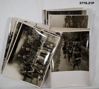
Photograph - PHOTOGRAPHS, MILITARY, 1960’s - 1990’s
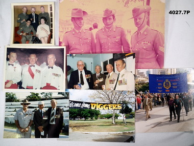
All photos relate to the collection of "Francis William (Dinky) DEAN" BEM VX93960 2nd AIF, 3742 1 RAR 1943 - 1975. Refer Cat No 124.2 for his service history. (.1) The soldier on the left standing is Frank Dean. The soldier sitting is wearing a “DCM” being Bruno Flematti No 54679 1 RAR, awarded the DCM over 4 actions in Vietnam 1968/69. On the rear stamped in purple “Nov.69.H” (.2) The soldier centre is Bruno Flematti, soldier on the right is Frank Dean. (.3) Soldier centres is Frank Dean. On the rear in black pen “The terrific trio”. (.4) The man on the left is possibly Max (Dad) Kelly, centre is Frank Dean, the man on the right also appears to be wearing a BEM. (.5) Frank Dean is 2nd from the right, the man on the left also appears to be wearing a BEM. (.7) On the rear in black pen “1999” All photos are in colour. (.1) Group of 5 people, 3 standing, 2 sitting, 3 are in uniform, 1 man and 1 female and a dog. (.2) Group of 3 soldiers, 2 Sgt’s and 1 Staff Sgt. (.3) Group of 3 soldiers in Mess Dress. (.4) Three men in civilian clothes wearing medals, 2 wearing hats. (.5) Four men in civilian clothes wearing medals. (.6) Barracks scene across gardens with large banner “Welcome home Diggers”. (.7) Parade showing a large banner with details of 1 RAR’s service and Battle Honours. photography, military, reunions, francis william dean -
 Bendigo Military Museum
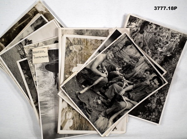
Photograph - PHOTOGRAPHS WW2, Dept of Information, Military History Section SD9, General Staff LHQ, c.1942 - 1944
Collection of Frank Herbert HORN QX16945, 7th Division Portal Unit, who served in Middle East & South Pacific.Sepia / black / white photos taken 1942-1944 in Papua New Guinea.photographs, new guinea -
 Bendigo Military Museum
Photograph - PHOTOGRAPHS WW2, 1945
.1) R J LEE MM is in the rear row 3rd from right. The photos are in the collection of R J LEE MM, VX65555. Ref Cat No 1734 for his service details. .1) - .25) Series of photos revolving around landing at Bougainville Island, setting up an artillery base & fire missions. Photos are black / white. All are individually stamped with a number on rear.On rear of all stamped in purple. “Photograph No MH. Supplied by Military History Section (SD9) General Staff LHQ. For personel enjoyment only and on condition that it will not be reproduced in any form”photographs, bouganville -
 Bendigo Military Museum
Album - ALBUM, PHOTOGRAPH, Army printing and stationary services, Third Battle of the Somme 1918, C.1918
A collection of photographs of the third battle of the Somme 1918 put out by the General Staff (Intelligence) Australian Corps..1) Album hard cover, brown coloured with library fabric on spine, black print on cover, 26 pages, sepia tone glossy photos bound into album, within album where 4 loose pages as below. .2) photograph and map sepia colour folded. .3)photograph, colour of “General Sir William Riddell Birdwood”. .4 ) .5) Monochrome prints of buildings on paper..4) .5) Handwritten in grey lead pencil, “ VG Sladden”albums, military history, the somme photography -
 Bendigo Military Museum
Photograph - PHOTOGRAPHS WW2, c.1943 - 1945
Photos in possession of Captain Alan COOKE VX124263, 148 General Transport Company. Enlisted 13.3.1943.Black / white photos of military funeral, Northern Territory 1943 - 1945.photographs, funeral, nt -
 Bendigo Military Museum
Album - ALBUM WW2, PHOTOGRAPH, 1942 - 1945
Collection of Frank Herbert HORN QX16945, 7th Division Postal Unit. Area of Service, Middle East & South Pacific.Blue cardboard covered photo album containing 30 photos taken during WWII in Gona, Papua New Guinea.album, photographs -
 Bendigo Military Museum
Photograph - PHOTOGRAPHS WW2, Dept of Information, Military History, Section SD9, General Staff LHQ, 1941 - 45
Collection of Balikpopan, Borneo WWII photos of Frank Herbert HORN QX16945, 7th Division Postal Unit.Sepia photos in South Pacific, Balikpapan, Borneo.photographs, pacific, islands -
 Bendigo Military Museum
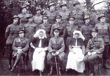
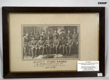
Photograph - PHOTOGRAPH WW1, FRAMED, c.1917
... photo of officers & staff.... to 2nd Lieut. H. B. Field by Officers & Staff of Area 67B ...H.B. Field, refer Cat No 890P for his service details.Wooden frame, cream border, glass fronted, sepia group photo of officers & staff.Botton centre: “Presented to 2nd Lieut. H. B. Field by Officers & Staff of Area 67B. On the occasion of his enlisting in the AIF July 5th 1917”.passchendaele barracks trust, 67th bn, framed -
 Federation University Historical Collection
Photograph - Photograph - black and white, Rubie Lonie
Ruby Lonie was Senior Clerk of the Ballarat School of Mines (SMB) Administrative Staff. Always known as Miss Lonie, her sole position was at SMB where she worked between May 1914 and May 1960. When the SMB Registrar, John Robinson, died in 1935 the question of who would fill the position became a matter of urgency. The temporary answer was Miss Lonie, who was the senior clerk on the Registrar's staff. The permanent position was looked upon as an exclusively male preserve. At Miss Lonie's retirement function SMB President, M.B. John, noted that Miss Lonie had joined the staff in 1914 and had 'done a tremendous job since that time, and for many years had been the Registrar's "Right Hand Man". Twenty Four years after having acted as Registrar the current SMB Registrar, F.F.Ferguson recognised Miss Lonie's assistance and her extensive knowledge of the history and the administrative procedures of the School. He added 'I have noted on many occasions Miss Lonie's kindly interest in people in times of sickness or difficulty and her willingness to help.' Current and former staff members were keen to acknowledge Miss Lonie. Former Principal Dick Richards said 'That Miss Lonie had been in this one job all her life is a great tribute to the school, and the Council is conscious of her devoted service.' The Principal, Mr Arblaster, on behalf of himself and the staff presented Miss Lonie with a gold watch and wished her well in her retirement. The next day Miss Lonie, along with Hestor Darby, the SMB Typewriting teacher who was on long service leave, sailed from Melbourne for London, mainly to visit Scotland.A black and white photo of a woman, Ruby Lonieruby lonie, ballarat school of mines, women, university women -
 Federation University Historical Collection
Photograph, Retirement Function, c1984
... Photos of a staff function in the Mt Helen Union Building... brian coles geoff biddington meena biddington Photos of a staff ...Photos of a staff function in the Mt Helen Union Building. Possibly a staff retirement function.buildings, mount helen campus, union building, u building, e.j. barker, jack barker, phil day, robert pyke, aziz albazzaz, shirley coles, brian coles, geoff biddington, meena biddington -
 Bendigo Military Museum
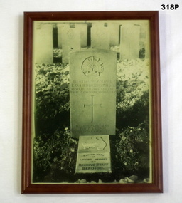
Photograph - PHOTOGRAPH, FRAMED, Post 1918
Robert Oswald HENDERSON had previous service in the Militia dating from 1899 with the 67th Battalion. He enlisted in the AIF with the rank of Major as 2IC in the 38th Bn on 1.5.1916 at the age of 41 years. Embarked for England 20.6.1916, embark for France 22.11.1916, promoted to Lt Col to command the 39th Bn 15.2.1917, hospital 17.9.1917 with Defective vision, appears to a have rejoined his unit same day, WIA 29.3.1918 GSW to left thumb, rejoin unit 13.6.1918, KIA 29.9.1918 near Bony on the Hindenburg Line. Buried by the Rev W.A.Moore on 1.10.1918. He was awarded the DSO 18.1.1918 and Mentioned in Despatches 25.5.1918. The Beehive Store was a major Department Store in Pall Mall Bendigo.Photo of the Australian War Grave in France of Lt Col. R O HENDERSON DSO 39Bn. KIA. Headstone reads "Placed here in Loving Memory by/ BEEHIVE STAFF Bendigo". Message written on back of photo states he was buried at St Emilie, a town about 6 miles N E of Perrone.On back of Frame "Photo Mrs J H Henderson" photos, graves, framed, ww1 -
 Bendigo Military Museum
Film - PHOTOGRAPH, 1917
Fanny Isabella Nicol from Rochester enlisted as a Staff Nurse A.A.N.S reinforcements AIF age 30 years on 11.7.17. Embarked 31.8.17 and disembarked in Alexandria and served there and in Abassia. She served in the 17th, 31st, 71st General Hospitals and the 14th Aust General hospital. She was discharged from the AIF on 13.6.19. Refer 1797.5,1796.9, 2317.6, 2591.B&W copy of a photo re Fanny Isabella Nicol in uniform.on rear of photo is 1/25medicine - nursing, photograph - photography -
 Bendigo Military Museum
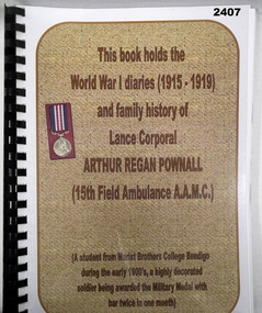
Literary work - DIARY, TRANSCRIPT, Frank Pownall, A R POWNALL'S SON, Post 2000
Arthur Reagan POWNALL No 5345 enlisted in the AIF on 16.6.1915 in reinforcements for Convalescent Depot in London age 23 years 7 months. Embark for England 22.7.1915, promoted L/Cpl 6.10.1916, embark for France 5.3.1917, transfer to 5th Div AMC 23.3.1917, transfer to 15th Field Ambulance 25.3.1917, WIA 8.5.1917 GSW’s to legs, rejoin unit 26.6.17, awarded the Military Medal (MM) near Perrone 2.9.18 as a stretcher bearer, awarded a bar to the Military Medal 29/30.9.1918 over 36 hours as a stretcher bearer at Bellicourt, hospital 24.10.1918 accidental injury bayonet wound left thigh, embark for Australia transport duty as N/Staff Masseur 19.4.1919, discharged from the AIF 23.9.1919. A bar to the Military Medal means he has actually won two MM’s. Plastic covered folder with black binding containing typed diary of A R POWNALL 22.7.15 to 9.6.19, 120 pages. Also copies of Service Records, Awards. The rear has folded sheets with photostats of photos & newspaper articles.documents - diaries - transcripts, military history -
 Bendigo Military Museum
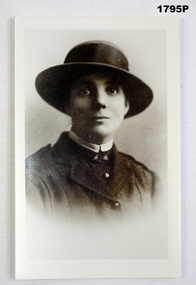
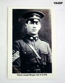
Photograph - PHOTOGRAPH WW1, Original Approx 1916 - 1917
Patrick Joseph Morgan was a big man for the times at 6 foot 3 and a half inches. He had 5 years service prior to enlisting in the AIF on Instructional Staff in 16th Light Horse with the rank of A/Staff Sgt. He enlisted in the AIF in 9th reinforcements B Coy 58th Batt with the rank of Sgt 16.2.1917 age 23 years 7 months. Embark for England 16.7.1917, embark for France 4.12.17, attend Musketry School 22.5.1918 - 30.6.1918, KIA 31.8.1918.B/W copy of original photo for display of Patrick Joseph Morgan in uniform wearing peak cap, Sam Brown, on sleeve 4 stripes. “Patrick Joseph Morgan K.I.A 31/8/1918”photography- photographs, morgan -
 Federation University Historical Collection
Book - Catalogue, ADGD, Advanced Diploma of Graphic Design, Graduate Book, 2011, 2011
Page 4 features list of 13 graduates of the University of Ballarat Advanced Diploma of Graphic Design (2 years). Introduction by Paul Mah (co-ordinator / teacher). Teaching staff listed: Sam Harmer, James Baker, Selena Shillito, Travis Price, Jill Hyatt, Ben Sanders, Anthony Woodward, Alister Heighway, Peter Lambert, Paul Mah. Cover design by Kylie Findlay (student). Student work featured throughout along with student names, photos and contact details. 32pp + 4pp cover saddle-stitched booklet. Full colour cover, gloss varnish pattern, gold foil. Full colour offset pages. Promotional catalogue for graduating students of the University of Ballarat (TAFE), Advanced Diploma of Graphic Design, 2011. 32-page + 4-page cover saddle-stitched booklet. Full colour cover, gloss varnish pattern, gold foil. Full colour offset pages.university of ballarat, federation university, graphic design, tafe, advanced diploma, arts academy, camp street campus -
Federation University Historical Collection
Booklet - Booklet - Prospectus, McCarron, Bird and Co. Printers, Collins Street, Melbourne Junior Technical School, Prospectus,1914, 1915
Used at Ballarat School of Mines and Industries. The Melbourne Junior Technical School opened in 1912. It was a School for Junior Technical Work in Science, Art and Trade.` Information about aim of school, constitution, council, day courses, scholarships, holidays, evening courses, regulations, rules, sports, staff, students and syllabus.Light green covered booklet with gold crest with photo of The Melbourne Junior Technical School. 56 pages. Information about aim of school, constitution, council, day courses, scholarships, holidays, evening courses, regulations, rules, sports, staff, students and syllabus. melbourne, melbourne junior technical school, prospectus, john lemmon, t.j. greenway, d. avery, a.w. craig, c. gray, c.a. hack, wilfrid.n. kernot, a.h. merrin, h. payne, w.c. scurry, p. mccormack, principal, councillors, staff, trades, w bruce, head of department, r hudspeth, c greehill, j russell, r kinross, c juncken, a b lundy, a dunstan, mathematics, e j lewis, d j morris, english, g m nicholas, m samuel, science, r a white, j e jones, art, w gilmore, e thompson, physical culture, a j hauser, w d wilson -
Federation University Historical Collection
Book - Book - Scrapbook, Ballarat School of MInes: Scrapbook of Newspaper Cuttings, Book 19, October 1983 to February 1984
Collection of newspaper articles related to Ballarat School Of Mines.They cover activities and advertisements for staff. The papers concerned are The Courier, Ballarat, The Australian, The Age over the period of 20 October 1983 to 25 February 1984.Book with yellow cover, front, spiral bound. courses available, teaching positions advertised, nick morris wins photo competition, ross armstrong's photo, douglas miller to play in melbourne concert, ballarat teachers join strike, smb to cut programs, adult literacy course at smb, visitors from indonesia, selkirk brick pty ltd, farm apprenticeships, smb art instructor neville bunning, smb vocational skills centre, exhibition sums up lives of colquhouns, amalie colquhourn, neville bunning still painting at 81, lauren pointon smb wins organ scholarship, former smb students honored, philip tjerkstra, edward sperber, peter manzel, traditional end for classes, karina martin - modern greek classes, $670000 grant for school, first woman completes building construction course at smb - nerida smith, more continue studies in hope of jobs, twelve learn first skills - fitting and machining, art prize has local links, hugh williamson- art benefactor, woolclassing courses at smb cut, louise kellett wins photographic prize -
Federation University Historical Collection
Book - Book - Scrapbook, Ballarat School of MInes: Scrapbook of Newspaper Cuttings, Book 33, October 1987 to January 1988
Collection of newspaper articles related to Ballarat School Of Mines.They cover activities and advertisements for staff. The papers concerned are The Courier, Ballarat, The Australian, The Age over the period of 22 July to 3 October 1987.Book with green cover, front, spiral bound. teaching positions advertised, pre-employment courses, courses available, indonesian school chiefs visit, dana street safety issue, appeal to help radio station relocate, inskill program enables cost savings, tiffany parker second in hair colouring competition, trish bishop and averil macklin, booklet 'wednesday's words, better deal for small business, how to speak without words, gift of toys to smb creche, jenny leviston, photograph display at smb, historical photo query, counselling skills graduation, aboriginal women students, play tunnel designed by women's trade and technical program, 100-year-old book returns to ballarat, wither's history of ballarat volume one, lower aim beats stress, dr bob montgomery, tertiary orientation program art show, smb will 'sell' courses to new apprentices, competition between tafe colleges, sovereign hill cottages to be opened, metal trades course begins, cfa unit prepared by smb students, nance jeffries gold medalist, drake international world veteran games melbourne, geoffrey mainwaring painter of portrait, barker portrait to college council, gail snowden, memories of early schoolong, peter mansfield, numbers drop for training courses -
 Bendigo Military Museum
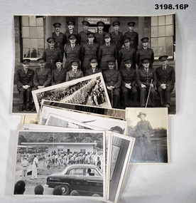
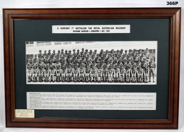
Photograph - PHOTOGRAPH - FRAMED, Framed photograph of 'A Company 1st Battalion The Royal Australian Regiment/Selarang Garrison - Singapore - Oct 1970', 1970
The photo relates to Francis William (Dinky) Dean BEM, VX93960 2nd AIF, 3742 1 RAR. Refer Cat No 124.2 for his service details. Framed photograph of 'A Company 1st Battalion The Royal Australian Regiment/Selarang Garrison - Singapore - Oct 1970' Staff Photograph. Photograph: Group black and white photograph of soldiers in uniform. Printed information (row position and names) provided below photograph. Frame: timber with decorative edge, mid brown colour stain, glass front. Mount: dark green coloured cardboard.Printed label above photograph: "A Company 1st Battalion The Royal Australian Regiment/Selarang Garrison - Singapore - Oct 1970" Bottom left on glass, printed label in black ink. "FRANK (DINKY) DEAN BEM/ Front row 7 from right/ donated by/ Mrs M Dean/ Refer book 54" photography, military, accessories, history, army -
 Conservation Volunteers
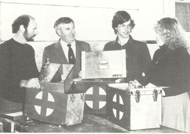
Memorabilia: First Aid Boxes - safety has always been a top priority at Conservation Volunteers
... Made by students and staff at the School of Mines Ballarat... goldfields Made by students and staff at the School of Mines Ballarat ...Made by students and staff at the School of Mines Ballarat in 1983 and donated to the then fledgling ATCV. Photo attached shows staff Robert Brouwers and Gayle Spicer accepting the donation.........The boxes have been in the safe keeping of Terry Peacock at the Adelaide CVA office.....terry recalls that the only injury treated using the box he recalls was when the box slammed forward when the bus stopped abruptly and hit his head...Basic safety was important from the very first projects. ATCV/CVA later developed a formidable safety culture.Wooden boxes for storage and transport of First Aid materials on ATCV/CVA tasks/projects.Grey cross in white circle on sideof, school, ballarat, peacock, mines, safety, first, aid, terry -
 Wycheproof & District Historical Society Inc.
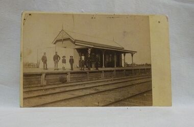
Sepia photo, Photographer unknown, Historic Wycheproof Railway Station, 1904 (estimated)
This railway station building was erected in 1887 and closed in 1990. Now a new chapter begins with a newly restored station building amd platform that re-opened in October 2010 to be used by the Wycheproof Community.The Wycheproof Railway station constructed by Hossack & Brown in 1887 is Heritage listed and is on the Government Buildings Register. This photo is one of only a few available of the early days of the Station.The complex is historically significant at a State level AHC A.4. The Railway station contains significant detailing such as in the turned timber posts and overall composition. This early photo of Wycheproof railway station, shows a construction of timber with corrugated iron clad roof,in c.1904. Features of the design are the timber verandah posts with decorative elements which include chamfers and supporting diagonal timber brackets. The gabled roof has finials on the east and west ends. Seven people pose on the platform,the staff in uniform of the times.Nilregister, , railways, wycheproof, historic buildings, 1900s -
 Greensborough Historical Society
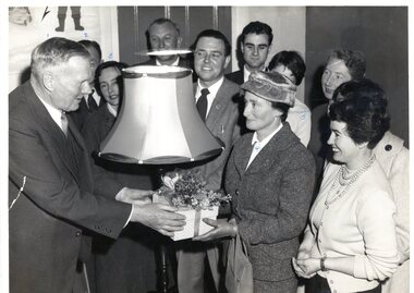
Photograph, The Age, Presentation to Mr J. G. Cannon 1958, 08/08/1958
Photograph of Presentation to Mr J. G. Cannon, Assistant Chief Inspector of Special Schools 1958. Also named on back of photo are: Mr Griffiths H.T. (Head Teacher) SS4431 Children's Cottages; Miss Roffe H.T. SS4679 Croxton Special; Miss Richards H.T. Janefield Special ; Miss Trewhella SS2784 Montague Special. Taken on Friday 8/8/1958.Black and white photographCaption on back: "Presentation to Mr J. G. Cannon 1958..."janefield, janefield special school, janefield staff -
 Greensborough Historical Society
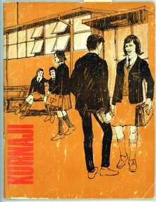
Magazine - School Magazine, Watsonia High School, Kurnaji 1967 Watsonia High School Yearbook WaHIGH, 1967_
A permanent record of who attended Watsonia High School - both student and teacher in 1967 - includes photographs and articles on school activities. The donor of this copy, Glynne Cousins Pietzsch was a member of the magazine committee for this edition.Annual record of teaching staff, students and events that took place over the year by using both photos and reports.68 Pages, orange cover, Title "Kurnaji" in black ink. Cover illustration - black ink line drawing of students in school grounds. Letter to Glynne Pietszch pasted inside front cover.watsonia high school, yearbook, kurnaji, school magazines, glynne pietzsch, glynne cousins pietzsch -
 Greensborough Historical Society
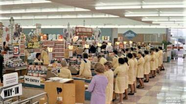
Photograph - Digital Image, Coles New World Greensborough, late 1960s, 1960s
Colour photograph of Coles New World interior with staff at every checkout. It appears to be taken soon after the supermarket was opened (see banner in centre of photo "New World Opening". This store was located in Main Street Greensborough. Digital copy of colour photographcoles new world greensborough, main street greensborough, supermarket