Showing 7054 items matching " station street"
-
 Port Melbourne Historical & Preservation Society
Photograph - Station Hotel, corner Bridge and Station Streets, Port Melbourne, c. 1950
... . Hall Station Station Streets'..., Excelsior Hall later R.S.S. Hall Station Station Streets' Black ...Black & white photograph of the Station Hotel looking down onto Railway Reserve & Excelsior Hall.On reverse ' Station Hotel, Excelsior Hall later R.S.S. Hall Station Station Streets'business and traders - hotels, built environment - commercial, built environment - domestic, station hotel, excelsior hall -
 Ringwood and District Historical Society
Envelope, Packet: Greenwood Sub-division (plans, 1924 notes etc)
... "Greenwood" subdivision, Greenwood Avenue & Station Street..., Greenwood Avenue & Station Street 22 pages plus several ..."Greenwood" subdivision, Greenwood Avenue & Station Street 22 pages plus several subdivisional plans. -
 Whitehorse Historical Society Inc.
Photograph, Mitcham Railway Station, 1/10/2000 12:00:00 AM
... Station taken from Station Street corner.... of north side of Mitcham Railway Station taken from Station Street ...Coloured photograph of north side of Mitcham Railway Station taken from Station Street corner.mitcham railway station -
 Whitehorse Historical Society Inc.
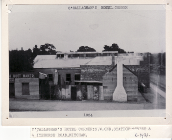
Photograph, Hill Hotel
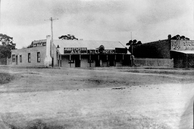
... Black and white Photo of Hill Hotel, S.W. corner of Station... and white Photo of Hill Hotel, S.W. corner of Station Street ...Black and white Photo of Hill Hotel, S.W. corner of Station Street and Whitehorse Road, Mitcham.hill hotel, mitcham, o'callaghan's hotel -
 Whitehorse Historical Society Inc.
Photograph - Coloured Photograph, Whitehorse Road Blackburn, 2/08/1979 12:00:00 AM
... Coloured photo of Whitehorse Road and Station Street corner... of Whitehorse Road and Station Street corner, from Blackburn overpass ...Coloured photo of Whitehorse Road and Station Street corner, from Blackburn overpass looking Eastwhitehorse road, blackburn -
 Whitehorse Historical Society Inc.
Photograph - Black and white photograph, Mitcham Post Office 1924, C1924
... Whitehorse Road and Station Street, Mitcham... Post Office, corner Whitehorse Road and Station Street, Mitcham ...Black and white photo of Mitcham Post Office, corner Whitehorse Road and Station Street, Mitchampost office, mitcham, 1924 -
 Whitehorse Historical Society Inc.
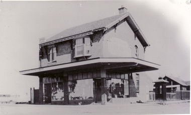
Photograph - B/W Photograph, O'Callaghan's Pub Corner, C1924
... Station Street and Whitehorse Road, Mitcham. ... of O'Callaghan's Pub Corner, cnr Station Street and Whitehorse Road ...O'Callaghan's hotel was one of three 'hotels' which operated in Mitcham in the late 19th century. Suited on the corner of Station St and Whitehorse Road it was run by Irish widow, Mary Jane O'Callaghan. She died in 1916 and the hotel was de-licensed in 1917 and this photo was taken shortly before the building was demolished in 1924.Black and white photo of O'Callaghan's Pub Corner, cnr Station Street and Whitehorse Road, Mitcham. Large photograph filed in 2Eo'callaghan, mary, o'callaghan pub corner -
 Kew Historical Society Inc
Plan - Subdivision Plan, Jas R Mathers Son & McMillan, Eastlawn Estate : East Kew Auction Sale, 1914
... station street, normanby road, high street, woodlands... faced High, Station and Wright Streets, Harp and Normanby Roads.... subdivision plans - kew station street, normanby road, high street ...The Kew Historical Society's map collection includes a substantial number of real estate subdivision plans, mainly of Kew but also of surrounding suburbs in Melbourne. Most of the subdivision plans date from the 1920s and 1930s when the districts old homes and local farmland were being split up to accommodate residential growth in the postwar period. These early plans were assembled by a local firm, Jas R Mather & McMillan, which had an office in Cotham Road. Many of the plans, and sometimes photos, were annotated by the agents.Subdivision plans are historically important documents used as evidence for the growth of suburbs in Australia. They frequently provide information about when the land was sold as well as evidence relating to surveyors and real estate and financial agents. The numerous subdivision plans in the Kew Historical Society's collection represent working documents, ranging from the initial sketches made in planning a subdivision to printed plans on which auctioneers or agents listed the prices for which individual lots were sold. In a number of cases, the reverse of a subdivision plan in the collection includes a photograph of a house that was also for sale by the agent. These photographs provide significant heritage information relating house design and decoration, fencing and household gardens.The photograph may also be aesthetically significant depending on the importance of the photographic atelier.The ‘Eastlawn Estate’ was surveyed and ready for auction in March 1914, three months before the outbreak of World War I. Sixty-six allotments, created on the ‘order of Mr & Miss Preston’ surrounded the mansion of Woodlands in Harp Road. Woodlands formed part of the Estate, being advertised as lot 1. The allotments faced High, Station and Wright Streets, Harp and Normanby Roads, and Woodlands Avenue. Pru Sanderson in the Kew Conservation Study (Vol.2, 1988) wrote that the Eastlawn Estate ‘covered the western half of the failed Harp of Erin Estate’. Contemporary advertisements promoted the Eastlawn Estate as: ‘There will be no more convenient district nor pleasant Suburb than East Kew for the busy business man. When the Electric Tram is laid, he will be able to journey quickly and pleasantly direct from Collins Street to his home in the Eastlawn Estate in about 20 minutes’. The actual plans of subdivision were included in advertisements in The Argus and in the local newspapers."C" top left. Various annotations.subdivision plans - kew, station street, normanby road, high street, woodlands avenue, harp road, woodlands - kew -
 Melbourne Tram Museum
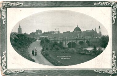
Postcard, Marlborough Art Series, Princes Bridge Melbourne, 1910
... Flinders Street station... Street station building. Note the clock on the right hand side... crossing. In the background is the then new Flinders Street station ...Photograph of Princes bridge Melbourne with one cable tram set crossing. In the background is the then new Flinders Street station building. Note the clock on the right hand side of the photograph that was later transferred to Spencer Street station. Yields information about Princes Bridge in 1910.postcard - decorative border with a photo of Princes Bridge within an oval - embossed. On the rear is a letter dated 21/12/1910. Card by Marlborough Art Series.See note on rear.tramways, trams, yarra river, princes bridge, cable trams, flinders street station, clocks -
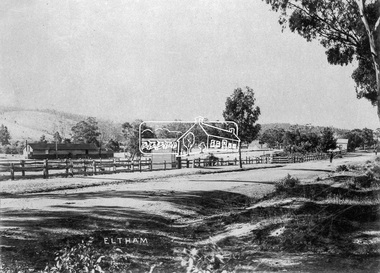
 Eltham District Historical Society Inc
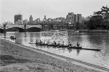
Photograph, George Coop, A day in Melbourne, November 1962, 1962
... Flinders Street Station, Melbourne, Princes Bridge, Rowing...Princes Bridge, Flinders Street Station in background.... melbourne Princes Bridge, Flinders Street Station in background ...Princes Bridge, Flinders Street Station in background.Digital TIFF file Scan of 35mm Ilford FP3 black and white transparencyflinders street station, melbourne, princes bridge, rowing, swanston street, yarra river -
 Port Melbourne Historical & Preservation Society
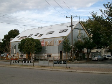
Photograph - Excelsior Hall, from corner Bridge and Station Streets, Port Melbourne, Glen Stuart, 25 May 2004
... Hall"). Taken from corner of Bridge and Station Streets.... and Station Streets. Photograph Excelsior Hall, from corner Bridge ...Colour photo of redevelopment of Excelsior Hall ("Diggers Hall"). Taken from corner of Bridge and Station Streets.built environment - civic, built environment, public housing, excelsior hall, rsl, returned services league -
 Greensborough Historical Society
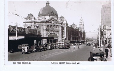
Postcard, Flinders Street Melbourne, 1930s
... flinders street station...Flinders Street Melbourne, facing west, Flinders Street... west, Flinders Street Station to the south. Rose Series ...Flinders Street Melbourne, facing west, Flinders Street Station to the south.Rose Series postcardBlack and white photograph, correspondence and address spaces on reverseRose Series P. 210melbourne, flinders street melbourne, flinders street station -
 City of Moorabbin Historical Society (Operating the Box Cottage Museum)
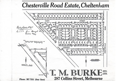
Flyer - Chesterville Road Estate, Cheltenham, 1947
... Station Street... Station Street Dawn Street Hubbard Street Chesterville Road ...Chesterville Road Estate, consisting of 101 building lots, was sold by private sale in late 1947.Example of the progress of the Municipality of MoorabbinPhotocopy of advertising flyer for sale of real estate sales - plan of building blocks for saleChesterville Road Estate, Cheltenham - plan of subdivisiontennyson street, port street, dennis street, station street, dawn street, hubbard street, chesterville road, cheltenham, real estate, auction -
Port Melbourne Historical & Preservation Society
Photograph - North Sandridge, 1870s
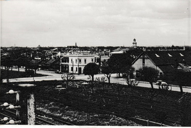
... station street... street station place "P. Anderson" ink, on back. North Sandridge ...One of a set of prints given by Syd Anderson (Town Clerk 1920-59) to his daughter-in-law Phyllis (donor). Photos in the set were exhibited in 1873 at the Melbourne Exhibition.North Sandridge/North Port station in the 1870s with footpath across railway reserve, Station Place in background. Hotel appears to be Lord Raglan Family Hotel"P. Anderson" ink, on back.transport - railways, built environment, sydney sims anderson, town clerks, station street, station place -
 Greensborough Historical Society
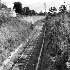
Photograph - Digital Image, Rail cutting approaching Greensborough Station 1970, 1970_
... Station. Looking toward Church Street, with Watson's car yard... approaching Greensborough Station. Looking toward Church Street ...Photograph of the rail cutting approaching Greensborough Station. Looking toward Church Street, with Watson's car yard on the left. Photo taken when widening cutting.Digital copy of black and white photograph. trains, greensborough railway station, church street greensborough -
Port Melbourne Historical & Preservation Society
Photograph - Port Melbourne Council horse and cart, Railway Reserve, 1920
... Town Council No. 3' on railway reservation, Station Street... Town Council No. 3' on railway reservation, Station Street ...Photo of council horse and (water?) cart 'Port Melbourne Town Council No. 3' on railway reservation, Station Street in background'Raglan St?' on backparks and gardens, local government - city of port melbourne -
 Hume City Civic Collection
Photograph, c1897
... A photo of "Priorswood" situated in Station Street, Sunbury... A photo of "Priorswood" situated in Station Street, Sunbury ...The original photo is part of an album taken by W.Walls, the front page of which is inscribed "The Hill / Sunbury / April 1897". Whilst most of the photos relate to the environs of the asylum, there are others taken around Sunbury and elsewhere. The original album is held as part of the Mental health Library collection. During 2000 this was transfered from Mont Park to the Royal Melbourne Hospital.A photo of "Priorswood" situated in Station Street, Sunbury. it was built as a vicarage for St. Mary's Church of England. Unmounted black and whitewalls, w., "priorswood" - house, st. mary's church of england, walls album, george evans collection -
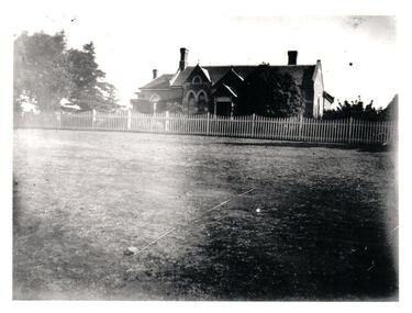
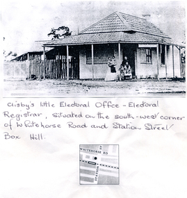 Whitehorse Historical Society Inc.
Photograph, Clisby's Electoral Office
... on South-West corner of Whitehorse Road and Station Street, Box... of Whitehorse Road and Station Street, Box Hill. Clisby's Electoral ...Clisby's Electoral Office - Electoral Registrar. Situated on South-West corner of Whitehorse Road and Station Street, Box Hill.clisby, electoral officers -
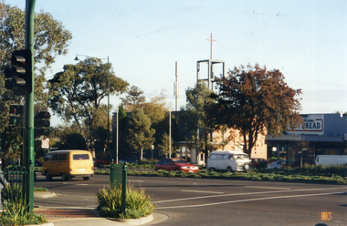 Whitehorse Historical Society Inc.
Photograph, Whitehorse Road, Mitcham
... and Station Street looking north-west toward the Anglican Church... of the corner of Whitehorse Road and Station Street looking north-west ...Coloured photograph of the corner of Whitehorse Road and Station Street looking north-west toward the Anglican Church, taken 2003whitehorse road, mitcham -
 Melbourne Tram Museum
Postcard - Nu-color-Vue - Flinders St Station - W2 637, Nucolorvue Publishing
... Flinders Street station...Postcard - image of Flinders Street Railway Station... Postcard - image of Flinders Street Railway Station, corner ...Postcard - image of Flinders Street Railway Station, corner of Swanston Street with W2 637 (Spencer St, route 48), possibly late 1970s or early 1980s. Tram W6 978 is in Swanston Street.Demonstrates an iconic Melbourne image, Flinders Street Station and a W class tramPostcard colour - Flinders St Station - Nu-color-vue card number 11 ML 138, NCV 4986 Divided back.trams, tramways, flinders street station, w2 class tram, tram 637, swanston street -
 Eltham District Historical Society Inc
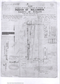
Survey Fleld Notes of Part of Crown Portion 13, Section 4 at Eltham, Parish of Nillumbik, County of Evelyn, 17 May 1926
... Portion of land bounded by: Eltham Railway Station, Main... Arthur Street Eltham Eltham Railway Station Luck Street Main Road ...Portion of land bounded by: Eltham Railway Station, Main Road, Luck Street, Arthur Street Application 4182/215 J.T. Robinson, Licensed Surveyor, 17 May 1926application 4182/215, arthur street, eltham, eltham railway station, luck street, main road, map, survey plan -
 Eltham District Historical Society Inc
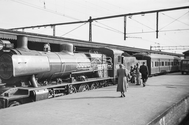
Photograph, George Coop, Steam locomotive N-430 and the Victorian Centenary Jubilee train at Spencer Street Railway Station, Feb. 1951
... train at Spencer Street Railway Station... at Spencer Street Railway Station Photograph Photograph George Coop ...The Centenary-Jubilee Train. The Centenary-Jubilee train was one of the outstanding successes of the Centenary and Jubilee celebrations in Victoria. The train, attractively painted green and gold, consisted of eleven cars, and toured Victoria to take to people in the country exhibits of interest associated with the celebrations. National Art Gallery paintings, rare manuscripts and pictures were displayed, as well as models showing the history of gold production, and models and illustrations of national projects controlled by the various departments of this State. The Commonwealth section included displays by the Army, Navy, Air Force and Post Office; a war materials exhibit from the Supply Department; and diagrams and maps of the Snowy Mountains Hydro-Electric scheme. The Railways exhibit portrayed the century's growth and development of railways in Victoria and their influence on the prosperity of the State. During its 6,000 miles tour, from 1st February to 30th June, the train visited 168 stations and was inspected by 547,978 people. An entertainment unit accompanied the train and gave 100 performances which were attended by 96,400 people. Source: Report of The Victorian Railways Commissioners for the Year Ended 30th June 1951Digital TIFF file Scan of Kopdak 620 black and white negative transparencygeorge coop collection, n-430, n-class steam locomotive, victorian centenary jubilee 1951 -
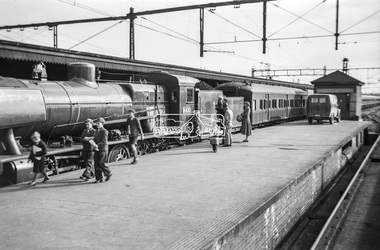 Eltham District Historical Society Inc
Photograph, George Coop, Steam locomotive N-430 and the Victorian Centenary Jubilee train at Spencer Street Railway Station, Feb. 1951
... train at Spencer Street Railway Station... at Spencer Street Railway Station Photograph Photograph George Coop ...The Centenary-Jubilee Train. The Centenary-Jubilee train was one of the outstanding successes of the Centenary and Jubilee celebrations in Victoria. The train, attractively painted green and gold, consisted of eleven cars, and toured Victoria to take to people in the country exhibits of interest associated with the celebrations. National Art Gallery paintings, rare manuscripts and pictures were displayed, as well as models showing the history of gold production, and models and illustrations of national projects controlled by the various departments of this State. The Commonwealth section included displays by the Army, Navy, Air Force and Post Office; a war materials exhibit from the Supply Department; and diagrams and maps of the Snowy Mountains Hydro-Electric scheme. The Railways exhibit portrayed the century's growth and development of railways in Victoria and their influence on the prosperity of the State. During its 6,000 miles tour, from 1st February to 30th June, the train visited 168 stations and was inspected by 547,978 people. An entertainment unit accompanied the train and gave 100 performances which were attended by 96,400 people. Source: Report of The Victorian Railways Commissioners for the Year Ended 30th June 1951Digital TIFF file Scan of Kopdak 620 black and white negative transparencygeorge coop collection, n-430, n-class steam locomotive, victorian centenary jubilee 1951 -
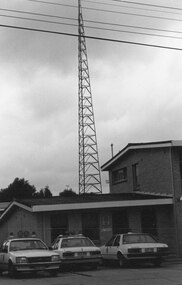
 Greensborough Historical Society
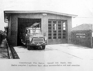
Photograph - Digital image, Church Street Fire Station, 15/05/1963
... Church Street Fire Station... of black and white photograph. Church Street Fire Station ...Opening of Fire Station in 1963. Greensborough had a fire service from 1938. It was relocated to Church Street in 1963 then moved to Grimshaw Street when Greensborough Plaza was developed.Digital copy of black and white photograph.greensborough fire station -
 Eltham District Historical Society Inc
Photograph, J.H. Clark, Eltham, Main Road from Arthur Street towards station
... Eltham, Main Road from Arthur Street towards station....View of Main Road, Eltham from Arthur Street towards... melbourne View of Main Road, Eltham from Arthur Street towards ...View of Main Road, Eltham from Arthur Street towards the railway station which can be seen on the left. Cross Ref: 609 (opposite direction) Photographer: J.H. Clark John Henry Clark was the youngest of three boys born to William Henry Clark (1823-1877) and Maria White (1843-1914). He and his brothers, William Charles Clark (1872-1945), Clement Kent Clark (1874-1912) operated a photography business (Clark Bros.) from 25 Thomas Street, Windsor near Prahran during the period c.1894 to 1914. Following death of Clement in September 1912 and their mother in 1914, the Clark Bros business appears to have dissolved, the premises demolished, and a new house was under construction in 1915. John set up business independently in 1914 operating out of 29 Moor Street, Fitzroy where he is registered in the 1914 and 1915 Electoral Rolls. By 1916 John had relocated to Eltham where he continued his practice as a photographer and took many of the early images around the district of Little Eltham. Around 1930 John changed professions and opened a small cobbler's shop in 1931 near the pond opposite Dalton Street adjacent to the Jarrold family cottage. He never married and continued his profession as a bootmaker from this little shop, maintaining a close relationship with Mrs Jarrold for the rest of their lives. His bootmaker shop remains today beside the Whitecloud cottage and is one of only three remaining shops in the area from the early 20th century. There are a couple of images of Eltham taken by Clark Bros. in the Eltham District Historical Society collection, one such example being Hunniford’s Post Office with Miss Anne Hunniford out front (EDHS_00140 - marked on the back of the print, Clark Bros., 25 Thomas St. Windsor), which would date this image between c.1894 and 1914. Other early images of Eltham taken by John Henry Clark are marked on the face “J. H. Clark Photo” and it is assumed these are dated between 1914 and 1930. It is noted that the Grant of Probate for John H Clark of Eltham South dated 5 April !957 (513/387) records his occupation as "X Photographer".\This photo forms part of a collection of photographs gathered by the Shire of Eltham for their centenary project book,"Pioneers and Painters: 100 years of the Shire of Eltham" by Alan Marshall (1971). The collection of over 500 images is held in partnership between Eltham District Historical Society and Yarra Plenty Regional Library (Eltham Library) and is now formally known as 'The Shire of Eltham Pioneers Photograph Collection.' It is significant in being the first community sourced collection representing the places and people of the Shire's first one hundred years.Digital imagesepp, shire of eltham pioneers photograph collection, eltham, main road, railway station, eltham railway station, j.h. clark photo -
 Eltham District Historical Society Inc
Photograph, Tom Prior, Police Station and Residence, Maria Street, Eltham, c.1900
... Police Station and Residence, Maria Street, Eltham... and Police station on Main Road and corner of Brougham Street ...Situated near the top of what was known as 'Policeman's Hill' according to Miss Ivy Reynolds, neice of the photographer, Tom Prior. From the left, Eltham Court House, Police Residence and Police station on Main Road and corner of Brougham Street. These buildings formed part of Little Eltham and still stand (without the front fence) today though the Police Station was demolished in 1986 due to termite damage. A replica was built circa 1989. The institutions of law and order in Colonial Victoria included the police, courts and prisons. The 1852 report of the Snodgrass Select Committee appointed to "identify the policing needs of the colony” noted there existed seven independent police forces that did not co-operate or regularly communicate. Following the committee's report all these police entities were merged into the Victoria Police, founded on 8 January 1853, to implement law and order responsibilities throughout the Colony of Victoria. The Eltham Courthouse (1860) and adjacent Police Residence (1859) formed a justice precinct established in the immediate aftermath of the 1852 police inquiry and the effects of the gold rush. The physical presence of these buildings, in the centre of the early Eltham township, defined centralised control over law and order. In the early days the Police Constable in charge would conduct his duties travelling around the district by horse; a stable was located at the rear of the residence. At times the horse would be grazed on the paddocks across the road. Horseshoes were forged by the blacksmith beside the Courthouse on the high side of “Policeman’s Hill”. Along with the stable, there was a two-cell bluestone lockup where prisoners were held awaiting trial in the adjacent Courthouse. Their meals were usually provided by the policeman’s wife or from the hotel just up the road. With the arrival of the railway in 1902 the town centre gradually shifted towards the railway station. The Police Station and operations were moved into the town centre in 1961 to a renovated house in Pryor Street, which was later replaced by the current Police Station. From 1961-1981 the residence was occupied by the Vermin and Noxious Weeds Destruction Section of the Department of Crown Lands and Survey. Prior to August 1967 the former Police Station was dragged to the rear of Police Residence to make way for the construction of a driveway and access from Main Road. The building was placed on the site of a former Scullery and modified for Lands Department use. In 1981 the Shire of Eltham took over management of the former Police Residence in Eltham. It remained unoccupied for a period whilst its future was discussed in Council. It was then used for a community job creation scheme until 1985. In 1985 the Shire of Eltham Parks and Environment occupied the residence. Council improved the driveway but later added a second rear access from Brougham Street due to the dangerous nature of the Main Road entrance. Additionally, a rear toilet facility between the Police Residence and the relocated former Police Station, which was doubling up as a lunchroom. Council also commenced discussions to re-establish a replica Police Station. Around November 1986 the former Police Station was demolished; believed to have been suffering termite damage. About 1989, after some years of discussion, a replica Police Station was built, based on photographs, to act as a lunchroom and meeting room for the Parks and Environment staff and volunteers doing community service. In 1996 Eltham District Historical Society held discussions with Nillumbik Shire Council commissioners throughout the year regarding a home for the Society. A proposal was put forward by the Society in October to occupy the former Police Residence. In March 1997 Eltham District Historical Society gained access to former Police Residence and on July 12, 1998, moved into its Local History Centre. In July 2018, Eltham District Historical Society gained access to the replica Police Station (which had been used as a music library and storage for the Eltham Concert Band) for use as part of regular heritage tours for schools and community-based groups.This photo forms part of a collection of photographs gathered by the Shire of Eltham for their centenary project book,"Pioneers and Painters: 100 years of the Shire of Eltham" by Alan Marshall (1971). The collection of over 500 images is held in partnership between Eltham District Historical Society and Yarra Plenty Regional Library (Eltham Library) and is now formally known as 'The Shire of Eltham Pioneers Photograph Collection.' It is significant in being the first community sourced collection representing the places and people of the Shire's first one hundred years. The Reynolds family were early settlers in Research. The Reynolds/ Prior collection of photographs were taken by Tom Prior, the maternal uncle of Ivy Reynolds, around 1900 and the 60 photos in the album give a fine overview of many of the landmarks of Research and Eltham over 100 years ago. lvy lived in the family home for many years at 106 Thompson Cres Research. Ivy's father, Ernst Richard Reynolds and grandfather, Richard Reynolds, lived at the same address. Ivy's father Richard worked for Mr. Trail on his property in Research. Reynolds Road is named after the family. Mr Tom Prior (wife Eva) worked at the Melbourne zoo. He was very innovative and made his own camera, using the black cloth hood to exclude the light. The photographs are a reminder of the rural nature of Research and Eltham and its rich heritage.Digital imagechildren, court house, courthouse, eltham, eltham district historical society, eltham justice precinct, little eltham, local history centre, main road, police residence, police station, reynolds prior collection, sepp, shadow, shire of eltham pioneers photograph collection -
 Ringwood and District Historical Society
Photograph, Ringwood Street Police Station, Ringwood 1982
... Ringwood Street Police Station, Ringwood 1982..., 1982. Ringwood Street". Ringwood Street Police Station ...Catalogue card reads, "Ringwood, 1982. Ringwood Street". -
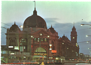 Melbourne Tram Museum
Postcard, John Sands - Sandscene International, "Flinders Street Railway Station", 1970
... "Flinders Street Railway Station"... with a serrated edge - No. JSC316 "Flinders Street Railway Station ...The photo shows the Flinders St station building at dusk. An MMTB bus and tram are waiting at the traffic lights. Tram fitted with marker lights shows a route number of "29" - which was discontinued in Nov. 1970. Marker lights commenced to be installed in 1970.Yields information about Flinders St station in about 1970.Colour postcard by Sandscene International, No. V7 with a serrated edge - No. JSC316postcards, route 29, flinders st station, flinders st, swanston street -
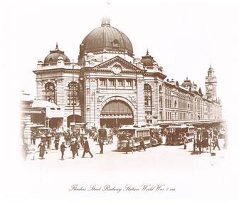 Melbourne Tram Museum
Photograph - Black & White Photograph/s, "Flinders Street Railway Station, World War 1 Era", 1980's?
... "Flinders Street Railway Station, World War 1 Era"... 1883 for a 1944 photograph. "Flinders Street Railway Station ...Reproduced photograph, sepia toned of "Flinders St Railway Station, World War 1 Era, taken from St Paul's Cathedral steps. Has part of the Princes Bridge Station building on the left hand side. The Swanston St canopy of Flinders St station has the words "Enlist and Fight for the Dear Old Flag". Two Richmond line cable trams in Flinders St along with horse drawn vehicles. One of a series of four photographs produced by an unknown person/company. Two sizes of prints held, one large, two small. See also Reg Item 1883 for a 1944 photograph.On the rear of 587 "Cable Tram prints $10/set"trams, tramways, melbourne, flinders st station, world war 1, cable trams -
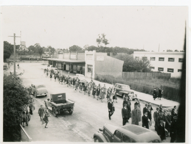 Whitehorse Historical Society Inc.
Photograph, Anzac Day, c1948
... at Anzac Day march. Looking south along station street, Mitcham... at Anzac Day march. Looking south along station street, Mitcham ...Black and white photo of Girl Guides and Returned Soldiers at Anzac Day march. Looking south along station street, Mitchamguide groups, exservice organisations, anzac day