Showing 288 items
matching stones corner
-
 Kilmore Historical Society
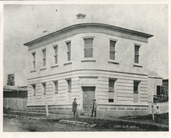
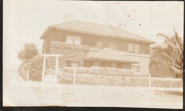
Photograph, 1 Powlett Street, 1867
Original image was published in the book "Kilmore on Sydney Road"8x10 black and white photograph of 1 Powlett street, former colonial bank of Australasia. corner of Powlett Street and Lancefield Road Copy printed on standard photographic paper Two story light coloured rendered building with blue stone street curbing. Two figures standing outside the door with a third to the right. Picket fence to left and right of building. Printed on the back REPRODUCTIONS RIGHTS RESERVED Copied by State Library of Victoria KOSR - 5 ("Kilmore on the Sydney Road", Chapter 1, Pg.5)powlett street, lancefield road, colonial bank of australasia, 1867, kilmore, bank, the court house hotel, hotel, kilmore on the sydney road -
 Kilmore Historical Society
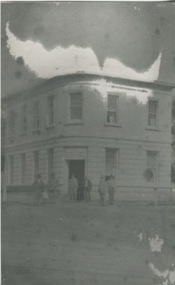
Photograph, Colonial Bank of Australasia, 1883
Donated by Dan Clancy. 1 Powlett Street, Kilmore, Mitchell Shire , Victoria, Australia10cm x 20cm black and white photograph of 1 Powlett street, former colonial bank of Australasia. Corner of Powlett Street and Lancefield Road, Kilmore. Reproduction on standard photographic paper, possibly because of damage seen in the reproduction. The image has a low contrast possibly from incorrect development or other damage. Two story light coloured rendered building with blue stone street curbing. Seven figures stand outside of the building, six men and one child. The photograph was take around 1883 and reproduced in 1986.Printed on the back: 104/2.6 200486/2 Colonial Bank of Australia - cnr Powlett & Lancefield Rd. Kilmore Historical Society "In front of this Hotel was a weigh-bridge there was big drain covered with a grating, with the tunnel going across the road diagonally, Kids used to walk under it. The window panes on the corner were curved, as was the door." 2.10/86 Colonial bank of Australia Cnr Lancefield Rd. & Powlett St. C. 1883 (bank oved to opposite Mill St. on that date.) Dan Clancy Collection.hotels, 19th century -
 The Beechworth Burke Museum Research Collection
Card (Series) - Index Card, George Tibbits, Corner Church, Ford & High Streets, Beechworth, 1976
George Tibbits, University of Melbourne. Faculty of Architecture, Building and Town & Regional PlanningIndex system that support the research for Beechworth : historical reconstruction / [by] George Tibbits ... [et al]Arranged by street names of BeechworthEach index card includes: street name and number of property, image of property, allotment and section number, property owners and dates of ownership, description of the property according to rate records, property floor plan with dimensions.beechworth, george tibbitsbeechworth, george tibbits -
 Wodonga & District Historical Society Inc
Photograph - Codling Collection 01 - Wodonga's Second Police Station
Miss Olive Codling was a Foundation Member and a Life Member of the Wodonga Historical Society. Many of her prize-winning photos are held in the Society Collection. She also held a range of roles and committee positions in a wide range of Wodonga community organisations. WODONGA'S SECOND POLICE STATION - This building was located on the west side of High Street near the railway line at the corner of High Street and Bond Street. The building in the background was the Bond Store which was later repurposed to become the Court House. This Police Station, which began operation on this site c1905, had originally been the house of the customs officer. It had a front office and a Sergeant's and an Inspector's office as well as 2 barrack rooms and a laundry at the rear. In the backyard was a blue stone cell block and a night soil toilet, as well as a stable used previously for horse and carriage. Opposite the police station was a boarding house which supplied meals to prisoners. This police station was in use until its move to Elgin Street, Wodonga in December 1967.This photo collection is significant as it documents how the businesses and buildings in Wodonga have evolved and contributed to community throughout the 20th century.Two black and white photos of the 2nd Police Station built in Wodonga with the former Bond Store in the background.high st wodonga, police stations wodonga -
 Wodonga & District Historical Society Inc
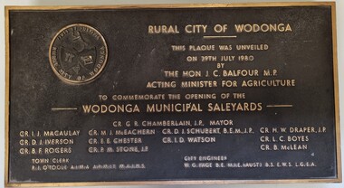
Plaque - Opening of Wodonga Municipal Saleyards 1980
This plaque commemorates the opening of the Wodonga Municipal Saleyards, named the W. G. Page Saleyards, in 1980. The last sales at this facility took place in February 2015 before being replaced by the privately-run Barnawartha North's Northern Victoria Livestock Exchange. William George Page was Shire and City Engineer in Wodonga from 1965 until 1989. When he arrived the Shire of Wodonga had a population of 17,000 people. In 1966 Wodonga was selected as a city for special growth assistance. In 1972 Bill Page presented a new Town Plan to the Wodonga Council. Over the ensuing years he dedicated himself to bring this plan to fruition. He often had to argue and campaign with the Albury-Wodonga Corporation to push for the interests of development in Wodonga. This included winning a planning appeal to allow the saleyards to be relocated to Bandiana on the outskirts of Wodonga. Bill Page retired on health grounds in July 1989. The Council honoured him with a farewell dinner and renamed the saleyards at Bandiana the W.G. Page Saleyards in his honour.The Mayor , Cr Valentina Gillard, said "Every development in Wodonga in the past 24 years has a bit of Bill Page in it". William Page died 3 months later at 58 years old.This plaque commemorates an important centre in the development and support of the livestock industry around Wodonga.A bronze plaque bearing the symbol of the Rural City of Wodonga in the upper left corner and an inscription to commemorate the opening of the Wodonga Municipal Saleyards. It includes a detailed inscription.RURAL CITY OF WODONGA / THIS PLAQUE WAS UNVEILED / ON 29TH JULY 1980 / BY /THE HON. J. C. BALFOUR M.P. / ACTING MINISTER FOR AGRICULTURE /TO COMMEMORATE THE OPENING OF THE / WODONGA MUNICIPAL SALEYARDS CR. G. R. CHAMBERLAIN, J.P. MAYOR CR. I . J. MACAULAY CR. M. J. McEACHERN CR. D. I. SCHUBERT, B'E'N', J.P CR. H. W. DRAPER, J.P. CR. D.J .IVERSON CR. E. E. CHESTER CR I. D. WATSON CR. L. C. BOYES CR. B. F. ROGERS CR. P. M. STONE. J.P CR. B. McLEAN TOWN CLERK R. I. O"TOOLE A.I.M.A., A.R.M.I.T, M.A.I.H.S CITY ENGINEER W. G. PAGE, B.E, M.I.E (AUST) B.S .E.W.S L. G. E. A saleyards wodonga, w. g. page saleyards, livestock sales wodonga -
 City of Kingston
Photograph - Black and white, 1909
In 1880, the Melbourne Benevolent Asylum launched an appeal to raise funds to relocate away from the inner city. The location in North Melbourne was considered a great risk for the residents, particularly the 'old and feeble', in the event of an epidemic. In 1887, the secretary to the Premier of Victoria wrote to the Asylum, suggesting Frankston as a possible alternative to North Melbourne. The Asylum committee considered Frankston to be too far away. The Royal Commission into Charitable Organisations (1890) strongly recommended Cheltenham as the preferred location but the government failed to act on that recommendation. Former Asylum committee member, Mr James Hingston, bequeathed £25,000 to the Asylum on his death in 1902. After many more years of toing and froing, the foundation stone for the new asylum at Cheltenham was laid in 1909. It was almost two years later that the transfer of residents from North Melbourne to Cheltenham began. The move happened in stages over three days, with the first group of residents to move to Cheltenham being 125 women from the invalid wards. The Asylum continued to operate throughout the 20th Century and, in 1970, was renamed the Kingston Centre. The focus of services also changed. This photograph captures the laying of the foundation stone in 1909.Black and white image depicting a large group of citizens gathered to watch the laying of the foundation stone for the Benevolent Asylum in Cheltenham. There is a raised platform with a group of men dressed in suits standing on it. These appear to be the dignitaries for the day. There are flags flying in the background, others standing on poles at the corners of the raised platform. Handwritten in red ink on reverse: 50%cheltenham, charity, north melbourne, welfare -
 Lakes Entrance Historical Society
Photograph - Historic House, 1999
Typical of the flat roofed design of the 1950'sColour photograph of a fibro cement, flat roofed dwelling at 240 Marine Parade. Timber framed corner windows. Front patio tiled with natural stone. Lakes Entrance Victoriahouses, fences, heritage study -
 Surrey Hills Historical Society Collection
Photograph, Holy Trinity Tennis Club, 1941, 1941
Holy Trinity originally held their first organised services during 1885 in the recreation hall in Albany Crescent, Surrey Hills with the Reverend H E Taylor, then Vicar of St Barnabas, Balwyn, conducting the services. Mr E D Dyer donated the land for a church on the corner of Mont Albert Road and St George's Road, Mont Albert with the foundation stone being laid on 17 July 1886. The first church service was held on Sunday, January 30, 1887 with eighty people present. A new site on Union Road, Surrey Hills was acquired (lots 3 & 4) and a wooden church was erected and opened in 1907 on lot 4. It became known as Holy Trinity Surrey Hills. In November 1939 two tennis courts and a pavilion were erected on land acquired by the parish in a lane off Balmoral Crescent. The Holy Trinity Tennis Club had 80 years of distinguished success in match play until it closed in 2014. That land was sold in 2015 and the parish's real estate holdings diversified.Black and white photo of 9 ladies, in tennis dresses and shoes, and 8 men, also in tennis attire. They are posed next to a light coloured building on the right and a paling fence along the back left side. There are 5 men standing at back, 6 ladies and 1 man standing in the next row, 4 ladies sitting in front and 2 men sitting on the ground. Three ladies sitting are holding tennis racquets. There are trees behind the paling fence. Black and white photo mounted on card; photo measures W 11.1 cm x H 6.7 cm.sporting clubs, sports people, tennis, holy trinity anglican church, 1940 - 1949, mrs mary clucas -
 Eltham District Historical Society Inc
Photograph - Digital Photograph, Marguerite Marshall, Jesse Tree playing the Didgeridoo and Swiss Hang Drum at St Andrews Market, 29 March 2008
Published: Nillumbik Now and Then / Marguerite Marshall 2008; photographs Alan King with Marguerite Marshall.; p175 It’s Saturday morning and thousands of people are visiting St Andrews Market at the corner of Heidelberg-Kinglake Road and Proctor Street. It’s hard to find a park. Cars are banked up along the narrow road and crammed in a nearby parking area. Yet, at the market, people look relaxed and happy amongst the yellow box gums on the site where the Wurundjeri people used to gather. Stone artefacts unearthed there by Koorie researcher, Isabel Ellender, indicate the site was once a Wurundjeri meeting place, according to Aboriginal Affairs Victoria. Acoustic sounds mingle with quiet conversations. A guitarist blows a mouth organ while his bare toes tickle chimes. A tiny busker, perhaps five years old, plays a violin while sounds of a harp emerge from the hall. One stallholder, selling delicious-looking pastries, chats to another in Spanish, then to me in broad Australian. ‘I was born in Fitzroy but my mother came from Mexico and my dad from Serbia,’ she smiles. A New Zealander fell in love with Mongolia and now imports their hand-made embroidered clothes and Yurts (tents) and runs adventure tours. A young woman visited Morocco and when friends admired the shoes she bought, she decided to import them and sell them at the market. Oxfam sells Fair Trade toys and clothes and displays a petition to Make Poverty History. Other stalls sell Himalayan salt, jewellery made from seeds from northern Australia, glass paper-weights from China as well as locally grown vegetables, flowers and organic freshly baked bread. A woman sits in a state of bliss under the hands of a masseur. Another offers Reiki or spiritual healing. A juggler tosses devil sticks – ‘not really about the devil,’ he smiles. This skill was practised thousands of years ago in Egypt and South America he says. At the Chai Tent people lounge on cushions in leisurely conversation. The idea for the market was first mooted among friends over a meal at the home of famous jazz and gospel singer Judy Jacques.2 Jacques remembers a discussion with several local artists including Marlene Pugh, Eric Beach, Les Kossatz, Ray Newell and Peter Wallace. ‘We decided we wanted a meeting place, where all the different factions of locals could meet on common ground, sell their goodies and get to know one another,’ Jacques recalls. They chose the site opposite another meeting place, St Andrews Pub. A week later Jacques rode her horse around the district and encouraged her neighbours to come along to the site to buy or sell. On February 23, 1973, about 20 stallholders arrived with tables. They traded ‘second-hand clothes, vegetables, meat, cheese, eggs, chickens, goats, scones, tea, garden pots and peacock feathers’. Now around 2000 people visit each Saturday. People usually linger until dusk. The market – with around 150 stalls of wares from a wide variety of cultures – stands alongside Montsalvat as the most popular tourist attraction in Nillumbik. By the 1990s St Andrews Market was in danger of being loved to death, as the site was becoming seriously degraded. The market was spreading in all directions and the degradation with it. A local council arborist’s report in 1994 noted exposed tree roots from erosion and compaction. The Department of Sustainability and Environment threatened to close the market if the degradation was not rectified. After many months of research, discussions and lobbying by a few residents, the council formed a Committee of Management, with an Advisory Committee, and introduced an Environment Levy. The State Government, the council and the market, funded terracing of the site to stop erosion, and retain moisture and nutrients. Vehicles were excluded from some sensitive areas and other crucial zones reserved for re-vegetation. Volunteers planted more than 3000 locally grown indigenous species. The old Yellow Box trees fully recovered and are expected to give shade for many years to come.This collection of almost 130 photos about places and people within the Shire of Nillumbik, an urban and rural municipality in Melbourne's north, contributes to an understanding of the history of the Shire. Published in 2008 immediately prior to the Black Saturday bushfires of February 7, 2009, it documents sites that were impacted, and in some cases destroyed by the fires. It includes photographs taken especially for the publication, creating a unique time capsule representing the Shire in the early 21st century. It remains the most recent comprehenesive publication devoted to the Shire's history connecting local residents to the past. nillumbik now and then (marshall-king) collection, didgeridoo, jesse tree, st andrews market, swiss hang drum -
 Bacchus Marsh & District Historical Society
Photograph, Old Mechanics Institute Young Street, Bacchus Marsh 1883
A Mechanics Institute in Bacchus Marsh dates from sometime in the 1850s. The foundation stone for this hall dates from 1858. The hall was located on the corner of Young Street and Bennett Street on land donated by James Young. In 1883 a new and larger Mechanics Institute Hall was built in Main Street. The old hall was purchased by Thomas Anderson and for some years was a private residence. It was later bought by the Royal Antediluvian Order of Buffaloes (RAOB) and became a Lodge for that order. In its later years it was known locally as 'The Buff's Hall'. It was eventually demolished in the late 20th century. Built in Young Street on land owned by James Young, a prominent citizen of Bacchus Marsh, this Hall was the venue for the commencement of the political campaign of Alfred Deakin, and later for the campaign of Peter Lalor, a leader of the Eureka Rebellion.Small sepia 'carte de viste' style unframed photograph on card with gold border framing photograph. Housed in the Jeremeas Family Album which contains photographs of Bacchus Marsh and District in 1883 by the photographers Stevenson and McNicoll. The photo is of a single-storey brick building. The front has a gabled entrance with a central doorway and two windows, one on either side of the door. A plaque has been inset in the gable above the door. The hip roof is shingled. Three windows run along the side of the building. A picket fence on very uneven footage runs along the front. The entrance gateway has two steps up to the entry and is decorated with an ornate lantern supported by a slim metal framework. Another lantern is fixed to the left of the front door.Printed On the front: Stevenson & McNicoll. Photo. 108 Elizabeth St. Melbourne. COPIES CAN BE OBTAINED AT ANY TIME. On the back: LIGHT & TRUTH inscribed on a banner surmounted by a representation of the rising sun. Copies of this Portrait can be had at any time by sending the Name and Post Office Money Order or Stamps for the amount of order to STEVENSON & McNICOLL LATE BENSON & STEVENSON, Photographers. 108 Elizabeth Street, MELBOURNE. stevenson and mcnicoll 1883 photographs of bacchus marsh and district, mechanics institutes, halls, bacchus marsh mechanics institute -
St Vincent's Hospital Melbourne Archives
Album - Agnes McLean, photographs at St Vincents Hospital Melbourne, Circa 1926-1928
Photos include nursing colleagues in uniform, in theatre and night duty, social occasions at SVHM. Nurses are in full uniform, cap, starched loose fitting, long sleeved white linen dresses buttoned to drop waist with belt, white stockings and court heeled shoes. Religious Sisters of Charity in black winter habits. Laying of Foundation Stone 1928 celebrations Druids Wing, Brenan Hall.st vincent's hospital melbourne, brenan hall, religious sisters of charity, nurses -
 Port Melbourne Historical & Preservation Society
Photograph - Digital files relating to Thomas Joseph Fitzgerald & family, c.1950
Thomas Fitzgerald was a plumber and gasfitter who lived with his father (same name) at 12 Poolman St Port Melbourne. He married the donor's mother Dorothy Joyce Stone in 1952 (her family lived at 17 Poolman St) and they bought 77 Ross St Port Melbourne (corner Clay and Ross sts) The property was a former Police Station with stables at the rear. Thomas died in March 1967 leaving Dorothy (known as Joyce) with six young children. The family lived there until 1970 when the property was sold and they moved to Glen Waverley. The children all attended Graham St Primary SchoolA number of digital images; career details & copy of Plumber's Certificate.thomas josephs fitzgerald, business and traders - plumbers -
 Eltham District Historical Society Inc
Work on paper - Folio, Register of Significant Trees, Shire of Eltham, c.1993
In 1983, the National Trust advised the Shire of Eltham that it was investigating a number of trees within the shire which had been nominated for recording the Register of Significant Trees of Victoria. The trees involved were described in the Shire of Eltham Historical Society Newsletter No. 29, March 1983 as follows:- 1. Eucalyptus melliadora (Yellow box) . a) An outstanding mature specimen 42 metres high in Laughing Waters Road, Eltham. b) Another mature specimen in Arthurs Creek road, Hurstbridge is reported to be the tree under which the bushranger Robert Bourke was tied after he shot and killed Henry Hurst in 1866 . 2. Quercus robur (English Oak). a) "Donaldson's Oak", Donaldsons Road, Kangaroo Ground was planted by John Donaldson from seed collected from Windsor Great Park in 1878. b) "Wippells Oak". This now misshapen tree is located on the St. Andrews Road near the Kangaroo Ground Fire Station. Its origins may have been similar to Donaldson's Oak, and as a young tree it apparently slipped from higher up the hill during wet weather. Both oaks are of local historical importance. 3. Eucalyptus globulus (Blue Gum). A large mature specimen at the corner of the Kangaroo Ground-St. Andrews Road and Bakehouse Road, Panton Hill. 4. Plantanas acerifolia (Plane tree) A number of trees forming the Avenue of Honour to Eltham's First World War soldiers along Main Road between Dalton and Pitt Streets, Eltham. 5. Pinus canariensis (Canary Island Pine), Pinus pinea, (Stone pine) and Cedras altlantica, (Cedar) These trees are located at the Hurst family graves in the grounds of the Hurstbridge Pre-school Centre. In 1991 the Shire of Eltham introduced controls into its planning scheme to protect sites of architectural, historic or conservation interest and significant trees. The controls were approved by the Minister for Planning and Housing. As advised in the Shire of Eltham Historical Society Newsletter No. 78, May 1991, a planning permit is required to demolish or alter any listed building or to destroy, lop or remove any listed tree. Provision is made for comments to be obtained from the National Trust or Historic Buildings Council in considering any applications. The buildings and trees listed were: Buildings: 250 Bolton Street Eltham (former Walter Withers home) "Rosehill" - Bonds Road Lower Plenty St Andrews Church of England - St Andrews "Montsalvat" - Hillcrest Avenue Eltham St Margarets Church and former vicarage - Pitt Street Eltham Presbyterian Church - Kangaroo Ground Parks and Environment Office (former police quarters) Main Road Eltham Former Court House - Main Road Eltham "Shillinglaw Cottage" - Main Road Eltham "The Robins" - Kangaroo Ground Road Warrandyte Trees: "Donaldsons Oak" - Donaldsons Road Kangaroo Ground Yellow Box - Laughing Waters Road Eltham Yellow Box - Arthurs Creek Road Hurstbridge Wippells Oak - St Andrews Road Kanqaroo Road Pines and Cedar - Hurst family cemetery Greysharps Road Hurstbridge Yellow Box - Parsons Road Eltham A large Blue Gum at Panton Hill has been listed but has recently died (1991). In 1993 work by Council Parks and Environment staff and volunteers resulted in the preparation of a Significant Tree Register listing forty-one trees or groups of trees. According to Shire of Eltham Historical Society Newsletter No. 91, March 1993, a similar number remained to be assessed for inclusion in the register. There is a wide range of indigenous and planted trees on private and public land and extending through the Shire of Eltham from Lower Plenty to Kinglake. Most can be viewed from publicly accessible locations. The Significant Tree Register lists 41 trees or groups of trees throughout the Shire. It contains a wide range of naturally occurring and planted trees. They have been assessed according to eleven criteria including size, age, rarity, historical value and the like. The list includes large old Red Gums at Lower Plenty, historic Oaks at Kangaroo Ground and Mountain Ash at Kinglake. The register includes a set of slides showing each tree. Garry Bartlett of the Council's Parks and Environment Section and Faye Shepherd were extensively involved in establishment of the register (Newsletter No. 93, November 1993). In 1999 Niliumbik planners prepared an amendment to the Planning Scheme to provide protection for approximately 200 of the places listed in the heritage studies and also in the Significant Tree Register commenced by the Eltham Council (Eltham District Historical Society Newsletter No. 127, July 1999. In 2004, The Register of Significant Trees was presented to the Eltham District Historical Society by Nillumbik Shire Council as part of a wider collection of of its memorabilia of the former Eltham Shire Council (EDHS Newsletter No. 159, July 2004. Album of loose handmade paper sheets contained within a handmade slip cover constructed of handcrafted card with encapsulated flora material (flowers, vines, ferns) and tinted. Each page also contains an embedded/adhered fern leaf also tinted with lacqueur or similar, text as appropriate in ink by hand calligraphy. Each page also has a white protective sheet cut to size and adhered to back surface with sticky tape and folded over face of page. Pages variously have photographs and coloured masks adhered with a gum resin. Over time much of this resin has let go and photos/masks have been reattached using acid free archival safe adhesive. 15 pages 41 x 29 cm inclusive of 3 blank pages. Slip case 42 x 30 x 1 cm; face cover of slip case has broken off at left hand margin as insufficient depth/flexibility for contents.arthurs creek road, blue gum (eucalyptus globulus), canary island pine (pinus canariensis), couties road, donaldsons oak, donaldsons road, eltham, english oak (quercus robur), eucalyptus melliodora, graysharps road, hurst tree, hurstbridge, ironbark (eucalyptus tricarpa), ironbark hill, kangaroo ground, kangaroo ground-kinglake road, laughing waters road, panton hill hotel, panton hill, parsons road, significant trees register, sonia van bodegraven, sonjart, stone pine (pinus pinea). atlantic cedar (cedrus atlantica), wippells oak, yellow box gum (eucalyptus melliodora), yellow box gum -
St Vincent's Hospital Melbourne Archives
Album - Agnes McLean photograph album, Souvenir St Vincent's Melbourne, the foundation stone new wing 1928
Images in the album are related to the laying of the foundation stone of St Vincent's new wing in 1928 as well as the royal visit of the Duke and Duchess of York in 1927. A loose newspaper clipping contained in the album titled "Fitzroy's Welcome" provides information on the royal visit which extended into Fitzroy, Collingwood and Richmond. A minute photo on page 18 of the album shows an image of the royal yacht. Album contents and descriptions written: Page 1, Mother Mary Aikenhead foundress of the Sisters of Charity. Page 2, Mother Mary Berchmans foundress of St Vincent's. Page 3, The Papal Legate Cardinal Cerretti XX1X eucharistic congress laying of the foundation stone SVHM1928. Page 4, His Grace the Archbishop of Melbourne the most Rev Daniel Mannix 1928. Page 5, The stand from which the cardinal addressed the meeting. Page 6, En route to "Stand" SVH. Page 7, The stone ready to be blessed. Page 8, The Cardinal going to bless the stone. Page 9, The blessing of the stone. Page 10, Listening to the Cardinal. Page 11, The mallet and the trowel used. Page 12, The stone is well and truly laid, Page 13, Via the enclosure. Page 14, St V's nurses. Page 15, The Subway. Page 16, En route to Reception Hall. Page 17, The Reception Hall. Page 18, The Stage Garlands, CLC students entertained. Page 19, Royal visit His RH the Duke of York. Page 20, The Duchess of York. Page 21, The living check. Page 22, The guard of honour SVH nurses. Page 23, Fire station en fete opposite SVH. Page 24, Victoria Parade for a Royal Visit.Each page has script style black ink descriptions of the photograph.archbishop daniel mannix, mother mary berchmans daly, cardinal bonaventura cerretti, duke of york, duchess of york, mother mary aikenhead, st vincent's hospital melbourne, nurses, victoria parade, eastern hill fire station., tunnels, brenan hall -
Canterbury History Group
Photograph - Foundation Stone of the Uniting Church on the corner of Canterbury Road and Hopetoun Ave., Canterbury, Jan Pigot, 1994
Coloured photograph of Foundation Stone of the Uniting Church on the corner of Canterbury Road and Hopetoun Ave., Canterburycanterbury, canterbury road, churches, signs -
 Whitehorse Historical Society Inc.
Pamphlet, Yarran Dheran, 26/02/2025
4 pamphlets 1. Welcome to Yarran Dheran Nature Reserve 2. Stepping Stones for Wildlife 3. Birds of Yarran Dheran 4. Butterflies4 pamphletsnon-fiction4 pamphlets 1. Welcome to Yarran Dheran Nature Reserve 2. Stepping Stones for Wildlife 3. Birds of Yarran Dheran 4. Butterfliesyarran dheran, city of whitehouse -
 Ringwood and District Historical Society
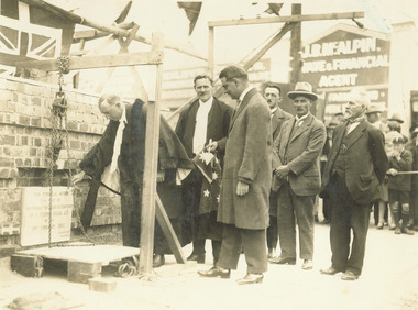
Photograph, Mayor A.T. Miles laying foundation stone of the Ringwood town hall, 1927
Black and white photograph (2 copies, 1 mounted on cardboard backing).Typed below photograph: "Mayor A.T. Miles laying foundation stone of the town hall - Corner of Main Street and Melbourne Street 19.2.1927." Written on rear of cardboard backing: "Mayor A.T. Miles laying stone of town hall, C/r Main St. & Melbourne St. Sept 1927. Town Clerk A.F.B. Long, Architect A.C. Leith, Builder J. Roberts, Brick contractor J. Hayden from Lilydale."