Showing 1815 items
matching a view street viewing
-
 St Kilda Historical Society
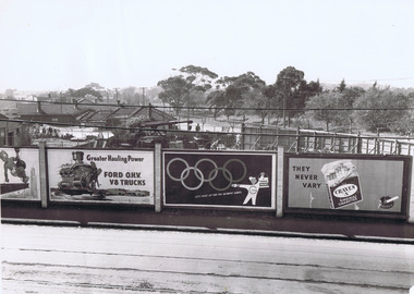
Photograph, View across Ormond Rd to St Kilda St and the Golf Links
... Carlisle Street St Kilda melbourne Photograph View across Ormond Rd ...Shows advertising hoardings showing ads for Greater Hauling Power Ford OHV V8 Trucks, Tanox Paints, "let's paint for the Olympic Games", Craven A Virginia Cigarettes "They Never Vary"black and white photograph, unmounted, original, fair condition (small rip in corner)On back: View across Ormond Rd to St Kilda St & golf links -
 Robin Boyd Foundation
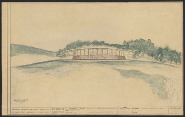
Drawing - External perspective, Tower Hill Lake Reserve Museum, Jun-61
In 1961 Robin Boyd designed the Tower Hill Reserve Visitors Centre to fit naturally within the surrounding terrain. The building’s shape reflects a volcanic cone. The windows allow a 360-degree view of the park. The Centre opened just after Robin Boyd’s death in October 1971. Project: Tower Hill Lake Reserve Museum drawn by Robin Boyd of Grounds, Romberg & Boyd. Drawing no 2. General view and external perspective. Watercolour on dyeline. tower hill, robin boyd, ohm2022, ohm2022_15 -
 Robin Boyd Foundation
Slide, Robin Boyd, 1950
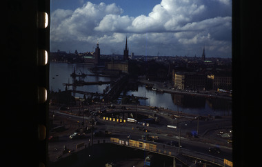
Penleigh Boyd, Robin and Patricia Boyd's son, writes “Prior to 1950 Robin, like most other amateur or hobby photographers, took black and white printed photographs. The oldest slides date from 1950 when Robin and Patricia travelled to Europe on Robin’s Robert Haddon Travelling Scholarship.” In 1948 Robin Boyd was awarded ‘joint first place’ in the Robert Haddon competition for his design of Mildura art gallery. The scholarship helped fund their first overseas trip. Robin and Patricia were passengers on the Greek ship “Cyrenia” departing in May 1950, passing through the Suez Canal and landing in Genoa five weeks later. For six months, they travelled extensively throughout Europe (predominantly driving themselves) - France, Italy, United Kingdom, Sweden, Denmark, Germany, Austria, Switzerland and Spain.Colour slide in a mount. View from Gondolen restaurant (above Katarina Elevator), with view of Stockholm City Hall (golden top of tower, to the left), Stockholm, Sweden (see also item S0365)Stockholm / Gondola / From The Gondola Clover Leaf, To Town Hallhaddon travelling scholarship, haddon, robin boyd, slide -
 Robin Boyd Foundation
Slide, Robin Boyd, 1950
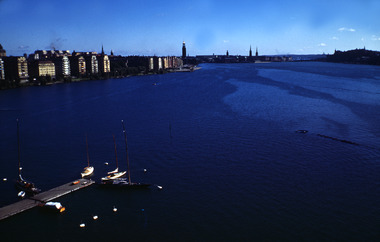
Penleigh Boyd, Robin and Patricia Boyd's son, writes “Prior to 1950 Robin, like most other amateur or hobby photographers, took black and white printed photographs. The oldest slides date from 1950 when Robin and Patricia travelled to Europe on Robin’s Robert Haddon Travelling Scholarship.” In 1948 Robin Boyd was awarded ‘joint first place’ in the Robert Haddon competition for his design of Mildura art gallery. The scholarship helped fund their first overseas trip. Robin and Patricia were passengers on the Greek ship “Cyrenia” departing in May 1950, passing through the Suez Canal and landing in Genoa five weeks later. For six months, they travelled extensively throughout Europe (predominantly driving themselves) - France, Italy, United Kingdom, Sweden, Denmark, Germany, Austria, Switzerland and Spain.Colour slide in a mount. View for bridge, Stockholm, SwedenStockholm / View / From Bridge (All Handwritten)haddon travelling scholarship, haddon, robin boyd, slide -
 Hume City Civic Collection
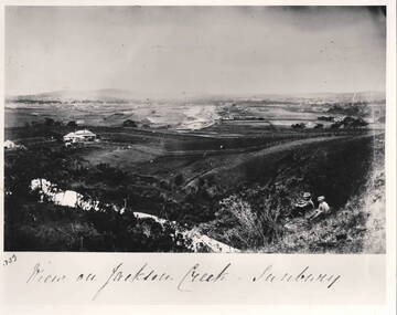
Photograph - View of Jackson Creek Sunbury, c1870
... Hume City Civic Collection 40 Macedon Street Sunbury ...The photograph was taken on a rise overlooking the early settlement of Sunbury with Mount Holden and other hills across the skyline. The five arch railway bridge is visible in the distance on the RHS of the image. Two of Sunbury's early hotels, the John Franklin and the Ball Court are across the middle distance. Craiglee Vineyard with the vines growing is in the foreground. A black and white photograph with a white border.Written across the bottom: VIEW OF JACKSON CREEK SUNBURYsunbury, vineyards, jackson creek, craiglee vineyard -
 Hume City Civic Collection
Photograph, pre 1970
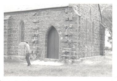
The photograph of St Mary's Anglican Church at Bulla was taken before the completion of the airport at Tullamarine. Originally the church occupied a site on Oaklands Road near the Old Bulla Road. It was shifted to its present site in Bulla next to the old council chambers when the airport was built because the old site was near an important runway.A black and white photograph of a partial view of a bluestone church showing a rear and side view. There are three simple pointed arch windows across the restry and one on the side wall and a wooden door leading into the vestry.st mary's anglican church, bluestone buildings, george evans collection -
 Hume City Civic Collection
Photograph
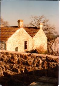
This is a photograph of one of the many stone ruins of buildings which can be seen in the Sunbury district and surrounding areas. This series of 13 photographs show various views of one of the remaining uninhabited stone cottages which were built in the early days of the district's settlement.A coloured photograph of a stone cottage with a wooden shingle roof and the remains of the outbuilding. There is a stone wall across the front of the building. The side view of the building is prominent and there is one 12 paned sash window in the wall and two chimneys either side of the roof valley. A bare deciduous tree is behind the building.stone structures, shingle roofs, george evans collection -
 Hume City Civic Collection
Photograph, c late 1980s
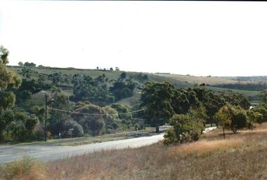
The photograph shows a section of the original settlement of the Bulla township. The cutting on the hillside is significant as it is the remains of one of the original stream crossings in Victoria.A coloured photograph of the Bulla Hill along Sunbury Road with a view of the cutting on the distant hillside. The photograph is a view of the old Bulla township looking to the NW. There is a wide grassy verge in the foreground.bulla township, deep creek, wright, william 'tulip', sunbury road, george evans collection -
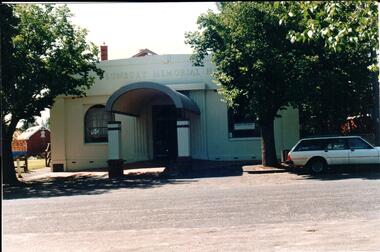 Hume City Civic Collection
Photograph, early 1990s
The Sunbury Memorial Hall was originally the Mechanic's Institute which was built on the present site in 1885. The hall was remodelled in 1922 and renamed the Sunbury Memorial Hall. The building was used until the 1960s as the meeting place by the Shire of Bulla Council. Over the years it has continued to be used for community activities.A coloured photograph of the front view of the Sunbury Memorial Hall with a view of the portico with a front window on either side. The portico has a rounded iron roof and the two front windows are arched. The rendered front of the hall has been painted cream with grey and maroon trim. There are trees growing on either side of the hall and a car is parked on the RHS of the photograph. Part of the village green is visible on the LHS of the photograph.sunbury memorial hall, returned serviceman's league, mechanics institute, shire of bulla council, george evans collection -
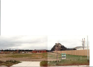 Hume City Civic Collection
Photograph, early 1990s
... Hume City Civic Collection 40 Macedon Street Sunbury ...The series of 5 photographs feature different views of the Woodlands housing development which opened up land bounded by Gap and Anderson Roads, Cornish Street and Elizabeth Drive in the early 1990s. It was a large housing development built close to Sunbury township.A view of the northern boundary of the Woodlands housing development in Anderson Road. A paling fence divides the estate from the 'Malley' factory, now 'Storage King' which is on the corner of Cornish Street and Anderson Road. A 'For Sale' sign is in the foreground and a partly built house is in the middle distance.housing developments, anderson road, george evans collection -
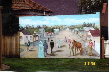 Hume City Civic Collection
Photograph, Sunbury Mural, 3rd July 2001
... and Jackson Street. The view in the mural is looking east towards... between Jacksons Creek and Jackson Street. The view in the mural ...The mural of the artist's image of early Sunbury was painted on the garage wall of the Sunbury Presbytery. It could be viewed from the former court house garden. The first businesses opened in Sunbury in Macedon Street between Jacksons Creek and Jackson Street. The view in the mural is looking east towards Jacksons Creek.When the railway service reached Sunbury in 1859, the business area then relocated from Macedon Street to the Evans and O'Shanassy Streets precinct. Some businesses still exist at the original Macedon Street site.A coloured scanned photograph of a mural which was painted on a brick wall.murals, early sunbury, macedon street -
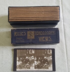 Numurkah & District Historical Society
Slides / Photos / Brush/comb sets / Telescopic view photo set / Tie pin
All of these items were donated by Jock Adams (He was on the Ulupna Island Committee and hence some of the donated photosPhotos - Morgan's Beach, Coonanga Homestead, Barmah Hotel, Ulupna Island Slides - Moira Forest shrubs etc 2 x Brush comb sets Sword/Dagger Tie Pin King George V Coronation Stereo Telescopic View photo set (1911)jock adams, tie-pin, photos, brush-comb set, telescopic view photos, slides -
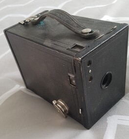 Numurkah & District Historical Society
Box Camera, Eastman Kodak Co
Black leather-leather look (Vinyl) rectangular box. Main lens and 2 viewfinder lenses on the front. Black leather handle, one view finder and metal opening latch on the top. One view finder and a winder key on the right hand side. Red film counter viewing window on the back, with markings (see below)No.2 Brownie / Use film No. 120 / Made in US by Eastman Kodak Co. Rochester NY -
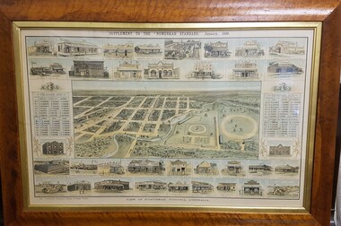 Numurkah & District Historical Society
Map - Print in frame - Numurkah Township 1888, Supplement to the "Numurkah Standard" January 1888 View of Numurkah Victoria Australia
... 1888. Artist's view/impression of Numurkah streets (map... Standard 1888. Artist's view/impression of Numurkah streets (map ...The late Hilda Morieson (very active in early Historical Society) owned the print. It was then passed on to Mary Morieson, then to Rosemary Kennet. It has been passed onto the Historical Society with permission from Ben Morieson, Hilda's grandsonLarge coloured print of supplement to Numurkah Standard 1888. Artist's view/impression of Numurkah streets (map) surrounded by artwork of a number of Numurkah businesses in the town and local district. The print is under glass in a faux-wood-grained framesee photo abovenumurkah standard, numurkah township map, numurkah businesses, 1888, print -
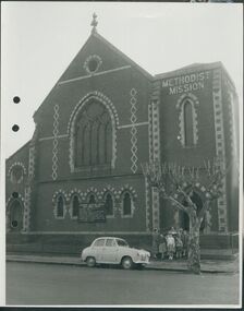 Uniting Church Archives - Synod of Victoria
Photograph, undated
... Church. The image is a street view of a group of children.... The image is a street view of a group of children and an adult ...The Gipps Street Wesleyan Methodist Church of 1874 and the adjoining school hall, were built in the Collingwood Flat area - one of the municipality's poorest areas. In 1903, the Collingwood Methodist Mission was established with its headquarters in the Gipps Street Church. Six Methodist Missions were created in inner Melbourne. Three churches were operated by the Collingwood Mission. They were: Sackville Street Collingwood, Elizabeth Street, North Richmond (demolished), and Gipps Street Collingwood (demolished). The Mission operated until approximately 1930.B & W exterior view of the Gipps St. Collingwood Methodist Church. The image is a street view of a group of children and an adult standing in front of the brick church.gipps st. methodist church, les gorrie, collingwood mission -
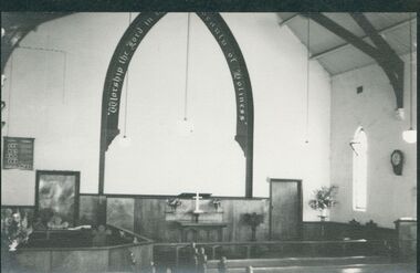
 Uniting Church Archives - Synod of Victoria
Photograph, Sale Methodist Church, c.1960
The Sale Methodist Church was opened in 1865. It was replaced with a new church in 1965.B & W interior view of the Sale Methodist Church. View of the apse with font, communion table and wall painted arch "Worship the Lord in the beauty of Holiness".sale, methodist church, apse, painted arch -
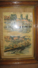 City of Warrnambool Rowing Club
Picture (copy), "Points of View"
Half page illustration from Punch p. 37. Two panel illustration by G.D. Armour titled 'Points of View' and subtitled 'The River as it Appears to the Winners of an Easy Race' showing starboard view of a straight four rowing erect and without obvious distress. Below 'As it Appears to the Losers of a Hard Race' showing closeup starboard stern quarter view of a straight four collapsed over their oars, with the surrounding scenery drawn in a wavy haze. Part of the Tom Weil Collection. Thomas E Weil is a very knowledgeable and respected collector of rowing memorabilia from all over the world. His extensive collection includes material from many years of the Oxford and Cambridge University Boat Race, and Henley Royal Regatta. He also lectures and writes on rowing history and is a Trustee of the River and Rowing Museum. River & Rowing Museum, Mill Meadows, Henley on Thames, Oxfordshire, RG9 1BF Telephone: 01491 415600 General enquiries: [email protected] of an Ink and watercolor painting of two rowing crews. Two panel copy of an illustration by G.D. Armour titled 'Points of View' and subtitled 'The River as it Appears to the Winners of an Easy Race' showing starboard view of a straight four rowing erect and without obvious distress. Below 'As it Appears to the Losers of a Hard Race' showing closeup starboard stern quarter view of a straight four collapsed over their oars, with the surrounding scenery drawn in a wavy haze.Points of view G.D. Armourcity of warrnambool rowing club, warrnambool rowing club, hopkins river warrnambool, hopkins river warrnambool, g.d. armou, 'points of view' -
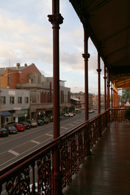 Old Colonists' Association of Ballarat Inc.
Photograph, Clare Gervasoni, View from the Balcony of the Ballarat Old Colonists' Hall, 2017, 23/03/2017
... View down Lydiard Street North from the verandah of the Old... (North) Street Ballarat Central goldfields Photograph View from ...The Old Colonists' Hall opened in 1887.View down Lydiard Street North from the verandah of the Old Colonists' Hall.ballarat old colonists' club, ballarat old colonists' hall, balcony, lydiard street -
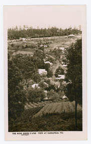 Mt Dandenong & District Historical Society Inc.
Photograph, View at Sassafras, Vic, c1930
... View down the Main Street of Sassafras looking south..." Armadale. Victoria View down the Main Street of Sassafras looking ...View down the Main Street of Sassafras looking south with the Mechanics Institute in the centre of the picture. The raspberry patch in the foreground belonged to Woniger Hansen who built Mountain Rest (Rostrevor). The land was subdivided after his death in 1923. The raspberry patch is in the area of the current Mason Grove.Black and white Rose Series postcard P. 4765 looking south down the Main Street of Sassafras with buildings either side and berry patches in the foreground.On reverse POST CARD. THE "ROSE' SERIES DELUXE. A REAL PHOTOGRAPH PRODUCED IN AUSTRALIA. PUBLISHED BY 'THE ROSE STENOGRAPHS" Armadale. Victoria sassafras, rose series, rostrevor, woniger hansen, hansen, mechanics' institute, raspberry, raspberry crop, mountain rest, mason grove -
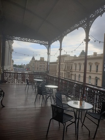 Old Colonists' Association of Ballarat Inc.
Photograph, Clare Gervasoni, View from the Balcony of the Ballarat Old Colonists' Hall Looking South, 2017, 23/03/2017
... View down Lydiard Street North, looing south, from... (North) Street Ballarat Central goldfields Photograph View from ...View down Lydiard Street North, looing south, from the verandah of the Old Colonists' Hall.ballarat old colonists' club, ballarat old colonists' hall, balcony, lydiard street -
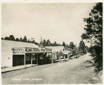 Mt Dandenong & District Historical Society Inc.
Photograph, Street View, Olinda, late 1930s
... Street View, Olinda...Small photograph, number 1 in Olinda series, showing a view...-and-the-dandenong-ranges Photograph Street View, Olinda Small photograph ...Number 1 in commercial series.Small photograph, number 1 in Olinda series, showing a view of the Main Street of Olinda late 1930s. V.J. Boulter's Olinda General Store with butcher and bakery in foreground. Road not yet made.boulter, v.j. boulter, general store, butcher, bakery, olinda -
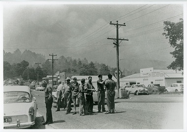 Mt Dandenong & District Historical Society Inc.
Photograph, Street view Mt Dandenong during 1962 bushfires, 1962
... Street view Mt Dandenong during 1962 bushfires...-and-the-dandenong-ranges Photograph Street view Mt Dandenong during 1962 ...Taken during the 1962 bushfires. View of Mount Dandenong shops opposite the Hotel with garage to the right. 8 men in foreground with smoke clearly visible.mount dandenong, mt dandenong road, bushfire -
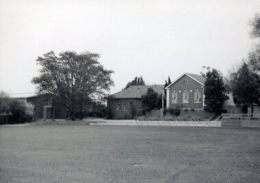 Camberwell Girls Grammar School
Photographs - original, Circa 1965
Collection of 21 black and white and 3 colour photographs taken approximately in 1965 of the School buildings and grounds. Views of the Oval with classrooms and J.G. Robinson Hall located near the well-loved fig tree. View of J.G. Robinson Hall and the P.W. Oval taken from the 1955 second storey addition to the Woodstock building. Exterior and interior views of the Woodstock Building including interior views of the science laboratory opened in 1960. The J.G. Robinson Hall was used for a variety of events including assemblies; gymnasium and performances. -
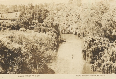 Kew Historical Society Inc
Photograph, River Yarra at Kew, c.1927
... Yarra at Kew. The bird's eye view, presumably taken from... postcard of the River Yarra at Kew. The bird's eye view, presumably ...The River Yarra was a popular subject for photographic postcards. The postcards provide an interesting perspective of plantings on the banks of the Yarra at various periods. Small, sepia coloured real photo postcard of the River Yarra at Kew. The bird's eye view, presumably taken from Victoria Street Bridge shows the banks of the Yarra in the foreground densely planted with weeping willows. There is also canoe in the foreground. The expanse of lawn in the middle ground is that of 'Swinton', the tower of which can faintly be seen at the top centre of the view. "RIVER YARRA AT KEW / REAL PHOTO SERIES M. 2908 "real photo postcards, yarra river -- kew (vic.), postcards -- 1920s -
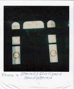 Kew Historical Society Inc
Photograph - 'Otira', 73 Walpole Street, 1978
Sanderson P (1988): '73 Walpole Street (Kew), 'Otira'. Built 1887. Original use - Residence. Architect - Crouch. Henry Berry, a noted philanthropist and salt merchant of Melbourne, was the original owner of this two-storey, boom-period house. Berry occupied the residence until his death in 1923 while in February the following year, the property was auctioned. Subsequently purchased by the Methodist Church for use as a training college for missionaries, a number of additions and alterations were made at that stage including a memorial chapel that was built on the property in 1957.' Otira is now a private residence. Original colour positive photograph (polaroid) of 'Otira', 73 Walpole Street, Kew, taken in 1978 by students in Form 3R at Trinity Grammar School as part of a project. The view is of the painted glass panels surrounding the main door, viewed from the hall."Photo 4 / Stained glass door panels Otira"otira - 73 walpole street, henry berry, historic houses -- kew (vic.), trinity grammar school, melbourne architects -- crouch, interior design -- front doors -- 1880s, interior design -- painted glass -- 1880s -
 Kew Historical Society Inc
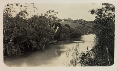
Photograph - Macauley's, Kew, 1924
Henry Beater Christian (1886-1962) , was a descendant of one of the earliest settler families in Kew. Employed at the Kew Asylum as a 'public servant', he was a skilled amateur photographer, photographing numerous scenes in Kew and on his travels around Victoria. The majority of his photographs date from 1916 to 1929. His finest photographs are housed in two photograph albums. A fine, early view of Macauley's boat sheds on the Yarra River at Kew. It is also one of the earliest views of Carnsworth, a notable mansion in Studley Park. Digital copy of a photograph from page 2 of the 47-page photograph album containing 261 gelatinous silver images, loaned by Diane Washfold with permission given to digitise and hold a copy in our collection. The photograph is of a stretch of the Yarra River at Kew. In the foreground are the boats of Macauley's Boat Sheds. On the horizon is the red brick tower of J Lewis Carnegie's house 'Carnsworth' in Stawell Street. "Macauley’s Kew"henry beater christian (1886-1962), landscape photography, kew (vic.) — yarra river, christian-washfold collection, photograph albums, macauley's boat sheds, carnsworth -- stawell street -- kew (vic.) -
 Kew Historical Society Inc
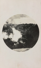
Photograph - Yarra River, Studley Park, 1924
Henry Beater Christian (1886-1962) , was a descendant of one of the earliest settler families in Kew. Employed at the Kew Asylum as a 'public servant', he was a skilled amateur photographer, photographing numerous scenes in Kew and on his travels around Victoria. The majority of his photographs date from 1916 to 1929. His finest photographs are housed in two photograph albums. Digital copy of a photograph from page 7 of the 47-page photograph album containing 261 gelatinous silver images, loaned by Diane Washfold with permission given to digitise and hold a copy in our collection. This photograph was taken during a flood year, perhaps 1923, when the Yarra encroached on the grounds of the Abbotsford Convent. In the distance, the Johnston Street Bridge separates the viewer from the industrialised landscape of Fairfield. In developing the photo, Henry Christian employed a circular frame to artistically focus the view. He empkloyed this technique for what he may have viewed as his best photographs. "Studley Park / Kew"henry beater christian (1886-1962), landscape photography, kew (vic.) — yarra river, christian-washfold collection, photograph albums, fairfield, kew, johnston street bridge, studley park -
 Kew Historical Society Inc
Card - View of Melbourne, 1950s
... Street, Kew, with two photographic views of Melbourne on cover... Fellows Street, Kew, with two photographic views of Melbourne ...An item from an outstanding and diverse photographic collection, assembled by members of the Christian and Washfold families of Kew.Black and white photogravure reproduction. Large greeting card sent by Cr and Mrs Comeadow, of ‘Sunny South’, 32 Fellows Street, Kew, with two photographic views of Melbourne on cover and inside.washfold family, w a comeadow, christian-washfold collection -
 Kew Historical Society Inc
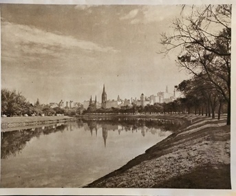
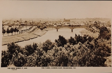
Postcard, Rose Stereograph Company, The Yarra Looking East, Melbourne, Vic
One of a number of 'real photo' and commercial postcards created by or owned by members of the Christian and Washfold families of Kew. The postcards are part of a larger collection of photographs, postcards and publications donated to the collection in May 2021.View of Melbourne on the horizon, looking in an easterly direction along the River Yarra. A State Library of Victoria catalogue record says ‘Elevated view along Yarra River, trees in foreground, line of saplings along both banks of the river, bridge in background (possibly Johnson Street Bridge)’. This may be incorrect.The Rose Series P. 3480yarra river -- melbourne, postcards -- yarra river, the rose series postcards, christian-washfold collection