Showing 13915 items
matching bridge-dalgety-snowy-river
-
 Eltham District Historical Society Inc
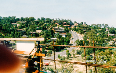
Photograph, Southeast view from new bridge over Plenty River looking along Plenty River Drive, Greensborough Bypass construction, c.1986, 1986c
Mura Close and Tangari Court visible on left, Warriparri Crescent on right of Plenty River Drive.Colour photograph originally located in a magnetic style album titled 'Greensborough Bypass 1990s 5' suffering significant degradation. No information contained in album or on reverse of photos except where noted. Relocated to archival photosafe storage.greensborough bypass, road construction, greensborough, mura close, tangari crescent, plenty river drive, warriparri crescent -
 Melton City Libraries
Photograph, Melton Railway Bridge, c.1884
"The Melton Viaduct, opened in 1886, is of State heritage significance as a very large and visually distinctive wrought iron, lattice girder trestle bridge over the Werribee River (now Melton Reservoir). It comprises 18.3 and 9.1 metre spans, in a generally alternate arrangement, of total length 375 metres, and standing 38 metres over the Werribee River. Wrought iron small section iron was used to build tension trussed trestle legs, which supported four lines of rivetted wrought-iron deck-type double lattice trusses. It has bluestone abutments and pier bases of coursed rock-faced bluestone with drafted margins. The larger half-piers, now usually submerged in the Melton Reservoir have sharp tapered cutwaters and curved coping at the tops. While designed to carry two rail tracks it has only ever been used as a single track line. Despite several alterations to its deck structure, it remains an outstanding example of a lighter structural design employing open metal trestle supports and metal truss girders. The direct Melbourne to Ballarat railway link of which the Melton viaduct was the major engineering work contributed significantly to the history and development of Victoria. This new link reflected Ballarat’s diversifying economy as well as the commercial and political influence of the metropolis. Construction of the bridge, and the associated large workers camp, were extensively photographed, documenting an important episode in local history. The railway enabled the development of new industries in the Melton area, notably the timber industry and a chaff industry of national importance, greatly facilitated the later transition of the Shire from a pastoral to a farming economy, and struck a major blow to Melton township’s era as a wayside town servicing Ballarat road (especially coach) traffic". Melton Railway Bridge being built across the Werribee Rivertransport -
 Phillip Island and District Historical Society Inc.
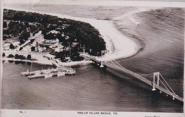
Photograph, Phillip Island Bridge, 1940
The bridge built around 1939. Fishing fleet. Twin jetties to left of bridge, township, bush and wide sand strip of surf beach.Bridge between Phillip Island and San Remo. Photograph depicting San Remo onlyNo. 1. Phillip Island Bridge, Vic. Airspy Photolocal history, photographs, bridges, san remo, coastline, bridge, fishing fleet, jetties, bruce bennett -
 Ringwood and District Historical Society
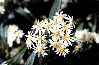
Photograph, Olearia lirata (Snowy Daisy Bush), c. 2000
Common native plant in the Ringwood area.Photograph of Olearia lirata (Snowy Daisy Bush) indigenous to the Ringwood area, Victoria, Australia -
 Eltham District Historical Society Inc
Photograph, Fay Bridge, Ancient Eel trap on the Yarra River at Laughing Waters, Eltham - pre-dating European settlement, 6 September 2023
Laughing Waters is the name for a stretch of the Yarra Valley Parklands consisting of river flats and hilly riparian bushland. With Birrarung (Yarra River) flowing through, Laughing Waters has been an important gathering place for thousands of years. For the Wurundjeri, ‘Garambi Baan’ (the name for Laughing Waters in Woi wurrung) is an important site for growing and harvesting food. Significantly, Wurundjeri iuk (eel) traps remain at Garambi Baan to this day. The Wurundjeri Woi Wurrung People take their name from the Woi wurrung language word ‘wurun’ meaning the Manna Gum (Eucalyptus viminalis) which is common along ‘Birrarung’ (Yarra River), and ‘djeri’, the grub which is found in or near the tree. Wurundjeri are the ‘Manna Gum People’ and their Ancestors have lived on this land for millennia. The site on the Yarra River near the former Morrison property Killeavey was given a language name in 2015 at the instigation of Wurundjeri Elder, Dave Wandin. Garambi Baan means “laughing waters” in the traditional language, Woi wurrung. The site at Warrandyte was rediscovered by Campbell Beardsell OAM in 2007 and is one of only a few known remaining iuk (eel) traps on Country once found the length of the Birrarung (Yarra) and the Maribyrnong. Original Indigenous aquacultural infrastructure was dismantled, taken away from sites and used to build houses, fords and roads by Europeans. The difficult and restricted access to this site is thought to be one of the reasons for its survival. The iuk trap is located within lands managed by Parks Victoria. The Narrap team in partnership with Parks Victoria and Acacia Land Management have been improving the native vegetation with a program of woody weed removal, exclusion fencing and revegetation. Importantly, the team have restored the trap’s infrastructure and have demonstrated its effectiveness.” References: Wurundjeri Woi Wurrung Cultural Heritage Aboriginal Corporation - Laughing Waters. (2023, September 3). Retrieved from https://inplace.org.au/laughing-waters/ GARAMBI BAAN LAUGHING WATERS RESIDENCY CENTRE 2020 2024 Strategic Plan, Nillumbik Shire Council (2023, September 3). Retrieved from https://www.nillumbik.vic.gov.au/files/assets/public/minutes-and-agendas/2020/09-sep/15-sep-cm/ocm.177-20-attachment-1-laughing-waters-arts-program_1.pdffay bridge collection, eel trap, laughing waters, yarra river, wurundjeri woi wurrung, garambi baan, 2023-09-06 -
 Eltham District Historical Society Inc
Photograph, Fay Bridge, Ancient Eel trap on the Yarra River at Laughing Waters, Eltham - pre-dating European settlement, 16 May 2015
Laughing Waters is the name for a stretch of the Yarra Valley Parklands consisting of river flats and hilly riparian bushland. With Birrarung (Yarra River) flowing through, Laughing Waters has been an important gathering place for thousands of years. For the Wurundjeri, ‘Garambi Baan’ (the name for Laughing Waters in Woi wurrung) is an important site for growing and harvesting food. Significantly, Wurundjeri iuk (eel) traps remain at Garambi Baan to this day. The Wurundjeri Woi Wurrung People take their name from the Woi wurrung language word ‘wurun’ meaning the Manna Gum (Eucalyptus viminalis) which is common along ‘Birrarung’ (Yarra River), and ‘djeri’, the grub which is found in or near the tree. Wurundjeri are the ‘Manna Gum People’ and their Ancestors have lived on this land for millennia. The site on the Yarra River near the former Morrison property Killeavey was given a language name in 2015 at the instigation of Wurundjeri Elder, Dave Wandin. Garambi Baan means “laughing waters” in the traditional language, Woi wurrung. The site at Warrandyte was rediscovered by Campbell Beardsell OAM in 2007 and is one of only a few known remaining iuk (eel) traps on Country once found the length of the Birrarung (Yarra) and the Maribyrnong. Original Indigenous aquacultural infrastructure was dismantled, taken away from sites and used to build houses, fords and roads by Europeans. The difficult and restricted access to this site is thought to be one of the reasons for its survival. The iuk trap is located within lands managed by Parks Victoria. The Narrap team in partnership with Parks Victoria and Acacia Land Management have been improving the native vegetation with a program of woody weed removal, exclusion fencing and revegetation. Importantly, the team have restored the trap’s infrastructure and have demonstrated its effectiveness.” References: Wurundjeri Woi Wurrung Cultural Heritage Aboriginal Corporation - Laughing Waters. (2023, September 3). Retrieved from https://inplace.org.au/laughing-waters/ GARAMBI BAAN LAUGHING WATERS RESIDENCY CENTRE 2020 2024 Strategic Plan, Nillumbik Shire Council (2023, September 3). Retrieved from https://www.nillumbik.vic.gov.au/files/assets/public/minutes-and-agendas/2020/09-sep/15-sep-cm/ocm.177-20-attachment-1-laughing-waters-arts-program_1.pdffay bridge collection, 2015-05-16, eel trap, laughing waters, yarra river, wurundjeri woi wurrung, garambi baan -
 Kew Historical Society Inc
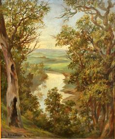
Painting, Herbert J Woodhouse, River Yarra Near Dights Falls, c.1892
Herbert James Woodhouse (1854-1937) was born in Essex and arrived in Australia with his family in 1857. A painter-lithographer like his father and three of his brothers, he was a prizewinner in the South Australian Society of Arts exhibition of 1885. He also received commendations in exhibitions at the Victorian Academy of Arts and the New South Wales Arts Society. At an exhibition of his paintings at Scott’s Hotel in Collins Street in 1892, the reviewer for Table Talk noted that the ‘artist paints almost solely in the open air, and his studies are generally carried out during the trips of the Victorian Sketching Club’. One of the paintings singled out for praise was: ‘A very effective river scene at Willsmere, aptly named A Midstream Mirror, ... a picture powerful in its effective reflection of sunlight in the river.’ Herbert Woodhouse died in Geelong in June 1937, aged 82, and was buried in the Eastern Cemetery. A number of his sketchbooks are held in the collection of the State Library of Victoria.Framed oil painting on board of the River Yarra at Studley Park, Kew, by Herbert James Woodhouse (1858-1937). The artist has framed the narrow painting with trees in the foreground and a view of the Yarra River and rolling hills in the background. Verso, written by artist: "River Yarra Near Dights Falls"australian art - 19th century, herbert james woodhouse (1854-1937), yarra river - studley park -
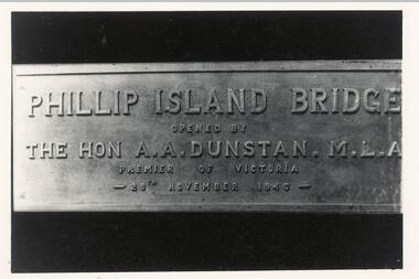 Phillip Island and District Historical Society Inc.
Photograph, Opening of 1st Bridge 1940, 29/11/1940
Donated by Jack Jenner. Commemoration Plaque showing details of first Bridge opening 29/11/1940Photo of Plaque for opening of Phillip Island Bridge - 1st bridge built in 1940. Phillip Island Bridge opened by The Hon. A. A. Dunstan MLA, Premier of Victoria 29th November 1940local history, photography, bridges, phillip island bridge inscription, black & white photograph, jack jenner, phillip island suspension bridge -
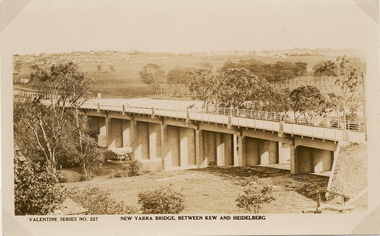 Kew Historical Society Inc
Postcard, Valentine Publishing Co Pty Ltd, New Yarra Bridge, Between Kew and Heidelberg, 1926-1930
Without bridges, Kew remained cut off from the City of Melbourne, only being accessible by Punt. Private and public bridges were constructed from the 1850s, beginning with the Hawthorn Bridge linking Bridge and Burwood Roads. A bridge across the Yarra at Burke Road was created as early as 1873. Since that first wooden bridge, a number of later bridges, typically on concrete pylons have been built, in 1926 and again during the 1970s.Angle view of the new Yarra bridge [ie. The Burke Road bridge] taken from the Kew side, showing the bridge’s structure. Trees line the river’s edge. In the distance can be seen a distant line of houses stretching to the horizon. The river appears to have an S-shaped bend beyond the bridge. The postcard, No. 227, was produced by the Valentine Publishing Co. Pty Ltd., of Queen Street, Melbourne.burke road bridge - kew (vic), bridges - kew (vic) -
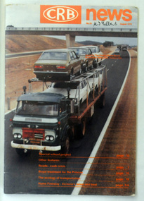 Orbost & District Historical Society
magazine, CRB News, August 1976
By 1910 it had become apparent that there was a need for a central roads authority to take over responsibility from the Board of Lands and Works for the care and management of the main roads of the state of Victoria. Because there was no consistent and systematic policy for road maintenance Victorian roads were in a deplorable condition. At this time the use of the motor car accentuated the demands for better roads. As a result of these needs the Country Roads Act 1912 was proclaimed in 1913 providing for the establishment of the Country Roads Board as a central road authority with responsibility for those roads within the State considered to be main roads. the C.R.B. was responsible for the construction of roads and bridges including the Snowy River road bridges in Orbost. This was a major project involving not only a new bridge over the Snowy River (including Lochiel Lagoon), but other bridges over Ashby’s Gulch and Watt’s Gulch. These new bridges were opened in November 1976 with the unveiling of a plaque on the eastern end of the $2.4M Snowy River Bridge. (ref. May Leatch) This is a useful reference tool on the history of the construction of the Snowy River road bridges.A journal, titled "CRB News" . On the front cover the title is in orange print with No. 33 August 1976 above a coloured photo of a truck carrying two tiers of new vehicles along a main sealed road. It contains information and photos of the construction of the Snowy River road bridges.on front cover - handwritten in black - "M. I. Gilbert"crb-news country-roads-board snowy-river-road-bridges -
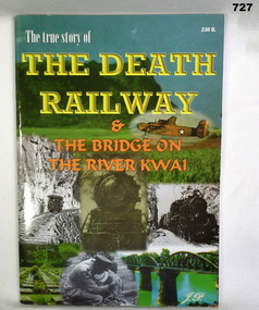 Bendigo Military Museum
Book, The True Story of the Death Railway & the Bridge on the River Kwai
Book is organised by "J.P".Softcover with collage of photos on cover. Photos are of railway locomotives, a bomber, railway bridges and a soldier.Inside front cover "Donated by Trevor Knight"books, military history -
 Warrnambool and District Historical Society Inc.
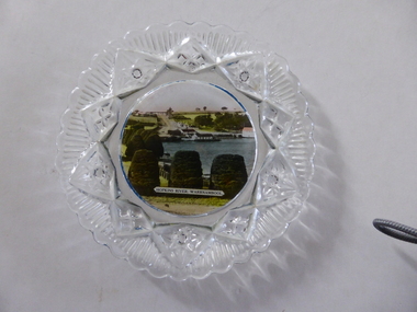
Platter, Transfer Hopkins River
This is a souvenir dish or small plate with an illustration of the Hopkins River in Warrnambool. Included in the illustration are the rowing shed, the boathouses and the lambertiana trees in the property of Lyndoch. The souvenir dish would have been sold to tourists visiting Warrnambool or Warrnambool residents in the 1920s and 30s. This type of souvenir was popular at the time in any tourist town or place in Australia. Tourism has been an important industry in Warrnambool since the late 19th century. This item is of interest as an example of the type of souvenir produced for tourists in the 1920s and 30s. It was both a useful and decorative item. It will be useful for display. This is a small glass souvenir dish. The centre of the dish features a colour illustration of the Hopkins River, Warrnambool (near its mouth). The glass around the illustration is heavily patterned and embossed. The bottom of the dish is dark blue. ‘Hopkins River Warrnambool’ tourism in warrnambool, warrnambool history -
 Eltham District Historical Society Inc
Photograph, Pedestrian suspension bridge over the Yarra River at Lower Plenty, 18 Apr 1998, 1998
Lower Plenty Heritage Excursion included the former monastery of the Blessed Sacrament Fathers, now Odyssey House, and its suspension footbridge across the Yarra River. Odyssey House drug rehabilitation centre in Bonds Road, Lower Plenty is a distinctive landmark, especially when viewed from across the Yarra at Templestowe. It was built in the 1950’s as a seminary for the Blessed Sacrament Fathers. Because of the poor and circuitous road access, a suspension footbridge was built across the river. As well as providing easy access for the priests residents of Templestowe could attend services at the seminary. The bridge is now part of the Yarra Trails system.Roll of 35mm colour negative film, 6 strips Also photographic prints 10 x 15 cmKodak Gold 200-6activities, blessed sacrament fathers, bonds road, bridge, foot bridge, lower plenty, odyssey house, seminary, yarra river -
 University of Melbourne, Burnley Campus Archives
Photograph - Sepia Print, 4. View of River Through Fence
Yarra River.Labelled, " View of River through fence."yarra river, mrs. jessep, alexander william jessep, principal, a.w. jessep -
 Lakes Entrance Regional Historical Society (operating as Lakes Entrance History Centre & Museum)
Postcard, 1906
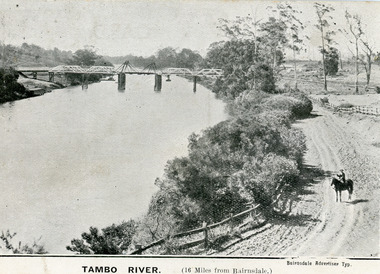
First timber road bridge over the Tambo River at Swan Reach officially opened 20 December 1905, after which punt was removed to BairnsdaleBlack and white postcard of the lifting bridge over the Tambo River at Swan Reach, Victoria. Man on horse standing on dirt road to Metung beside the river. Punt previously used to cross river visible against western bank of river.Tambo River (16 miles from Bairnsdale)bridges, waterways -
 Kiewa Valley Historical Society
Black and white photograph of Surveyor's Camp, 1938, Kiewa River and surveyor's Camp 25/8/38, 25/08/1938
Surveying under the prevailing conditions at this time was an arduous and demanding task. There were no roads beyond Tawonga and access was by bridle tracks, on foot or horseback. This camp was to provide accommodation to those men who were surveying the road from South Tawonga to the Bogong High Plains which was commenced in April, 1938. The actual work was undertaken by the Country Roads Board, on behalf of the State Electricity Commission, using three Caterpillar diesel crawler tractors equipped with Kay Bruneriei (Brunner) lhydraulically operated trailbuilders (angle dozers)This photograph shows the primitive living conditions that were endured by those carrying out the initial field investigations and surveys for the Kiewa Hydro Electric Scheme. It is possibly one of the few photographs in existence of this camp and of the very rustic timber foot bridge across the West Kiewa river. It has been taken from approx. 100m up Simmonds Creek Road. A black and white photograph showing a small, timber foot bridge across the West Kiewa River. There is a man standing on the bridge and two small huts on the far side of the river, against a backdrop of Mt. Beauty and Mt. Bogong.At the top of the photograph, handwritten in black ink is the inscription "Kiewa River and Surveyor's Camp 25/8/38". The number 4 is stamped towards the right upper corner. On the back, in a circle, about 1.3cm in diameter, are the words "Kodak Print". The word "Velox" is faintly discernible on the back as well.surveyor, tawonga, west kiewa river, bridge, camp, secv -
Lakes Entrance Regional Historical Society (operating as Lakes Entrance History Centre & Museum)
Photograph, 1977 c
Polish scientist explorer Dr. Lhotsky explored the Australian Alps south of Mt Kosciusko (not named at that date)as far as McKillops Bridge (unnamed then) between 1834 and 1839. His claims were largely ignored he being labelled imposter and humbug but recent research indicates his rightful place amongst Victorias early explorersBlack and white photograph of Snowy River at Suggan Buggan VictoriaApproximately where John Lhotsky the first white man known to have been in Gippsland reached the Snowy and spent three days in March 1834topography -
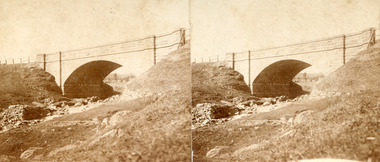
 Clunes Museum
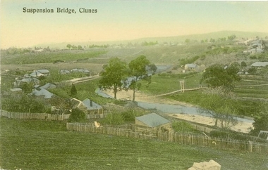
Photograph - POSTCARD, PRINTED IN GERMANY, SUSPENSION BRIDGE, CLUNES
THE SUSPENSION BRIDGE OVER CRESWICK CREEK, PLACED AT CREEK PARADE CLUNES, WAS WASHED AWAY IN A SEVERE FLOOD.COLOURED PHOTOGRAPH OF SUSPENSION BRIDGE CLUNES. PRODUCED AS A POSTCARD - 2 COPIES. ANOTHER COPY HAS BEEN ENLARGED TO A4 SIZE AND LAMINATED - 760.2SUSPENSION BRIDGE - CLUNESlocal history, document, postcard, bridges -
 Stawell Historical Society Inc
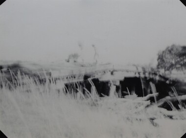
Photograph, Harris Bridge – Red Bend Road -- Great Western
Harris Bridge – Red Bend Road Great Western.Black & white photo of Bridge. Photo is out of focus so hard to work out.Harris' Bridge Red bend Road Great Westernstawell -
 The Beechworth Burke Museum
Photograph - Stereoscopic Photograph, Unknown c1875
Depicted in the photograph is Newtown Bridge or the Newtown Falls Bridge, in Beechworth, Victoria. Noted for its location, detailed craftsmanship and stonemasonry by Scottish stonemasons the Newtown Bridge was built in the 19th century provincial town of Beechworth (completed in 1875). The bridge was built over Spring Creek, spanning 6.3 meters wide and 24.8 meters tall. Beechworth held a distinct role in the administrative and commercial management of Victoria's north-eastern goldfields, with many objects and structures still well preserved from the towns establishment. The bridge indicates the growth of the town, replacing a previous timber structure as well as its association to the mining activity in the area and the rapid increase in Australia's economy that led to investment and development of roads and railways. The local granite used in the construction of the single arch Newtown Bridge makes the bridge and other buildings made with the granite unique to the area, the honey-toned material distinct to Beechworth. This photograph is historically significant as it provides insight into the industrial development of Beechworth and the surrounding area, contributed to by the goldfields. The photograph further captures the representation of vernacular engineering traditions and Scottish stonemasonry.Two sepia-toned rectangular photographs featuring a bridge in the background printed on matte photographic paper mounted on card.Reverse: 97.2324/ Newtown Bridge/ Beechworthbridge, newtown beechworth, newtown bridge, newtown, beechworth, beechworth falls bridge, beechworth mining district, spring creek, -
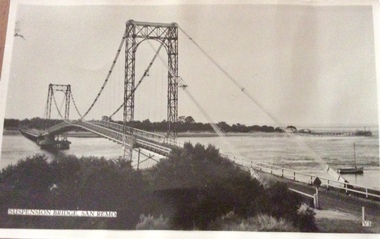 Phillip Island and District Historical Society Inc.
Photograph, Murray Views, Suspension Bridge
First bridge to link Phillip Island to the mainlandBlack & White photo of suspension bridge from San Remo to Newhaven. Taken from San Remo side looking towards NewhavenSuspension Bridge, San Remo V3san remo, newhaven, suspension bridge san remo/phillip island, bridges, photographs -
 Mt Dandenong & District Historical Society Inc.
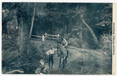
Photograph, Crescent Bridge, Sassafras
The Crescent Bridge in The Crescent at Sassafras. Stories tell us that one of Iris Woolrich’s (nee Dorey) brothers is riding the horse. Photo taken pre WW1.Black and white photograph showing three men, one sitting on a horse, at the Crescent Bridge in SassafrasPrinted on front: Crescent Bridge, Sassafrassassafras, the crescent, woolrich, bridge, track, post card -
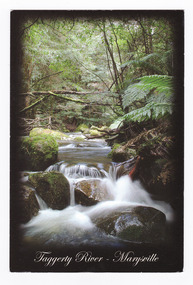 Marysville & District Historical Society
Postcard (item) - Colour postcard, Rosewood Photography, Taggerty River - Marysville, Pre 2009
A colour photograph of the Taggerty River at Marysville in Victoria.A colour photograph of the Taggerty River at Marysville in Victoria. This postcard was produced by Rosewood Photography as a souvenir of Marysville.The Cascading waters of Taggerty River The beautiful & scenic Taggerty River is a 10 minute drive from Marysville, Victoria./ Surrounded by tree ferns & mos covered rocks, the tranquil sounds of the flowing/ river are great place to visit while in Marysville. Photography & Design by/ Roswood Photography/ Mulgrave, Victoria/ [email protected]/ Tel:1300 769 922 Date Stamp 2004/ 6 PM SUNDAY/ Dear Norma & Rod/ All is beauty + peace here/ -the colours are simply/ beautiful every where./ I've done some pleasant/ walking + look forward/ to some more/ Frosty/ mornings perishing - but/ days lovely!!/ Take care - Love-/ Sar-jane A MR + MRS R McDONALD/ 24 PRINCETOWN RD/ MT WAVERLEY/ VIC 3149marysville, taggerty river, victoria, rosewood photography, postcard, souvenir -
 Orbost & District Historical Society
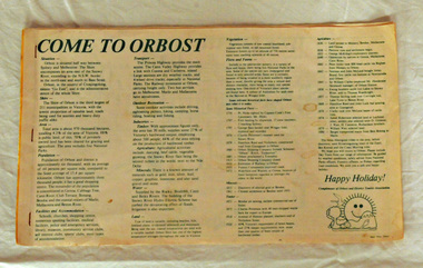
brochure, Come To Orbost, c 1980's
This brochure was produced as a tourist guide to Orbost.This item is a useful research tool.A magazine/brochure for use as tourist information. It contains the history, maps and touring routes of the Orbost district.tourism-orbost -
 Orbost & District Historical Society
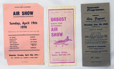
souvenir programs, 1950 ; 1970
Orbost Aero Club began in 1969 with Basil Dowie as Chair, David Nixon as Secretary/Treasurer. The group went into recess from 1977-1991 closing in 1997. The mid 1960s were boom years in flying training in Australia and the number of Aero Clubs grew rapidly. The Club played a significant role in the establishment of the small airport at Marlo and in the ongoing operation and development of the airport over the years particularly for patient transfer by aerial ambulance. The Orbost Aero Club Club played a significant role in the establishment of the small airport at Marlo and in the ongoing operation and development of the airport over the years.Two souvenir programs and one advertising flyer. 2406.27 is a souvenir program for the Orbost Captain Cook Bi-Centenary Air Show 1970. It is purple print on a white background. It has seven folded glossy pages and cost 20c. On the cover is a photograph of a small plane. 2406.28 is a flyer for the Captain Cook Bi-Centenary Air Show, Sunday, April 19th 1970. It is black print on a pink background, 2406.29 is a souvenir program for Morwell Aero Pageant, Monday, January 30, 1950. Cost 3/-. No 4216. It is a grey/brown coloured card folder with black print.2406.28 - on back - Bruce Ham......(?) Yarram Tiger Moth orbost-aero-club captain-cook-bicentenary -
 Orbost & District Historical Society
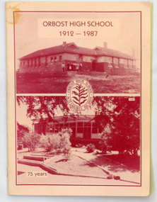
magazines, Orbost High School 1912-1987, 1987
This magazine was produced and published by Orbost High School as a part of the 75 year celabrationsOrbost High School / Orbost Secondary College has played a significant part in the education of senior students in the Orbost district . It is the sole senior educational institution. This magazine is a useful reference tool for the history of the school.Two copies of a 48 pp magazine with a light pink/orange cover. On the front cover is a photo of the Orbost High School. In the centre is the school badge. The text is in maroon print. The book, produced for the 75 year celebration, contains a history of the school, photographs and articles.Inside the front cover of 2415.1 in pen - David F. Nixon 9/2/88education-orbost orbost-high-school -
 Orbost & District Historical Society
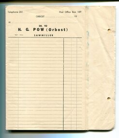
invoice forms, Snowy River Mail as "Mail" Print, 19th century
These invoice forms were to be used by Hector G. Pow's Sawmiller Company in Newmerella ( Henty's & Pow). Pow's had a mill at Cabbage Tree as well. The mill is currently owned by Mectec.Orbost has historically been based on the timber industry, but that industry has declined considerably over the last 20 years. The number of locals involved in the timber industry has declined and many of the mills have closed. This item reflects a time when that industry was a significant contributor to the economy of the district.Unused invoice forms for H.G.Pow Orbost Sawmillers. They are white paper with black print and lines. On the right hand side are two small holes for filing. The page is perforated with carbon underneath to provide two copies - one for filing and one for the customer. At the top of each page is "Telephone 201 Post Office 189 Orbost" and a line for the date. Below this is a line for the customer's name and "Dr to H.G. Pow (Orbost) Sawmiller". There are columns for item descriptions and costs.h.g.pow sawmills timber-orbost -
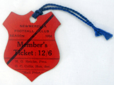 Orbost & District Historical Society
ticket, Snowy River Mail as "Mail" Print, 1956
The official Newmerella Football Club was probably started in 1913. Simon Gargan was the founder of the Newmerella Football Club.Prior to that teams played socially in Orbost and district. This item probably belonged to A. WaitFootball clubs, through their many changes, have always been an important social fabric of the community. Sport is often regarded as an important part of life in rural Australia, contributing to community identity, sense of place, social interaction and good health. A red cardboard shield - shaped ticket with "NEWMERELLA FOOTBALL CLUB member's ticket 1956" on it. It has two blue coloured cord ties.Newmerella Football Club Season 1956 Member's Ticket. N.G. Heinko Pres; G.C. Collis, Hon Sec"newmerella-football-club recreation -
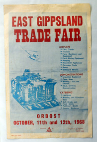 Orbost & District Historical Society
posters and map, Snowy River Mail as "Mail" Print, 1968
This event was held in Orbost near the billabong and present football field.These items are part of a significant event held in Orbost.Two posters with blue background and red and blue print. There is a photograph of a gas rig and helicopter below "EAST GIPPSLAND TRADE FAIR" in red print. Below headings in red print -"Displays, Demonstrations and Catering" are, in black prin,t lists of activities and exhibitions at the fair. At the bottom of the page there is a logo which appeaars to be that of the Electricity Supply Department. In the bottom right corner is "Enquiries to G. Holding" with an Orbost post box number. The date is noted as October, 11th and 12th 1968.east-gippsland-trade-fair