Showing 326 items
matching central planning
-
 Bendigo Historical Society Inc.
Ephemera - LYDIA CHANCELLOR COLLECTION: CORRESPONDENCE
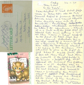
... Council plan to procure The Central Deborah Mine as a tourist... correspondence place Central Deborah Mine gold mines ephemera ...An assortment of articles -(1) 2 Christmas gift cards to Mrs Chancellor, (2) 1 letter card to Mrs Chancellor from Carmel Dillon dated 19th February and, (3) A copy of a letter from Lydia Chancellor dated 22/01/1970 to ' Your views' and 'To the Editor.' The opinion piece is in relation to a Bendigo City Council plan to procure The Central Deborah Mine as a tourist attraction.communication, letters, lydia chancellor collection, correspondence, place, central deborah mine, gold mines, ephemera -
 University of Melbourne, Burnley Campus Archives
Plan, Delysia Westwood, Tree Survey Central Gardens, 1986
... delysia westwood tree survey Central Gardens Numbered plan ...Numbered plan with legend of trees in Central Gardens [Hawthorn]: Height, Diameter, Rating and comments for each tree. Dated November 1986 by Delysia Westwood. Scale 1:500.delysia westwood, tree survey, central gardens -
 Eltham District Historical Society Inc
Photograph - Digital Photograph, Marguerite Marshall, Wingrove Cottage, Main Road, Eltham, 8 June 2006
Wingrove Cottage built 1858-1859 of hand made bricks is historically significant for its long association with Charles Wingrove, a prominent figure in Victorian local government, as secretary to the Eltham District Road Board and Shire Council from 1858 to 1904, and Shire Engineer and Secretary to the Heidelberg Road Board. The cottage was used as the office of the Eltham District Road Board and Council for many years It is one of the Shire's oldest dwellings, and one of the few surviving 19th century buildings associated with early Eltham and located in the original Eltham Village Reserve. The symmetrical planting of a pair of Pencil Pines (not visible in photo) is also historically and aesthetically significant as characteristic of the early period of planting in the district and because they are a distinctive landscape feature. In October 2002 new owners demolished the outbuildings attached to the rear of the cottage. Community protest at the demolition resulted in Council issuing a Stop Work order. The owner was issued with a court order in September 2003 to develop a conservation management plan and restore the heritage listed property. The owner sold the property in 2005 to Cameron Construction in 2005 who undertook the restoration work. In 2007 a planning application to build two offices and seven dwellings at the rear of the property was ultimately rejected. The cottage is now the main office for Cameron Construction. Covered under Heritage Overlay, Nillumbik Planning Scheme. Published: Nillumbik Now and Then / Marguerite Marshall 2008; photographs Alan King with Marguerite Marshall.; p57 Wingrove Cottage on Main Road beside Eltham Primary School, is one of the Shire’s most important historical buildings and was central to local government for almost 50 years. The cottage was built in stages from 1858 to 1888 for Charles Symons Wingrove JP. He was the Eltham District Road Board’s first paid secretary and later the Shire Secretary when the board became the Eltham Shire Council. Wingrove held those positions, and that of engineer for a time, for 46 years. He was also one of the main figures in the Municipal Association of Victoria. As Eltham’s first paid municipal officer, Wingrove used one room in his 11 – (originally two) roomed home, as the office for the board then the council. Meetings were held there from the late 1850s (as well as at more central locations) until Wingrove’s retirement in 1904. The cottage is a rare example of a local government office occupying a Road Board /Shire Secretary’s purpose-designed house. The cottage is also significant because it is the oldest largely intact building from the original Eltham township reserve (south of Dalton Street).1 The township had its origins in the 1848 Nillumbik Parish Plan and was one of the state’s earliest township reserves. The rectangular house of handmade bricks, roofed with grey slate tiles and with a veranda encompassing three sides, is reminiscent of those in the central goldfields including Castlemaine. Its overhanging eaves and gables were unlike houses in Melbourne at the time. Wingrove, who was born in 1827, had been a gold digger and a road surveyor. Impossible to imagine in today’s world, Wingrove was also the Shire of Heidelberg’s secretary and engineer for part of the time that he was secretary in Eltham. Living next door to the primary school was a mixed blessing. Wingrove and his wife Katherine, who had ten children, sent their eight surviving children to the school. But they had occasional disputes with the school authorities when their cattle wandered into the schoolyard. Eltham showed Charles Wingrove its appreciation of his services by giving him two illuminated addresses, one after ten years and the other at retirement. Wingrove died in 1905 aged 76 and was buried in the St Katherine’s Church of England cemetery in St Helena. His grave is surrounded by those of family members including his wife, Katherine and two babies, Henry, 12 months and Isobella, 15 months, who died in the mid-1860s. Cottage ownership passed to his wife, then to daughter Caroline and then to daughter Bessie, a Melbourne University graduate and artist. During the Great Depression their brother Walter was the ratepayer. At one stage the Wingrove property extended to Metery Road and included a small creek. The family ran a small dairy and orchard, with associated farm buildings, which were later removed. In 1949 part of the property was compulsorily acquired by the Eltham Primary School, which infuriated owner Bessie Wingrove. She protested in a letter about this ‘monstrous act of unmitigated tyranny’.2 She was the last Wingrove to occupy the cottage and died in 1955. Wingrove descendants sold the house in 1974 and the property was subdivided. In the 1960s the Eltham Shire named the park opposite the cottage in Wingrove’s honour. The cottage has since had several owners including psychiatrist Dr Daniel Kahans, who practised there. In October 2002 late rear additions which had been substantially altered were demolished contrary to council planning controls. This caused a community outcry and resulted in legal proceedings against the owner. Fortunately the historical significance of the demolished section was not as great as the older front part of the building, which has been retained and was later restored.This collection of almost 130 photos about places and people within the Shire of Nillumbik, an urban and rural municipality in Melbourne's north, contributes to an understanding of the history of the Shire. Published in 2008 immediately prior to the Black Saturday bushfires of February 7, 2009, it documents sites that were impacted, and in some cases destroyed by the fires. It includes photographs taken especially for the publication, creating a unique time capsule representing the Shire in the early 21st century. It remains the most recent comprehenesive publication devoted to the Shire's history connecting local residents to the past. nillumbik now and then (marshall-king) collection, cameron construction, charles symons wingrove, eltham, eltham road district board, eltham shire council, main road, wingrove cottage -
 Eltham District Historical Society Inc
Photograph - Digital Photograph, Marguerite Marshall, St John's Anglican Church, Diamond Creek, 7 September 2008
... in the Gothic Revival style with the traditional rectangular plan... in the Gothic Revival style with the traditional rectangular plan ...The building was designed by Charles Maplestone of Heidelberg, son-in-law to Anthony Beale of St Helena. Maplestone was a prominent architect who came out to Australia with his family in 1852. The foundation stone was laid by Mrs Isabella Maplestone on 11th November 1867. The bricklayers for the church were George Stebbing, H Limmer, H Spicer and a Mr Timm while Thomas Day was the stonemason. Another three years were to pass before sufficient money could be raised for its completion. It was opened by Bishop Perry on 1st November, 1870. The church bell which hung under a tree for 50 years until it was incorporated in the parish hall was brought out from England and presented by Charles Orme. In 1916, the estate of George Martin Pizzey left sufficient money to build the red brick hall, which still stands today (2023) though in January 1969 the hall and bell tower were badly damaged by bushfire. Coincidentally the former home of benefactor, George Pizzey was destroyed in the same fire. Of particular significance are the interior and exterior of the church, the Sunday school and hall with emphasis on pre-World War I fabric (excluding the 1990s additions) and the three coloured glass windows currently suspended in the 1990s entry foyer. In 2011 further alterations were made to the front of the Church. The church is historically significant because it was the oldest public building in the former Diamond Valley Shire, is amongst the oldest buildings in the Shire of Nillumbik and is associated with the early settlement of the Diamond Creek district. The church is historically, socially and spiritually significant because it has been a place of worship for over 150 years and continues to be, an important meeting place in the Shire. The church is aesthetically significant for the three stained glass windows executed by the noted stained glass manufacturers, Ferguson & Urie, as well as the supporting coloured glass windows in the church. The Sunday school & parish hall is architecturally significant because the hall is a well executed and preserved example of the work of noted church architects, North & Williams. It is historically significant because it is connected with local parishioner and Melbourne industrialist, George Pizzey, who bequeathed funds for its construction. Covered under Heritage Overlay, Nillumbik Planning Scheme. National Estate Ntionl Trust of Australia (Victoria) Local significance Published: Nillumbik Now and Then / Marguerite Marshall 2008; photographs Alan King with Marguerite Marshall.; p85 St John’s Anglican Church stands like a beacon on the hill on Main Street, Diamond Creek. Today the church has a large congregation, but its early years were marked by a small congregation struggling to find enough money to survive. It was gold in Diamond Creek that resulted in the building of this National Trust registered property.1 This church is far removed from William Wilson’s humble barn (later the Bowling Green) where the first Anglican church services were conducted – probably the first in the district.2 In the mid 19th century services were infrequent as the Rev Francis Hales, travelling on horseback, also conducted services elsewhere, including at Heidelberg, Coburg, Kinglake, Arthurs Creek, St Andrews and Kangaroo Ground. In 1860 Diamond Creek came under the jurisdiction of the Eltham Parish. Until the mid 1860s the Diamond Creek settlement included only about 20 families who were struggling farmers. But this changed when gold was found in 1862. Then the township grew to 200 families, including miners, civil administration workers and shopkeepers. The resulting growth of Church of England adherents prompted them to petition the Government in 1866 for land to build a church. The area chosen, on which the original building still stands, was at the centre of the proposed township. Today church leaders believe that this conspicuous location is one of the reasons for its exceptional growth. Prominent architect Charles Maplestone designed the building as he did the Presbyterian Church at Kangaroo Ground. St John’s, which is still intact, was built in the Gothic Revival style with the traditional rectangular plan of a central nave and sanctuary at the end. It is typical of small churches built in Victoria at that time, with polychromatic hand-made bricks, a porch, diagonal buttresses and a slate roof.3 The church was officially opened by Lord Bishop Perry on November 1, 1870. But during the next 40 years, due to the varying fortunes of gold mining, the church struggled to remain viable. In 1909 it separated from the Eltham Parish to form a parish with Greensborough. Life became more difficult with the privations of World War One. Then disaster struck in 1915 when fire destroyed the Diamond Creek Gold Mine, wiping out the major livelihood of most parishioners. However the church’s morale was lifted in 1916, when it received a bequest to build the red brick hall, from late parishioner and prominent leather manufacturer, George Pizzey. As prosperity grew, in 1924 the congregation separated from Greensborough, but they rejoined in the 1930s Depression. In the 1950s the wider population soared, impacting on St John’s, and it became a separate parish, becoming responsible for six churches at St Andrews, Hazel Glen, Hurstbridge, St Helena and Yarrambat. As parishioner numbers outgrew the building, extensions were added in 1989 and then in 1993, blending in well with the original building. Church members have made a huge contribution to the local community. John Ryan was a Heidelberg Shire Councillor for 25 years from 1931, Mayor in 1939 and headed several local sporting and other organisations. His son Jock became a clergyman and a local historian heading the Nillumbik Historical Society. Another parishioner, Dr Ted Cordner, came to Diamond Creek in 1920. One of his sons Donald, who was a local doctor, won the Brownlow Medal, was President of the Melbourne Cricket Club and President of the Melbourne Grammar School Council. Roy ‘Monty’ Vale was a state Liberal MP and was related to May Vale, a member of the Heidelberg School of Artists.4 In the early 21st century St John’s Anglican Church is one of the fastest growing congregations in Melbourne. References: St Johns Anglican Church complex, Sunday School and Parish Hall 61 Main Street DIAMOND CREEK, NILLUMBIK SHIRE. (2023, June 7). Retrieved from https://vhd.heritagecouncil.vic.gov.au/places/64023 Diamond Creek, VIC. – St John’s Anglican (2023, June 7). Retrieved from https://www.churchhistories.net.au/church-catalog/diamond-creek-vic-st-johns-anglican This collection of almost 130 photos about places and people within the Shire of Nillumbik, an urban and rural municipality in Melbourne's north, contributes to an understanding of the history of the Shire. Published in 2008 immediately prior to the Black Saturday bushfires of February 7, 2009, it documents sites that were impacted, and in some cases destroyed by the fires. It includes photographs taken especially for the publication, creating a unique time capsule representing the Shire in the early 21st century. It remains the most recent comprehenesive publication devoted to the Shire's history connecting local residents to the past. nillumbik now and then (marshall-king) collection, st john's anglican church, diamond creek -
 Bendigo Historical Society Inc.
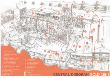
Document - CENTRAL DEBORAH GOLD MINE: PLAN OF SURFACE FEATURES OF MINE
... CENTRAL DEBORAH GOLD MINE: PLAN OF SURFACE FEATURES OF MINE...Two copies of a plan of the Central Deborah Gold Mine... copies of a plan of the Central Deborah Gold Mine. Features ...BHS CollectionTwo copies of a plan of the Central Deborah Gold Mine. Features on the surface of the mine are drawn, labelled and described. Plan printed in orange and grey.bendigo, mining, central deborah gold mine -
 Ringwood and District Historical Society
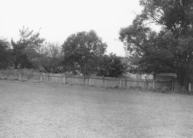
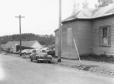
Photograph, Maroondah Highway Central, Ringwood. Buildings at rear of property, N.E. corner of Adelaide Street and Maroondah Highway, 1963. (Eastland Litigation Photo), May 1963
This series of SS0380 photos are part of the "Eastland Litigation" launched in 1962 by the Whitehorse Traders Co-operative Association (WTCA), against the Ringwood Council's Interim Development Order of 1960. WTCA sought "orders from the Supreme Court of Victoria that the planning scheme was invalid" - See "The Eastland Litigation" chapter in "From Horse Shoes to High Heels - Ringwood Shopping Centre and Eastland 1858-2008" by Richard Carter, Bounce Books 2009.Black and White Photograph (2 copies)Written on back of photograph: "Photo showing buildings at rear of property, N.E. corner of Adelaide Street and Maroondah Highway". Stamps on back of photograph read, 'In the Supreme court, 13 Aug. 1963', and 'Edwin G. Adamson....May '63.' -
 Ringwood and District Historical Society
Photograph, Edwin G. Adamson A.R.P.S, Maroondah Highway Central, Ringwood. Looking east from Ringwood Street 1963. (Eastland Litigation Photo), May 1963
This series of SS0380 photos are part of the "Eastland Litigation" launched in 1962 by the Whitehorse Traders Co-operative Association (WTCA), against the Ringwood Council's Interim Development Order of 1960. WTCA sought "orders from the Supreme Court of Victoria that the planning scheme was invalid" - See "The Eastland Litigation" chapter in "From Horse Shoes to High Heels - Ringwood Shopping Centre and Eastland 1858-2008" by Richard Carter, Bounce Books 2009.Black and white photographWritten on back of photograph: "Photo showing cars parked and travelling along M'dah Hway" Stamped on back of photograph, 'Edwin G. Adamson...May 63'. -
 Ringwood and District Historical Society
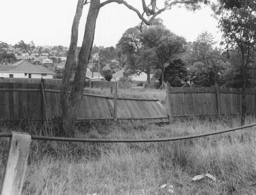
Photograph, Edwin G. Adamson A.R.P.S, Maroondah Highway Central, Ringwood. Vacant land rear of Ringwood Oval 1963 (Eastland Litigation Photo), May 1963
This series of SS0380 photos are part of the "Eastland Litigation" launched in 1962 by the Whitehorse Traders Co-operative Association (WTCA), against the Ringwood Council's Interim Development Order of 1960. WTCA sought "orders from the Supreme Court of Victoria that the planning scheme was invalid" - See "The Eastland Litigation" chapter in "From Horse Shoes to High Heels - Ringwood Shopping Centre and Eastland 1858-2008" by Richard Carter, Bounce Books 2009.Black and white photograph (2 copies)Written on back of photograph: "Photo of the vacant land at rear of oval, i.e. land in private occupation." Stamp on back of photograph, 'Edwin G. Adamson...May 63'. -
 Ringwood and District Historical Society
Photograph, Edwin G. Adamson A.R.P.S, Maroondah Highway Central, Ringwood. Vacant land, rear of the oval, 1963. (Eastland Litigation Photo)
This series of SS0380 photos are part of the "Eastland Litigation" launched in 1962 by the Whitehorse Traders Co-operative Association (WTCA), against the Ringwood Council's Interim Development Order of 1960. WTCA sought "orders from the Supreme Court of Victoria that the planning scheme was invalid" - See "The Eastland Litigation" chapter in "From Horse Shoes to High Heels - Ringwood Shopping Centre and Eastland 1858-2008" by Richard Carter, Bounce Books 2009.Black and White PhotographWritten on back of photograph: "Photo of the vacant back land, rear of oval, i.e. - land in private occupation." Stamped on rear of photograph, 'Edwin G. Adamson...May 63'. -
 Ringwood and District Historical Society
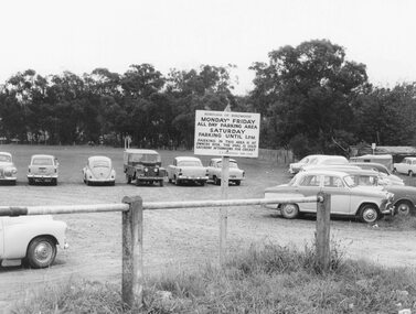
Photograph, Edwin G. Adamson A.R.P.S, Maroondah Highway Central, Ringwood. Ringwood Oval Car Park 1963 (Eastland Litigation Photo), May 1963
This series of SS0380 photos are part of the "Eastland Litigation" launched in 1962 by the Whitehorse Traders Co-operative Association (WTCA), against the Ringwood Council's Interim Development Order of 1960. WTCA sought "orders from the Supreme Court of Victoria that the planning scheme was invalid" - See "The Eastland Litigation" chapter in "From Horse Shoes to High Heels - Ringwood Shopping Centre and Eastland 1858-2008" by Richard Carter, Bounce Books 2009.Black and white photograph (2 copies) Written on back of photograph: "Photo of one of the noticeboards relating to parking on the Oval" Stamp on photograph, 'Edwin G. Adamson...May 63'. -
 Ringwood and District Historical Society
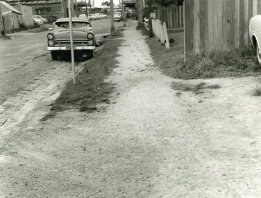
Photograph, Edwin G. Adamson A.R.P.S, Maroondah Highway Central, Ringwood. Adelaide St Footpath - West Side,1963. (Eastland Litigation Photo), May 1963
This series of SS0380 photos are part of the "Eastland Litigation" launched in 1962 by the Whitehorse Traders Co-operative Association (WTCA), against the Ringwood Council's Interim Development Order of 1960. WTCA sought "orders from the Supreme Court of Victoria that the planning scheme was invalid" - See "The Eastland Litigation" chapter in "From Horse Shoes to High Heels - Ringwood Shopping Centre and Eastland 1858-2008" by Richard Carter, Bounce Books 2009.Black and white photograph Written on back of photograph: "Photo of the footpath on West side of Adelaide St, showing how it is unmade and unkempt." Stamp on back of photograph, 'Edwin G. Adamson...May 63'. -
 Ringwood and District Historical Society
Photograph, Edwin G. Adamson A.R.P.S, Maroondah Highway Central, Ringwood. Rear of condemned dwelling NE Corner of Adelaide St,1963. (Eastland Litigation Photo), 1963
This series of SS0380 photos are part of the "Eastland Litigation" launched in 1962 by the Whitehorse Traders Co-operative Association (WTCA), against the Ringwood Council's Interim Development Order of 1960. WTCA sought "orders from the Supreme Court of Victoria that the planning scheme was invalid" - See "The Eastland Litigation" chapter in "From Horse Shoes to High Heels - Ringwood Shopping Centre and Eastland 1858-2008" by Richard Carter, Bounce Books 2009.Black and White PhotographWritten on back of photograph: "Photo showing rear of dwelling of condemned property NE corner of Adelaide St M/dah Hwy. Stamp on back of photo 'Edwin G. Adamson....May 1963'. -
 Bendigo Historical Society Inc.
Document - LANDS OFFICE: CERTIFIED PLAN REGISTER
Document: hard cover journal. Buff cover with embossed edges. Spine has red insert with 'Certified Plan Register' printed in gold. 250 pages, with index in front of register. LH page: number, date of receipt, name, parish, tracing book, plan, decision of Board of land and works, gazette page, name of surveyors, date of survey, sent to, date. RH page: précis of minute. Dated 1878 - 1893, includes areas in central and northern Victoria.plan register, lands office, bendigo, plans, surveyed, victoria, northern victoria -
 Bendigo Historical Society Inc.
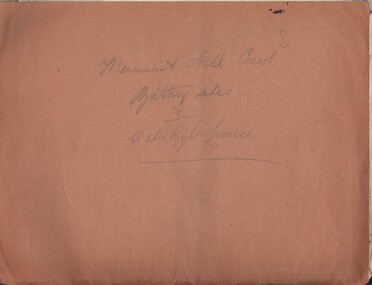
Document - MCCOLL, RANKIN AND STANISTREET COLLECTION: MONUMENT HILL CONSOL. BATTERY SITES & WATER RIGHT LICENCE
Documents: Manilla folder - licences to treat tailings with various plans and notes attached. Various notes - tailings licences Central Nell Gwynne and Monument Hill. Plans for areas applied for on leases 10852, 10166,10423,10238. Plans - area applied for tailings licence applications for leases/water right licences. Prospectus Nell Gwynne(BML) Mines N/L. Various notes relating to above Monument Hill Consol. Battery sites and water right licence.MCCOLL RANKIN & STANISTREETbusiness, gold mining, mccoll rankin & stanistreet, monument hill gold mine, battery, water right -
 Bendigo Historical Society Inc.
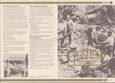
Document - CENTRAL GOLDFIELDS RESTORATION FUND, March 1986
Pamphlet on the Central Goldfields Restoration Fund issued by the Victorian Ministry for Planning and Environment. Includes a map of the central goldfields region, introduction by Jim Kennan (Minister) and 3 photographs. Also a description on how the fund operates and how to apply for assistance. An insert of 2 blank application forms. Photos show , Miners using a sluice at Tarnagulla c.1880. Cnr of Sturt and Lydiard Sts, Ballarat c.1880. E. Eberhard Cordial Factory at Clunes c.1890.Victorian Ministry for Planning and Environmentorganization, government, central goldfields, restoration fund, ministry for planning and environment, j. kennan, tarnagulla, ballarat, clunes. -
 Ballarat Heritage Services
Photograph - Digital Image Daylesford Anglican Church with Bunya Bunya Pine, L.J. Gervasoni, Daylesford Anglican Church with Bunya Bunya Pine, 1987 - 2015
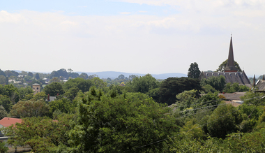
HO664 Hepburn Planning SchemeDigital Images showing the Bunya Bunya pine at the Daylesford Anglican Church over a number of years.anglican, church, daylesford, central springs road, daylesford anglican church, daylesford church of england, bunya bunya pine -
 Ringwood and District Historical Society
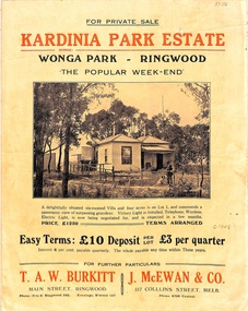
Flyer, Land Sale Brochure, Kardinia Park Estate, North Ringwood, Vic. - circa 1948
Folded buff-coloured land sale advertisement for Kardinia Park Estate in Warranwood area of North Ringwood, including terms of sale, area map, layout plan of the estate, and summary of local facilities and services. Front page features photograph of a man and dog in front of a house captioned as Lot 1 on four acres shown on the estate layout as cnr of Brysons Road and Range View Parade (later Omeo Parade). Second page includes bushland swimming pool photograph and promotional information for prospective buyers.Subdivision includes Kardinia Crescent, Wonga Road, Brysons Road, Range View Parade (later Omeo Parade), Motor Coach Road (later Wonga Park Road, then Warranwood Road). (Agent/s) T.A.W. Burkitt, Main Street, Ringwood, Phone (9 to 6) Ringwood 242, Evenings, Ringwood 157, and J. McEwan & Co, 317 Collins Street, Melbourne, Phone 6750 Central. -
 Ballarat Heritage Services
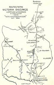
Photograph - Plan, Routes to the Victoria Diggings, 1852
Black and white line drawing of the route to the major Central Victorian Diggings, including Ballarat, Bendigo, Jim Crow (Daylesford), Kyneton, Carlshrue, Mount Macedon, Kilmore, Jackson's Creek, Keilor, Bacchus Marsh, Gregory, Black Forest, Geelong, Flemington, Melbourne, Mount Buninyong, Port Phillip. ballarat, bendigo, jim crow, daylesford, kyneton, carlshrue,, mount macedon, kilmore, jackson's creek, keilor, bacchus marsh, gregory, black forest, geelong, flemington, melbourne, mount buninyong, port phillip, diggings, thomas ham, goldfields -
 Bendigo Historical Society Inc.
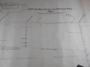
Administrative record - North Red White and Blue and Sheepshead Mine
Draftsman's drawing Central Red, White, and Blue and Sheepshead Mine Map. Forms part of the Margaret Roberts Collection of mining records.Handwritten on plan, Warden's Camp Bendigo Exhibit, Apportion for Forfeiture 8.8.10 (1910) Notes in pencil of measurementsbendigo, margaret roberts, gold, map, mine, north red white blue and sheepshead -
 Melbourne Tram Museum
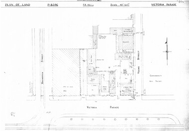
Drawing, Melbourne & Metropolitan Tramways Board (MMTB), "Victoria Parade", "Rae St Fitzroy", c1938
Set of three photocopied plans or drawings on A3 sheet of the "Victoria Parade" and "Rae St Fitzroy", c/1938. .1 - sheet 1 - P8396 - showing layout of buildings, adjacent properties at the intersection of Victoria Parade and Young Street - includes the offices, sub-station and shedding and location of No. 95 Victoria Parade - sheet 2 - P8397 - shows details of No. 95 Victoria Parade and the Two story Traffic offices at the corner of Young and Victoria Parade. .2 - P8405 - Plan of property - block and buildings of No. 449 Rae St Fitzroy. A web search shows that an advertisement was placed for the Carowindra Private Hospital at this location - advertised in the Fitzroy City Press - 14/2/1920 - Trove - access 12-9-2016. This became part of the Central Bus Garage property - see Reg Item 1745.trams, tramways, drawings, depots, property, victoria parade, young st, substation, hospital -
 Melbourne Tram Museum
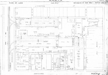
Drawing, Melbourne & Metropolitan Tramways Board (MMTB), "Central Bus Garage", "Nicholson St car shed and repair shops", c1938
Set of four photocopied plans or drawings on A3 sheets of the "Central Bus Garage" and the "Nicholson St car shed and repair shops" .1 - Plan showing block and details of the cable car facilities, repair shops and car paint shop - drawing dated 28-7-1933. .2 - Plan of the block showing the various properties and buildings - shows bus garage location. .3 - South part of drawing No. 1019 - showing the various properties, title details, purchased costs and dates - includes the hospital at Rae St - see Reg Item 1738.2 for details. Dated 8/1940. .4 - North part of the above drawing.trams, tramways, drawings, depots, property, cable trams, nicholson st, central bus garage, buses -
 Melbourne Tram Museum
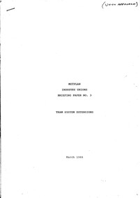
Document - Report, Public transport Unions, "Metplan - Industry Unions - Briefing Paper No. 3 - Tram System Extensions", "Metplan Discussion Paper", 1987 to 1988
Set of four photocopied documents, A4 sheets, stapled in top left hand corner concerning the development and adoption of Metplan, a Metropolitan Public Transport Industry Plan - see Reg Item 1186 for a discussion paper. .1 - "Metplan - Industry Unions - Briefing Paper No. 3 - Tram System Extensions" - March 1988 - 16 sheets - one of series of four documents to give Public Transport Unions where the industry is heading over the 15 years project life period. document looks at the Docklands Light Rail in London and bus services through the Central district of Melbourne. .2 - "Metplan Draft Document - January 1988" - 5 pages - prepared by Martin Gray - December 1987 - looking at training, working conditions, employment security, station staff and service delivery and job opportunities. .3 - "Metplan Discussion Paper" - 3 sheets - gives an overview of the suburban system, union's role, what could be done, electrification, rail cars, station development, dual voltage systems. .4 - "Metplan Discussion Paper" - table looking at the various measures, percentage changes, Metplan issues, services, finance and extension options. See also Reg item 2809 for a August 1988 paper and 345 for a detailed report.trams, tramways, ptc, metplan, unions, buses, tramways, public transport, suburban and underground -
 Melbourne Tram Museum
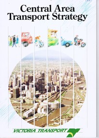
Document - Report, Victoria Transport, "Central Area Transport Study", Mar. 1991
Report - 28 pages + card cover, centre stapled, titled "Central Area Transport Study", produced by Victoria Transport as part of the Central Area Transport Strategy (CATS), with a forward by the Minister for Transport, has a table of contents, figures and tables. Provides a set of Action Plans, looks at future, implementation, options, roads, tram and rail lines, cycle and pedestrians. See Reg Item 471 for a 1988 draft.In ink on top right hand corner "(1991)",trams, tramways, public transport, melbourne, road transport, the met, minister for transport -
Melbourne Tram Museum
Document - Digital Image, Victorian Transport Action Group (VTAG), "Melbourne’s Tram Plan Response Filling the Gaps", March 2024
Document produced by the Victorian Transport Action Group as a response to the Department of Transport "Melbourne Tram Plan" of Oct. 2023 - see item 7364. VTAG have produced a number of initiatives and looks at a number of route proposals that have been made by Government but as of the end of 2024, little progress has been made on any of them. Initiatives suggested are: 1. Confirm its commitment to previously announced projects (listed in Table 1) and provide indicative timeframes for completion. 2. Redirect routes 3, 5 and 12 (detailed in Table 2) with the opening of MM1 to improve the distribution of tram services through the central area. 3. Direct Infrastructure Victoria to undertake the specific planning process as part of the next state infrastructure plan to canvas a range of possible network enhancements. 4. Revise the selection of stops for upgrade to level access to include the practical considerations of technical feasibility and constructability to ensure that as many stops as possible are delivered as a priority. 5. Expand the corridor-based approach being applied to upgrade stops to include the implementation of traffic priority along the selected corridors. 6. Adopt a 15mins, or at least 20 mins, as the maximum headway for all Melbourne tram routes. Notes changes that will be needed as a result of the Melbourne Metro in 2025, tram stops, energy efficiency, renewing the fleet and infrastructure, network performance, and passenger experience. Demonstrates a response to the Vic Govt's tram plan by an Action Group.Digital copy of a 21 A4 page document produced by the Victorian Transport Action Group March 2024. tramways, victorian government, department of transport, planning, vtag -
 Melbourne Tram Museum
Document - Report, Melbourne & Metropolitan Tramways Board (MMTB), 'Current trends which may indicate the future growth and nature of the metropolitan area and in particular the Central Business area of Melbourne", Jan. 1966
Report - Foolscap, card covers, red binding strip, about pages + drawings or charts, titled 'Current trends which may indicate the future growth and nature of the metropolitan area and in particular the Central Business area of Melbourne" Has three parts: 1 - Future growth of population of the Melbourne Metropolitan Area 2 - The Centre of Gravity of and general distribution of the Central Business area of Melbourne 3 - Future growth of the Central Business Area of Melbourne. Dated Jan 1966, prior to the construction of the Underground Railway and the move to Docklands.Has "JEC" in pencil on top right hand corner.trams, tramways, melbourne, planning, development -
 Melbourne Tram Museum
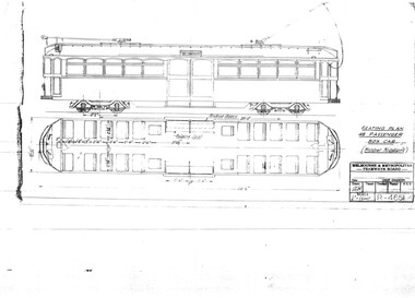
Drawing, Melbourne & Metropolitan Tramways Board (MMTB), "Seating Plan 48 passenger box car (Hopper Windows)", Aug. 1937
... and floor plan of a tramcar like a SW6 but with two large central ...Print of drawing R4661, "Seating Plan 48 passenger box car (Hopper Windows)", showing a side elevation and floor plan of a tramcar like a SW6 but with two large central sliding doors.trams, tramways, sw6 class, bogie trams, new tramcars, tramcar construction, proposals -
 Melbourne Tram Museum
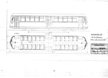
Drawing, Melbourne & Metropolitan Tramways Board (MMTB), "Proposed Box Car", Sep. 1937
Print of drawing R4691, "Proposed Box Car" - with end and central doors, high floor - streamliner approach. Gives side elevation and floor plan.trams, tramways, sw6 class, w5 class, bogie trams, new tramcars, tramcar construction, proposals -
 Melbourne Tram Museum
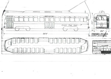
Drawing, Melbourne & Metropolitan Tramways Board (MMTB), "Proposed Box Car", Jan. 1955
Print of drawing R9495, "Proposed Box Car" - with one end and one large central door, high floor - streamliner US PCC approach. Gives side elevation and floor plan. Seats 52 passengers. Prepared 10/1/1955trams, tramways, pcc class, bogie trams, new tramcars, tramcar construction, proposals -
 Melbourne Tram Museum
Document - Report, Graeme Breydon, "Future Development of Tramways in the Melbourne Central Business District", Apr. 1973
Six paged duplicated paper or report titled "Future Development of Tramways in the Melbourne Central Business District", by Graeme Breydon, presented to the AETA 1973 Convention, based on an article prepared for the August 1972 issue of Electric Traction. Has references, looks at proposals for underground part of the Swanston St tramway, alternatives for flinders St and a Yarra crossing, St Kilda Road issues, William St, CBD problems and travel issues, shortcomings of proposals, alternatives, Flinders Gate interchanges, associated track improvements, cost benefit ratios, comments and conclusions. 2nd copy contains within a brown manila quarto sized folded marked "Tramways in the Melbourne. Central Business District" G. Breydon (Aug. 1972). See also Reg Item 3069 and 2812 for further references. .2 - letter - c Jan 1973 - carbon copy of a Letter to the Editor for response to a letter in Electric Traction Dec. 1972 responding to H. Moses and making specific comments. .3 - letter - 29/1/1973 to Graeme Breydon from the Ian Cooper of the AETA responding and accepting an offer of Graeme to present on the Board's plan for the forthcoming AETA Canberra Conference in April 1972. .4 - Report - 17 Quarto pages, stapled on the left hand side titled "Future Development of Melbourne Tramway System, with particular reference to possible improvements to the fixed plant of the Central Business District", written by Graeme Breydon, dated Jan. 1972. Refers to the 1962 report of Risson, and scheme presented to Council, Has hand drawn maps of the central area of Melbourne, Looks at the background, traffic issues, proposed underground loop, employment distribution, an extension to Elisabeth St, reversing loops, St Kilda Road and comments on the MMTB proposals. Refers to a paper delivered by D Lees, MMTB Planning Engineer, Swanston St underground proposal,on outside of the 2nd copy, and on top right hand corner of paper AETA Library mark "4E11"trams, tramways, mmtb, melbourne, traffic control, swanston st, st kilda rd, elizabeth st, bourke st, aeta, transportation, underground tramways -
 Melbourne Tram Museum
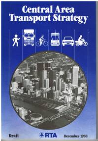
Document - Report, Road Traffic Authority, "Central Area Transport Study", Dec. 1988
Report - 108 pages + card cover, centre stapled, titled "Central Area Transport Study", produced by the Road Traffic Authority as part of the Central Area Transport Strategy (CATS), with a forward by the Minister for Transport Jim Kennan, has a table of contents, figures and tables. Provides a set of Action Plans, looks at future development areas around Melbourne, options, roads, tram and rail lines, cycle and pedestrians. Draft document. See Reg Item 1582 for a March 1991 version.Has pen marks high lighting various paragraphs.trams, tramways, public transport, melbourne, road transport, the met, minister for transport