Showing 750 items matching "chart"
-
 Flagstaff Hill Maritime Museum and Village
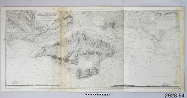
Document - Navigation Chart, Owers to Christchurch with Spithead and the Isle of Wight
British Admiralty Navigation Chart - England - South Coast - Owers to Christchurch with Spithead and the Isle of Wightwarrnambool, shipwrecked-coast, flagstaff-hill, flagstaff-hill-maritime-museum, maritime-museum, shipwreck-coast, flagstaff-hill-maritime-village, shipwrecked-artefact, navigation chart, british admiralty navigation chart, british admiralty, owers to christchurch -
 Flagstaff Hill Maritime Museum and Village
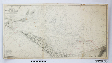
Document - Navigation Chart, Entrance to Port Phillip
British Admiralty Navigation Chart - Australia, Victoria -Entrance to Port Phillip including the Banks and Channels.warrnambool, shipwrecked-coast, flagstaff-hill, flagstaff-hill-maritime-museum, maritime-museum, shipwreck-coast, flagstaff-hill-maritime-village, shipwrecked-artefact, navigation chart, british admiralty navigation chart, british admiralty, entrance to port phillip -
 Flagstaff Hill Maritime Museum and Village
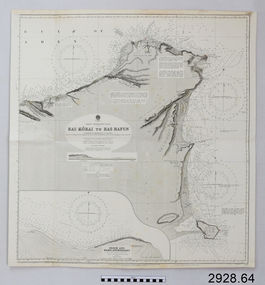
Document - Navigation Chart, Africa - North East Coast - Ras Kòrai to Ras Hafun
British Admiralty Navigation Chart - Africa - North East Coast - Ras Kòrai to Ras Hafunwarrnambool, shipwrecked-coast, flagstaff-hill, flagstaff-hill-maritime-museum, maritime-museum, shipwreck-coast, flagstaff-hill-maritime-village, shipwrecked-artefact, navigation chart, british admiralty navigation chart, british admiralty, ras kòrai to ras hafun, gulf of aden, africa : north east coast -
 Bendigo Military Museum
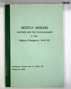
Book, Mostly Unsung. Australia and the Commonwealth in the Malaya Emergency 1948 - 1960, 1989
Soft cover. Green buckram binding. Black printing. Pages 125 Illustrated photos and charts"To Robert with best wishes Roy. 16/7/90" "Donated by P J HOYES'books-military-history, books malaya, books 1948-1960 -
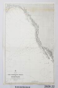 Flagstaff Hill Maritime Museum and Village
Document - Navigation Chart, Cape Cprrientes, Mexico to Kodiak Island
British Admiralty Navigation Chart - North East Pacific - Cape Cprrientes, Mexico to Kodiak Islandwarrnambool, shipwrecked-coast, flagstaff-hill, flagstaff-hill-maritime-museum, maritime-museum, shipwreck-coast, flagstaff-hill-maritime-village, shipwrecked-artefact, british admiralty navigation chart, navigation chart, cape cprrientes,, mexico, kodiak island -
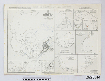 Flagstaff Hill Maritime Museum and Village
Document - Navigation Chart, Plan of Anchorages between Borneo and New Guinea
British Admiralty Navigation Chart - Plan of Anchorages between Borneo and New Guinea with Kayeli Baywarrnambool, shipwrecked-coast, flagstaff-hill, flagstaff-hill-maritime-museum, maritime-museum, shipwreck-coast, flagstaff-hill-maritime-village, shipwrecked-artefact, navigation chart, british admiralty navigation chart, british admiralty -
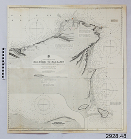 Flagstaff Hill Maritime Museum and Village
Document - Navigation Chart, Africa - North East Coast - Ras Kòrai to Ras Hafun
British Admiralty Navigation Chart - Africa - North East Coast - Ras Kòrai to Ras Hafunwarrnambool, shipwrecked-coast, flagstaff-hill, flagstaff-hill-maritime-museum, maritime-museum, shipwreck-coast, flagstaff-hill-maritime-village, shipwrecked-artefact, navigation chart, british admiralty navigation chart, british admiralty, ras kòrai to ras hafun -
 4th/19th Prince of Wales's Light Horse Regiment Unit History Room
Document, Servicing Schedule for Trucks Utility 3/4 Ton GS FFR Land Rover, Oct 1972
Used by the unit in servicing of vehiclesDocument, 4 pages, stapled detailing the servicing schedule and lubrication chart for the Landrover GS FFRSection 4 Insert No 58 AB 416 (Adapted)landrover, servicing -
 Orbost & District Historical Society
Book - front cover, The Corringle Creek to Sydenham Inlet Coastal Reserve A RESOURCES STUDY, 1977
This 1977 Resources Study was a joint project of the Shire of Orbost & the Dept. of Crown Lands & Survey with the purpose of collating information on natural resources, pattern of public use, and constraints on future use so that management can be formulated.This report gives and understanding of the resources and management directions of coastal land in East Gippsland in 1977. A buff coloured cover with black printing and blue tape binding. 71 pages + maps/charts. THE CORRINGLE CREEK TO SYDENHAM INLET COASTAL RESERVE. A resources study with comment on the implications for management by IAN R. BROWN Research officer and PETER B. LAVERY Land Management Oficer. Coastal management Committee Victoria 1977. Published under the authority of the Coastal Management Committee by the Department of Crown Lands and Survey, Victoria 1977. Printed by James Yeates Printing, Bairnsdale 3875.corringle creek, sydenham inlet, natural resources survey -
Port Melbourne Historical & Preservation Society
Map - Chart, Hobson's Bay, river and navigational aids, 1839 - 1843
On back is handwritten note - Hobson's Bay pp from HMS Beagle 1838-43.Map (Chart) of Hobson's Bay, River and Navigational Aids 1839. (Latrobe Library). in photographic form.melbourne harbor trust - port of melbourne authority, hobson's bay -
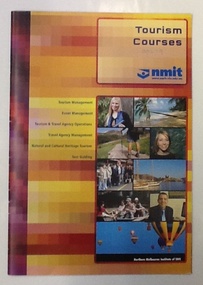 NMIT (Northern Melbourne Institute of TAFE)
Booklet and Brochures - Tourism Courses NMIT 2002-2005, 2005
This booklet outlines courses and career pathways associated with various courses within the NMIT Tourism Department.Booklet of 24 pages of text, colour illustrations and flow charts for 2005; Brochures for 2002 and 2003.tourism, tourism industry, events management, courses, nmit, -
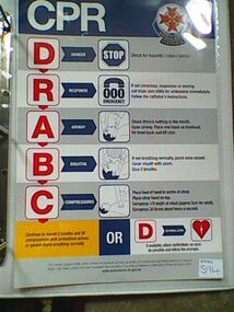 Ambulance Victoria Museum
Chart, CPR, Cira 2007
Gives the five steps required prior to and in attempting to resuscitate patients.A4 sized chart. Ambulance Victoria logo top right side. Written text and diagrams.CPR DANGER RESPONSE AIRWAY BREATHS COMPRESSIONS -
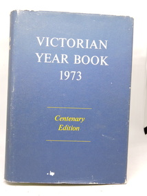 Kilmore Historical Society
Victorian Year Book 1973, Victorian Year Book 1973, Centenary Edition, No. 87, 1973
Centenary Edition traces the major environmental, social, economic, and technological factors which have affected the State of Victoria. Gives an historical perspective of these developments.Hardcover with dust jacket worn at edges. Illustrated, photos, charts. Excellent condition. 1261 pp.'D $6.00" front flyleaf.year book 1973, victoria -
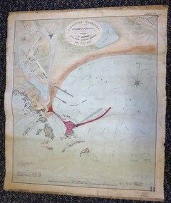 Warrnambool and District Historical Society Inc.
Map - Warrnambool Port 1879, 1879
The port facilities in Warrnambool Bay were in constant use from the first years of Warrnambool’s settlement but there were also difficulties for the shipping trade – a small and unsafe anchorage, the lack of loading facilities and little natural protection from the southerly gales. From the 1870s on there was local agitation for some sort of Breakwater to be built and an Andrew Kerr design was approved by the Warrnambool Council but no funds were made available from the Victorian Government. Throughout the 1870s the building of a Breakwater was a major political issue in the district with preliminary work being funded and started in 1874. In 1879 the Government agreed to a further inspection of the area and an official report. Sir John Coode (1816-1892) was commissioned to make this report. He had come to Australia in 1872 to advise on harbour construction. Coode recommended a 1800 feet long Breakwater and wharf connected to the shore and it was this proposal that the plan described herein and drawn up in 1879 was to accompany. The original plan was eventually modified because of the cost and a Breakwater was completed in 1890 under the direction of the engineer, Arthur Dudley Dobson, with extensions early in the 20th century. This plan is of great interest as it shows in simple graphic form the original plans proposed by Sir John Coode for the Warrnambool Breakwater. It is therefore of great historical importance. The Breakwater was not the maritime success that it was hoped it would be but it is today a significant feature of our foreshore. This is a Plan drawn up in 1879 by Victorian Harbours to accompany Sir John Coode’s Report on the proposed Warrnambool Breakwater. The chart detail is hand-drawn and hand-tinted on canvas with the names of places, geographical and marine features and local points of interest added in print. The edges of the chart are rubbed and the chart is somewhat faded and dirty but the main colours of red, green and brown are still clearly discernible. The title of the plan is printed in an oval inset at the top of the chart. The plan shows two possible Breakwater designs, one from the Borough Surveyor (Andrew Kerr?) and one from Sir John Coode.Victorian Harbours Warrnambool Plan to accompany Sir John Coode’s report Dated 28th Feby 1879 warrnambool breakwater, andrew kerr, sir john coode, arthur dudley dobson, warrnambool, warrnambool harbour, warrnambool history, warrnambool beach -
Southern Sherbrooke Historical Society Inc.
Document - Rainfall records - Belgrave South
-
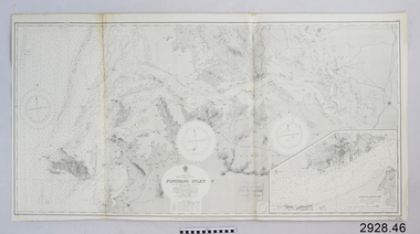
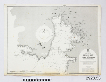 Flagstaff Hill Maritime Museum and Village
Document - Navigation Chart, Sùbic Bay and Port Silanguin
British Admiralty Navigation Chart - Phillipines - Luzom I. - West Coast - Sùbic Bay and Port Silanguinwarrnambool, shipwrecked-coast, flagstaff-hill, flagstaff-hill-maritime-museum, maritime-museum, shipwreck-coast, flagstaff-hill-maritime-village, shipwrecked-artefact, navigation chart, british admiralty navigation chart, british admiralty, phillipines, sùbic bay and port silanguin -
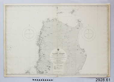 Flagstaff Hill Maritime Museum and Village
Document - Navigation Chart, Luzon Island, North of Latitude 16° 20' north
British Admiralty Navigation Chart - Phillippine Islands - Luzon Island, North of Latitude 16° 20' northwarrnambool, shipwrecked-coast, flagstaff-hill, flagstaff-hill-maritime-museum, maritime-museum, shipwreck-coast, flagstaff-hill-maritime-village, shipwrecked-artefact, navigation chart, british admiralty navigation chart, british admiralty, luzon island -
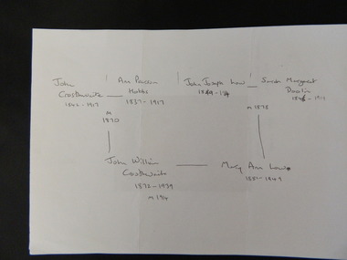 Kiewa Valley Historical Society
Family History - Crosthwaite Family, January 2012
The Crosthwaite family have been long term dairy farmers at Gundowring in the Kiewa Valley.Long term dairy farmers of the Kiewa Valley.Consists of three pages: Handwritten family chart of the Crosthwaite family and two sheets of copies of photos labelled.Labels are handwrittencrosthwaite family; gundowring; kiewa valley -
Federation University Historical Collection
Document - Document - South Australian Institute of Technology, Documents from the South Australian Institute of Technology, 1985; collected by E.J. Barker
E.J. Barker is a past principal of the School of Mines Ballarat and the Library at the Mt Helen Campus is named after him. Document is from the South Australian Institute of Technology re the accreditation of courses and its delegation. Document dated May 1985. Various documents, charts, correspondence collected by E.J. Barker from South Australian Institute of Technology, 1985.e.j. barker, tertiary education authority of south australia, committee of advice, south australian institute of technology, accreditation of courses, accreditation of delegates, committee member, professor connell, terms of reference -
 Flagstaff Hill Maritime Museum and Village
Document - Navigation Chart, Chinnampo Ko, Pingyang Inlet : Yellow Sea, West Coast of Korea
British Admiralty Navigation Chart, Chinnampo Ko, Pingyang Inlet : Yellow Sea, West Coast of Koreawarrnambool, shipwrecked-coast, flagstaff-hill, flagstaff-hill-maritime-museum, maritime-museum, shipwreck-coast, flagstaff-hill-maritime-village, shipwrecked-artefact, navigation chart, british admiralty navigation chart, british admiralty, pingyang inlet, chinnampo ko -
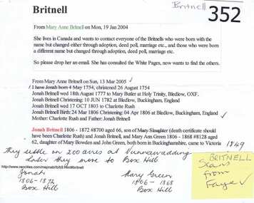 Greensborough Historical Society
Genealogical chart, Britnell Family, 1754o
Details the Britnell families generations from 1806 onwards.Jonah Britnell (b. 1806) was a pioneer of Greensborough and later Box Hill.A 2 1/2 page, Genealogical chart of the Britnell family on A4 page with multi coloured printing.Numerous biro markings and a paragraph in texta pen.britnell family, greensborough, box hill, josiah britnell -
Glenelg Shire Council Cultural Collection
Document - Document - Conversion chart decimals, n.d
Port of Portland Authority Archivesport of portland archives -
 National Wool Museum
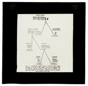
Photograph - Hair Follicles Chart, J W Allen, 1900 - 1940
This item is part of a collection of twenty black and white glass lantern slides previously housed together in an old cardboard box. [8611 - 8630] The slides are part of a greater collection of around forty three black and white glass lantern slides, along with other photographs and photo albums related to this collection. This item is associated with the New South Wales Graziers Association world tour of merino sheep 1928/9. The slides were possibly used as supporting material in presentations made by J W Allen when on tour.Black and white glass lantern slide with paper edging depicting a chart showing variations in hair follicles.new south wales graziers association, travel, cattle, agriculture, j w allen, photography, glass lantern slide -
 Bendigo Historical Society Inc.
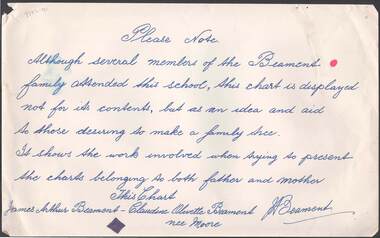
Document - RANDALL COLLECTION: BEAMENT FAMILY TREE
Document, Beament Family Tree, Sign Reads: Please note , although several members of the Beament family attended this school( Gravel Hill School), this chart is not for its contents, but as an idea and aid to those desiring to make a family tree. It shows the work involved when trying to present the charts belonging to both Father and Mother. This Chart, James Arthur Beament - Claudine Olivette Beament nee Moore. Picture on reverse has no name, or to where it might be.bendigo, education, gravel hill primary school -
 Flagstaff Hill Maritime Museum and Village
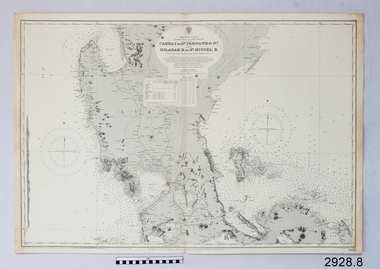
Document - Navigation Chart, Cabra I. to San Fernando Pt and Dilasak B to St. Miguel B
British Admiralty Navigation Chart. Cabra I. to San Fernando Pt and Dilasak B to St. Miguel Bwarrnambool, shipwrecked-coast, flagstaff-hill, flagstaff-hill-maritime-museum, maritime-museum, shipwreck-coast, flagstaff-hill-maritime-village, shipwrecked-artefact, british admiralty navigation chart, navigation chart, cabra i. to san fernando pt and dilasak b to st. miguel b -
 Flagstaff Hill Maritime Museum and Village
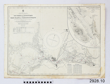
Document - Navigation Chart, California - San Pablo and Suisun Bays including Mare Island and Carquinez straits
British Admiralty Navigation Chart - California - San Pablo and Suisun Bays including Mare Island and Carquinez Straitswarrnambool, shipwrecked-coast, flagstaff-hill, flagstaff-hill-maritime-museum, maritime-museum, shipwreck-coast, flagstaff-hill-maritime-village, shipwrecked-artefact, british admiralty navigation chart, navigation chart, california, suisun bay, san pablo bay, mare island strait, carquinez straitt -
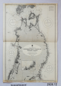 Flagstaff Hill Maritime Museum and Village
Document - Navigation Chart, Japan, Ishinomaki Wan ( Sensai Bay) and Sakata Ko to Tsugaru Kaikyo (Strait)
British Admiralty Navigation Chart -- Japan, Ishinomaki Wan ( Sensai Bay) and Sakata Ko to Tsugaru Kaikyo (Strait)warrnambool, shipwrecked-coast, flagstaff-hill, flagstaff-hill-maritime-museum, maritime-museum, shipwreck-coast, flagstaff-hill-maritime-village, shipwrecked-artefact, british admiralty navigation chart, navigation chart, ishinomaki wan ( sensai bay), sakata ko to tsugaru kaikyo (strait) -
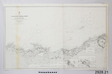 Flagstaff Hill Maritime Museum and Village
Document - Navigation Chart, C. Bougaroni to Fratelli Rocks including the Galita Channel
British Admiralty Navigation Chart - Africa, North Coast - C. Bougaroni to Fratelli Rocks and including The Galita Channelwarrnambool, shipwrecked-coast, flagstaff-hill, flagstaff-hill-maritime-museum, maritime-museum, shipwreck-coast, flagstaff-hill-maritime-village, shipwrecked-artefact, british admiralty navigation chart, navigation chart, c. bougaroni to fratelli rocks including the galita channel -
 City of Moorabbin Historical Society (Operating the Box Cottage Museum)
Document - Genealogy Chart Henry Dendy (Photocopy), 19 thC
In 1840 Henry Dendy, a farmer in Surrey, England acquired a "Special Survey" from the Commissioners for Land and Emigration which gave Dendy the right to choose land in Port Phillip for the "bargain basement" price of only £1 per acre for 5120 acres, (an area of 8 square miles). The Special Survey also included the right to "the shipment of a worker for every £20 spent on land, whose free passage was paid by the Crown, equalling a total of 100 workers ". Accordingly Dendy sold his English holdings and paid the required £5120 and arrived in Melbourne in February 1841. However by this time land in the new colony was selling for £5 - £40 per acre. Because Henry Dendy possessed the order from the Colonial Office in London he was able to successfully oppose Super-intendant LaTrobe's attempts to alter the price of the land. Dendy appointed Jonathan Were, (an entrepreneur, who had arrived in 1839), as his Manager and who later became a partner. Together, Dendy and Were decided on an area 5 miles south from Melbourne, bounded by North Road, East Boundary Road, South Road and to the west by Port Phillip Bay. Were and Dendy pitched their tents in the area now known as ' Park St, Brighton' and sank a well near the corner of 'St Andrew's St and Wells St'. By 1845 J.B Were and Company had bought almost half of Dendy's land and Were built himself "Moorabbin House" in Were St Brighton made from stone, quarried from local cliffs. It was still standing in 1924. Legend records Moorabbin is named after the Aboriginal word for ' Mother's Milk ' The soil is very fertile and well supplied with water especially in the area called 'East Brighton' - now known as Bentleigh and East Bentleigh - By 1850 the area had developed with numerous market gardens, dairy farms, fruit gardens and vineyards supplying food for the growing population of Melbourne.In 1840 Henry Dendy, a farmer in Surrey, England acquired a "Special Survey" from the Commissioners for Land and Emigration which gave Dendy the right to choose land in Port Phillip for the price of only £1 per acre for 5120 acres. This land was called Brighton in the Parish of Moorabbin, County of Bourke and emigrants developed the land establishing market gardens , dairy and poultry farms that provided the food for the growing population of Melbourne. A photocopy of the Genealogy Chart of the Dendy Family that Henry Dendy brought with him when he emigrated to Melbourne 1841Genealogy signs and descriptionsdendy henry, dendy's special survey brighton 1841, governor gipps, captain lonsdale, super-intendant latrobe, port phillip, melbourne, new south wales, squatters, emmigrants, county of bourke, parish of moorabbin, early settlers, pioneers, market gardeners, dairy farmers, fruit farms, moorabbin, bentleigh, brighton, cheltenham, were jonathan binn, -
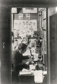 Hume City Civic Collection
Photograph, 1920s
Eric Boardman continued to print the Sunbury News after the death of his father, Arthur, and until the newspaper was taken over by The Regional Group in 1965. Eric Boardman continued to work as a journalist for the paper until his death in 1977.A black and white photograph of a man sitting at a desk working. There are charts on one wall and book shelves facing the man.sunbury news, boardman, eric, arthur, george evans collection