Showing 396 items
matching climbing
-
 Flagstaff Hill Maritime Museum and Village
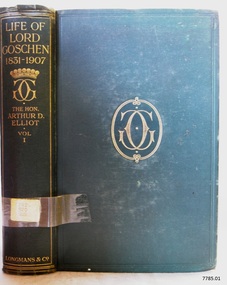
Book - Biography, Arthur D. Elliot, The Life of George Joachim Goschen First Viscount Goschen 1831-1907 Vol 1, 1911
This book is one of two volumes, ‘The Life of George Joachim Goschen First Viscount Goschen 1831-1907’, written by Arthur D. Elliot in 1911. George Joachim Goschen, 1st Viscount Goschen (1831-1907) was a late 19th-century British administrator and economist. He became prominent in financial affairs and at the age of 27 was appointed as a Director of the Bank of England. He was famous for his book, ‘Theory of the Foreign Exchanges’. The book is part of Flagstaff Hill’s Pattison Collection of books which originated from the Warrnambool Mechanics’ Institute. Arthur D. Elliot (1846-1923) wrote ‘in 1911. He was born and educated in England and worked as a politician, a journal editor and an author. His leg was amputated at the age of four after a fall but he was still able to climb, ride and swim. The publisher firm, Longmans, Green & Co, was originally founded in 1724 in London by Thomas Longman under the name Longman. In August of that year, he bought the two shops and goods of William Taylor and set up his publishing house there at 39 Paternoster Row. The shops were called Black Swan and Ship, and it is said that the 'ship' sign was the inspiration for Longman's Logo. After many changes of name and management, the firm was incorporated in 1926 as Longmans, Green & Co. Pty Ltd. The firm was acquired by Pearson in 1968 and was known as Pearson Longman or Pearson PLC. Interestingly, the logo in some books, such as “Steam Turbines 2nd edition, published in 1922” has the year “1724” but the logo in books such as “Advanced Agriculture, published in 1894” has the year “1726” in the logo.The book provides information on the social and political background in England in the late- 19th and early-20th centuries, Which influenced Australia’s history. The book is significant for its connection to the publisher Longmans, Green and Co., of London, a firm that has been established for over two centuries, renowned for publishing encyclopedias, dictionaries, books on English grammar, textbooks, poetry, reference books, novels, magazines and more. The book has additional importance for its connection to the Pattison Collection, which, along with other items at Flagstaff Hill Maritime Village, was originally part of the Warrnambool Mechanics' Institutes’ Collection. The Warrnambool Mechanics’ Institute book collection has historical and social significance for its strong association with the Mechanics Institute movement and its important role in people's intellectual, cultural and social development throughout the latter part of the nineteenth century and the early twentieth century. The collection of books is a rare example of an early lending library and its significance is enhanced by the survival of an original collection of many volumes. The Warrnambool Mechanics' Institute’s publication collection is of both local and state significance.The Life of George Joachim Goschen First Viscount Goschen 1831-1907 Vol 1 Author: Arthur D Elliot Publisher: Longmans Green & Co Date: 1911 Volume 1 of two volumes with illustrations and portraits. The book is part of the Pattison Collection. Green-blue hardcover book with embossed gold text and symbol on the cover and spine. Inscriptions on a label, stickers, stamp and handwriting.Label: "PAT 920 GOS" Sticker: "Warrnambool Mechanics Institute and Free Library" Sticker: "Corangamite Regional Library Service" Stamp: "Corangamite Regional Library Service" Handwriting: "5493/923.2"flagstaff hill, flagstaff hill maritime museum and village, warrnambool, maritime museum, maritime village, great ocean road, shipwreck coast, pattison collection, ralph eric pattison, warrnambool mechanics’ institute, mechanics’ institute library, warrnambool library, free library, corangamite regional library service, longmans green and co., thomas longman, paternoster row london, arthur d. elliot, the life of george joachim goschen first viscount goschen, 1831-1907, george joachim goschen, first viscount goschen -
 Flagstaff Hill Maritime Museum and Village
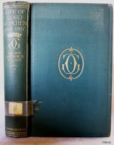
Book - Biography, Arthur D. Elliot, The Life of George Joachim Goschen First Viscount Goschen 1831-1907 Vol 2, 1911
This book is one of two volumes, ‘The Life of George Joachim Goschen First Viscount Goschen 1831-1907’, written by Arthur D. Elliot in 1911. George Joachim Goschen, 1st Viscount Goschen (1831-1907) was a late 19th-century British administrator and economist. He became prominent in financial affairs and at the age of 27 was appointed as a Director of the Bank of England. He was famous for his book, ‘Theory of the Foreign Exchanges’. The book is part of Flagstaff Hill’s Pattison Collection of books which originated from the Warrnambool Mechanics’ Institute. Arthur D. Elliot (1846-1923) wrote ‘in 1911. He was born and educated in England and worked as a politician, a journal editor and an author. His leg was amputated at the age of four after a fall but he was still able to climb, ride and swim. The publisher firm, Longmans, Green & Co, was originally founded in 1724 in London by Thomas Longman under the name Longman. In August of that year, he bought the two shops and goods of William Taylor and set up his publishing house there at 39 Paternoster Row. The shops were called Black Swan and Ship, and it is said that the 'ship' sign was the inspiration for Longman's Logo. After many changes of name and management, the firm was incorporated in 1926 as Longmans, Green & Co. Pty Ltd. The firm was acquired by Pearson in 1968 and was known as Pearson Longman or Pearson PLC. Interestingly, the logo in some books, such as “Steam Turbines 2nd edition, published in 1922” has the year “1724” but the logo in books such as “Advanced Agriculture, published in 1894” has the year “1726” in the logo.The book provides information on the social and political background in England in the late- 19th and early-20th centuries, which influenced Australia’s history. The book is significant for its connection to the publisher Longmans, Green and Co., of London, a firm that has been established for over two centuries, renowned for publishing encyclopedias, dictionaries, books on English grammar, textbooks, poetry, reference books, novels, magazines and more. The book has additional importance for its connection to the Pattison Collection, which, along with other items at Flagstaff Hill Maritime Village, was originally part of the Warrnambool Mechanics' Institutes’ Collection. The Warrnambool Mechanics’ Institute book collection has historical and social significance for its strong association with the Mechanics Institute movement and its important role in people's intellectual, cultural and social development throughout the latter part of the nineteenth century and the early twentieth century. The collection of books is a rare example of an early lending library and its significance is enhanced by the survival of an original collection of many volumes. The Warrnambool Mechanics' Institute’s publication collection is of both local and state significance.The Life of George Joachim Goschen First Viscount Goschen 1831-1907 Vol 2 Author: Arthur D Elliot Publisher: Longmans Green & Co Date: 1911 Volume two of two volumes with illustrations and portraits. The book is part of the Pattison Collection. Green-blue hardcover book with embossed gold text and symbol on the cover and spine. Inscriptions on a label, stickers, stamp and handwriting.Label: "PAT 920 GOS" Sticker "Warrnambool Mechanics Institute and Free Library" Sticker "Corangamite Regional Library Service" Stamp: "Corangamite Regional Library Service" Handwritten "8494 / 923.2"flagstaff hill, flagstaff hill maritime museum and village, warrnambool, maritime museum, maritime village, great ocean road, shipwreck coast, pattison collection, ralph eric pattison, warrnambool mechanics’ institute, mechanics’ institute library, warrnambool library, free library, corangamite regional library service, longmans green and co., thomas longman, paternoster row london, arthur d. elliot, the life of george joachim goschen first viscount goschen, 1831-1907, george joachim goschen, first viscount goschen -
 Eltham District Historical Society Inc
Photograph - Digital Photograph, Alan King, Rob Roy Hill Climb, 24 November 2007
The Rob Roy Hill Climb originated in 1935 on the property of former Heidelberg Mayor, William Clinton, where he reared the Rob Roy breed of miniature ponies. He established Pleasure Grounds on part of the property attracting groups of Sunday visitors from Melbourne's inner suburbs. Visitors enjoyed a picnic area, pony rides, a dance hall and a tap room. Young men would ride their BSA or Harley Davidson motorcycles to the property which led to regular club-organised hillclimb meetings between 1930 and 1936. In 1935 Clinton offered the use of his property to the Light Car Club of Australia for their hillclimbs. The track was sealed that same year and the hillclimb at Clintons Road was one of only three specially designed bitumen surface hillclimbs in the world, the others being Shelsey Walsh and Prescott Hillclimbs in the UK. The first Light Car Club of Australia hillclimb was held at Rob Roy in February 1937. Covered under Heritage Overlay, Nillumbik Planning Scheme. Published: Nillumbik Now and Then / Marguerite Marshall 2008; photographs Alan King with Marguerite Marshall.; p133 About six times a year the unlikely sound of car engines emerges from deep in the heart of Christmas Hills.* Usually a quiet retreat, the Hills are home to one of the world’s oldest purpose-built motor sport venues - the Rob Roy Hillclimb. When sealed in 1939, the hillclimb at Clintons Road was one of only three specially designed bitumen surface hillclimbs in the world, the others being Shelsley Walsh and Prescott Hillclimbs in the UK.1 The Rob Roy Hillclimb originated in 1935 on the property of former Heidelberg mayor, William Clinton, where he reared the Rob Roy breed of miniature ponies. Rob Roy was the Scottish folk hero and outlaw. On part of his property Clinton established Pleasure Grounds, attracting Sunday parties from Melbourne’s inner suburbs. Visitors enjoyed a picnic area, pony rides, a dance hall and a tap room.2 Young men riding on their BSA or Harley Davidson bikes led to club-organised regular hillclimb meetings, between 1930 and 1936. In 1935 Clinton offered his property to the Light Car Club of Australia for their hillclimbs. In February 1937, the first Light Car Club of Australia hillclimb meeting was held at Rob Roy. Jack Day achieved the fastest time that day for the 760 yard (695m) track at 36 seconds in a Ford V8 engined Bugatti Special. At first the climb was just a dusty gravel track, but in 1939 it was up-graded and bituminised. Today the 695 metre track begins on a slight incline, proceeds through a sharp right turn, which formerly passed a rusty iron shed, now remembered by the name Tin Shed Corner. The track continues down a slight incline to a level stretch along the top of an embankment holding back a half-acre (0.2ha) dam, then up to a one-in-three gradient. The track then winds uphill through several left turns to the finish line. In 1939 Frank Kleinig reduced the record to 29.72 seconds in an MG Hudson. Throughout World War Two the Rob Roy Hillclimbs were suspended, but were resumed in 1947. The hillclimbs consistently attracted crowds averaging 500 to 600 people, peaking at 2000, until the hillclimb was destroyed by the 1962 bushfires. The meetings included nine Australian Hillclimb Championships, with the first in 1938 won by Peter Whitehead in his ERA. Eight of the Outright and Class record holders were Australian Grand Prix winners including Jack Brabham, who became a triple F1 World Champion. The Light Car Club of Australia held 61 meetings at Rob Roy. Events usually included Touring, Gran Turismo, Production, Sports, Racing and Vintage cars and in the latter years Go-carts. These meets suddenly stopped after the 1962 bushfire destroyed the access bridge on the property leading to the track area, although fortunately Clinton saved his home. The club then established the Lakeland Hillclimb venue close to Lilydale.3 From 1979 to 1987 the MG Car Club ran hill climbs at the Templestowe Hillclimb until the land was to be sub-divided. In 1991 the MGCC approached the Shire of Nillumbik about using the derelict Rob Roy venue. In 1992, after much lobbying, the club signed a ten-year lease from Melbourne Water, which has been renewed. The original track was faithfully reconstructed. Access roads were improved and guard rails were installed on the causeway. Permanent structures were rebuilt and tonnes of rubbish removed. This was made possible by an immense amount of voluntary work by MGCC members and financial support from the newly formed Friends of Rob Roy. In February 1993 the first Return to Rob Roy Historic Meeting was run with a huge spectator attendance of around 1000 enthusiasts. In September 2007, the Nillumbik Shire Council gave the hillclimb heritage protection. This acknowledged the property’s significant contribution to early Australian motor sport with its social connection to William Clinton and the local community.4 *Christmas Hills was named after emancipated convict and shepherd David Christmas, lost in these hills.This collection of almost 130 photos about places and people within the Shire of Nillumbik, an urban and rural municipality in Melbourne's north, contributes to an understanding of the history of the Shire. Published in 2008 immediately prior to the Black Saturday bushfires of February 7, 2009, it documents sites that were impacted, and in some cases destroyed by the fires. It includes photographs taken especially for the publication, creating a unique time capsule representing the Shire in the early 21st century. It remains the most recent comprehenesive publication devoted to the Shire's history connecting local residents to the past. nillumbik now and then (marshall-king) collection, rob roy hill climb, clintons road, light car club of australia, william clinton -
 Bacchus Marsh & District Historical Society
Photograph, Group of women at a farmhouse near Bacchus Marsh 1883
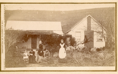
This image is one of several family group portraits taken by Stevenson and McNicoll on rural properties. This property has been identified as that of John Tilley at Parwan’s Creek. The people depicted are presumably members of the Tilley family. The dwelling has since been demolished. Tilleys Road in Maddingley is probably named for this family farm.Small sepia unframed photograph on card with gold border framing photograph. Housed in the Jeremeas Family Album which contains photographs of Bacchus Marsh and District in 1883 by Stevenson and McNicoll. The property has been identified as that of John Tilley at Parwan’s Creek. This property has since been demolished. Presumably, the photo is of members of the Tilley family. The image shows a family group of four women and one young child. It is unclear if the child is a boy or a girl, due to the custom of clothing young male children in dresses. The women are sitting or standing in two groups. To the right stands an older woman in a starched white apron, perhaps indicating that she is the housekeeper. The group on the left is of one woman standing and two women seated, one reading a newspaper or magazine. The young child reaches out one arm to her, perhaps for reassurance. The dwelling consists of two structures, one single storeyed cottage, which is perhaps the older part, and an adjoining weatherboard house with a steeply pitched roof and a prominent chimney at the front. The cottage has a shingled verandah partially covered by corrugated iron, which also covers the roof. Trees, a climbing vine and shrubs form a rather unkempt garden. On the hill rising behind the farmhouse there can be seen animals, possibly sheep, grazing.On the front: Stevenson & McNicoll. Photo. 108 Elizabeth St. Melbourne. COPIES CAN BE OBTAINED AT ANY TIME. On the back: LIGHT & TRUTH inscribed on a banner surmounted by a representation of the rising sun. Copies of this Portrait can be had at any time by sending the Name and Post Office Money Order or Stamps for the amount of order to STEVENSON & McNICOLL LATE BENSON & STEVENSON, Photographers. 108 Elizabeth Street, MELBOURNE. stevenson and mcnicoll 1883 photographs of bacchus marsh and district, farmhouses, families, women bacchus marsh -
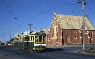
 Melbourne Tram Museum
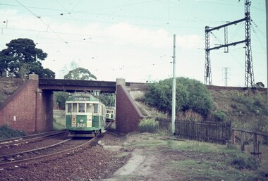
Slide - Set of 9, Keith Caldwell, 17/03/1966 12:00:00 AM
Set of 8 Agfa colour blue white plastic mount slides, photo by Keith Caldwell of trams on the Royal Park line in the vicinity of the Royal Park railway line. .1 - W2 328 (West Coburg Bell St route 55) passing under the railway bridge, with another W2 (362 or 382?) behind. Tram 328 has adverts for Remy Martin and Kleenex tissues. .2 - W2 521, route 55, passing a tram stop. Note the overhead light. .3 -W2 456, route 55 West Coburg via William St, passing under the railway bridge. .4 - not used, .5 - W2 355 with railway bridge in background, Domain Road, Route 56. .6 - W2 506 climbing the hill, Domain Road, route 55. Tram has adverts for White Crow tomato sauce. .7 - W5 812, arriving at stop (Section sign), to Carnegie, route 4. The tram stop has the fares to the city (15d and 7d). In the background is a Perway box. .8 - W2 227 (Domain Road route 56) with the railway station and two other trams in the background. .9 - SW6 (Route 55) outbound with the zoo walls in the background. Tram has advert for Coffey Ford. 17/3/1966In ink "17 iii 66"trams, tramways, royal park, route 55, west coburg, w2 class, domain rd, route 56, w5 class, sw6 class, tram 328, tram 521, tram 456, tram 355, tram 506, tram 812, tram 227, tram 913 -
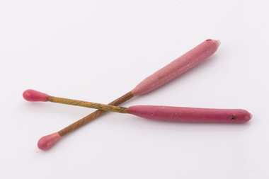 Forests Commission Retired Personnel Association (FCRPA)
Delayed Action Incendiary Device (DAID), Bryant and May - Richmond, Large double ended match
The Forests Commission developed the use of helicopters for aerial ignition from the mid 1960s. Bryant and May at Richmond worked with the Commission to develop a Delayed Action Incendiary Device. DAIDs as the were known, had an overall length of 180 mm, striker end length - 10 mm. Ignition end length - 80 mm, then a layer of high melting point wax (to prevent accidental ignition when rubbing together in transit). Both ends coated with a modified match head compound with safety fuse exposed length between coated match ends. There was a 17-second delay from when the small end was struck to an intense flaming of the large end, which lasted for 40 seconds. DAIDs were dangerous so were stored in a metal box outside the helicopter along with a disposable striker patch attached with a quick release pin to a special half-door. The first test was with a Bell 47G on 4 October 1967 and the first use, anywhere in the world, of DAIDs to backburn a large bushfire was undertaken in north eastern Victoria in February 1968. There was a crash of an FCV helicopter conducting aerial ignition near Wandiligong on 19 April 1978 with the tragic death of two forest officers and their pilot. The crash led to the immediate end of the use of DAIDs and the adoption of the safer Premo ping-pong ball incendiary machine which originally came from Canada but was modified at the Altona workshops. Overall, the development of aerial ignition techniques by the Forests Commission from the mid-1960s resulted in a steady climb in the area burnt each year…. peaking at 477,000 ha in 1980-81 and with an impressive 10-year rolling average of 220,000 ha around the time of 1983 Ash Wednesday Bushfires.Developed in Victoria for aerial ignitionLarge double ended match used for aerial ignition and back burning by dropping from a helicopterbushfire, forests commission victoria (fcv) -
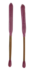 Department of Energy, Environment and Climate Action
Delayed Action Incendiary Device (DAID)
The Forests Commission developed the use of helicopters for aerial ignition from the mid 1960s. Bryant and May at Richmond worked with the Commission to develop a Delayed Action Incendiary Device. DAIDs as the were known, had an overall length of 180 mm, striker end length - 10 mm. Ignition end length - 80 mm, then a layer of high melting point wax (to prevent accidental ignition when rubbing together in transit). Both ends coated with a modified match head compound with safety fuse exposed length between coated match ends. There was a 17-second delay from when the small end was struck to an intense flaming of the large end, which lasted for 40 seconds. DAIDs were dangerous so were stored in a metal box outside the helicopter along with a disposable striker patch attached with a quick release pin to a special half-door. The first test was with a Bell 47G on 4 October 1967 and the first use, anywhere in the world, of DAIDs to backburn a large bushfire was undertaken in north eastern Victoria in February 1968. There was a crash of an FCV helicopter conducting aerial ignition near Wandiligong on 19 April 1978 with the tragic death of two forest officers and their pilot. The crash led to the immediate end of the use of DAIDs and the adoption of the safer Premo ping-pong ball incendiary machine which originally came from Canada but was modified at the Altona workshops. Overall, the development of aerial ignition techniques by the Forests Commission from the mid-1960s resulted in a steady climb in the area burnt each year…. peaking at 477,000 ha in 1980-81 and with an impressive 10-year rolling average of 220,000 ha around the time of 1983 Ash Wednesday Bushfires.Developed in Victoria for aerial ignition by the FCV and Byant & MayLarge double ended match used for aerial ignition and back burning by dropping from a helicopterforests commission victoria (fcv), bushfire, planned burning -
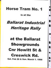 Ballarat Tramway Museum
Memorabilia - Event Materials, BEMPS, "Ballarat's Industrial Heritage Rally - Feb. 1998", 28/06/1998 12:00:00 AM
The following items are associated with the display of Horse Tram No. 1 at the Ballarat Engine and Machinery Preservation Society Rally at the Ballarat Showgrounds on Feb. 28 and Mar. 1, 1998. 807.1 - A4 sheet of paper, printed by BTM on 27/2/1998, advising the horse tram was on display at the showgrounds - used at the depot. 807.2 - A4 sheets of card, printed by BTM on 27/2/1998, advising people to take care when climbing the stairs, and please do not enter signs on reverse, tours on the hours and where queries could be made. Printed by laser printer on yellow card and contained within a plastic display folder. 807.3 - Three copies of the Rally brochure or flier, advertising the Rally at the Showgrounds. Printed mid 1997, on orange paper, phone numbers etc. 807.4 - A4 exhibit sheet for use on the Horse tram at the exhibition. Overprinted by BTM on 28/2/1998. 807.5 - Souvenir Programme - 28 pages plus heavy card covers, 32 pages in all, with index on page 3, list of exhibitors, Ballarat Foundries and Metal Manufacturers listings, Agricultural manufacturers, photographs, advertisements, with colour cover. 807.6 - cast brass rally badge - with organisers name cast on an oval shaped plaque with the words "Ballarat Industrial Heritage Rally" cast under and two figures, a farmer and an miner on either side. Has been stamped No. 64.trams, tramways, souvenir programmes, industrial heritage rally, ballarat manufacturers, ballarat showgrounds -
 Wodonga & District Historical Society Inc
Photograph - Fred Rochow Railways Collection - Historical Special to Cudgewa, 3 November 1963
The Fred Rochow Railways Collection incorporates photos related to the operation of the Wodonga Railway Station including different types of trains and railways staff C. 1930 – 1990. It was donated to the Wodonga Historical Society by Fred Rochow, a railwayman who spent many years based in Wodonga. He joined the Victorian Railways on 17th June l947 and retired in 1988. For some time, he was a member of the Australian Federated Union of Locomotive Enginemen and served a term as a member of the Trades Hall Council. He had an extensive knowledge of the struggles that took place to achieve better conditions for railway workers. Fred worked for many years as a fireman and then worked his way up the ranks to driver, experiencing many changes from the days of steam locomotives through to diesel trains, locomotives and even the modern XPT train. He worked throughout Victoria at different stages of his career, with his final working years focused on the northeast of Victoria and the Albury to Melbourne line. After his retirement, Fred continued to share his love of steam miniature trains with the community. Cudgewa Line -The Cudgewa railway line opened in stages between 1889 and 1921. The first section from Wodonga to Huon opened on 10 September 1889. It was extended to Bolga on 18 July 1890, Tallangatta on 24 July 1891, Shelley on 13 June 1916 (the highest station in Victoria), Beetomba on 10 April 1919 and Cudgewa on 5 May 1921. In 1919, the line was used to carry materials for the construction of Hume Weir, and three years later a spur line connecting Ebden to the weir was opened. In the 1960s, Cudgewa became the railhead of materials for the Snowy Mountains Scheme. The last passenger service from Wodonga to Tallangatta ran on 30 September 1961 The turntable and passenger platform at Cudgewa were abolished in 1976.This collection has local and statewide significance as it captures images of trains, locomotives and personnel who operated the railway services in Wodonga and throughout Northeast Victoria. The railways played a critical role in opening up Victoria and connecting Australia for trade, business, social communication and transport.Historical Steam locomotive on journey to Cudgewa. Locomotive K184 leading with Driver Noel Strauss and Fireman Barrows. Locomotive K186 is the Banker with Driver Doug West. A banker is railway locomotive that temporarily assists a train that requires additional power or traction to climb a gradient. K Class Locomotives - One of VR's most successful classes of loco they were built over a 24 year period. A general purpose, light lines loco the K class had a very long career in all sorts of service from branch line passenger and goods work to pilot and banker duties and roadside mainline service. The K class is credited with working virtually every line in the VR system and hauling almost every kind of train. The majority of the class lasted into the 60's. K 184 and K186 were built by the Victorian Railways' Newport Workshops in 1945 to the successful K-class 2-8-0 locomotive design for branch-line work. K184 entered service on 9 January 1946. K186 entered service on 19 March 1946. K184 was used on heritage services with Steamrail Victoria through the 1970s. It was withdrawn from service in 1980 and is stored at Newport Workshops. and is now used as a source of spare parts; other Steamrail K Class locomotives occasionally wear its number plates and headlight number boards. K186 was scrapped on 25 October 1967.railways wodonga, fred rochow, cudgewa station, high country railway line, k class locomotives -
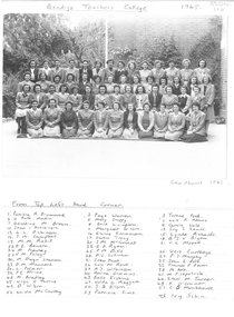 Bendigo Historical Society Inc.
Photograph - LA TROBE UNIVERSITY BENDIGO COLLECTION: BENDIGO TEACHERS' COLLEGE STUDENTS
A black and white photograph of female Bendigo Teachers' College students. It is titled 'Sandhurst 1945'. The women are dressed in the formal fashion of the day in a coat or jacket and skirts or frocks. In the background is a brick building with climbing plants on the walls and a garden with bushes and trees on the left-hand side. There appears to be a flagpole in the centre at the back. The names of the students are listed from the top left-hand corner across - Patricia A. Drummond, Faye Warren, Yvonne Ford, V. Ruth Madin, Mary Guppy, Lois R. Adams, Geraldine M. Brown, Enid Livingstone, Carole Vale, Joan I. Hutchinson, Margaret Wilson, Ivy J. James, G.L. Dickinson, Elaine Emmerson, Lynda Richards, J.M. Campbell, Gwen Tracy, B.J.V. Bryan, M.M. Rahill, J.M. McConnell, V.L. Moore, D.E. Benson, E.D. Ryan, M. Frawley, P.M. Ditle, Gert Curthoys, V.M. Foley, P.V. Sullivan, P.J. Murphy, M.Olwyn Stanson, Joan Hunt, Joan E. Dole, D.M. Manners, Lola M. Rowe, Frances P. Dam, L. Palmer, A.J. Wilhinson, M. Holt, P.E. Mirne, Rosina Gimmins, M. M. Fitzpatrick, M. Bradley, Belle Erskine, Ethel M. Turner, Wilga E. Thorne, Valda G. Raggatt, K. O'Connor, D. Wilson, J.D. Ellson, C.G. Monkhouse, Sheila McCarthy, Patricia Sims, Ivy. S Chin. See 3320.100.education, bendigo teachers' college students, tertiary education, teacher training, sandhurst, bendigo teachers' college, ms. j.c. burnett, mr. geoff. pryor, fashion, clothing, costume, patricia a. drummond, faye warren, yvonne ford, v. ruth madin, mary guppy, lois r. adams, geraldine m. brown, enid livingston, carole vale, joan i. hutchinson, margaret wilson, ivy j. james, g.l. dickinson, elaine emmerson, lynda richards, j.m. campbell, gwen tracy, b.j.v. bryan, m.m. rahill, j.m. mcconnell, v.l. moore, d.e. benson, e.d. ryan, m. frawley, p.m. ditle, gert curthoys, v.m. foley, p.v. sullivan, p.j. murphy, m. olwyn stanson, joan hunt, joan e. dole, d. m. manners, lola m. rowe, frances p. dam, l. palmer, a.j. wilkinson, m. holt, p.m. mirne, rosina gimmins, m. fitzpatrick, m. bradley, belle erskine, ethel m. turner, wilga e. thorne, valda g. raggatt, k. o'connor, d. wilson, j.d. ellson, c.g. monkhouse, sheila mccarthy, patricia sims, ivy schin. -
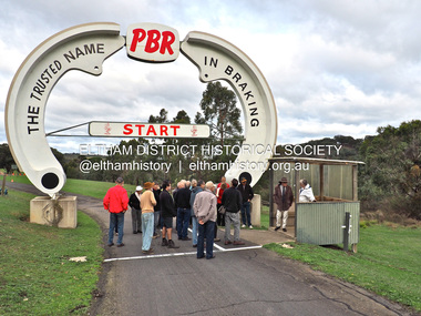 Eltham District Historical Society Inc
Photograph - Digital Photograph, Jim Connor, Rob Roy Hill Climb Circuit, Clintons Road, Christmas Hills, 12 May 2016
Rob Roy-EDHS visit 12 May 2016 On 12th May 2016 some members of the Eltham District Historical Society and others were fortunate to have the opportunity to visit and explore the Rob Roy Hillclimb in Clintons Road, Christmas Hills. This followed an invitation from Don Kinsey and Wayne Ruston, members of the MG Car Club, which operates Rob Roy. At the time, both men were actively involved in the running of the meetings there, Don, an EDHS member, as a course commentator, with a wide range of motorsport experiences, and Wayne as the main organiser of the meetings. Don Kinsey welcomed the group and spoke about the historical background of the property and the hillclimb, then led those interested around the site and up the hillclimb track, stopping at spots along the way to provide additional information. Everyone enjoyed their experiences, including inspecting Wayne Ruston’s MGBV8. The Rob Roy Hill Climb originated in 1935 on the property of former Heidelberg Mayor, William Clinton, where he reared the Rob Roy breed of miniature ponies. He established Pleasure Grounds on part of the property attracting groups of Sunday visitors from Melbourne's inner suburbs. Visitors enjoyed a picnic area, pony rides, a dance hall and a tap room. Young men would ride their BSA or Harley Davidson motorcycles to the property which led to regular club-organised hillclimb meetings between 1930 and 1936. In 1935 Clinton offered the use of his property to the Light Car Club of Australia for their hillclimbs. The track was sealed that same year and the hillclimb at Clintons Road was one of only three specially designed bitumen surface hillclimbs in the world, the others being Shelsey Walsh and Prescott Hillclimbs in the UK. The first Light Car Club of Australia hillclimb was held at Rob Roy in February 1937.jim connor collection, 2016-05-12, activities, christmas hills, clintons road, heritage excursion, rob roy hill climb, eltham district historical society -
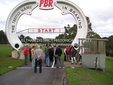 Eltham District Historical Society Inc
Photograph, Fay Bridge, Rob Roy Hill Climb Circuit, Clintons Road, Christmas Hills, 7 September 2013
Rob Roy-EDHS visit 12 May 2016 On 12th May 2016 some members of the Eltham District Historical Society and others were fortunate to have the opportunity to visit and explore the Rob Roy Hillclimb in Clintons Road, Christmas Hills. This followed an invitation from Don Kinsey and Wayne Ruston, members of the MG Car Club, which operates Rob Roy. At the time, both men were actively involved in the running of the meetings there, Don, an EDHS member, as a course commentator, with a wide range of motorsport experiences, and Wayne as the main organiser of the meetings. Don Kinsey welcomed the group and spoke about the historical background of the property and the hillclimb, then led those interested around the site and up the hillclimb track, stopping at spots along the way to provide additional information. Everyone enjoyed their experiences, including inspecting Wayne Ruston’s MGBV8. The Rob Roy Hill Climb originated in 1935 on the property of former Heidelberg Mayor, William Clinton, where he reared the Rob Roy breed of miniature ponies. He established Pleasure Grounds on part of the property attracting groups of Sunday visitors from Melbourne's inner suburbs. Visitors enjoyed a picnic area, pony rides, a dance hall and a tap room. Young men would ride their BSA or Harley Davidson motorcycles to the property which led to regular club-organised hillclimb meetings between 1930 and 1936. In 1935 Clinton offered the use of his property to the Light Car Club of Australia for their hillclimbs. The track was sealed that same year and the hillclimb at Clintons Road was one of only three specially designed bitumen surface hillclimbs in the world, the others being Shelsey Walsh and Prescott Hillclimbs in the UK. The first Light Car Club of Australia hillclimb was held at Rob Roy in February 1937.activities, eltham district historical society, heritage excursion, fay bridge collection, 2016-05-12, christmas hills, clintons road, rob roy hill climb -
 Ballarat Tramway Museum
Photograph - Digital image Set of 10, George Coop, 1968 - 1970
Yields information about the tram operations and the landscape views of the Sturt St median strip.Ten (10) Digital images taken by George Coop during the period 1968 - 1970, of SEC trams in Sturt St, between the City and Pleasant Streets. .1 - Tram 26 climbing the Sturt St hill to Lydiard St, with the Cook's Private Hotel, the Commonwealth Bank and the National Mutual Life building in the background. Photo taken from the Titanic Bandstand. .2 - Tram 40 Sturt St, enough to Lydiard St North just before Raglan St. Has a lady passenger by the tram stop. .3 - Tram 30 - Sturt St north side, near Armstrong St, - has a blue framing line around the photograph. .4 - Tram 39, Sturt St, near Doveton St, shows the rotunda in the median strip. .5 - Tram 18, with median step in view. .6 - Tram 31, with two Johnnie Walker whiskey roof adverts, outside the National Mutual Life building with the Alan Bros Jewellers and Golden Star Chinese Cafe in the view. .7 - Tram 31, Sturt St south side with Town Hall and the Golden City Hotel in the view. Tram has destination of Gardens via Drummond North. .8 - Tram 41 - ditto - going to Sebastopol. .9 - Tram 13, south side, Gardens via Sturt West, about , near Ripon St, with the Ampol service station in the background and about to pick up a lady passenger .10 - Tram 17, near Doveton St. Has a Twin Lakes sign and a Wilkinson Sword Razor Bladese roof advert. trams, tramways, sturt st, raglan st, passengers, doveton st, tram 26, tram 40, tram 30, tram 39, tram 18, tram 31, tram 41, tram 13, tram 17 -
 Ballarat Tramway Museum
Slide - 35mm slide/s - set of 20, Noel Simons, 21/05/1971 12:00:00 AM
Set of 20 transparencies taken on 21/5/1971 on Kodak mounts. 1197.1 - Bendigo No. 5 en route to Eaglehawk at Creeth St Long Gully. Tram has a SEC roof ad and Cinzano roof ad. 1197.2 - No 5 approaching Needle Loop between Long Gully and California Gully. On left hand side is the City of Bendigo sign, indicating city boundary. 1197.3 - As for 1197.2 but actually entering loop. Photo taken after tram has passed photographer. 1197.4 - No. 26 bound for Eaglehawk descending the railway bridge near Eaglehawk, at Jobs Gully. 1197.5 - as for 1197.4, but after crossing bridge, now ascending a hill. Photo taken after tram has passed photographer. 1197.6 - No. 26 climbing High St. hill Eaglehawk, nearing end of Double track, bound for Quarry Hill. Shows centre of the road poles. 1197.7 - As for 1197.6, with tram entering single track section. Photo taken after tram has passed photographer. Has a BP service station in the background. 1197.8 - No. 26 (bound for Quarry Hill) crossing No. 17 (Eaglehawk) at Job's Gully Loop. 1197.9 - No. 17 climbing railway bridge at Job's Gully, en route to Eaglehawk. Photo taken after tram has passed photographer. 1197.10 - No.26 bound for Quarry Hill, leaving Long Gully Loop? Has the Creeth St. church in l197.l in the far background. Photo taken after tram has passed photographer. 1197.11 - Tramway Point work at the northern end of Long Gully Loop. 1197.12 - No. 17 en route for Quarry Hill turning into View St. from Bamard St. Tram has SEC roof ads "Everything fine in my all electric Kitchen' and 'Electric Cooking is Matchless'. 1197.13 - as for 1197.12, but tram has turned into View St and about to enter the double line track. Photo taken after tram has passed photographer. 1197.14 - No. 21 enters Nolan St after turning from MacRae St. en route to Bendigo. Note sign on its own post noting tram turns "Beware Tram Turns" and stop sign on adjacent pole "Trams stop on Request". No. 21 has two SEC roof ads. 1197.15 - No. 21 in Nolan St. after turning from Bridge St. (White Hills Road). Note signal light for Bridge St. loop on pole corner of street. Photo taken after tram has passed photographer. 1197.16 - No. 2 bound for Eaglehawk at unknown location. 1197.17 - Tram stop sign on a pole "CARS STOP BY REQUEST" 1197.18 - No. 5 in Carpenter St.? en route to Quarry Hill. 1197.19 - No. 28 has just arrive at Golden Square terminus, passengers are disembarking and the trolley pole is being turned. Golden Square Hotel in the background. 1197.20 - No. 28 at Golden Square terminus. Has a "Nothing beats Briquettes for hear roof ad. Information written on in black ink and date stamped on purple ink. 1197.1 - "No. 5 at Creeth St. Long Gully" 1197.2 - "No. 5 approaching Needle Loop between Long Gully and California Gully" 1197.3 - "No. 5 at Needle Loop between Long Gully and California Gully" 1197.4 - "No. 26 crossing railway bridge at Job's Gully near Eaglehawk" 1197.5 - "No. 26 just after crossing railway bridge at Job's Gully near Eaglehawk/ 1197.6 - "No. 26 in High St. Eaglehawk" 1197.7 - "No. 26 at end of double track in High St. Eaglehawk" 1197.8 - "Nos. 26 and 17 crossing at Job's Gully Loop" 1197.9 - "No. 17 crossing railway bridge at Job's Gully near Eaglehawk". 1197.10 - "No. 26 at Long Gully" 1197.11 - 'Northern end of points at Long Gully Loop". 1197.12 - "No. 17 turning into View St. from Bamard St. Bendigo". 1197.13 -'No. 17 at beginning of double track in View St. after leaving Bamard St. Bendigo. 1197.14 - "No. 21 enters Nolan St. from MacRae St. Bendigo." 1197.15 - "No. 21 in Nolan St. Bendigo just after leaving White Hills Road." 1197.16 - "No. 2" 1197.18 - "No. 5" 1197.19 - "Birney car No. 28 at Golden Square Terminus" 1197.20 "Birney car No. 28 at Golden Square Terminus" tramways, trams, bendigo, long gully, railway bridge, jobs gully, trackwork, nolan st, quarry hill, tram stops, golden square, tram 2, tram 5, tram 17, tram 21, tram 26, tram 28 -
 Eltham District Historical Society Inc
Photograph, St Andrews Primary School, Eltham Heritage Tour, 24 May 1992, 24/05/1992
ELTHAM HERITAGE TOUR The Society excursion on 24th May 1992 was arranged by David Bick, leader of the team carrying out the Shire's heritage study. David selected a number of sites or buildings identified in the study, some of them lesser known components of the Shire's heritage. The tour commenced at the Eltham Shire Office at 10.00 am. Travel was by private car and mini-bus with stops at about twelve locations for commentary by David.It included a short walk in Hurstbridge and lunch at Kinglake. Highlights of the tour included: - 10 am Leave from Shire Offices - 3 Important Trees - A Physical Link to Eltham's First Settlers - Toorak Mansion Gates - A Surviving Farm House - An Intact Circa 1900 Main Street - First Settlers - Gold Miners, and Timber-getters - An Early Hotel - A Pioneering Homestead - Changing Eltham Shire - 20th Century - 4 pm Afternoon Tea and Finish Tour Extract from ELTHAM CULTURAL HERITAGE TOUR (Newsletter No. 85, July 1992, by Bettina Woodburn) "At St Andrews we noted the old and new schools, the Anglican Church, the Hall, the Bakery and the pub – still a popular watering and eating place. Climbing towards Panton Hill the soil was not rich and supported only scarce growth. Perfunctory prospecting and mining had taken place in this area, though not with the diligence applied at Research. Again we saw the ingredients of a settlement, this one organised by Government, the Hotel, the Store, the School. Down from Memorial Park the School grounds had original tree planting and the School Bell dedicated to Maud Rattray who died in 1922. There is a new Hall and opposite in the grounds of the Church and Sunday School a modest Memorial Cross of granite with inscriptions and in memory of four 'fallen comrades'. This small section of the main road retained the small village atmosphere; although the population had increased there had been little alteration."Record of the Society's history and activities and highlighting various aspects of the Heritage Study undertaken by David Bick used to create the future heritage overlay for the Shire of Eltham and later Nillumbik Shire.Roll of 35mm colour negative film, 4 stripsKodak Gold 100 5095shire of eltham historical society, activities, heritage tour, st andrews -
 Ballarat Tramway Museum
Slide - 35mm slide/s - set of 32, Noel Simons, 25/02/1971 12:00:00 AM
Set of 31 transparencies taken on 25/2/1972 on Kodak mounts. 1201.1 - Bendigo No. 26 in Bond St. just after leaving Long Gully en route for Quarry Hill. Has Norris Supermarket in background. Has two SEC roof ads. 1201.2 - No. 26 climbing View St. from Charing Cross en route to Eaglehawk. Has ANZ bank and AMOCO service station in background. 1201.3 - as for 1201.3, but after tram has passed photographer. Has buildings west of Mackenzie St. in photograph. 1201.4 - Tram stop and centre of the road pole with two "CARS STOP BY REQUEST" signs mounted on pole at the corner of Mackenzie St. 1201.5 - same position as for 1201.3, but with No. 5 descending the street. 1201.6 - same position as for 1201.2, but with No. 5 descending the street. Photo taken after tram has passed photographer. 1201.7 - No. 7 in Nolan St. from across the park at Lake Weeroona. 1201.8 - No. 7 entering McCrae St from Nolan St. - distant view. Note "TRAM "sign on left hand side under tree and overhead in McCrae St. from former track that once was in this street. 1201.9 - No. 7 in High St. with Cathedral in background. Tram en route to North Bendigo. Note scaffolding around Cathedral main spire area. 1201.10 - No. 7 crossing Bendigo Creek bridge in High St. near Golden Square. Has a Caltex Service station in the background. 1201.11 - No. 7 at Golden Square terminus with Sunburst Fruit Juices and a Peters Ice cream delivery vans alongside. 1201.12 - as for 1201.11 but photo taken from behind tram, with the end of the rails in the photograph. 1201.13 - No. 7 and 21 in Pall Mall at Charing Cross with No. 5 in the background. Taken some distance away from the location. 1201.14 - No. 7 at Golden Square terminus, taken a short distance from the tram terminus. Shows Milk Bar on right hand side and the hotel on the left hand side. Taken from the south side of the roadway. 1201.15 - as from 1201.14 but taken from the north side of the roadway. 1201.16 - No 5 waiting at California Gully loop. Distant photo showing surrounds 1201.17 - No. 5 en route for Quarry Hill crossing No. 26 at California Gully. 1201.18 - No. 26 at Eaglehawk terminus with Eaglehawk Town Hall and Post Office in background. 1201.19 - No. 21 arriving at Charing Cross en route to North Bendigo. Has Alexandra Fountain in the background, ANZ bank RACV building, and other buildings on the north side of Pall Mall or Nolan St. 1201.20 - No. 26 en route for Quarry Hill at Charing Cross, with crew standing by front door. Has Colonial Mutual life building, Armstrong Tyre Service (Firestone) and a sign for Cohns Drinks in the background. 1201.21 - as for 1201.20 but with No. 5 en route to Eaglehawk now in photograph. 1201.22 - No. 26 at Quarry Hill terminus. 1201.23 - No. 26 at Quarry Hill terminus, view of front portion of tram only from a gate at the Bendigo cemetery. 1201.24 - Track at the end of the Quarry Hill line showing the point blades of the former "Y" terminus and the overhead for this. 1201.25 - No. 2 at the Quarry Hill terminus, looking along the former Trackwork. 1201.26 - as for 1201.25 1201.27 - number not used. 1201.28 - Golden Square terminus from some distance from the actual terminus, showing the Warning sign "TRAM" for motorists from the south. No. 7 at the terminus. 1201.29 - No. 7 passing through the Golden Square shopping centre. Numerous cars and pedestrians. Tram en route for North Bendigo. 1201.30 - No. 7 in High St. Golden Square, en route for North Bendigo. Photo taken after tram has passed photographer. 1201.31 - No. 7 in High St. just past Wattle St. with the Cathedral in the background. Tram has two SEC roof ads good side on photo, 'Everything's fine in my all electric kitchen' and 'Electrical cooking - clean, quick, economical'. 1201.32 - No. 7 in High St. nearing Wattle St. Has Cathedral in the background. Photo taken after tram has passed photographer.Information written on in black ink and date stamped on purple ink. 1201.1 - "No. 26 in Bond St just after leaving Long Gully" 1201.2 - "No. 26 climbing View St. from Charing Cross" 1201.3 - "No. 26 ascending View St. from Charing Cross (At Mackenzie St.)" 1201.4 - "View St. & Mackenzie St." 1201.5 - "No. 5 in View St. near Mackenzie St." 1201.6 - "No. 5 in View St. nearing Charing Cross." 1201.7 - "No. 7 in Nolan St. seen from Lake Weeroona Park." 1201.8 - "No. 7 entering McRae St. from Nolan St. Note "TRAM" warning sign on left. 1201.9 - "No. 7 in High St. passing Short St." 1201.10 - "No. 7 crossing Bendigo Creek bridge in High St. near Golden Square." 1201.11 - "No. 7 at Golden Square terminus" 1201.12 - "No. 7 at Golden Square terminus" 1201.13 - "No 7, 21 and 5 at Charing Cross" 1201.14 - "No. 7 at Golden Square terminus" 1201.15 - "No. 7 at Golden Square terminus" 1201.16 - "No 5 waiting at California Gully loop." 1201.17 - "Nos. 5 and 26 crossing at California Gully loop" 1201.18 - "No. 26 at Eaglehawk terminus" 1201.19 - "No. 21 arriving at Charing Cross from Golden Square" 1201.20 - "No. 26 at Charing Cross" 1201.21 - "Nos. 5 and 26 at Charing Cross." 1201.22 - "No. 26 at Quarry Hill terminus" 1201.23 - "No. 26 at Quarry Hill terminus seen through the gates of the Bendigo Cemetery." 1201.24 - "Quarry Hill terminus showing remains for former double track layout abandoned before 1964." 1201.25 - "No. 2 at Quarry Hill terminus" 1201.26 - "No. 2 at Quarry Hill terminus" 1201.28 - "The Southern approach to Golden Square with No. 7 standing at the terminus, "TRAM" warning sign on the left. 1201.29 - "No. 7 passing through Golden Square Shopping Centre" 1201.30 - "No. 7 in High St. Golden Square" 1201.31 - "No. 7 in High St. passing Wattle St." 1201.32 - "No. 7 in High St. nearing Wattle St."tramways, trams, bendigo, bond st., view st., nolan st., high st., eaglehawk, california gully, charing cross, quarry hill, trackwork, tram 2, tram 5, tram 7, tram 21, tram 26 -
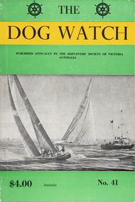 Mission to Seafarers Victoria
Journal (item) - Periodicals-Annual, Shiplovers' Society of Victoria, The Annual Dog Watch
This journal provides the reader with glimpses of the adventures and hardships of a seaman's life. Many of the stories are of sailing ships.Contributes to our knowledge of the importance of shipping and places on record those stories of the sea which would otherwise be lost.Contents Foreword - Senator D. J. Hamer, D.S.C. - 5 Editorial - The Late Joyce M. B. Lambert - 7 Too Short A Life - S. A. E. Strom - 11 P & O's S.S. Canberra -- the Ship of the Falkland Islands War - Illingworth Mackay - 13 Charlie - R. N. Thiele - 31 Of Hobart and "Harriet" - Lloyd Holmes - 33 Our "Edina" - Alex Duffield - 40 At Sea in the "Rona" ("Poly Woodside') - Jack Land - 45 In Future, Rigging Climbing Only - Captain Laurie Gibson - 60 H.M.A.S. "Tingira" - Dudley Ricketts - 65 More than Just A list Of Names - E. Harper - 71 Christmas in a Convoy - Captain Fred Klebingat - 73 The Loss of S.S. "Accoma" A. E. R. & Captain P. J. Elsey - 89 Aboard "Beltana" in '55 - W. P/ Shemmeld - 91 From the Battle of Trafalgar - Lieut. G. W. Hooper, R.N. - 98 Letters from the Ship "Invincible" - Miss Janet Ronald - 100 The Exeter Maritime Museum - T. E. Goldfinch - 110 A Sailor's Diary - The Late J. B. Condor - 112 Book Reviews - - 124sailing ships, steamships, shipping, seafaring life, shiplovers' society of victoria, dog watch -
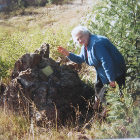 Melton City Libraries
Photograph, The Cairn- Jimmy Melrose's plane crash site, 1988
Edna Barrie at the cairn, photo received from Graeme Minns in 1988. The cairn marks the site of Jimmy Melrose's plane crash in Melton South. The accident which happened on July 5th 1936. In 1934 Melrose made headlines with a series of spectacular flights. In July of that year, he set around Australia record and in that year established a new solo Australia England record when he flew to England to compete in the MacRoberston race with a De Havilland Puss Moth VH- YQO. The only Australian and the only solo pilot to complete the course within the time limit. He was seventh in finishing order and third in the handicap section making news again during the race with a dramatic landing in Darwin with empty fuel tanks. Late in 1935 Melrose imported the Phoenix for his “Adelaide to Anywhere” Charter Service. The previous year the Heston Aircraft Company had taken over the interests of the well known Comper Aircraft Company, and the first production of the new firm was the Phoenix, a single-engined all wooden five seater machine of sesquiplane configuration. The forward half of the fuselage was a streamlined rectangular section and the rear portion was a monocogue shell; the whole was of plywood fabric covered. The wing was built up of spruce box spars and lattice ribs, ply covered from the leading edge to the front spar and the fabric covered over the remainder. The tail surfaces were of similar construction. The most notable feature of the design was the lower stub wing which ran right across the fuselage embodying two box spars, plywood covered it housed the main undercarriage wheels when retracted and provided a substantial anchorage for the Nu form wing struts. The Dowty undercarriage retracted inwards, operated manually by hydraulic packs, Dual control fitted, with side by side seating for the pilots and three passenger seats behind. Power was a 200 h.p. De Havilland Gipsy VI 6 cylinder inverted in-line air-cooled engine. Six Phoenix were built; five of them registered in Great Britain and one of those was later sold abroad the remaining four were impressed into the R.A.F. in 1940. Specifications were: 40 feet 4 inches length 30 ft 2 ins height, 9ft 7ins, wing area 270 sq ft, Tare weight 2,600lbs loaded weight 3,300lbs; cruising speed 360 m.p.h. landing 50mph ceiling 14,000 ft range 700 miles. Melrose’s machine the first production aircraft was built early in 1936 and test flown of the 24th March. Painted green it carries the words “South Australian Centenary 1936” in silver of the fuselage and the name “Billing on the engine cowling in honor of Melrose’s uncle Noel Pemberton Billing, pioneer designer and founder of the Supermarine Aviation Company. The delivery flight was planned as a goodwill mission to publicise the forthcoming South Australian Centenary celebrations. Melrose left Dympne on the 9th April 1936, and flying via Marseilles, Naples, Athens, Baghdad, Basra, Karachi, Jodphur, Calcutta, Akyab, Penang, Singapore, Lombok, Darwin, Newcastle Waters and Alice Springs reached Adelaide on the 25th of April. Continuing the goodwill flight to other States, he visited Melbourne, Sydney, Newcastle, Grafton, Brisbane, Coff’s Harbour, Sydney again, Launceston, Hobart and Mount Gambier before returning to Adelaide on the 13th May. During June Jimmy made some charter flights and early in July was engaged by Mr. A.J. Campbell a director of several mining companies from Melbourne to Darwin to commence at Essendon on the4th July. However on that day low cloud and steady rain caused the postponement. There was little improvement and Melrose was advised to delay the departure again. However he wished to reach Oodnadatta that night, and when he observed the break in the clouds decided to leave. He planned to climb above the cloud and fly to Adelaide at 3,000 feet. The aircraft was airborne about 8.10 a.m. and was last seen from Essendon climbing above the clouds. At 8.45 people at Melton (30 miles West of Melbourne) heard an approaching aircraft. The engine noise increased abnormally and eye witnesses saw the machine fall out of control from the cloud base about 800 feet and then disintegrate, fragments were scattered for 1½ miles and both occupants were killed. Hand written carbon copy by Edna Barrie.Typed by Wendy Barrie March 2014 Last Flight of Jimmy Melrose by John Burke Parade Magazine July 1972 Page 2 –4 This article gives the take off time of 7.50 am from Essendon Airport Eyewitness account at the time Maisie Arthur’s description. Newspaper article. Edna Barrie at the site of the 'Cairn'local identities, local significant events -
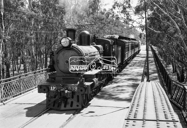 Eltham District Historical Society Inc
Photograph, VR Commissioner's Special train, steam locomotive D3-639 crossing the Echuca-Moama Road Rail Bridge over the Murray River from Moama, NSW to Echuca, Victoria, 1962
VR Commissioner's Special train, steam locomotive D3-639 crossing the Echuca-Moama Road Rail Bridge over the Murray River from Moama, NSW to Echuca, Victoria. Commissioner Edgar Henry Brownbill on footplate, 1962. Commissioner Edgar Henry Brownbill was in office 1957 to 1967. George Coop advises - "The train on the Eltham/Moama bridge is actually the Commissioner’s Special on one of its inspection tours of the VR rail system. This was a very grand special train with accommodation for the Commissioner and staff in carriages also used once for the Royal Train and other State purposes. You can just see the Commissioner of the day, dressed in his suit and wearing engine drivers gloves, standing in the loco cab doorway. A good ‘hands on’ impression is created amongst local staff if can be seen that the boss is no ‘desk jockjey’. The observation car on the back was originally made for the ’Spirit of Progress’. I climbed up onto the bridge iron plate work to get this view. It was safe enough as the cantilevered pedestrian walkway was still on the east side at the time." "I was resident in Echuca from Jan. ’59 to approx. May ’64. At that time the single Echuca/Moama bridge was a combined road/rail bridge. The rail gauge was 5’3” and still is, I believe, on the new bridge that sits just upstream of the old one. This rail line into NSW has always been 5’3" gauge because it has no connection with any NSW tracks. The old Echuca/Moama bridge, locally called the ‘Iron Bridge’ has, over years, undergone some structural changes. The two lattice iron hoops arcing over the roadway have been raised and lowered and changed design. Presently a pedestrian walkway is cantilevered off the west (or downstream) side of the bridge. It used to be on the eastern side. Guess changes went in when new rail bridge only was built on the eastern side as well." Image dated as c.1963 based on same image in Port of Echuca collection (possibly frame 32 of film) (print 19.5 x 24.5cm) On reverse in pencil: "Brown card" in black pen: "Commissioners special. F. Brown on Footplate. George C.L. Coop c1963". https://victoriancollections.net.au/items/59d575b921ea6e1278d78042 However based on frame no. 10, date set as 1962Digital TIFF file Scan of 35mm Ilford FP3 black and white negative transparencyd3-639, d3-class steam locomotive, echuca-moama road rail bridge, edgar henry brownbill, george coop collection, murray river, vr commissioner's special train -
 University of Melbourne, Burnley Campus Archives
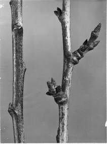
Photograph - Black and white photographs, James (Jim) Pleasance, Pruning Display
Black and white photographs of various sizes pasted on cardboard for display purposes. Some annotated. (1) (2) Difference between leaf and fruit buds. (3) "The 'rod' or whip is most suitable plant to commence training." (4) Planted and pruned fruit tree. "School of Horticulture and Primary Agriculture Burnley B. 1 " stamped on reverse. (5) "Pear Tree-Unpruned (1) June." (6) "Same Pear Tree-Pruned (2) June." (7) Young unpruned "William bon Chretien". Reverse, Burnley Stamp. (8) Same tree pruned. Reverse, Burnley Stamp. (9) Unpruned pear tree. (10) "Narrabben" plum before inserting branch spreaders. (11) With branch spreaders. (12) Close up of some of its branches without spreaders. (13) Close up of branch with seaders. (14) Plum tree with spreaders. (16) Close up of fruiting spurs. (17) "Apple Blossom Oct. Reverse, p 163(Oct." )(18) Same photograph enlarged. (20) Close up of fruiting buds. (21) Old unpruned apricot tree. (22) "Unpruned branch of apricot tree." (23) Close up of apricot branch. (24) "Same branch-apricot-pruned June Reverse, p99 (June)."(25) Pruned branch stump of mature fruit tree.(26) "Clean saw cuts with sharp knife." (27) "Treat all large wounds on trees to avoid infection by wood rotting fungus." (28) "Apply coating of lead paint or grafting mastic." (29) "Branch of lemon-unpruned Aug. Reverse, p157 (Sept.)." (30) "Same branch of lemon-pruned Aug. Reverse, p 157 Aug."(31) "Young climbing rose-ready for planting-July." (32, 33) Grape vine before pruning. (34) Same vine pruned and trained. (35) Older vine pruned.fruit bud, rod, whip, school of horticulture and primary agriculture, burnley, pear tree, spreaders, plum tree, apricot tree, fungus, lead paint, lemon, roses, grape vine, leaf bud, training, fruiting spurs, apple blossom, grafting mastic, teaching, a w jessep -
 4th/19th Prince of Wales's Light Horse Regiment Unit History Room
Order of Ceremony, The Royal Australian Amored (sic) Corps the Keeffe Family & Eoghan McDonald Celebrates (sic) the Unveiling of a Commemorative Plaque 16 November 2014, 2014
The 13th Australian Armoured Regiment was a Gippsland militia unit that had been called up for full time duty in December 1941 as a traditional light horse regiment. The early months of 1942 had seen the regiment lose its horses, a conversion to a motor regiment and finally to an armoured regiment in May. During this period there were considerable changes in personnel, however the regiment maintained its strong links to Gippsland and its former identity. Between May and November 1942, individual soldiers had become proficient in their trade training and the regiment changed its focus to troop and squadron activities. On 16 November 1942, the unit was located at the Puckapunyal Army Camp. C Squadron's training program involved a night driving exercise where a column of armoured and B vehicles would depart camp at 0245 hours and proceed to a site to the East of Seymour and set up a bivouac between Whiteheads Creek and Highlands Road. Numerous army camps surrounded the Seymour area; and much of the surrounding farm land had been acquired for military purposes. By November 1942 exercises such as C Squadron's were commonplace and had been repeated on numerous occasions since 1939. At 0400 hrs, C Squadron's vehicles reached O'Sullivan's Paddock on the Kobyboyn Road; prior to reaching the Old Telegraph Road the column turned to the North towards a known crossing point on Whiteheads Creek. The column consisted of seven M3 Medium Tanks and four Universal Carriers. In the case of Corporal McLeod's vehicle, there were seven crewmen rather than the usual five man crew. On arrival at the creek crossing, Captain C.M.I. 'Sandy' Pearson dismounted and with the assistance of Sergeant R.J. Ball began to guide individual tanks across the creek. Four tanks had crossed the creek without difficulty when Corporal McLeod's tank, ARN 24652, began its descent. Captain Pearson stated at the Coroner's Inquiry in December 1942, "Whilst climbing out of the ford the vehicle swerved to the left, apparently striking the tree. It was not the portion of the tank (front) that struck the tree. The tank straightened and appeared to be well under control, suddenly the bank on the left collapsed to the extent of 3ft by 12ft by15ft long causing the vehicle to slide into the creek and turn upside down." Captain Pearson and Sergeant Ball were faced with a nightmarish situation: The Grant had come to rest upside down in soft mud, six crew members were unaccounted for, escape hatches could not be opened and the weight of the tank was settling deeper into the water and mud. Compounding the problem was that the location of the tank did not allow for the other tanks to safely conduct a recovery. It was truly the darkest night.Single A4 card. folded, Contains an account of the raising of 13 Armoured Regiment in December 1941and a tank accident during a night creek crossing in which six crewmen were killed, and, Order of Ceremony for plaque unveiling, Guest of Honour LtCol Stuart Cree CO/CI School of Armour13 armored regiment, tank accident, puckapunyal -
 Flagstaff Hill Maritime Museum and Village
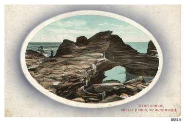
Postcard - Scenic, Warrnambool, Titan Bridge, Shelly Beach, Warrnambool, 1902-1929
The nine postcards in this set were donated together and date to the early 1900s. All but one postcard in this set shows images of Warrnambool, in the Western District of Victoria; the other has a London image. The postcards were all printed in Great Britain according to that country’s postal regulations. The fronts of all cards have titles printed in red. Most of the images on the cards are attributed to photographer Joseph Jordan and belong to the Jordan Series. The back of these cards has an outline for a postage stamp, a vertical dividing line and a heading on each side of the line to separate the Correspondence from the Address. Postcards or ‘correspondence cards’ appeared in Britain in 1894. They were plain cards with a space for the message on one side and an address on the other; regulations didn’t allow anything but the address to be written on the ‘address’ side. In 1902 the British regulations then allowed a picture to be printed on the front and the address on the back, so messages had to be written on the picture side. Soon, the regulations changed and the back was divided for a message and the address. Titan Bridge, Warrnambool – The name Titan Bridge is likely to be a reference to the huge Titan crane that was used in the construction of the Breakwater in the late 19th century. Shelly Beach is a popular swimming area with the added attraction of rock pools to investigate and rock formations to climb. Joseph Jordan - Joseph Jordan was born in 1841 in Leicester England. When he was 16 he joined the 7th Queen's Own Hussars and was sent to India at the outbreak of the mutiny. He took part in the relief of Lucknow and remained in India for eleven years. It was during this time that he became interested in photography. He was posted to New Zealand and later came to Victoria, becoming a sergeant major of the Mounted Rifles. In the mid-1880s he came to the Western district where he was responsible for establishing units of the Mounted Rifles in various country towns such as Dunkeld, Mortlake, Panmure, Bushfield, Koroit etc. He resigned from the army in 1889 and set up a professional photography studio in Liebig Street, Warrnambool. He became very well known in the Western District for family photographs, official photographs of local councillors and groups as well as views of local scenery. In 1891 he photographed the wrecked barque ‘Fiji’ at ‘Wrecks Beach’ near Princetown. His business was taken over by his son Arthur around 1917. Joseph was a keen rifle shot and in 1924 he donated the "Jordan Shield" as a prize to the Victorian Rifle Association. He was made a "Life Honorary Member" of the Warrnambool Returned Soldiers League and in 1933 he was recognised as being the oldest living soldier in Victoria. Joseph died in 1935 aged 95.The image of the Titan Bridge rock formation with figures on it suggests that the location was a popular place to visit. It captures a time when the rock formation was publically accessible. The choice of subject for this postcard indicates the popularity of Warrnambool's natural environment as a tourist attraction at a time when ships called coastal traders brought passengers and cargo to the Port of Warrnambool from ports along Victoria's southwest coast. Joseph Jordan is a significant figure in Warrnambool history as he helped to establish early units of the Mounted Rifles (G Company) in local towns during the late 1880's and later, photographed local scenes, groups and citizens of early Warrnambool.Postcard, one of nine, landscape orientation, coloured print within an oval border and mauve-toned shading. The cameo image shows two figures, one seated and one standing, beside the sea on a rough rock beside a rock formation resembling a bridge. There is no correspondence written on the card. The back has inscriptions and outlines for a postage stamp. Jordan Series, printed in Great Britain.Front, in red: “TITAN BRIDGE / SHELLY BEACH, NEAR WARRNAMBOOL” Back in black: “Jordan Series” “POST CARD” “PRINTED IN GREAT BRITAIN” “For correspondence” “The Address only to be written here”flagstaff hill maritime museum, flagstaff hill maritime village, flagstaff hill maritime museum and village, maritime museum, warrnambool, great ocean road, warrnambool and district, warrnambool scenes, local scenes, views of warrnambool, joseph jordan, jordan series, jordan photography, postcard, souvenir, correspondence, cameo postcard, landscape, shelly beach, titan bridge, titan, rock formation -
 Eltham District Historical Society Inc
Photograph, Murchison Gap, Autumn Excursion, Hume and Hovell's 1824 expedition, 26 May 1996, 26/05/1996
[article by Bettina Woodburn in EDHS Newsletter No. 109, July 1996:] ON THE TRAIL OF HUME AND HOVELL - REPORT ON THE AUTUMN EXCURSION - On a green and fresh morning (Sunday 26th May 1996) the Cobb and Co coach (driven by the most obliging Peter Tampion) set off in a north easterly direction from Eltham to connect with Hume and Hovell's route on their 1824 explorations of central Victoria. The Society would follow a series of monuments erected for the 1924 centenary of the expedition from King Parrot Creek (Tuesday 7th December 1824), through Strath Creek, over Sunday Creek (Sunday 12th December 1824) at Broadford, Tullamarine, St Albans, Deer Park, through Werribee, skirting east of the You Yangs to Lara and Avalon Beach. Because their distance-measuring wheel had broken and a one degree mistake was made in calculations, the two leaders of the original group of six convict-companions arrived at Corio Bay, instead of the expected Western Port, discovered earlier by Flinders. From below Mt. Disappointment (Hume and Hovell's difficulties in "scrambling over brush and rock", "leeches in forest, as well as no water", "cutting grass 4-5 ft. high", dreadful scrub", "devil flies") we took an easier route, saw the Strath Creek memorial in ground fog and a wonderful "field of dreams", the Hume-Hovell privately owned cricket ground with its white picket boundary fence. Now, after a steep climb, in sunshine under gums we stretched and viewed magnificent rolling hills and fog-filled valleys - not "smoke from Aborigines' bush fires". After morning tea at Broadford we followed the Sunday Creek valley beside the Hume Freeway, passed the Wallan Wallan Rest Area (more appropriately Hume and Hovell Rest Area) to tum right at Beveridge. In Gellibrand Hill Park, near the headwaters of the Moonee Ponds Creek, we experienced the landscape the first European settlers saw - huge river red gums and rolling pastures. The gardens and sheltered courtyard of the 1840s, timber, brought from .....[?] prefabricated Woodlands Homestead, provided a pleasant lunch stop. We enjoyed a private tour, panoramic views over Melbourne and surroundings and the excitement of arriving and departing aircraft. Our next river crossing was at Werribee, "in a vast treeless plain", then we drove on by-ways no coach had previously travelled, to find "an immense sheet of water" salty Corio Bay, off-course to the west. In late afternoon of a super, calm, late autumn day we headed homewards. Back at Eltham we were rather surprised to find that we had travelled a total of 347 km. Thanks again to Russell Yeoman for his research and organization. What a wonderful day! Three colour photographsactivities, murchison gap, murchison valley -
 Eltham District Historical Society Inc
Photograph, Hume and Hovell Monument, Broadford, Autumn Excursion, Hume and Hovell's 1824 expedition, 26 May 1996, 26/05/1996
[article by Bettina Woodburn in EDHS Newsletter No. 109, July 1996:] ON THE TRAIL OF HUME AND HOVELL - REPORT ON THE AUTUMN EXCURSION - On a green and fresh morning (Sunday 26th May 1996) the Cobb and Co coach (driven by the most obliging Peter Tampion) set off in a north easterly direction from Eltham to connect with Hume and Hovell's route on their 1824 explorations of central Victoria. The Society would follow a series of monuments erected for the 1924 centenary of the expedition from King Parrot Creek (Tuesday 7th December 1824), through Strath Creek, over Sunday Creek (Sunday 12th December 1824) at Broadford, Tullamarine, St Albans, Deer Park, through Werribee, skirting east of the You Yangs to Lara and Avalon Beach. Because their distance-measuring wheel had broken and a one degree mistake was made in calculations, the two leaders of the original group of six convict-companions arrived at Corio Bay, instead of the expected Western Port, discovered earlier by Flinders. From below Mt. Disappointment (Hume and Hovell's difficulties in "scrambling over brush and rock", "leeches in forest, as well as no water", "cutting grass 4-5 ft. high", dreadful scrub", "devil flies") we took an easier route, saw the Strath Creek memorial in ground fog and a wonderful "field of dreams", the Hume-Hovell privately owned cricket ground with its white picket boundary fence. Now, after a steep climb, in sunshine under gums we stretched and viewed magnificent rolling hills and fog-filled valleys - not "smoke from Aborigines' bush fires". After morning tea at Broadford we followed the Sunday Creek valley beside the Hume Freeway, passed the Wallan Wallan Rest Area (more appropriately Hume and Hovell Rest Area) to tum right at Beveridge. In Gellibrand Hill Park, near the headwaters of the Moonee Ponds Creek, we experienced the landscape the first European settlers saw - huge river red gums and rolling pastures. The gardens and sheltered courtyard of the 1840s, timber, brought from .....[?] prefabricated Woodlands Homestead, provided a pleasant lunch stop. We enjoyed a private tour, panoramic views over Melbourne and surroundings and the excitement of arriving and departing aircraft. Our next river crossing was at Werribee, "in a vast treeless plain", then we drove on by-ways no coach had previously travelled, to find "an immense sheet of water" salty Corio Bay, off-course to the west. In late afternoon of a super, calm, late autumn day we headed homewards. Back at Eltham we were rather surprised to find that we had travelled a total of 347 km. Thanks again to Russell Yeoman for his research and organization. What a wonderful day! Colour photographactivities, broadford, hume and hovell, monument -
 Eltham District Historical Society Inc
Photograph, Hume and Hovell Monument, Autumn Excursion, Hume and Hovell's 1824 expedition, 26 May 1996, 26/05/1996
[article by Bettina Woodburn in EDHS Newsletter No. 109, July 1996:] ON THE TRAIL OF HUME AND HOVELL - REPORT ON THE AUTUMN EXCURSION - On a green and fresh morning (Sunday 26th May 1996) the Cobb and Co coach (driven by the most obliging Peter Tampion) set off in a north easterly direction from Eltham to connect with Hume and Hovell's route on their 1824 explorations of central Victoria. The Society would follow a series of monuments erected for the 1924 centenary of the expedition from King Parrot Creek (Tuesday 7th December 1824), through Strath Creek, over Sunday Creek (Sunday 12th December 1824) at Broadford, Tullamarine, St Albans, Deer Park, through Werribee, skirting east of the You Yangs to Lara and Avalon Beach. Because their distance-measuring wheel had broken and a one degree mistake was made in calculations, the two leaders of the original group of six convict-companions arrived at Corio Bay, instead of the expected Western Port, discovered earlier by Flinders. From below Mt. Disappointment (Hume and Hovell's difficulties in "scrambling over brush and rock", "leeches in forest, as well as no water", "cutting grass 4-5 ft. high", dreadful scrub", "devil flies") we took an easier route, saw the Strath Creek memorial in ground fog and a wonderful "field of dreams", the Hume-Hovell privately owned cricket ground with its white picket boundary fence. Now, after a steep climb, in sunshine under gums we stretched and viewed magnificent rolling hills and fog-filled valleys - not "smoke from Aborigines' bush fires". After morning tea at Broadford we followed the Sunday Creek valley beside the Hume Freeway, passed the Wallan Wallan Rest Area (more appropriately Hume and Hovell Rest Area) to tum right at Beveridge. In Gellibrand Hill Park, near the headwaters of the Moonee Ponds Creek, we experienced the landscape the first European settlers saw - huge river red gums and rolling pastures. The gardens and sheltered courtyard of the 1840s, timber, brought from .....[?] prefabricated Woodlands Homestead, provided a pleasant lunch stop. We enjoyed a private tour, panoramic views over Melbourne and surroundings and the excitement of arriving and departing aircraft. Our next river crossing was at Werribee, "in a vast treeless plain", then we drove on by-ways no coach had previously travelled, to find "an immense sheet of water" salty Corio Bay, off-course to the west. In late afternoon of a super, calm, late autumn day we headed homewards. Back at Eltham we were rather surprised to find that we had travelled a total of 347 km. Thanks again to Russell Yeoman for his research and organization. What a wonderful day! Two colour photographsactivities, hume and hovell, monument -
 Eltham District Historical Society Inc
Photograph, Hume and Hovell Monument, Broadford, Autumn Excursion, Hume and Hovell's 1824 expedition, 26 May 1996, 26/05/1996
[article by Bettina Woodburn in EDHS Newsletter No. 109, July 1996:] ON THE TRAIL OF HUME AND HOVELL - REPORT ON THE AUTUMN EXCURSION - On a green and fresh morning (Sunday 26th May 1996) the Cobb and Co coach (driven by the most obliging Peter Tampion) set off in a north easterly direction from Eltham to connect with Hume and Hovell's route on their 1824 explorations of central Victoria. The Society would follow a series of monuments erected for the 1924 centenary of the expedition from King Parrot Creek (Tuesday 7th December 1824), through Strath Creek, over Sunday Creek (Sunday 12th December 1824) at Broadford, Tullamarine, St Albans, Deer Park, through Werribee, skirting east of the You Yangs to Lara and Avalon Beach. Because their distance-measuring wheel had broken and a one degree mistake was made in calculations, the two leaders of the original group of six convict-companions arrived at Corio Bay, instead of the expected Western Port, discovered earlier by Flinders. From below Mt. Disappointment (Hume and Hovell's difficulties in "scrambling over brush and rock", "leeches in forest, as well as no water", "cutting grass 4-5 ft. high", dreadful scrub", "devil flies") we took an easier route, saw the Strath Creek memorial in ground fog and a wonderful "field of dreams", the Hume-Hovell privately owned cricket ground with its white picket boundary fence. Now, after a steep climb, in sunshine under gums we stretched and viewed magnificent rolling hills and fog-filled valleys - not "smoke from Aborigines' bush fires". After morning tea at Broadford we followed the Sunday Creek valley beside the Hume Freeway, passed the Wallan Wallan Rest Area (more appropriately Hume and Hovell Rest Area) to tum right at Beveridge. In Gellibrand Hill Park, near the headwaters of the Moonee Ponds Creek, we experienced the landscape the first European settlers saw - huge river red gums and rolling pastures. The gardens and sheltered courtyard of the 1840s, timber, brought from .....[?] prefabricated Woodlands Homestead, provided a pleasant lunch stop. We enjoyed a private tour, panoramic views over Melbourne and surroundings and the excitement of arriving and departing aircraft. Our next river crossing was at Werribee, "in a vast treeless plain", then we drove on by-ways no coach had previously travelled, to find "an immense sheet of water" salty Corio Bay, off-course to the west. In late afternoon of a super, calm, late autumn day we headed homewards. Back at Eltham we were rather surprised to find that we had travelled a total of 347 km. Thanks again to Russell Yeoman for his research and organization. What a wonderful day! Colour photographactivities, broadford, hume and hovell, monument -
 Eltham District Historical Society Inc
Photograph, Strath Creek, Autumn Excursion, Hume and Hovell's 1824 expedition, 26 May 1996, 26/05/1996
[article by Bettina Woodburn in EDHS Newsletter No. 109, July 1996:] ON THE TRAIL OF HUME AND HOVELL - REPORT ON THE AUTUMN EXCURSION - On a green and fresh morning (Sunday 26th May 1996) the Cobb and Co coach (driven by the most obliging Peter Tampion) set off in a north easterly direction from Eltham to connect with Hume and Hovell's route on their 1824 explorations of central Victoria. The Society would follow a series of monuments erected for the 1924 centenary of the expedition from King Parrot Creek (Tuesday 7th December 1824), through Strath Creek, over Sunday Creek (Sunday 12th December 1824) at Broadford, Tullamarine, St Albans, Deer Park, through Werribee, skirting east of the You Yangs to Lara and Avalon Beach. Because their distance-measuring wheel had broken and a one degree mistake was made in calculations, the two leaders of the original group of six convict-companions arrived at Corio Bay, instead of the expected Western Port, discovered earlier by Flinders. From below Mt. Disappointment (Hume and Hovell's difficulties in "scrambling over brush and rock", "leeches in forest, as well as no water", "cutting grass 4-5 ft. high", dreadful scrub", "devil flies") we took an easier route, saw the Strath Creek memorial in ground fog and a wonderful "field of dreams", the Hume-Hovell privately owned cricket ground with its white picket boundary fence. Now, after a steep climb, in sunshine under gums we stretched and viewed magnificent rolling hills and fog-filled valleys - not "smoke from Aborigines' bush fires". After morning tea at Broadford we followed the Sunday Creek valley beside the Hume Freeway, passed the Wallan Wallan Rest Area (more appropriately Hume and Hovell Rest Area) to tum right at Beveridge. In Gellibrand Hill Park, near the headwaters of the Moonee Ponds Creek, we experienced the landscape the first European settlers saw - huge river red gums and rolling pastures. The gardens and sheltered courtyard of the 1840s, timber, brought from .....[?] prefabricated Woodlands Homestead, provided a pleasant lunch stop. We enjoyed a private tour, panoramic views over Melbourne and surroundings and the excitement of arriving and departing aircraft. Our next river crossing was at Werribee, "in a vast treeless plain", then we drove on by-ways no coach had previously travelled, to find "an immense sheet of water" salty Corio Bay, off-course to the west. In late afternoon of a super, calm, late autumn day we headed homewards. Back at Eltham we were rather surprised to find that we had travelled a total of 347 km. Thanks again to Russell Yeoman for his research and organization. What a wonderful day! Colour photographactivities, monument, hume and hovell, murchison valley, strath creek -
 Eltham District Historical Society Inc
Photograph, Murchison Gap viewed from Strath Creek, Autumn Excursion, Hume and Hovell's 1824 expedition, 26 May 1996, 26/05/1996
[article by Bettina Woodburn in EDHS Newsletter No. 109, July 1996:] ON THE TRAIL OF HUME AND HOVELL - REPORT ON THE AUTUMN EXCURSION - On a green and fresh morning (Sunday 26th May 1996) the Cobb and Co coach (driven by the most obliging Peter Tampion) set off in a north easterly direction from Eltham to connect with Hume and Hovell's route on their 1824 explorations of central Victoria. The Society would follow a series of monuments erected for the 1924 centenary of the expedition from King Parrot Creek (Tuesday 7th December 1824), through Strath Creek, over Sunday Creek (Sunday 12th December 1824) at Broadford, Tullamarine, St Albans, Deer Park, through Werribee, skirting east of the You Yangs to Lara and Avalon Beach. Because their distance-measuring wheel had broken and a one degree mistake was made in calculations, the two leaders of the original group of six convict-companions arrived at Corio Bay, instead of the expected Western Port, discovered earlier by Flinders. From below Mt. Disappointment (Hume and Hovell's difficulties in "scrambling over brush and rock", "leeches in forest, as well as no water", "cutting grass 4-5 ft. high", dreadful scrub", "devil flies") we took an easier route, saw the Strath Creek memorial in ground fog and a wonderful "field of dreams", the Hume-Hovell privately owned cricket ground with its white picket boundary fence. Now, after a steep climb, in sunshine under gums we stretched and viewed magnificent rolling hills and fog-filled valleys - not "smoke from Aborigines' bush fires". After morning tea at Broadford we followed the Sunday Creek valley beside the Hume Freeway, passed the Wallan Wallan Rest Area (more appropriately Hume and Hovell Rest Area) to tum right at Beveridge. In Gellibrand Hill Park, near the headwaters of the Moonee Ponds Creek, we experienced the landscape the first European settlers saw - huge river red gums and rolling pastures. The gardens and sheltered courtyard of the 1840s, timber, brought from .....[?] prefabricated Woodlands Homestead, provided a pleasant lunch stop. We enjoyed a private tour, panoramic views over Melbourne and surroundings and the excitement of arriving and departing aircraft. Our next river crossing was at Werribee, "in a vast treeless plain", then we drove on by-ways no coach had previously travelled, to find "an immense sheet of water" salty Corio Bay, off-course to the west. In late afternoon of a super, calm, late autumn day we headed homewards. Back at Eltham we were rather surprised to find that we had travelled a total of 347 km. Thanks again to Russell Yeoman for his research and organization. What a wonderful day! Colour photographactivities, hume and hovell, murchison valley, murchison gap, strath creek -
 Eltham District Historical Society Inc
Photograph, Murchison Gap viewed from Strath Creek, Autumn Excursion, Hume and Hovell's 1824 expedition, 26 May 1996, 26/05/1996
[article by Bettina Woodburn in EDHS Newsletter No. 109, July 1996:] ON THE TRAIL OF HUME AND HOVELL - REPORT ON THE AUTUMN EXCURSION - On a green and fresh morning (Sunday 26th May 1996) the Cobb and Co coach (driven by the most obliging Peter Tampion) set off in a north easterly direction from Eltham to connect with Hume and Hovell's route on their 1824 explorations of central Victoria. The Society would follow a series of monuments erected for the 1924 centenary of the expedition from King Parrot Creek (Tuesday 7th December 1824), through Strath Creek, over Sunday Creek (Sunday 12th December 1824) at Broadford, Tullamarine, St Albans, Deer Park, through Werribee, skirting east of the You Yangs to Lara and Avalon Beach. Because their distance-measuring wheel had broken and a one degree mistake was made in calculations, the two leaders of the original group of six convict-companions arrived at Corio Bay, instead of the expected Western Port, discovered earlier by Flinders. From below Mt. Disappointment (Hume and Hovell's difficulties in "scrambling over brush and rock", "leeches in forest, as well as no water", "cutting grass 4-5 ft. high", dreadful scrub", "devil flies") we took an easier route, saw the Strath Creek memorial in ground fog and a wonderful "field of dreams", the Hume-Hovell privately owned cricket ground with its white picket boundary fence. Now, after a steep climb, in sunshine under gums we stretched and viewed magnificent rolling hills and fog-filled valleys - not "smoke from Aborigines' bush fires". After morning tea at Broadford we followed the Sunday Creek valley beside the Hume Freeway, passed the Wallan Wallan Rest Area (more appropriately Hume and Hovell Rest Area) to tum right at Beveridge. In Gellibrand Hill Park, near the headwaters of the Moonee Ponds Creek, we experienced the landscape the first European settlers saw - huge river red gums and rolling pastures. The gardens and sheltered courtyard of the 1840s, timber, brought from .....[?] prefabricated Woodlands Homestead, provided a pleasant lunch stop. We enjoyed a private tour, panoramic views over Melbourne and surroundings and the excitement of arriving and departing aircraft. Our next river crossing was at Werribee, "in a vast treeless plain", then we drove on by-ways no coach had previously travelled, to find "an immense sheet of water" salty Corio Bay, off-course to the west. In late afternoon of a super, calm, late autumn day we headed homewards. Back at Eltham we were rather surprised to find that we had travelled a total of 347 km. Thanks again to Russell Yeoman for his research and organization. What a wonderful day! Colour photographactivities, hume and hovell, murchison valley, murchison gap, strath creek