Showing 1325 items matching "day centre"
-
 Eltham District Historical Society Inc
Photograph - Aerial Photograph, Landata, Lower Plenty, Vic, Apr. 1963
... Centred on present day Old Eltham Road near Araluen Centre... melbourne Centred on present day Old Eltham Road near Araluen Centre ...Centred on present day Old Eltham Road near Araluen Centre, Lower Plenty bounded by Cromwell Street to north, Yarra River to south, Main Road at Mount Pleasant Road to east and Panorama Avenue to west. Historic Aerial Imagery Source: Landata.vic.gov.au Aerial Photo Details: Project No :486 Project : MELBOURNE (1963) PROJECT Run : 7 Frame : 231 Date : 04/1963 Film Type : B/W Camera : RC8 Flying Height : 5100 Scale : 9600 Film Number : 1805 GDA2020 : 37°44'03"S, 145°07'56"E MGA2020 : 335420, 5822027 (55) Melways : 21 F10 (ed. 42)aerial photo, neil webster collection, 1963-04, araluen, cromwell street, eltham, lower plenty, main road, melway 21f10, mount pleasant road, old eltham road, panorama avenue, yarra river -
 Eltham District Historical Society Inc
Photograph - Aerial Photograph, Landata, Eltham, Vic, Apr. 1963
... Centred on present day Eltham Lower Park bounded... melbourne Centred on present day Eltham Lower Park bounded ...Centred on present day Eltham Lower Park bounded by Brougham Street to north, Yarra River and Fitzsimons Lane Bridge to south, Main Road at Kent Hughes Road to east and Bolton Street to west. Historic Aerial Imagery Source: Landata.vic.gov.au Aerial Photo Details: Project No :486 Project : MELBOURNE (1963) PROJECT Run : 7 Frame : 232 Date : 04/1963 Film Type : B/W Camera : RC8 Flying Height : 5100 Scale : 9600 Film Number : 1805 GDA2020 : 37°44'03"S, 145°08'33"E MGA2020 : 336329, 5822040 (55) Melways : 21 H10 (ed. 42)aerial photo, neil webster collection, 1963-04, bolton steet, brougham steet, eltham, eltham lower park, fitzsimons lane bridge, kent hughes road, melway 21h10, yarra river -
 Eltham District Historical Society Inc
Photograph - Aerial Photograph, Landata, Eltham, Vic, Apr. 1963
... Centred on present day Griffith Park Road, Eltham bounded... melbourne Centred on present day Griffith Park Road, Eltham bounded ...Centred on present day Griffith Park Road, Eltham bounded by Mount Pleasant Road to north, Yarra River and Templestowe to south, Main Road at Reynolds Road to east and Falkiner Street to west. Historic Aerial Imagery Source: Landata.vic.gov.au Aerial Photo Details: Project No :486 Project : MELBOURNE (1963) PROJECT Run : 7 Frame : 233 Date : 04/1963 Film Type : B/W Camera : RC8 Flying Height : 5100 Scale : 9600 Film Number : 1805 GDA2020 : 37°44'04"S, 145°09'10"E MGA2020 : 337237, 5822053 (55) Melways : 22 A10 (ed. 42)aerial photo, neil webster collection, 1963-04, eltham, falkiner street, griffith park road, melway 22a10, mount pleasant road, reynolds road, templestowe, yarra river -
 Eltham District Historical Society Inc
Photograph - Aerial Photograph, Landata, Eltham North, Vic, Apr. 1972
... Centred on present day Eltham North reserve near Eltham... melbourne Centred on present day Eltham North reserve near Eltham ...Centred on present day Eltham North reserve near Eltham North Primary School, Eltham North bounded by Allendale Road to north, Bellevue Road to south, Zig Zag Road and Beard Street to east and Ryans Road to west. Historic Aerial Imagery Source: Landata.vic.gov.au Aerial Photo Details: Project No :985 Project : MELBOURNE 1972 Run : 26 Frame : 190 Date : 04/1972 Film Type : B/W Camera : RC10 Flying Height : 5700 Scale : 9600 Film Number : 2636 GDA2020 : 37°41'52"S, 145°08'52"E MGA2020 : 336705, 5826102 (55) Melways : 11 J12 (ed. 42)aerial photo, neil webster collection, 1972-04, allendale road, beard street, bellevue road, eltham, eltham north, eltham north reserve, melway 11j12, ryans road, zig zag road, eltham north primary school -
 Eltham District Historical Society Inc
Photograph - Aerial Photograph, Landata, Eltham, Vic, Apr. 1972
... Centred on present day Zig Zag Road near Coolabah Drive... melbourne Centred on present day Zig Zag Road near Coolabah Drive ...Centred on present day Zig Zag Road near Coolabah Drive, Eltham bounded by Allendale Road to north, Park West Road to south, Parsons Road to east and Banks Road to west. Historic Aerial Imagery Source: Landata.vic.gov.au Aerial Photo Details: Project No :985 Project : MELBOURNE 1972 Run : 26 Frame : 191 Date : 04/1972 Film Type : B/W Camera : RC10 Flying Height : 5700 Scale : 9600 Film Number : 2636 GDA2020 : 37°41'56"S, 145°09'26"E MGA2020 : 337533, 5826000 (55) Melways : 22 A1 (ed. 42)aerial photo, neil webster collection, 1972-04, allendale road, eltham, eltham north, zig zag road, banks road, coolabah drive, melway 22a1, park west road, parsons road -
 Eltham District Historical Society Inc
Photograph - Aerial Photograph, Landata, Eltham, Vic, Apr. 1972
... Centred on present day Parsons Road, Eltham bounded... melbourne Centred on present day Parsons Road, Eltham bounded ...Centred on present day Parsons Road, Eltham bounded by Allendale Road to north, Frank Street to south, Research Shops and Raglan Road to east and Zig Zag Road to west. Historic Aerial Imagery Source: Landata.vic.gov.au Aerial Photo Details: Project No :985 Project : MELBOURNE 1972 Run : 26 Frame : 192 Date : 04/1972 Film Type : B/W Camera : RC10 Flying Height : 5700 Scale : 9600 Film Number : 2636 GDA2020 : 37°42'00"S, 145°09'59"E MGA2020 : 338360, 5825897 (55) Melways : 22 D1 (ed. 42)aerial photo, neil webster collection, 1972-04, allendale road, eltham, zig zag road, frank street, melway 22d1, parsons road, raglan road, research (vic.), research shops, eltham barrel -
 Eltham District Historical Society Inc
Photograph - Aerial Photograph, Landata, Research, Vic, Apr. 1972
... Centred on present day Maroong Drive, Research bounded... melbourne Centred on present day Maroong Drive, Research bounded ...Centred on present day Maroong Drive, Research bounded by Allendale Road to north, Thompson Crescent to south, Eltham College to east and Parsons Road to west. Historic Aerial Imagery Source: Landata.vic.gov.au Aerial Photo Details: Project No :985 Project : MELBOURNE 1972 Run : 26 Frame : 193 Date : 04/1972 Film Type : B/W Camera : RC10 Flying Height : 5700 Scale : 9600 Film Number : 2636 GDA2020 : 37°42'04"S, 145°10'33"E MGA2020 : 339187, 5825794 (55) Melways : 22 F1 (ed. 42)aerial photo, neil webster collection, 1972-04, allendale road, eltham, eltham barrel, eltham college, maroong drive, melway 22f1, parsons road, research (vic.), thompson crescent -
 Eltham District Historical Society Inc
Photograph - Aerial Photograph, Landata, Research, Vic, Apr. 1972
... Centred on present day Main Road, Research near Maroondah... melbourne Centred on present day Main Road, Research near Maroondah ...Centred on present day Main Road, Research near Maroondah Aqueduct and Eltham College bounded by Allendale Road to north, Research-Warrandyte Road to south, Swipers Gully Training Restaurant to east and Reynolds Road to west. Historic Aerial Imagery Source: Landata.vic.gov.au Aerial Photo Details: Project No :985 Project : MELBOURNE 1972 Run : 26 Frame : 194 Date : 04/1972 Film Type : B/W Camera : RC10 Flying Height : 5700 Scale : 9600 Film Number : 2636 GDA2020 : 37°42'07"S, 145°11'07"E MGA2020 : 340015, 5825692 (55) Melways : 22 H1 (ed. 42)aerial photo, neil webster collection, 1972-04, allendale road, eltham college, main road, maroondah aqueduct, melway 22h1, research (vic.), research-warrandyte road, reynolds road, swiper's gully -
 Eltham District Historical Society Inc
Photograph - Aerial Photograph, Landata, Eltham, Vic, Apr. 1972
... Centred on present day Woodridge Estate, Eltham bounded... melbourne Centred on present day Woodridge Estate, Eltham bounded ...Centred on present day Woodridge Estate, Eltham bounded by Park Road to north, Mount Pleasant Road to south, Stokes Orchard Estate to east and Eltham Railway Station to west. Historic Aerial Imagery Source: Landata.vic.gov.au Aerial Photo Details: Project No :985 Project : MELBOURNE 1972 Run : 27 Frame : 46 Date : 04/1972 Film Type : B/W Camera : RC10 Flying Height : 5700 Scale : 9600 Film Number : 2636 GDA2020 : 37°42'49"S, 145°09'46"E MGA2020 : 338053, 5824365 (55) Melways : 22 C5 (ed. 42)aerial photo, neil webster collection, 1972-04, eltham, eltham railway station, melway 22c5, mount pleasant road, park road, stokes orchard estate, woodridge estate -
 Eltham District Historical Society Inc
Photograph - Aerial Photograph, Landata, Eltham, Vic, Apr. 1972
... Centred on present day Main Road at Pryor Street, Eltham... melbourne Centred on present day Main Road at Pryor Street, Eltham ...Centred on present day Main Road at Pryor Street, Eltham bounded by Park West Road to north, Napoleon Street to south, Woodridge Estate to east and Ryans Road to west. Historic Aerial Imagery Source: Landata.vic.gov.au Aerial Photo Details: Project No :985 Project : MELBOURNE 1972 Run : 27 Frame : 47 Date : 04/1972 Film Type : B/W Camera : RC10 Flying Height : 5700 Scale : 9600 Film Number : 2636 GDA2020 : 37°42'45"S, 145°09'12"E MGA2020 : 337223, 5824470 (55) Melways : 22 A4 (ed. 42)aerial photo, neil webster collection, 1972-04, eltham, eltham railway station, woodridge estate, eltham shops, main road, melway 22a4, napoleon street, park west road, pryor street, ryans road -
 Eltham District Historical Society Inc
Photograph - Aerial Photograph, Landata, Eltham, Vic, Apr. 1972
... Centred on present day Ryans Road at Sandra Avenue, Eltham... melbourne Centred on present day Ryans Road at Sandra Avenue, Eltham ...Centred on present day Ryans Road at Sandra Avenue, Eltham bounded by Progress Road to north, Brougham Street to south, Bible Street to east and Outlook Crescent to west. Historic Aerial Imagery Source: Landata.vic.gov.au Aerial Photo Details: Project No :985 Project : MELBOURNE 1972 Run : 27 Frame : 48 Date : 04/1972 Film Type : B/W Camera : RC10 Flying Height : 5700 Scale : 9600 Film Number : 2636 GDA2020 : 37°42'41"S, 145°08'38"E MGA2020 : 336392, 5824574 (55) Melways : 21 H4 (ed. 42)aerial photo, neil webster collection, 1972-04, eltham, bible street, brougham steet, melway 21h4, outlook crescent, progress road, ryans road, sandra avenue, montmorency -
 Eltham District Historical Society Inc
Photograph - Aerial Photograph, Landata, Montmorency, Vic, Apr. 1972
... Centred on present day Olympic Avenue at Grand Boulevard... melbourne Centred on present day Olympic Avenue at Grand Boulevard ...Centred on present day Olympic Avenue at Grand Boulevard, Montmorency bounded by Meruka Drive to north, Main Road to south, Main Road to east and Alban Street to west. Historic Aerial Imagery Source: Landata.vic.gov.au Aerial Photo Details: Project No :985 Project : MELBOURNE 1972 Run : 28 Frame : 206 Date : 04/1972 Film Type : B/W Camera : RC10 Flying Height : 5700 Scale : 9600 Film Number : 2635 GDA2020 : 37°43'21"S, 145°07'46"E MGA2020 : 335154, 5823329 (55) Melways : 21 E7 (ed. 42)aerial photo, neil webster collection, 1972-04, eltham, alban street, grand boulevard, lower plenty, main road, melway 21e7, meruka drive, montmorency, olympic avenue -
 Eltham District Historical Society Inc
Photograph - Aerial Photograph, Landata, Eltham, Vic, Apr. 1972
... Centred on present day Diamond Creek Trail at the Eltham... melbourne Centred on present day Diamond Creek Trail at the Eltham ...Centred on present day Diamond Creek Trail at the Eltham Leisure Centre bounded by Central Park to north, Main Road at Falkiner Street to south, MacMahon Ball Paddock to east and Grand Boulevard at Buena Vista Drive to west. Historic Aerial Imagery Source: Landata.vic.gov.au Aerial Photo Details: Project No :985 Project : MELBOURNE 1972 Run : 28 Frame : 207 Date : 04/1972 Film Type : B/W Camera : RC10 Flying Height : 5700 Scale : 9600 Film Number : 2635 GDA2020 : 37°43'25"S, 145°08'20"E MGA2020 : 335985, 5823223 (55) Melways : 21 G7 (ed. 42)aerial photo, neil webster collection, 1972-04, eltham, buena vista drive, central park, diamond creek trail, eltham leisure centre, falkiner street, grand boulevard, macmahon ball paddock, main road, melway 21g7 -
 Eltham District Historical Society Inc
Photograph - Aerial Photograph, Landata, Eltham, Vic, Apr. 1972
... Centred on present day Dalton Street at Mount Pleasant Road... melbourne Centred on present day Dalton Street at Mount Pleasant ...Centred on present day Dalton Street at Mount Pleasant Road, Eltham bounded by Arthur Street to north, Yarra River and Kent Hughes Road to south, Eucalyptus Road to east and Susan Street to west. Historic Aerial Imagery Source: Landata.vic.gov.au Aerial Photo Details: Project No :985 Project : MELBOURNE 1972 Run : 28 Frame : 208 Date : 04/1972 Film Type : B/W Camera : RC10 Flying Height : 5700 Scale : 9600 Film Number : 2635 GDA2020 : 37°43'29"S, 145°08'54"E MGA2020 : 336816, 5823118 (55) Melways : 21 J8 (ed. 42)aerial photo, neil webster collection, 1972-04, eltham, arthur street, dalton street, eucalyptus road, kent hughes road, melway 21j8, mount pleasant road, susan street, yarra river -
 Eltham District Historical Society Inc
Photograph - Aerial Photograph, Landata, Eltham, Vic, Apr. 1972
... Centred on present day Mays Road at Stringybark Road... melbourne Centred on present day Mays Road at Stringybark Road ...Centred on present day Mays Road at Stringybark Road, Eltham bounded by Nyora Road to north, Yarra River to south, Reynolds Road to east and Bible Street to west. Historic Aerial Imagery Source: Landata.vic.gov.au Aerial Photo Details: Project No :985 Project : MELBOURNE 1972 Run : 28 Frame : 209 Date : 04/1972 Film Type : B/W Camera : RC10 Flying Height : 5700 Scale : 9600 Film Number : 2635 GDA2020 : 37°43'33"S, 145°09'28"E MGA2020 : 337647, 5823013 (55) Melways : 22 B8 (ed. 42)aerial photo, neil webster collection, 1972-04, eltham, bible street, mays road, melway 22b8, nyora road, reynolds road, stringybark road, yarra river -
 Eltham District Historical Society Inc
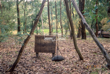
Document - Series Listing, Fraser Faithfull et al, Series 31: North Riding Living and Learning Centre, Tree Planting 1988, 23 B&W negatives, 2000
... at the North Riding Living and Learning Centre on a day devoted to tree... at the North Riding Living and Learning Centre on a day devoted to tree ...Series consists of23 B&W negatives depicting activities at the North Riding Living and Learning Centre on a day devoted to tree planting. Includes numerous indoor shots, and outdoor shots of shrub planting in the grounds.shire of eltham archives, series listing -
 Eltham District Historical Society Inc
Photograph - Colour Print, Belle Vue, Livingstone Road, Eltham, c.2015
Belle Vue property in Livingstone Road, Eltham was once owned by Society member Jo McCormick. Jo was a valued member of our committee and dear friend of many of our members until her death in 2009. Belle Vue is the farmhouse of a property that is now a significant part of suburban Eltham, just a short distance north of the town centre. Originally purchased by pioneer Eltham farmer Henry Stooke, the present-day old farmhouse sits within an extensive suburban residential area. The history of the property is largely based on a heritage assessment prepared by consultant Lorraine Huddle for Nillumbik Shire Council. Additional information from our Society records reveals Belle Vue farm comprised about 56 ha (140 acres) extending northerly from the northern boundary of Holloway’s 1851 Little Eltham subdivision. On the present day map the southern boundary was just north of Elsa Court and Grove Street. The western boundary was the Diamond Creek and extended northerly to Main Road where it turns easterly towards Research. It was traversed by the main road to Kangaroo Ground and beyond and from 1912 by the railway to Hurstbridge. From 1895 the farm was owned by William Williams and his wife Mary Ann. In 1914 -15 they built a new house now known as Belle Vue. They sold the land in 1920 and residential subdivision began soon after that. Belle Vue remains today on a substantially subdivided and very much reduced size residential lot in Livingstone Road. The house and many old trees on the site were subject to a heritage overlay under the Nillumbik Planning Scheme. Despite that overlay, the development and subdivision of the original land resulted in most of the heritage listed trees being removed. belle vue, eltham, livingstone road -
 Eltham District Historical Society Inc
Photograph, Fay Bridge, Flood damage at Nillumbik Medical Centre, 1078 Main Road, Eltham, 26 December 2011
Flood damage resulting from a late afternoon storm on Christmas Day 2011. A flash flood occurred from significant rain fall and hail, which accumulated along an old waterway with floodwater submerging cars along Valonia Drive then down Grove Street flooding houses, through the Bible Street Reserve where it then submerged Main Road washing away the small railway trestle bridge opposite the reserve then flooding the Judge Book Village before finally entering the Diamond Creek..fay bridge collection, 2011-12-26, bible street reserve, flood damage, floods, floodwater, main road, nillumbik medical centre -
 Eltham District Historical Society Inc
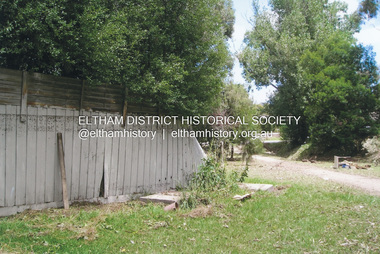
Postcard - Photograph postcard, Main Road, Greensborough, c.1910
View looking northeast along Main Street. The Greensborough Methodist Church stood at the present-day entrance to Greensborough Plaza shopping centre at 25 Main Street, Greensborough. It was opened in 1873. The Main Street Church served the congregation well, but by the 1960s it was decided to sell the old building and invest in a new home. The land at 37 Grimshaw Street for the current Uniting church was purchased in 1962 from the estate of Mrs White. Construction commenced on 31 July 1965 and the new church was opened on February 5, 1966. (https://www.churchhistories.net.au/church-catalog/greensborough-vic-uniting)Digital file only Postcards scanned from the collection of Michael Aitken on loan to EDHS, 2 Sep. 2022michael aitken collection, postcards, greensborough, main street, methodist church -
 Eltham District Historical Society Inc
Postcard - Photograph postcard, Panorama at Eltham, Vic, c.1923
The Rose Series P. 4284 post card Taken from near what would be present day CLC car park looking southwest across Diamond Street, present-day Andrew Park to the railway station and developing Eltham shopping precinct. Arthur Street visible, Pryor and Luck Street not evident. Sunnybrook, the Taylor home is visible at the top of the hill in Bible Street. Only three residences visible in Arthur Street on the southern side, two of these are the David Harbison Rest Home at 10 and 12 Arthur Street (built and opened in November 1919), present day site of Eltham Mall. There are none on the north side of the street. Based on 1945 aerial view there are 8 buildings on the northern side between Main Road and Bible Street which and given the extent of commercial development on Main Road, it is estimated this image is circa 1925. Luther Haley was the first to build an open a baker and General Store in this location next to the railway station in 1902. However, it took nearly twenty years until the early to mid-1920s when a period of significant growth in the Eltham shopping centre happened with many businesses relocating their operations from the original town centre of Maria Street in Little Eltham as well as new businesses opening. Other stores/buildings noted (L-R) are: Stationmaster's House built circa 1910 Eltham Hardware Store opposite the railway station first opened on Main Road opposite the Railway Station around late 1922. An advertisement placed in the Hurstbridge Advertiser advised that the Hardware Store had just opened with a varied stock of Saws, Hammers, Nails, Shovels, Screw Drivers, and every article required in a house or on a farm. People were also encouraged to try their Jams, Pickles, Sauces, Cups and Saucers, etc. Newsagency with 'Leader' advertising on awning - E. J. Andrew opened his newsagency shop opposite the station in March 1923, advertising for sale stationery, school requisites and periodicals. Bird Brothers Cash Grocer & Fruiterer opposite the railway station offering summer drinks and confectionery a specialty with a full Stock of groceries of the best quality always on hand at city prices opened December 1921 William Capewell's Butcher shop at the corner of Dudley Street. Capewell previously had a small shop in front of the station opposite Luck Street. He enlisted in the AIF during WW1 and returned home in 1919. He re-applied for a slaughtering license in February 1920 and was advertising by October 1922 supplying all districts. Not visible (or not yet identified) but in business by October 1922 were: J.H. Fraser, Carpenter and Builder at Luck Street opposite the station George A. Danslow, Hairdresser and Tobacconist opposite the railway station Miss Barber's 'Blue Gum' Soda Fountain opened October 1922 opposite the railway station (hidden behind Stationmaster's House). It was so named due to its proximity to a tall Blue Gum tree G.H. McDonald Boot Repairer opposite the railway station In December 1923 the first portion of the main street to be formed from Dudley to Arthur streets was almost completed. This is the section in front of Capewell's Butcher shop though it is difficult to fully make out from the photoDigital file only Postcards scanned from the collection of Michael Aitken on loan to EDHS, 2 Sep. 2022michael aitken collection, eltham, postcards, arthur street, david harbison rest home, electrine candles, eltham railway station, eltham shopping centre, lloyd's general store, red rattler, rose series postcard, rose stereograph company, tait train, velvet soap, andrew park, bible street, bird brothers cash grocer & fruiterer, bird brothers cash grocer and fruiterer, butcher, diamond street, dudley street, eltham hardware and timber, eltham hardware store, eltham mall, main road, station masters house, stationmaster's house, sunnybrook, w.j. capewell, w.j. capewell butcher shop -
 Eltham District Historical Society Inc
Photograph, Peter Pidgeon, Main Road, Eltham, 2 Aug. 2022
Comparison photo: SEPP_0610 - Main Road near Railway Station, c.1911 Shows Luther and Ada Haley’s General Store, Bakery and Tea Rooms opened September 1902 directly opposite present day Arthur Street. This was the first building in what is now Eltham’s present shopping town centre. Haley previously ran the General Store and Bakery on the corner of Main Road and York Street until his lease expired and the premises were bought by Mrs Sarah Burgoyne in 1902. Haley sold the store to Hannah Lloyd in 1917 who operated it until 1920. It then went through a succession of owners until Eric Staff purchased it in 1939. Ray Staff succeeded his father in 1954 and eventually demolished the store in 1965 opening up a new supermarket, the Eltham Big Star Food Centre. That building still stands at 929 Main Road and is the Nongkhai Thai Restaurant. On the eastern (right) side of Main Street is Haley’s Paddock, which was used on occasions for community picnics. Capable of holding 10,000 people, with ample shade and hilly surroundings it was an ideal place for any community gathering such as the State Schools’ Picnic in 1904. It was not until the early 1920s that stores started to appear between Luck and Dudley Streets. Part of a presentation by Peter Pidgeon to the Society, 13 August 2022 showcasing a series of photographs taken by John Henry Clark over the period 1895 to 1930. John Henry Clark was the youngest of three boys born to William Henry Clark (1823-1877) and Maria White (1843-1914). He and his brothers, William Charles Clark (1872-1945), Clement Kent Clark (1874-1912) operated a photography business (Clark Bros.) from 25 Thomas Street, Windsor near Prahran during the period c.1894 to 1914. Following death of Clement in September 1912 and their mother in 1914, the Clark Bros business appears to have dissolved, the premises demolished, and a new house was under construction in 1915. John set up business independently in 1914 operating out of 29 Moor Street, Fitzroy where he is registered in the 1914 and 1915 Electoral Rolls. By 1916 John had relocated to Eltham where he continued his practice as a photographer and took many of the early images around the district of Little Eltham. Around 1930 John changed professions and opened a small cobbler's shop in 1931 near the pond opposite Dalton Street adjacent to the Jarrold family cottage. He never married and continued his profession as a bootmaker from this little shop, maintaining a close relationship with Mrs Jarrold for the rest of their lives. His bootmaker shop remains today beside the Whitecloud cottage and is one of only three remaining shops in the area from the early 20th century.Comparative photo taken 2022 with one taken from same location over 100 years earlier by noted local photographer J.H. ClarkBorn Digitaleltham, j.h. clark photo (2022), main road -
 Eltham District Historical Society Inc
Album - Photograph, J.A. McDonald, Eltham-Greensborough Road, June 1956
Diamond Creek Bridge (Bridge Street Bridge) Deck being stripped June 1956 View looking southeast from the western bank of the Diamond Creek close to the present-day Eltham Skatepark. On the far centre left can be seen the Eltham Methodist Church on the cirner of John Street and Main Road, now the Eltham-Montmorency Uniting ChurchRecord of various Shire of Eltham infrastructure works undertaken during the period of 1952-1962 involving bridge and road reconstruction projects, sometimes with Eltham Shire Council Project Reference numbers quoted. It was during this period that a number of significant improvements were made to roads and new bridges constructed within the shire that remain in place as of present day (2022). In many situations, the photos provide a tangible visible record of infrastructure that existed throughout the early days of the Shire. The album was put together by or under the direction of the Shire Engineer, J.A. McDonald.infrastructure, road construction, shire of eltham, bridge construction, 1956-06, bridge street bridge, eltham, eltham-greensborough road, methodist church, presbyterian church, uniting church -
 Eltham District Historical Society Inc
Document - Property Binder, 725 Main Road, Eltham
Photocopy (A4): Map hand drawn by Peter Grier, brother to Wendy Wilson, commissioned by jeweler, Michael Wilson showing his business 'Eltham Goldsmithery' c.1979-1981. Newspaper article: Art and design venue, Diamond Valley News, August 14, 1996, p14 where it is announced that the business has been approved as an outlet for Italian design house Alessi. In same article a reference to an exhibition by the deceased 'Twenty Melbourne Painters' hanging at the Victorian Artists Society Gallery and former and present day connections with Eltham area including Angela Abbott, Peter Glass, Alan Martin, Lesley Martin, Max Meldrum, Percy Leason, Alice Bale, Walter Withers, Margery Withers, Richard Mccann. (On p13 letters to the Editor about protesting against inappropriate development and the Commissioners plans for future elected Nillumbik Council structural representation). Advertisement 19 June 2013, Michael Wilson diamond jewellers. Advertising flier 23 November 2020, Michael Wilson.main road, eltham, property, houses, shops, businesses, michael wilson jewellers, peter grier, map, eltham goldsmithery, artisans minting, cafe de chin, diamond valley railway, eltham barrel, eltham clinic, eltham collegeeltham hotel, eltham community centre, eltham gallery, eltham railway station, eltham shopping centre, eltham town park, gallery 4, john mills pottery, living and learning centre, montsalvatcountry arts store, once upon a time land, shillinglaw cottagewiregrass gallery, wingrove park, michael wilson diamond jewellers -
 Eltham District Historical Society Inc
Negative - Photograph, J.A. McDonald, Eltham, Susan Street, Jan. 1961
January 1961 Looking towards Dalton Street (present-day Withers Way) Just south of Brougham Street. To the immediate left is the present-day car park for the Elham Leisure Centre. The house on the left is immediately opposite Cromwell street and adjacent to the southwest corner of the Leisure Centre buiding (where the Williams house sits hidden from view)Record of various Shire of Eltham infrastructure works undertaken during the period of 1952-1962 involving bridge and road reconstruction projects, sometimes with Eltham Shire Council Project Reference numbers quoted. It was during this period that a number of significant improvements were made to roads and new bridges constructed within the shire that remain in place as of present day (2022). In many situations, the photos provide a tangible visible record of infrastructure that existed throughout the early days of the Shire. The album was put together by or under the direction of the Shire Engineer, J.A. McDonald.shire of eltham, infrastructure, 1961-01, cromwell street, eltham leisure centre, road construction, susan street -
 Eltham District Historical Society Inc
Negative - Photograph, J.A. McDonald, Eltham, Susan Street, Jan. 1961
January 1961 Looking south Brown excavating Brougham to Dalton (present-day Withers Way) F. Woods Consolidating showing soft fill over culvert after 9 months Just south of Brougham Street. To the immediate left is the present-day car park for the Elham Leisure Centre. The house on the left is immediately opposite Cromwell street and adjacent to the southwest corner of the Leisure Centre buiding (where the Williams house sits hidden from view)Record of various Shire of Eltham infrastructure works undertaken during the period of 1952-1962 involving bridge and road reconstruction projects, sometimes with Eltham Shire Council Project Reference numbers quoted. It was during this period that a number of significant improvements were made to roads and new bridges constructed within the shire that remain in place as of present day (2022). In many situations, the photos provide a tangible visible record of infrastructure that existed throughout the early days of the Shire. The album was put together by or under the direction of the Shire Engineer, J.A. McDonald.shire of eltham, infrastructure, 1961-01, cromwell street, eltham leisure centre, road construction, susan street -
 Eltham District Historical Society Inc
Slide - Photograph, Never Wrong Weather Station, Eltham, 23 May 1993
The 1993 Eltham Heritage Tour was enjoyed by a busload of members of the Historical Society on a fine, calm day, Sunday May 23rd. Between 10.00 am and 4.30 pm, except for a brief lunch stop at the Eltham Living and Learning Centre, members passed about thirty places of local interest and others recommended for the Historic Buildings Register and the Register of the National Estate. A number of significant trees and buildings were also highlighted along with the opportunity to explored some of the properties.35mm colour positive transparency (1 of 24) Mount - Kodak Kodachromeactivities, shire of eltham historical society, heritage excursion, eltham, houses -
 Eltham District Historical Society Inc
Photograph - Colour Print, Eltham Shire Council, Litter, Luck Street carpark, Eltham, c.1988
Luck Street Carpark near entrance to Frankllin's Supermarket, now present-day Dan Murphy's store, One of a series of 6 images taken by Eltham Shire Council officers recording litter being prevalent around the shopping precinct and carparks spreading from Luck Street through Commercial Place top Arthur Street, Elthamarthur street, car park, carparks, commercial place, eltham shopping centre, eltham shops, litter, luck street, dan murphy's, franklins supermarket -
 Eltham District Historical Society Inc
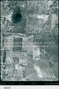
Photograph - Aerial Photograph, Landata, Eltham, Luck St; Bible St to Beard St, Dec. 1945
... Centred on present day Eltham East Primary School, east... melbourne Centred on present day Eltham East Primary School, east ...Centred on present day Eltham East Primary School, east of Main Rd along Luck St to Beard St Historic Aerial Imagery Source: Landata.vic.gov.au Aerial Photo Details: Project No :5 Project : MELBOURNE AND METROPOLITAN AREA PROJECT Run : 36 Frame : 60548 Date : 12/1945 Film Type : B/W Camera : EAG4 Flying Height : 10200 Scale : 6000 Film Number : 195 GDA2020 : 37°42'46"S, 145°09'18"E MGA2020 : 337371, 5824456 (55) Melways : 22 A4 (ed. 42)aerial photo, eltham, arthur street, beard street, bible street, eltham east primary school, frank street, henry street, luck street, stanley avenue, wycliffe crescent, neil webster collection -
 Eltham District Historical Society Inc
Photograph - Aerial Photograph, Landata, Eltham, Main Rd; Railway Rd to Zig Zag Rd, Dec. 1945
... Centred on present day Edendale Farm from Glen Park rd... melbourne Centred on present day Edendale Farm from Glen Park rd ...Centred on present day Edendale Farm from Glen Park rd to Zig Zag Rd Historic Aerial Imagery Source: Landata.vic.gov.au Aerial Photo Details: Project No :5 Project : MELBOURNE AND METROPOLITAN AREA PROJECT Run : 37 Frame : 60549 Date : 12/1945 Film Type : B/W Camera : EAG4 Flying Height : 10200 Scale : 6000 Film Number : 196 GDA2020 : 37°42'12"S, 145°09'09"E MGA2020 : 337141, 5825486 (55) Melways : 21 K2 (ed. 42)aerial photo, eltham, edendale farm, eltham - yarra glen road, eltham-hurstbridge railway line, gastons homestead, gastons road, glen park road, main road, park road, railway road, wattletree road, zig zag road, neil webster collection -
 Eltham District Historical Society Inc
Photograph - Aerial Photograph, Landata, Eltham; Crown Allotment 15, Section 5, Parish of Nillumbik (Stokes Orchard Estate), Dec. 1945
... Centred on present day Diosma Rd, Stokes Pl, Nyora Rd... melbourne Centred on present day Diosma Rd, Stokes Pl, Nyora Rd ...Centred on present day Diosma Rd, Stokes Pl, Nyora Rd and Eucalyptus Rd Historic Aerial Imagery Source: Landata.vic.gov.au Aerial Photo Details: Project No :5 Project : MELBOURNE AND METROPOLITAN AREA PROJECT Run : 36 Frame : 60546 Date : 12/1945 Film Type : B/W Camera : EAG4 Flying Height : 10200 Scale : 6000 Film Number : 195 GDA2020 : 37°42'47"S, 145°09'56"E MGA2020 : 338306, 5824438 (55) Melways : 22 C4 (ed. 42) A History of the Development of Crown Allotment 15, Section 5, Parish of Nillumbik – Stokes Orchard Crown Allotment 15, Section 5, Parish of Nillumbik (CA15) is a square allotment of 158 acres or approximately a quarter of a square mile. It lies just beyond the eastern end of Pitt Street, south of Nyora Road to the northern end of Eucalyptus Road and extends east from Eucalyptus Road to Reynolds Road. The topography of CA15 is generally steep, sloping up to a hill near the centre of the land, the ridgeline passing through the properties along the southern side of Diosma Road. Eucalyptus Road is a straight north-south road with its northern end at the north west corner of CA15. Until the end of the 1970s this road was an un-named Government Road and was largely not open to traffic. With residential development in the 1970s the road was constructed, and the council allocated the name obviously in recognition of the predominant species of the local bushland. CA15 was purchased from the Crown by George D’Arley Boursiquot, a prominent Melbourne printer, on 28th October 1852. On November 23, 1922, former Member for Gippsland and Melbourne Real Estate Agent, Hubert Patrick Keogh purchased the allotment then sold it March 13, 1925, to local farmer, Robert David Taylor, a former Shire of Eltham Councillor (1911-1920) and Shire President (1919). Taylor had extensive land holdings stretching west towards Bible Street and Main Road. The Taylor home was situated at the top of the hill in Bible Street at present day 82 Bible Street. At the time of Taylor’s purchase in 1925, CA15 was subdivided into 48 lots that could be described as small rural properties or large residential lots. A typical lot size was one hectare or 2.5 acres. The subdivision created two roads, Nyora Road, and Diosma Road, each following an irregular alignment between Eucalyptus and Reynolds Roads. However, the lots were not sold off separately nor were the roads constructed. The land effectively remained as one parcel for many further years. Robert David Taylor died November 30, 1934, and probate was granted to his son of the same name, Robert David Taylor of Bible Street, Salesman and William McLelland Vance Taylor of 73 Emmeline Street, Northcote, Clerk, with the transfer of the land into their names on July 8, 1935. Frank Stokes worked as a qualified accountant at Kennons leather factory in Burnley, while living at 1 Thomas Street, Mitcham. He suffered from migraines and wanted to return to working the land (he had previously worked on farms and orchards since coming to Australia from England in 1926, both in WA and Vic.). He first travelled to the district by train in July 1942 to find land with the intention to establish an orchard. By chance he met Arthur Bird of Bird Orchard (bounded by Pitt Street, Eucalyptus Road, and Wattle Grove) and they got talking over their common interest. Arthur put Frank up for the night and pointed out the land, 158 acres- part of the Taylor Estate- £900, Crown Allotment 15, Section 5, Parish of Nillumbik (CA15) somewhat diagonally opposite Bird Orchard. Stokes applied through the Riverina Agency to purchase the land who in turn applied for permission from Canberra to sell as there was a new government regulation introduced during the Second World War banning land sales except for immediate production. Stokes obtained a loan on his Mitcham house of £600 @ 5% and paid £450 deposit with quarterly payments of £15 spread over 5 years. Stokes was assisted and advised by Arthur Bird who farmed the neighbouring orchard. In early 1943 Stokes took possession and would catch the train out to Eltham on Fridays after work and began building a hut on the corner of Nyora Road and the Government Road (Eucalyptus Road) for shelter and to lock up tools. He established an orchard on the central western part of the land through the centre of which ran a natural waterway (part of the present-day linear park) and was able to pay a neighbour (Hawkins) to help with clearing and fencing 25 acres, and with a horse and single furrowed plough, planted approximately 2,500 fruit trees - cherries, peaches, plums, almonds, pears, apricots and lemons as well as a few apples and oranges; a massive task. Aerial photographs from the 1940s through to the 1990s clearly show the orchard with most of the larger CA15 site remaining as natural bushland. A huge problem was hares and rabbits eating all the new buds off the tiny trees. As well as laying poison he painted the trees with a mixture of cow manure and lime, often working by moonlight. Procurement of wire and wire netting was difficult because of the war but after much effort he obtained a permit from the Agricultural Department for supplies in March 1944. In February 1945 Stokes applied for a permit to build a “packing shed” as no house building was allowed. It was to be 33 feet x 21 feet and cost £312. It was constructed mostly from second-hand materials, which were hard to obtain, especially iron for roofing. Stokes finished work at Kennons on October 31, 1945, and in March 1946 he sold the family home at Mitcham for £1,230 plus £170 for furniture. On May 15, 1946, title to the CA15 property was issued to Frank Howard Alfred Stokes, Orchardist and Gladys Ethel Stokes, Married Woman, both of Pitt Street, Eltham. The family of five then moved into the very unfinished “packing shed” at Eltham, which was a struggle to weatherproof. Eventually rooms were divided off and lined with hessian bags and whitewashed. Their income was firewood (cut and sold), selling rockery stones and cut Sweet Bursaria. (It was discovered during the 1940s that Sweet Bursaria contained the sunscreen compound Aesculin. The RAAF utilised this compound from Sweet Bursaria during WW2 for pilots and gunners.) The orchard’s first fruit sale was a half-case of Le Vanq peaches in December 1947 for the price of 8 shillings. In 1956 plans for house were drawn and Glen Iris bricks purchased (1956 Olympic Rings variant). The building of the house commenced in 1957 - 12 feet of original packing shed was removed – and was completed in 1959. Water was connected from newly built pressure storage on the property at the end of 1959 and the electricity connection for the first time at 3pm on April 29, 1960. The house remains to present day (somewhat modified) at 1 Nyora Road, home to Nyora Studio Gallery. On occasions, spare remnants of the 1956 bricks have been known to be unearthed in gardens on the estate as they were utilised by Frank Stokes to fill in rabbit holes. On May 26, 1950, a parcel of land was compulsorily acquired by the Melbourne and Metropolitan Board of Works on the hilltop to establish an easement for a high-level service reservoir to augment Eltham’s water supply. The project also included pipe tracks for the necessary water mains. The reservoir has now been superseded by higher level water tanks east of Reynolds Road and its former site is now a public reserve. On November 27, 1964, the State Electricity Commission served notice to compulsorily acquire a further parcel through the eastern part of the land for a major electricity transmission line that augmented supply from the La Trobe Valley to Melbourne. The easement was registered February 11, 1966. The easement was widened July 18, 1969 for a second transmission line to be constructed. In 1971 Melbourne Metropolitan Planning Scheme amendments adopted Nyora Road as the boundary between a residential zone to the north and a rural zone to the south. This determined the future development of the land. In the mid-1970s the Shire of Eltham divided the orchard into numerous rate-able parcel lots, the 48 lots having been established in 1925 and the subsequent rates assessment proved unsustainable for Stokes. He commenced selling lots outside the boundary of the orchard, north of Diosma and South of Nyora. However shortly later the land between Nyora and Diosma Roads and west of the electricity easement was sold and subdivided into residential lots, a housing development by Macquarie Builders and marketed as the Stokes Orchard Estate. New streets were created, and most were named after trees, although one, Stokes Place, commemorates the former owners. The development was undertaken in two stages; Stage 1 (1975) encompassing Scarlet Ash Court, Ironbark Close and Peppermint Grove bounded by Nyora and Eucalyptus roads and Stage 2 (1978) encompassing Stokes Place, Orchard Way, The Crest and The Lookout bound by Nyora and Diosma roads. The developer, Macquarie Builders went bankrupt shortly after the release of Stage 2 leaving many purchasers to fend for themselves and arrange for their own independent builders. There were also difficulties with sewerage for the land immediately south of Diosma Road and so the conventional residential lots were abandoned in favour of larger lots. The development of Orchard Way, The Crest and The Lookout did not proceed as planned and the proposed lots were incorporated into five-acre parcels instead. These included a low-density group housing development by the Graves family and the award winning Choong House (1983) with Gordon Ford developed garden immediately next door situated on the ridge of the hill nestled amongst the original bush, Eucalypt trees and Sweet Bursaria. In 1994, Nillumbik Shire Council applied Significant Environment and Significant Landscape overlays upon the properties on the south side of Diosma Road to ensure protection of this natural bush garden environment. With the arrival of the sewer along Diosma Road in the 1990s, most of these five-acre parcels have since been subdivided multiple times. The Choong house presently sits on a 2.7-acre property, which in 2022 Nillumbik Council nominated for Cultural Significance Heritage protection and is considered potentially significant at State level. The Stokes family were also associated with the Eltham Christian Church. In the 1970s this church had met in temporary premises in Eltham. Lots of the original 1925 subdivision remained south of Nyora Road and a number of these lots were utilized for the Eltham Christian School, which was established by the Eltham Christian Church in 1981. The school operated on this site until 2000. The premises are now used by The Vine Baptist Church. By the mid-1980s the whole of CA15 had been developed for residential and school purposes, except for the sections north of Diosma Road and between the transmission lines and Reynolds Road. Sewerage issues had been resolved for the section north of Diosma Road and in 1987 it was in the process of being subdivided into residential lots. The development coincided with the discovery of colonies of the rare and endangered Eltham Copper Butterfly on the site. This resulted in a community and political campaign to save the butterfly habitat. With the co-operation of the land developer the subdivision was altered to create two bushland reserves in the critical butterfly habitat areas. In the late 1980s the State Government was investigating options for establishing a metropolitan ring road link between Diamond Creek and Ringwood. The chosen route was adjacent to Reynolds Road and so this created a freeze on development of CA15 between Reynolds Road and the electricity easement. The ring road proposal was eventually abandoned, and this part of the land was subdivided into low density residential lots. Diosma Road has been discontinued at the electricity easement and the eastern part incorporated into View Mount Court with access from Reynolds Road. The whole of CA15 has now been developed for residential or associated purposes, ranging from conventional density to quite low density south of Nyora Road. Some remnants of the orchard remain, a few cherry trees on the Graves property and a lone apple tree in Stokes Place. The butterfly reserves comprise significant areas of remnant bushland. Linear reserves through the estate link with central Eltham via the Woodridge linear reserve and with Research along the electricity easement. CA15 as it exists today has a complicated history of rural use, Government acquisition, urban development, and community action. References: • “Stokes Orchard, an incomplete history”; Russell Yeoman with Doug Orford • Correspondence, Beryl Bradbury (nee Stokes) • Aerial Photographs, 1931-1991, Landata (landata.vic.gov.au) • Certificate of Title, Vol. 4930 Fol. 985900 • Plan Number LP 10859 aerial photo, diosma road, eltham copper butterfly, eucalyptus road, ironbark close, nyora road, peppermint grove, peter & elizabeth pidgeon collection, power transmission lines, reynolds road, scarlet ash court, stokes orchard estate, stokes place, woodridge estate, frank stokes