Showing 1371 items
matching east side
-
 Ballarat Tramway Museum
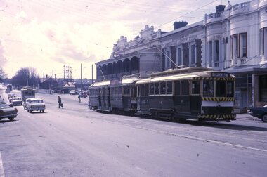
Slide - 35mm slide/s, Peter Moses, 21/08/1971 12:00:00 AM
... buildings on the east side of Lydiard St. North. Two other single... buildings on the east side of Lydiard St. North. Two other single ...Photo of SEC Ballarat No. 14 and possibly No. 42 (Briquette roof advertisement and features on the same special trams in Reg. item 2064) waiting in Lydiard St. North for the arrival of the ARHS special on Saturday 21/8/1971 to undertake the last tour of Ballarat Tramways, prior to the closure of the system. The first line closure (Victoria St.) took place the following day. Has Reid's Coffee Palace building in the background and other buildings on the east side of Lydiard St. North. Two other single truck cars in the photo as are the railway gates at the station. Kodak cardboard mount slide, taken by Peter Moses 21 August 1971.On back of slide in light black ink "N14 Ballarat / ARHS / 4 trams special Lydiard St" and "P. Moses" in black ink in the upper right hand side of the slide.tramways, trams, arhs, lydiard st north, railway crossing, tram 14, tram 42 -
 Orbost & District Historical Society
pencils, 1960's
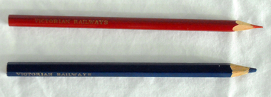
... on the east side of the river, in order to save on the costs... on the east side of the river, in order to save on the costs ...These pencils were supplied to the Orbost railway Station office to be used for clerical work. They were used by Victor Smithers who was the Assistant Station Master at Orbost from 1957 - late 1960's. He was also a reliever until the 1970's after which he returned to Ormond Station on the Frankston line where he worked until his death in 1979. The Bairnsdale-Orbost railway was opened in 1916 to serve the agricultural and timber industry. Because of the decline in traffic and heavy operating costs, the line was finally closed in August, 1987. Orbost Railway Station was opened on Monday 10 April 1916 as the terminus of the Orbost railway line, and closed in 1987. The station was located on the west side of the Snowy River despite the town of Orbost being on the east side of the river, in order to save on the costs of a bridge over the river, which at the time had highly variable levels. This item is associated with the history of the Orbost-Bairnsdale railway line and therefore reflects the role that the rail line played in the social and economic history of Orbost.Two coloured pencils. 2580.1 is a hexagonal blue pencil and has "Wolff's Emperor MADE IN AUSTRALIA". 2580.2 is a round red pencil with "Wolff's Fintorex MADE IN AUSTRALIA coloured copying". Both have "VICTORIAN RAILWAYS" marked in gold lettering on the sides. orbost-railway-station smithers-victor -
 Ballarat Tramway Museum
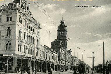
Postcard, WTP, ESCo tram west bound at the intersection of Sturt and Lydiard St. Ballarat, c1906-7
... from the east side of the intersection, looking towards... a number of pedestrians in the picture. Taken from the east side ...Printed black and white postcard of an ESCo tram west bound at the intersection of Sturt and Lydiard St. Ballarat, c1906 - 7 - has a destination box. Has a number of pedestrians in the picture. Taken from the east side of the intersection, looking towards the Town Hall, with the National Mutual Insurance building and Snows in the photo. Also shows the overhead arrangements - two wire for Sturt St, single for Lydiard St, coming into the intersection. Titled "Sturt Street, Ballarat" along the top edge. On rear of postcard are the words "Post Card", has initials "WTP" in bottom left hand corner, a 1d Victorian stamp, cancelled 1/5/07, stamp "5". Divided back type. Address to Mrs T.D. Cayett? Falcon St, North Sydney NSW. Note about their travels, where they stayed and that they had travelled to the Gardens by tram. See item 8237 for a coloured version. Black and white postcard - titled "Sturt Street Ballarat" - used 1907trams, tramways, esco, sturt st, postcards, town hall -
 Sunbury Family History and Heritage Society Inc.
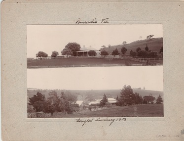
Photograph, Vineyards - Ben Eadie and Craiglee, 1903
... property was on the east side of Jacksons Creek on Macedon Road. He... property was on the east side of Jacksons Creek on Macedon Road. He ...The two homesteads are Ben Eadie and Craiglee, which were two of Sunbury's earliest vineyards that were established in Sunbury. James Stewart Johnson designed and built his concrete home, Craiglee, in 1865 where the previous year he had planted out his vineyard on the surrounding 26 acres of land.The property was on the east side of Jacksons Creek on Macedon Road. He concentrated growing Riesling and Hermitage grapes. After his death in 1896, his son Wilfred continued to produce wines until the late 1920s, when he pulled out the vines and concentrated on raising sheep for wool and meat. The Carmody family purchased the property in 1961 and in 1976 decided to replant the vineyard. Ben Eadie was built some time in 1863 and settled by the Eadie family who also were millers. The winery was built into the side of a hill close to the house but the Eadie family tended to concentrate on milling and retailing.In the earliest days of European settlement many wineries were established in the Sunbury area.Two non-digital sepia photographs have been mounted on cardboard. They are photographs of two homesteads with bare hills in the background. They were built in Sunbury in the early days off European settlementBen Eadie Vic. Craiglee Sunbury 1903john eadie, ben eadie winery, james stewart johnson, craiglee, wineries, vineyards -
 Kew Historical Society Inc
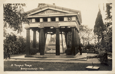
Postcard, A Temple Tomb Boroondara Vic, 1914-1920
... Photographic postcard of the east facing side... postcard of the east facing side of the Springthorpe Memorial ...A temple tomb in the form of a Greek temple with a triangular pediment. Dark pillars on a flat, paved base support the plinth of the memorial. The memorial is situated on lawn, surrounded by trees and shrubs. Between the pillars, a glass enclosure can be clearly seen. The enclosure was removed at a later date. Harold Desbrowe-Annear designed the Springthorpe Memorial, while Bertram Mackennal sculpted the statuary on the sarcophagus. William Guilfoyle is belived to have advised on the design of the garden.Photographic postcard of the east facing side of the Springthorpe Memorial in the Boroondara General (Kew) Cemetery. The photograph of the tomb record the original glass case surrounding the central group of statuary as well as a man at right contemplating the tomb. An interesting feature is the vine in the foreground covering the chain. There is also a small sundial at lower right.springthope memorial, boroondara (kew) general cemetery - victoria - australia, funerary monuments, postcards -- cemeteries -
 B-24 Liberator Memorial Restoration Australia Inc
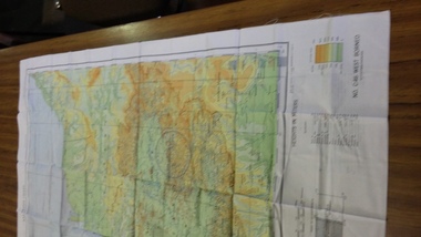
Map - Silk Escape Map, NO. C45 EAST BORNEO
... AAF CLOTH CHART NO. C-45 EAST BORNEO (Other side Chart... NO. C-45 EAST BORNEO (Other side Chart No. C-46) No.C-45 EAST ...These maps were used by Air crew in case of air craft crashing.Fabric map of East Borneo.AAF CLOTH CHART NO. C-45 EAST BORNEO (Other side Chart No. C-46) No.C-45 EAST BORNEO S120-E11340/540Nx520 -
 Bendigo Historical Society Inc.
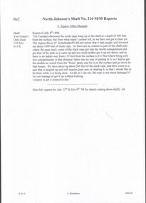
Document - MINING REPORTS - NORTH JOHNSON'S MINE MANAGERS' REPORTS
... destroying the east side of the engine-house. This was repaired... dated 29-11-1906 mentions a typhoon destroying the east side ...The North Johnson Gold Mine was situated in California Gully, Bendigo. See Trove article and plan of mine: https://trove.nla.gov.au/newspaper/article/7918876Handwritten extracts, by Albert Richardson, with typed copy of same, from the North Johnsons Mine Managers, F. Agnew, G. Roberts and J. Veale's Reports dated from 8th July 1898 to 27th Feb 1908. Report mentions cage being hung up and rope being caught and stuck, cutting down of shaft, repair of winding rope, cutting down and timbering of shaft, miner burnt when candle flared, which was believed to be caused by gas, sinking of shaft and water heavy and recommend to stop sinking shaft and start to cut a plat. (b) Report dated 29-11-1906 mentions a typhoon destroying the east side of the engine-house. This was repaired and also cleaned flues and boilers and ventilation at 3273 and 3471 feet.gold, mining reports, north johnson's mine managers' reports, f agnew, p schadendorff, the 'rose' plant, g roberts, j veale, inspector williamson -
 Kew Historical Society Inc
Functional object - Wrought iron nails from 'Reno', St John's Parade, c. 1864
... on the east side of St John’s Parade. Its earliest recorded owner.... One such property was ‘Reno’, which once stood on the east ...Comparatively few weatherboard houses in Kew survived from the early years of settlement into the second half of the 20th century. One such property was ‘Reno’, which once stood on the east side of St John’s Parade. Its earliest recorded owner was the architect Samuel Cocking who lived there from c.1865 until his death in 1888. The original landholding was bordered by Cotham Road, Glenferrie Road, Wellington Street, and Charles Street. The southern portion of this land included a fine orchard, with many imported trees. The old summer house, at first in the orchard, was later removed to the house garden. The MMBW Detail Plan No.1576 (1904) shows the remaining portion of the original land holding, including a semi-circular pathway at the front, and garden features such as an aviary, a fountain and grotto, and a fernery. None of these are apparent in photographs dating from the 1960s, where the garden, which once included rare plants provided by Baron Von Mueller, surrounds the cottage in a tangled frenzy. Despite a ‘local significance’ classification by the National Trust, the house was demolished in 1977.7 square headed iron nails collected from Reno before its demolition. In envelope marked with the name Joy Stewartreno, nails, samuel cocking -
![Wallpaper from 'Reno', St John's Parade [Kew]](/media/collectors/550653872162f11fb04854aa/items/57975996d0cdd1098c81d980/item-media/579759ded0cdd1098c81f6fa/item-fit-380x285.jpg) Kew Historical Society Inc
Kew Historical Society IncDecorative object - Wallpaper sample from 'Reno', St John's Parade, 1890s
... on the east side of St John’s Parade. Its earliest recorded owner.... One such property was ‘Reno’, which once stood on the east ...Comparatively few weatherboard houses in Kew survived from the early years of settlement into the second half of the 20th century. One such property was ‘Reno’, which once stood on the east side of St John’s Parade. Its earliest recorded owner was the architect Samuel Cocking who lived there from c.1865 until his death in 1888. The original landholding was bordered by Cotham Road, Glenferrie Road, Wellington Street, and Charles Street. The southern portion of this land included a fine orchard, with many imported trees. The old summer house, at first in the orchard, was later removed to the house garden. The MMBW Detail Plan No.1576 (1904) shows the remaining portion of the original land holding, including a semi-circular pathway at the front, and garden features such as an aviary, a fountain and grotto, and a fernery. None of these are apparent in photographs dating from the 1960s, where the garden, which once included rare plants provided by Baron Von Mueller, surrounds the cottage in a tangled frenzy. Despite a ‘local significance’ classification by the National Trust, the house was demolished in 1977. Wallpaper fragment from ‘Reno’. This small fragment of floral wall paper is a bolder design than the delicately drawn flowers in 1977.0005.1. The flowers in this example were impressionistically created using printing blocks that allowed for different thicknesses of paint to be applied in the hand-blocking process. wallpaper, reno, st john's parade, kew -
![Wallpaper from 'Reno', St John's Parade [Kew]](/media/collectors/550653872162f11fb04854aa/items/57975a62d0cdd1098c8232a8/item-media/57975cabd0cdd1098c836f91/item-fit-380x285.jpg) Kew Historical Society Inc
Kew Historical Society IncDecorative object - Wallpaper sample from 'Reno', St John's Parade, 1870s
... on the east side of St John’s Parade. Its earliest recorded owner.... One such property was ‘Reno’, which once stood on the east ...Comparatively few weatherboard houses in Kew survived from the early years of settlement into the second half of the 20th century. One such property was ‘Reno’, which once stood on the east side of St John’s Parade. Its earliest recorded owner was the architect Samuel Cocking who lived there from c.1865 until his death in 1888. The original landholding was bordered by Cotham Road, Glenferrie Road, Wellington Street, and Charles Street. The southern portion of this land included a fine orchard, with many imported trees. The old summer house, at first in the orchard, was later removed to the house garden. The MMBW Detail Plan No.1576 (1904) shows the remaining portion of the original land holding, including a semi-circular pathway at the front, and garden features such as an aviary, a fountain and grotto, and a fernery. None of these are apparent in photographs dating from the 1960s, where the garden, which once included rare plants provided by Baron Von Mueller, surrounds the cottage in a tangled frenzy. Despite a ‘local significance’ classification by the National Trust, the house was demolished in 1977.Wallpaper fragment from ‘Reno’. This large single example is interesting as it represents a change in fashion and style from the finely drawn flowers (1971.0002.1) of an older paper, parts of which can be seen behind this sample. Typically the updating of wallpapers was accomplished by laying a new paper over the old. The ‘newer’ wallpaper is of a single colour, the tone of which may have suffered from colour distortion due to ageing. The new block-printed design, featuring repeated sprays of flowers and leaves combines a bold use of colour with an elegance of design.reno, st john's parade, kew, samuel cocking, wallpaper -
![Wallpaper fragment - Reno, St John's Parade [Kew]](/media/collectors/550653872162f11fb04854aa/items/57975cd6d0cdd1098c838ddb/item-media/57975d42d0cdd1098c83c222/item-fit-380x285.jpg) Kew Historical Society Inc
Kew Historical Society IncDecorative object - Wallpaper sample from 'Reno', St John's Parade, 1870s
... on the east side of St John’s Parade. Its earliest recorded owner.... One such property was ‘Reno’, which once stood on the east ...Comparatively few weatherboard houses in Kew survived from the early years of settlement into the second half of the 20th century. One such property was ‘Reno’, which once stood on the east side of St John’s Parade. Its earliest recorded owner was the architect Samuel Cocking who lived there from c.1865 until his death in 1888. The original landholding was bordered by Cotham Road, Glenferrie Road, Wellington Street, and Charles Street. The southern portion of this land included a fine orchard, with many imported trees. The old summer house, at first in the orchard, was later removed to the house garden. The MMBW Detail Plan No.1576 (1904) shows the remaining portion of the original land holding, including a semi-circular pathway at the front, and garden features such as an aviary, a fountain and grotto, and a fernery. None of these are apparent in photographs dating from the 1960s, where the garden, which once included rare plants provided by Baron Von Mueller, surrounds the cottage in a tangled frenzy. Despite a ‘local significance’ classification by the National Trust, the house was demolished in 1977. Wallpaper fragment from ‘Reno’. These three boldly designed samples from a single room are in shades of green and brown, highlighted by yellow and red floral sprays. While more accurately printed and coloured, the fragment lacks the freedom of design of the earlier samples.wallpaper, reno, st john's parade, kew, samuel cocking -
![Reno, St John's Parade [Kew] - Reno, St John's Parade [Kew]](/media/collectors/550653872162f11fb04854aa/items/57975dcbd0cdd1098c840aaf/item-media/57975e31d0cdd1098c84343d/item-fit-380x285.jpg) Kew Historical Society Inc
Kew Historical Society IncDecorative object - Wallpaper samples from 'Reno', St John's Parade, 1880-1910
... on the east side of St John’s Parade. Its earliest recorded owner.... One such property was ‘Reno’, which once stood on the east ...Comparatively few weatherboard houses in Kew survived from the early years of settlement into the second half of the 20th century. One such property was ‘Reno’, which once stood on the east side of St John’s Parade. Its earliest recorded owner was the architect Samuel Cocking who lived there from c.1865 until his death in 1888. The original landholding was bordered by Cotham Road, Glenferrie Road, Wellington Street, and Charles Street. The southern portion of this land included a fine orchard, with many imported trees. The old summer house, at first in the orchard, was later removed to the house garden. The MMBW Detail Plan No.1576 (1904) shows the remaining portion of the original land holding, including a semi-circular pathway at the front, and garden features such as an aviary, a fountain and grotto, and a fernery. None of these are apparent in photographs dating from the 1960s, where the garden, which once included rare plants provided by Baron Von Mueller, surrounds the cottage in a tangled frenzy. Despite a ‘local significance’ classification by the National Trust, the house was demolished in 1977.Wallpaper fragment from ‘Reno’. These two large fragments of wallpaper have a formality of design that is accentuated by the wide borders and narrow vertical lines that separate the repeated designs of rose garlands in vases on a vertical trellis design. The design is in tones of pink and green with gilding.reno, st john's parade, kew, samuel cocking, wallpaper -
![Wallpaper from 'Reno', St John's Parade [Kew]](/media/collectors/550653872162f11fb04854aa/items/57975eabd0cdd1098c846619/item-media/57975ee7d0cdd1098c8484f7/item-fit-380x285.jpg) Kew Historical Society Inc
Kew Historical Society IncDecorative object - Wallpaper samples from 'Reno', St John's Parade, 1880-1914
... on the east side of St John’s Parade. Its earliest recorded owner.... One such property was ‘Reno’, which once stood on the east ...Comparatively few weatherboard houses in Kew survived from the early years of settlement into the second half of the 20th century. One such property was ‘Reno’, which once stood on the east side of St John’s Parade. Its earliest recorded owner was the architect Samuel Cocking who lived there from c.1865 until his death in 1888. The original landholding was bordered by Cotham Road, Glenferrie Road, Wellington Street, and Charles Street. The southern portion of this land included a fine orchard, with many imported trees. The old summer house, at first in the orchard, was later removed to the house garden. The MMBW Detail Plan No.1576 (1904) shows the remaining portion of the original land holding, including a semi-circular pathway at the front, and garden features such as an aviary, a fountain and grotto, and a fernery. None of these are apparent in photographs dating from the 1960s, where the garden, which once included rare plants provided by Baron Von Mueller, surrounds the cottage in a tangled frenzy. Despite a ‘local significance’ classification by the National Trust, the house was demolished in 1977. Wallpaper fragment from ‘Reno’. This small fragment is part of the larger design shown in the previous sample (1971.0002.5). It includes a detail of the trellis element from the larger scheme.wallpaper, samuel cocking, reno, st john's parade, kew -
![Letter Plate, 'Reno', St John's Parade [Kew]](/media/collectors/550653872162f11fb04854aa/items/57a03863d0cdd1210435bac1/item-media/57a038b1d0cdd1210435f155/item-fit-380x285.jpg) Kew Historical Society Inc
Kew Historical Society IncFunctional object - Letter Plate, 'Reno', St John's Parade, c.1900
... on the east side of St John’s Parade. Its earliest recorded owner.... One such property was ‘Reno’, which once stood on the east ...Comparatively few weatherboard houses in Kew survived from the early years of settlement into the second half of the 20th century. One such property was ‘Reno’, which once stood on the east side of St John’s Parade. Its earliest recorded owner was the architect Samuel Cocking who lived there from c.1865 until his death in 1888. The original landholding was bordered by Cotham Road, Glenferrie Road, Wellington Street, and Charles Street. The southern portion of this land included a fine orchard, with many imported trees. The old summer house, at first in the orchard, was later removed to the house garden. The MMBW Detail Plan No.1576 (1904) shows the remaining portion of the original land holding, including a semi-circular pathway at the front, and garden features such as an aviary, a fountain and grotto, and a fernery. None of these are apparent in photographs dating from the 1960s, where the garden, which once included rare plants provided by Baron Von Mueller, surrounds the cottage in a tangled frenzy. Despite a ‘local significance’ classification by the National Trust, the house was demolished in 1977.Brass letter plate, originally from the front door of Reno in St John's Parade, Kew. Donated by Miss McDowell in 1977, in the year the house was demolished.reno, st john's parade, kew -
![Wallpaper sample from 'Reno', St John's Parade [Kew]](/media/collectors/550653872162f11fb04854aa/items/5670dfde2162f10b54fac48a/item-media/5797600bd0cdd1098c854c29/item-fit-380x285.jpg) Kew Historical Society Inc
Kew Historical Society IncDecorative object - Wallpaper sample from 'Reno', St John's Parade, 1850-1880
... on the east side of St John’s Parade. Its earliest recorded owner.... One such property was ‘Reno’, which once stood on the east ...Comparatively few weatherboard houses in Kew survived from the early years of settlement into the second half of the 20th century. One such property was ‘Reno’, which once stood on the east side of St John’s Parade. Its earliest recorded owner was the architect Samuel Cocking who lived there from c.1865 until his death in 1888. The original landholding was bordered by Cotham Road, Glenferrie Road, Wellington Street, and Charles Street. The southern portion of this land included a fine orchard, with many imported trees. The old summer house, at first in the orchard, was later removed to the house garden. The MMBW Detail Plan No.1576 (1904) shows the remaining portion of the original land holding, including a semi-circular pathway at the front, and garden features such as an aviary, a fountain and grotto, and a fernery. None of these are apparent in photographs dating from the 1960s, where the garden, which once included rare plants provided by Baron Von Mueller, surrounds the cottage in a tangled frenzy. Despite a ‘local significance’ classification by the National Trust, the house was demolished in 1977.Original sample of nineteenth century wallpaper from one of the earliest homes in Kew (Victoria).Wallpaper fragment from ‘Reno’. These two samples of light brown Victorian-period wallpaper were overprinted with flowers and leaves that are outlined in maroon. Flowers and foliage are painted in blue of varying intensity, giving the impression of being hand painted. The style of this wallpaper would have been suited to a bedroom or drawing room.wallpaper, samuel cocking, reno, st john's parade, kew -
 Whitehorse Historical Society Inc.
Photograph - Coloured photograph, Narmara Primary School, 13/01/1994 12:00:00 AM
... from South East corner. North side of Highbury Road between... of Narmara Primary School Site, looking East from South East corner ...Coloured photo of Narmara Primary School Site, looking East from South East corner. North side of Highbury Road between Middleborough Road and Blackburn Road. Since demolished and site developed for housing.narmara primary school, warner, philip -
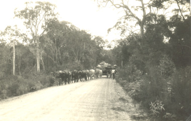 Lakes Entrance Historical Society
Photograph - Bullock Wagon, East Gippsland Victoria, 2005c
... side, East Gippsland Victoria... thick forest either side, East Gippsland Victoria East Gippsland ...Black and white photograph showing team of fourteen bullocks pulling a wagon load of produce with driver walking at side on wide and well maintained road, tall thick forest either side, East Gippsland Victoriaagriculture, transport -
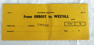 Orbost & District Historical Society
railways envelope, C 1980's
... of the Snowy River despite the town of Orbost being on the east side... of the Snowy River despite the town of Orbost being on the east side ...This item was used by Victorian Railways 1970's/1980's. It was used at Orbost Railway Station for the consignment of timber from Orbost to Westall.. Westall was a major timber-receiving depot near Dandenong, Victoria. Westall railway station is located on the Pakenham and Cranbourne lines in Victoria, Australia. It serves the south-eastern Melbourne suburb of Clayton South, opening on 6 February 1951. Westall station was opened as a workers only platform on 16 October 1954. It was provided for the adjacent Martin & King railway coachbuilding factory. The station was opened to the public on 1 June 1959 when all trains on the line began stopping there. The Bairnsdale-Orbost railway was opened in 1916 to serve the agricultural and timber industry. Because of the decline in traffic and heavy operating costs, the line was finally closed in August, 1987. Orbost Railway Station was opened on Monday 10 April 1916 as the terminus of the Orbost railway line, and closed in 1987. The station was located on the west side of the Snowy River despite the town of Orbost being on the east side of the river, in order to save on the costs of a bridge over the river, which at the time had highly variable levels. This item is associated with the history of the Orbost-Bairnsdale railway line and therefore reflects the role that the rail line played in the social and economic history of Orbost.An unused brown/buff coloured goods/freight consignment envelope used by Victorian Railways, this one for timber from Orbost to Westall. It is DL size.2497-78 VICTORIAN RAILWAYS G.F 63 From ORBOST to WESTALL MASS Tonnes kg Vehicle No Contents TIMBER Consignee Date orbost-bairnsdale-railway westall -
 Sunshine and District Historical Society Incorporated
Photograph - Three Old Sunshine Factories, Pratt, Charles Daniel, (1892 - 1968), Photographed circa late 1920's to early 1930's
... on the west side of McIntyre Road and Spalding on the east. Phoenix... on the west side of McIntyre Road and Spalding on the east. Phoenix ...These three factories clustered together and close to Albion Station provided manufacturing type of employment for several decades. All the factories have now disappeared and have been replaced by retail or service businesses. Spalding has been replaced by a Bunnings Hardware store, while the main retail outlet on the Nettlefolds site is Harvey Norman. Ironically part of the Phoenix Fireworks site is now occupied by the Metropolitan Fire Brigade, as well as other small businesses including a smash repair business, and a tyre retailer.The photograph provides a historical record of some of the types of manufacturing industries that existed in Sunshine, before retail or service industries began to replace them. Many of the younger generation do not know that fireworks, screws, or some sports items were manufactured in Sunshine not so long ago, and where the factories existed.The image depicted in this photographic copy is believed to be from circa late 1920's to early 1930's, and shows the NETTLEFOLDS, SPALDING, and the PHOENIX FIREWORKS factories. These factories were located in North Sunshine on the north side of Ballarat Road near Albion Station. Nettlefolds and Spalding are on the corner of Ballarat Road and McIntyre Road, with Nettlefolds being on the west side of McIntyre Road and Spalding on the east. Phoenix Fireworks factory is composed of small huts, and is situated on the north side of Phoenix Street at the rear of the Spalding factory. The photograph also shows a row of residential houses on Garnet Street which is on the east side of the Phoenix factory. Ballarat Road is still an undivided road and on the south side is a plantation of trees that once stretched from near Albion Station to Anderson Road. Other roads visible are Suffolk Road and Westmoreland Road.Nettlefolds Screw Worksnettlefolds, spalding, phoenix fireworks, screw works, ballarat road, mcintyre road, phoenix street, garnet street, westmoreland road, suffolk road. -
 Ballarat Tramway Museum
Photograph - Black & White Photograph/s - set of 2, The Courier Ballarat, Sep. 1971
... . Taken from the east side of Peel St. Photo used.... Taken from the east side of Peel St. Photo used ...Yields information about the nature of the street scene in Bridge St prior to closure of the system, showing the traffic, people getting off a tram and the buildings. One photo used in the Courier Supplement to mark the closure of the system.Black and White copy photographs of a newspaper photograph taken by The Courier - published 20/9/1971 in the Courier supplement of No. 32 inbound in Bridge St. Possibly taken early September 1971, prior to closure of Mt Pleasant. Both photographs very similar, tram has moved off from stop in the 2nd one. Shows Bank of New South Wales, Gallants News Agency, Walter Davis Pty Ltd, E. Glitch, ANZ Bank (ES&A) buildings. Also has signs for AVCO financial services, Tikki Salon and a Dry Cleaner. Taken from the east side of Peel St. Photo used in the Courier Supplement following the closure of the tramways. Collected by Alan Bradley from the Ballarat Courier early 1980's. See Excel file "Record of Ballarat Courier Photos SEC era" (Archive Documents) for source of details.On rear of 4772.2 stamped "Copyright, The Ballarat Courier Proprietary Limited."tramways, trams, bridge st, peel st, tram 32 -
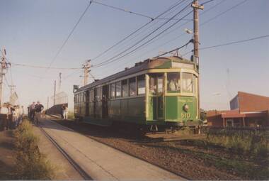 Melbourne Tram Museum
Photograph - Set of 10 Colour Print/s, Bill Davis, mid 1980's to 1990
... - .2 - 510 Thornbury - Miller St Thornbury, east side of hump... Workshops - .2 - 510 Thornbury - Miller St Thornbury, east side ...Set of 10 colour prints of tram tours in Melbourne mid 1980s to 1990. .1 - 510 on the "hump" at Preston Workshops - .2 - 510 Thornbury - Miller St Thornbury, east side of hump. .3 - 510 on the "hump" at Preston Workshops. .4 - 510 Bourke St terminus with the old MTOCo / MMTB building in the background. .5 - ditto .6 - L104 entering Malvern depot from Glenferrie Rd. .7 - 380 north bound in Glenferrie Rd near Riversdale Rd. .8 - 646 and 720 both on special trams at Thornbury Depot. .9 - 646 and three other trams at Malvern depot - see also Reg Item 931 - 1018 in Benetton clothing advertisement March 1990. .10 - 646 at Brunswick depot. Item .1 to .8 printed on Kodak paper, .9 and .10 printed on Fujichrome paper.trams, tramways, mmtb, tours, malvern depot, brunswick depot, preston workshops, bourke st, glenferrie rd, tram 510, tram 380, tram 104, tram 646, tram 720, tram 1018 -
 Melbourne Tram Museum
Photograph - Set of 11 Colour Print/s, Bill Davis, mid 1980's to 1990
... terminus. .11 - 913, inbound Glenhuntly Road, on the east side..., inbound Glenhuntly Road, on the east side of Glenhuntly Station ...Set of 11 colour prints of Melbourne trams and locations during the mid 1980's to 1990, Photos not well focused. .1 - trams 782, 259 and 2002 out the front of South Melbourne Depot .2 - 979 and 888 at ditto .3 - 888 .4 - 975 and two other W's at Preston Depot .5 - 2001 - Burwood Road on a Special, near Hawthorn Bridge. .6 - ditto .7 - 968, Kingsway, South Melbourne near Sturt St .8 - 861 ditto .9 - 881 outbound St Kilda Road .10 - 900 and W2 442 (Restaurant tram 1) at Acland St terminus. .11 - 913, inbound Glenhuntly Road, on the east side of Glenhuntly Station. Features advertisements on trams for: Triple FM Radio, Bank of Melbourne, Space Deamons Printed on Kodak, Fujichrome or Konica paper.trams, tramways, ptc, south melbourne depot, preston depot, burwood rd, kingsway, st kilda rd, acland st, glenhuntly rd, tram 782, tram 259, tram 2002, tram 2001, tram 979, tram 888, tram 975, tram 968, tram 861, tram 881, tram 900, tram 442, tram 913 -
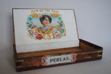 Anglesea and District Historical Society
Cigar Box, Perlas?, Estimated date: mid 20th century
... Top: GEM OF THE EAST / MANILA / FILLER Side: PERLAS...: GEM OF THE EAST / MANILA / FILLER Side: PERLAS (on label). 25 ...Wooden cigar box probably from the mid 20th century. The inside of the top of the box has a picture of an Eastern woman with coins and flowers. Perlas - is a small cigar taking 30 minutes to smoke. This cigar contains Manila filler.Top: GEM OF THE EAST / MANILA / FILLER Side: PERLAS (on label). 25 (burned on wood). Label along edges of top, sides and bottom - "PUROS FABRICA DE TOBACCO - FLORFINA"smoking, cigars, perlas, gem of the east -
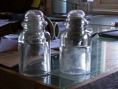
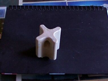 Parks Victoria - Gabo Island Lightstation
Insulator
... away. The first telegraph office was a timber building on east... away. The first telegraph office was a timber building on east ...Modern communication technologyarrived on gabo Island with the construction of the telegraph line from Eden to Gabo Island in 1870. The insulator is associated with the telegraph station. Used at the H.F Radio Beacon. The items of telegraphic equipment comprise a number of ceramic and glass insulators of varying age and type. In addition to insulators, there is a telephone insulator bracket made of metal with wooden pins. It was once attached to the top of a steel pole and some of these remain in situ along the former telegraph line (0044). Telegraphic communication commenced at the Gabo Lightstation in 1870, just eight years after the lightstation opened. The line from Sydney reached Eden, NSW by 1868 and was then extended to Gabo with the costs shared equally by NSW and Victoria. It was initially carried on posts across the sea to the island but was changed to a line along the seabed after the posts were washed away. The first telegraph office was a timber building on east side of the assistants’ quarters. In 1887 a new concrete telegraph office was built which included quarters for the operator, with Victoria and NSW sharing the construction costs. The 1992 CMP identified remnants of the line from its various phases of operation,and these were seen in 2016. Other ceramic insulators in the collection are associated with lines supported on utility poles for the transmission of high voltage electricity. The various insulators have second level significance for their historic value and provenanceFour armed cross shaped insulator with two holes through diagonally opposite sections. It is ceramic with a clear glaze. -
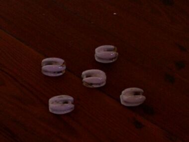 Parks Victoria - Gabo Island Lightstation
Insulators
... . The first telegraph office was a timber building on east side.... The first telegraph office was a timber building on east side ...Modern communications technology arrived on Gabo Island with the construction of the telegraph line from Eden to Gabo Island in 1870. This type of insulator was usually used with radio antennae wires, telegraph and radio antennae equipment. The items of telegraphic equipment comprise a number of ceramic and glass insulators of varying age and type. Five, knuckle-shaped white glazed ceramic examples are associated with radio antennae wires. In addition to insulators, there is a telephone insulator bracket made of metal with wooden pins. It was once attached to the top of a steel pole and some of these remain in situ along the former telegraph line. Telegraphic communication commenced at the Gabo Lightstation in 1870, just eight years after the lightstation opened. The line from Sydney reached Eden, NSW by 1868 and was then extended to Gabo with the costs shared equally by NSW and Victoria. It was initially carried on posts across the sea to the island but was changed to a line along the seabed after the posts were washed away. The first telegraph office was a timber building on east side of the assistants’ quarters. In 1887 a new concrete telegraph office was built which included quarters for the operator, with Victoria and NSW sharing the construction costs. The 1992 CMP identified remnants of the line from its various phases of operation, and these can still be seen in 2016. Other ceramic insulators in the collection are associated with lines supported on utility poles for the transmission of high voltage electricity. .The various insulators have second level significance for their historic value and provenanceFive white glazed ceramic insulators. Knuckle bone sized, oval shaped with one opening at either end. All five are the same. -
 Parks Victoria - Gabo Island Lightstation
Insulators
... away. The first telegraph office was a timber building on east... away. The first telegraph office was a timber building on east ...Modern communication tecnology arrived on Gabo Island with the construction of the telegraph line from Eden to Gabo Island in 1870. These and other cylindricial insulators were associated with the original 1870 copper wire telegraph line and later the P.M.G. line. The items of telegraphic equipment comprise a number of ceramic and glass insulators of varying age and type. Two bell-shaped insulators are made of clear glass, one with remains of wooden dowel inside. In addition to insulators, there is a telephone insulator bracket made of metal with wooden pins. It was once attached to the top of a steel pole and some of theseremain in situ along the former telegraph line. Telegraphic communication commenced at the Gabo Lightstation in 1870, just eight years after the lightstation opened.The line from Sydney reached Eden, NSW by 1868 and was then extended to Gabo with the costs shared equally by NSW and Victoria. It was initially carried on posts across the sea to the island but was changed to a line along the seabed after the posts were washed away. The first telegraph office was a timber building on east side of the assistants’ quarters. In 1887 a new concrete telegraph office was built which included quarters for the operator, with Victoria and NSW sharing the construction costs. The 1992 CMP identified remnants of the line from its various phases of operation,231 and these can still be seen in 2016. Other ceramic insulators in the collection are associated with lines supported on utility poles for the transmission of high voltage electricity. The various insulators have second level significance for their historic value and provenance1. Clear glass insulator. Cyndrical bottle shape with smaller dome -like knob on top. Hollow with inscription on lower edge. Has remains of wooden dowell inside. 2.Clear glass insulator. Cyndrical bottle shape with smaller dome -like knob on top. Hollow with inscription on lower edge.Around lower edge on opposite sides,"C.C / 42" -
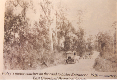 Lakes Entrance Historical Society
Photograph, Foleys motor coaches on the road to Lakes Entrance, 1920 c
... of road, telephone poles on right side. East Gippsland Victoria..., telephone poles on right side. East Gippsland Victoria Foleys motor ...Sepia toned photograph showing Foleys motor coaches on road to Lakes Entrance possibly near Bennetts Brook, coach and trailer in front A Ford and trailer behind, tall trees on either side of road, telephone poles on right side. East Gippsland VictoriaFoleys motor coaches on the road to Lakes Entrance c 1920 Courtesy East Gippsland Historical Societytransport -
 Port Melbourne Historical & Preservation Society
Photograph - East balcony, interior Port Melbourne Town Hall, c. 1980
... Hall: east balcony from opposite side (B&W)..., of the 1938 version of the Town Hall: east balcony from opposite side ...One of a group of eight laminated copies from photos held in Port Phillip's City Collection, of the 1938 version of the Town Hall: east balcony from opposite side (B&W)Laminator (or lasercopier) has left marks lower centreport melbourne town hall, town planning, heritage -
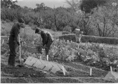 University of Melbourne, Burnley Campus Archives
Album - Black and white prints, Collection of Photographs, Unknown
... of paths "Camp," on reverse. (3) East side of Administration... of paths "Camp," on reverse. (3) East side of Administration ...15 black and white photographs. Collection is all the same size but 2 different kinds of borders. Provenance unknown. (1) 3 male students cultivating the vegetable plots. (2) View of paths "Camp," on reverse. (3) East side of Administration Building. "The Building," on reverse. (4) Students in the Library. (5) Female student driving a tractor in the Orchard. (6) Canna. (7) Lilies and ? in a vase. (8) Cacti collection in front of Glass Houses (moved to present site in 1975 as a student exercise.) (9) Cacti collection in front of Glass Houses. "Film Projector," on reverse. (10) Students standing beside signs in front of Lily Ponds on Open Day. (11) People looking at display for Open Day in Hall. (12) Display in Hall on Open Day. "Table Tennis," on reverse. (13) Open Day display in Hall. " (14) Open Day display in Hall. (15) Students standing beside Grafting display for Open Day in Orchard. students, vegetable plots, library, female students, tractor, orchard, flowers, cacti, lily ponds, open day, administration building, glasshouses -
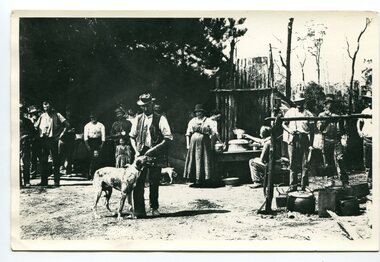 Orbost & District Historical Society
black and white photograph, C1914
... of the Snowy River despite the town of Orbost being on the east side... of the Snowy River despite the town of Orbost being on the east side ...This is a photograph of a railway camp, set up to house workers and their families when building the Bairnsdale to Orbost Railway from 1914-1916. The man in the foreground was one of three men killed in an explosion "noon on the railway construction works at Hagen's Cutting, about two miles from Orbost, three men being killed. The victims were John Carroll, con- tractor, his son, Peter Carroll, and John Sullivan, a navvy. The gang had just finished work, and the three stayed behind to draw a blasting charge, which had missed fire yesterday. J. Carroll was using a pick, and it is presumed that the tool struck a percussion cap, and fired the charge. He and Sullivan were killed instantly, Carroll being literally blown to pieces. Fragments of his body and garments were recovered from the surrounding bush, and the main portion of the trunk, with leg attached, was hurled a distance of 200 yards. Peter Carroll was terribly- injured, and he died before medical aid arrived." (from The Mercury Saturday March 114 1914) The Bairnsdale-Orbost railway was opened in 1916 to serve the agricultural and timber industry. Because of the decline in traffic and heavy operating costs, the line was finally closed in August, 1987. Orbost Railway Station was opened on Monday 10 April 1916 as the terminus of the Orbost railway line, and closed in 1987. The station was located on the west side of the Snowy River despite the town of Orbost being on the east side of the river, in order to save on the costs of a bridge over the river, which at the time had highly variable levels. This item is associated with the history of the Orbost-Bairnsdale railway line and therefore reflects the role that the rail line played in the social and economic history of Orbost.A black / white photograph of a campsite. There is a kitchen outside a rough construction. Men and women are standing in the backgroundd with one man and a dog in the foreground.on back - "Man with dog killed in explosion"orbost-railway transport railway-bairnsdale-orbost explosion-railway