Showing 391 items
matching elevation
-
![Plan, University of Melbourne Burnley Campus Institute of Land and Food Resources Formerly known as the Royal Horticultural Gardens Burnley [sic], 2001](/media/collectors/52f2d90c9821f4163875a333/items/6145823c174069677c22f6e6/item-media/65ef8feeb2201fddf6999498/item-fit-380x285.jpg) University of Melbourne, Burnley Campus Archives
University of Melbourne, Burnley Campus ArchivesPlan, University of Melbourne Burnley Campus Institute of Land and Food Resources Formerly known as the Royal Horticultural Gardens Burnley [sic], 2001
site plan, buildings, planrs -
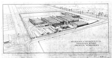 Melbourne Tram Museum
Drawing, Melbourne & Metropolitan Tramways Board (MMTB), "Melbourne & Metropolitan Tramways Board Preston Workshops", late 1920's?
Dyeline print of a perspective elevation of the MMTB Preston Workshops, titled "Melbourne & Metropolitan Tramways Board Preston Workshops", drawing No. W531. Shows the layout of the buildings, tracks, traversers, Thornbury Workshops, railway line and junction arrangements. In the bottom right hand corner is a draftsman's name "K. V. McGuiness". Scanned in a hi res format March 2016trams, tramways, mmtb, preston workshops, thornbury depot, drawings -
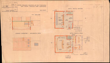 Melbourne Tram Museum
Drawing, Melbourne & Metropolitan Tramways Board (MMTB), "Carlton - Proposed new control room and remodelling of existing control room", May. 1961
Drawing - titled - "Carlton - Proposed new control room and remodelling of existing control room", coloured with a water colour brush, showing the proposed extensions to the Carlton control room, drawing Number S842, dated 9-5-1961. Shows the ground and first floors, mess room, offices, stairs and control room layout. Has the external elevations and sections.Has some pencil notations front and back re lights and sketch.trams, tramways, carlton, control centre, power supply, electrical engineering, electrical switching -
 Federation University Historical Collection
Document, Anne Beggs Sunter, Green Hill History, c2001
The Green Hill settlement dates from the 1860s. Developers in the 1960s chose to call it Mt Helen rather than Green Hill. Mt Helen is believed to be named after Helen Hastie, the daughter of Reverend Hastie of Buninyong. In 1866 a 241 acre site was purchased for a new tertiary institution. It is now known as the Federation University Mount Helen Campus. Green Hill is a scoria dome and though dominated by Mt Buninyong (Elevation 2442 feet) it is thought to have been formed earlier. Three pages History of Greenhill by Anne Beggs Sunter, and two further pages of notes.greenhill, green hill, mount helen, mt helen, mt helen campus, federation university, elizabeth downing, george dean, latta, davis, skelton, watkins, john latta, elizabeth latta, william watkins, pontresina, rabits, dr longden, abraham baxter, noel robson, jane robson, george inglis, mt helen railway station, ballarat technology park, g. dean, green hill wesley church, jim downing, bob thornton, stapleton, hately, martin fanning, toll keeper, ralph fiscalini -
 Vision Australia
Plan - Image, Proposed additional nurses bedroom to "Myer Home" existing nursery, Blind Institute, St Kilda Rd, 23/8/1949
In 1949 an architect produced this plan to detail the addition of a bedroom for the nursing staff, who looked after children in the Blind Babies nursery. The plan shows a layout of the RVIB site, including the 'Myers Home' (the name of the nursery) where young children were cared for. The south and eastern elevations are detailed, as well as a plan of the nursery, which had 4 bedrooms, a living room, a dinning room , bathroom, 2 kitchen areas and the proposed additional nurses bedroom next to Bedroom 4.1 architectural plan of Myer House and proposed extensionPercy E Everett, Chief Architectroyal victorian institute for the blind, rvib nursery, plans, myer house -
Clunes Museum
Drawing, HARRY SANDO
ARCHITECT DRAWING OF CLUNES PRESERVING BOILER HOUSE .1 DATED 12 MARCH 1897 .2 DRAWING "BUILDING OF THE BOILER", LONGITUDAL ELEVATION APRIL 1987 .3 DRAWING NO. 1 DATED 12 MARCH 1897 .4 DRAWING OF MAIN BUILDING TESTING ROOM .5 DRAWING OF CAST IRON RING AND WROUGHT IRON COVER TO BOILER 21/4/1897.5 THESE ARE THE DRAWINGS REFERRED TO IN TENDER DATED 9 DAY OF APRIL 1897 FOR BUILDING BOILER AND OTHER WORK AT THE LOTHAIR BOILER HOUSE, DATED AT CLUNES THIS 29 DAY OF APRIL 1897 SIGNED BY THE CONTRACTOR, WITNESS TO SIGNATURE HARRY SANDO clunes preserving company, boiler house, lothair boiler house -
Whitehorse Historical Society Inc.
Document - Documents, Schwerkolt Cottage Management and Opening, c1965 - 1966
Collection of documents relating to the management and opening of Schwerkolt Cottage in October 1965, comprising: Letters from the Town Clerk, City of Nunawading to Mrs J. Field, Hon Secretary Schwerkolt Cottage Committee of Management, regarding formation of a Committee of Management with draft and final resolutions; plans and elevations by John and Phyllis Murphy, restoration architects; and notes on progress of restoration prior to opening.schwerkolt cottage, city of nunawading, murphy, john, field, jean -
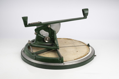 Department of Energy, Environment and Climate Action
Fire Finder
Victoria once had well over one hundred fire lookouts and firetowers. Fire lookouts, or observation posts, were often just a clearing on a hill or a vantage point, whereas firetowers were definite structures. Many were established by the Forests Commission Victoria (FCV) in the 1920s, but the network was expanded rapidly in response to recommendations of the Stretton Royal Commission after the 1939 Black Friday bushfires. When a fire or smoke was spotted from the tower a bearing was taken with the alidade and radioed or telephoned into the district office. It was then cross referenced with bearings from other towers on a large wall map to give a "fix" on the fire location. Alidades and telescopes were used in the post war period but were replaced with a much simpler map table and reference string suspended from the centre of the tower cabin. This "Fire Finder" was used in Canadian fire towers to identify the location of wildfires. The unique design was first developed by the British Columbia Forest Service (BCFS) in the early 1950s. Close examination of the map indicates that this particular Fire Finder may have been once used at Bluejoint Mountain lookout in Granby Provincial Park. This Fire Finder was a gift to Barry (Rocky) Marsden from the British Columbia Forest Service in the late 1980s in recognition of the close relationships that had been forged with the staff at the Altona Workshops over many decades. Fire Finders were originally painted black but this one was repainted green after it arrived at Altona. The BC Forest Service had a large facility where they manufactured Fire Finders and many other items of equipment, but in the 1980s it was shut down. Heavy cast iron circular object with a paper topographic map mounted on it. The metal dial and ruler works similar to a compass. The sight tube is used to determine the bearing and elevation of the fire on the map. This Fire Finder also sometimes known as an Alidade. Its a different design from the Osborne Fire Finder widely used in North American fire lookouts from the 1920s. British Columbia Forest Service. Model 62A. Serial Number 6308.bushfire -
 Melbourne Tram Museum
Pamphlet, Yarra Trams, "Power supply upgrade project - J. S. Grey Reserve West Preston", Jul. 2016
Digital image of a folded A4 pamphlet titled "Power supply upgrade project - J. S. Grey Reserve West Preston", about the construction of a new sub-station on the reserve, gives construction dates, impact, site plan, elevation plan, reason or need for the sub-station for tram power upgrades. Dated July 2016. A4 print made for files.trams, tramways, substation, power supply, yarra trams, west preston -
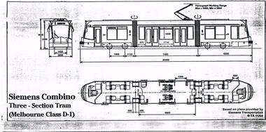 Melbourne Tram Museum
Drawing, Transit Australia Publishing, "Siemens Combino Three Section Tram (Melbourne Class D1)", "Siemens Combino Three Section Tram (Melbourne Class D2)", Nov. 2002
Set of two drawings of the Melbourne Siemens Combino Trams, class D1 and D2, produced by Transit Australia, November 2002, based on plans from Siemens Transportation. Side and end elevations and floor plans with leading dimensions. .1 - "Siemens Combino Three Section Tram (Melbourne Class D1)" .2 - "Siemens Combino Five Section Tram (Melbourne Class D2"trams, tramways, drawings, tramcars, d class, tramcar design -
 Bendigo Historical Society Inc.
Plan - MARKS COLLECTION: PLAN EXTRA BOILER LANSELL'S 180 MINE
Engineering drawings for the (written on bottom of plan) 'No 2-arrangement extra boiler for Lansells Proprietary little 180 Mine Bendigo Plan shows chimney - side elevation, measurements of chimney, flue, boiler (and existing boiler, existing loco boiler) On bottom of plan: Scale 1/4 inch = 1 foot. Hargreaves & Daggar, Consulting Engineers, Victoria Chambers, Bendigo.mining, equipment, lansell's little 180 mine -
 Bendigo Historical Society Inc.
Document - MARKS COLLECTION: PLAN LANSELL'S COMET PROPRIETARY MINE BENDIGO
Plan (engineering drawings) for construction of crushing and elevating plant at Lansell's Comet Proprietary Mine, Bendigo. Drawings show detail for crusher and elevator, brick foundations. Plan is annotated with e.g. number of revolutions of jaw crusher. On bottom written in black pen: arrangement crushing and elevation plant for Lansell's Proprietary Comet Mine Bendigo, Hargreaves & Daggar, Consulting Engineers, Victoria Chambers.mining, crushing & milling, lansell's comet mine -
 Bendigo Historical Society Inc.
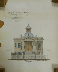
Plan - MARKS COLLECTION: DRAWING OF ENTRANCE HALL FORTUNA VILLA
Laminated drawing of entrance hall to Fortuna Villa. Drawing is hand coloured and depicts stone building, entrance steps leading to double glass doors with side lights beside and above doors. Turret on top of building. On bottom of drawing is written 'Elevation' on top of plan Proposed Entrance Hall Fortuna Villa for G. Lansell Esq. Signed by W. Beebe, Architect.bendigo, buildings, fortuna villa -
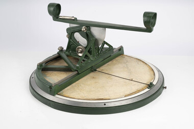
 Department of Energy, Environment and Climate Action
Balloon Theodolite 1943
Used to measure the rate of rise of helium balloons The telescope is mounted on two movable axes. One axis (vertical) rotates to change elevation, the other (horizontal) azimuth. There are vernier scales and in some cases micrometres that give precise readouts of the relative position of the telescope to each axis. The instrument is set up so that it is level and it is pointed towards true north with both scales reading 0 degrees exactly. A balloon is released in front of the theodolite. It is sighted at timed intervals (usually one minute apart) and the position of the theodolite's telescope (azimuth and elevation) is recorded. It can chart the direction and velocity of winds at various altitudes The rate of ascent of a balloon is mostly dependant on the balloon's drag and its "free lift" (the vertical pull of the balloon). There is some degree of control over these these factors, and as a result, it possible to know approximately how high our balloon will be at any given time after its release. Given a known height and an angular direction (read off the theodolite) to the balloon, a fix is made of the horizontal movement component of the balloon's travel as it moves through different altitudes. The horizontal movement is due to the winds blowing the balloon around at the altitudes that the balloon is traveling throughTheodolite used to measure the rate of rising helium balloons The rate of rise is used in atmospheric calculations such as upper winds and determining inversion layersforests commission victoria (fcv), bushfire, weather -
 Bendigo Historical Society Inc.
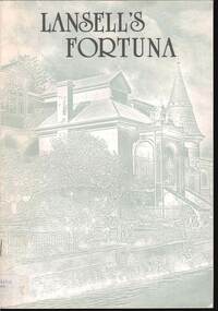
Document - FORTUNA COLLECTION: LANSELL'S FORTUNA
Lansell's Fortuna Brochure -Stapled brochure -sketch of main entrance to Lansell's Fortuna Villa on the front cover /rear page shows 'Conceptual elevation for the development of Fortuna Villa by architect W.O. Beebe / the first page shows "Commanding Officer's Introduction 'with mention of George Lansell's most likely approval of the Army's acquisition of his property /the brochure contains black and white and coloured photosdocument -
 St James Old Cathedral
Cathedral Building, St James Old Cathedral, 09/11/1839
St James Church, "Church of the Pioneers", was the first Church, first Anglican Church, and is the oldest building in Melbourne. The foundation stone was laid in 1839 by the Superintendent of the District of Bourke, Charles La Trobe, later Governor of the Colony of Victoria. The Church was opened in 1842 and the first Bishop Charles Perry was installed in the Cathedral in 1848 when its status changed to that of Cathedral. Its status changed back to that of a Parish church after 1891 when St Paul's Cathedral in Swanston Street was opened. St James is known as the "Church of the Pioneers" as it served as the place of worship, marriage, baptism and burial of many of the first families in the District of Bourke and the Colony of Victoria. St James Old Cathedral is of the most important historic value to the community of Victoria and to the Australian nation as the first Anglican Church founded within 4 years of the settlement of Melbourne. It represents and conserves the very earliest history of white settlement in Victoria and preserves the church associated history of the Pioneer families of Victoria in its collection of original records and artefacts. Late Neo-Georgian style stone church building with bluestone footings. Octagonal upper one storey bell tower housing eight bells supported by two storey square towers. Body of church has sloping roof and 4 stained glass ornamental windows on each of west and east sides with decorative sanctuary window to the north. Decorative Portico with columns on the north outside elevation. National Trust Commemorative plate on outside wall to right of east entry door. -
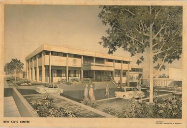 Kew Historical Society Inc
Drawing, AK Lines, Macfarlane & Marshall, Kew Civic Centre, c.1970
The Kew Civic Centre (A K Lines, MacFarlane & Marshall, 1972) was built next to the Kew Civic Hall (A C Leith & Bartlett, 1960) on the site of the former mansion Ordsall (later renamed South Esk). Whereas the entrance to the Civic Hall was positioned off Civic Drive, the main entrance to the Civic Centre faced Cotham Road, as shown in the undated perspective drawing of the proposed building. The Civic Hall was used for public functions and performances, while the Civic Centre was used for civic offices. It also contained the Council Chamber. The building opened in 1972, following the relocation of the councillors and council officers from the former Town Hall in Walpole Street (now a Woolworth's supermarket). Following the amalgamation of the former City of Kew into the City of Boroondara in 1994, the Civic Centre was sold to Trinity Grammar School. The exterior of the Centre has been modified by Trinity Grammar.A report for Heritage Victoria (date) describes how two architectural firms dominated the designs for new civic buildings in Victoria during the post war period. The report claims that: "An interesting sub-theme in the erection of post-war municipal offices in Victoria is that a considerable proportion were designed by the same three or four Melbourne-based architectural firms, who established themselves as the leading specialists in this type of work. The two most prolific firms in this regard were A K Lines, MacFarlane & Marshall, and A C Leith & Bartlett; both, in fact, had made names for themselves as designers of local government offices prior to the Second World War. Lines' office, for example had designed the Eltham Shire Offices in 1941, while Leith's firm had been responsible for the celebrated Heidelberg Town Hall in 1937). Both practices parleyed this early experience into a lucrative post-war career, designing numerous municipals offices well into the 1970s." (Survey of Post-War Built Heritage in Victoria, Built Heritage Pty Ltd, 2010.) The perspective drawing importantly captures the original design and function of the exterior of the building and its public entrance.Hand-coloured perspective sketch of the new Kew Civic Centre, completed in 1972 to designs by A K Lines, MacFarlane & Marshall; and located on the corner of Charles Street and Cotham Road, Kew. The sketch represents the front elevation of the building and its relation to the preexisting Kew Civic Hall at right. The three storey building features strong vertical concrete buttresses that extend across the three levels. KEW CIVIC CENTRE / A K LINES, MACFARLANE & MARSHALLkew civic centre, a.k. lines, macfarlane & marshall, architectural drawings, civic buildings -- kew (vic.), town hall -- kew (vic) -
University of Melbourne, Burnley Campus Archives
Plan, Methodist Ladies College, 1986 -1988
(1) Site Plan showing Carparking by Hayball Sanderson & Partners Job No 86/142. Drawing No A1. Scale 1:55. November 1986. (2) Master Plan Courtyard Design by Richard Nosworthy, 8.11.88 Sheet No 2 (of 2) Elevation. (3) Master Plan MLC by Michael Doensen 8.11.88. Scale 1:100 Sheet No 1 of 2 Courtyard Planting Plan.Names: Cath Coates, Darren Wilson added in inkrichard nosworthy, michael doensen, methodists ladies college, kew -
Linton and District Historical Society Inc
Floor plan, Floor plan - Linton State School No. 880
A3 size photocopy showing floor plan and east side elevation of Linton State School building. The plan appears to show where new flooring will be required. The number W144563 is written in the top right hand corner. The plan is not clearly dated, however the initials "R. P." followed by the numbers "10/57" suggests that this plan may have been drawn up in 1957.linton state school no. 880, maps and plans, floor plan -
 Bendigo Historical Society Inc.
Document - MARKS COLLECTION: PLAN PRINCIPAL ENTRANCE FORTUNA VILLA AND GARDEN FRONT
2 copies of plans. 1. Smaller plan; written on plan Principal Entrance Front Fortuna Villa Sandhurst, G. Lansell Esq, Proprietor. Plan shows front entrance elevation, also floor plan of vestibule and verandah. 2. Large plan: written on plan Garden front, Fortuna Villa Sandhurst, G. Lansell, Esq. Proprietor dated July 3rd. 1871. buildings, house, fortuna villa -
Stawell Historical Society Inc
Map - Drawings, Wendy Jacobs, Western Highway, 2014
WD 1/13 - Site Plan WD 2/13 - Existing Conditions & Demolition Plan WD 3/13 - Floor Plan WD 4/13 - Elevations WD 5/13 - Sections AA & BB WD 6/13 - Sections CC WD 7/13 - Sections DD, EE & FF WD 9/13 - Roof Plan WD 10 /13 Reflected Ceiling Plan WD 12/13 - Toilet & Meeting Cup'd Details WD 13/13 - DetailsEleven (11) A1 Printed MapsWendy Jacobs Architect & Heritage Consultant Nov 2014 -
 Federation University Historical Collection
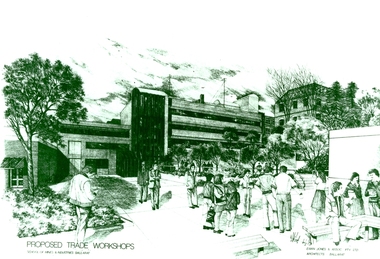
Photograph - Photograph - Black and White, Proposed Ballarat School of Mines Trade Workshops, c1984
A design for a Trade and Art Workshop at the Ballarat School of Mines was prepared by Ewan Jones and Associates on the Albert Street boundary around 1984. The M.B. John Building (Building K), a three storey, face red brick, restrained Late Twentieth Century International styled building with an elongated, cuboid form (defined by the parapeted facades) that is offset by projecting exposed concrete framed, round‐arched entrance and stair wells on the east (Albert Street) elevation (the centrally located entrance breaking the brick façade with glazing). The facades are also characterised by banks of aluminium framed, horizontal ribbon windows, which wrap around the building corners. Metal shades project beyond the windows, while post‐supported bullnosed verandahs and hoods and projecting concrete stairs are other features. On the west elevation, the cuboid façade is punctuated by projecting curved concrete and glazed, elongated bays at first floor level. (David Rowe/Wendy Jacobs) The M.B. John Trade–Art building of SMB was officially opened by the Hon. John Cain, Premier of Victoria, in the presence of Morgan B. John. Programs include 3 Dimensional Art, Painting & Decorating, and Engineering Trades. (SMB Institutional Plan 1989)Black and white photograph of a sketch for the proposed Trade Workshops at the Ballarat School of Mines, from the Albert Street vantage point. This building is known as the M.B. John Building on the SMB Campus.ballarat school of mines, trade workshops, flecknoe, m.b. john, ewan jones and associates pty ltd, albert street, morgan b. john, ewan jones and associates -
 Flagstaff Hill Maritime Museum and Village
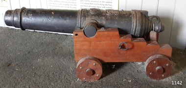
Weapon - Carronade
This deck cannon is believed to be a replica Carronade as it has no foundry mark, year of manufacture, proof marks or weight of carronade on it. However, its design matches the design of Carronades used in the early to mid 19th century. History: The carronade was designed as a short-range naval weapon with a low muzzle velocity for merchant ships, but it also found a niche role on warships. It was produced by the Carron iron works and was at first sold as a complete system with the gun, mounting, and shot altogether. Carronades initially became popular on British merchant ships during the American Revolutionary War. A lightweight gun that needed only a small gun crew and was devastating at short range was well suited to defending merchant ships against French and American privateers. Its invention is variously attributed to Lieutenant General Robert Melville in 1759, or to Charles Gascoigne, manager of the Carron Company from 1769 to 1779. In its early years, the weapon was sometimes called a "mellvinade" or a "gasconade". The carronade can be seen as the culmination of a development of naval guns reducing the barrel length and thereby the gunpowder charge. The Carron Company was already selling a "new light-constructed" gun, two-thirds of the weight of the standard naval gun and charged with one-sixth of the weight of the ball in powder before it introduced the carronade, which further halved the gunpowder charge. The theory of its design was to use less powder and had other advantages that were advertised in the company's sales pamphlet of the time, state. The smaller gunpowder charge reduced the barrel heating in action, also reduced the recoil. The mounting, attached to the side of the ship on a pivot, took the recoil on a slider, without altering the alignment of the gun. The pamphlet advocated the use of woolen cartridges, which eliminated the need for wadding and worming, although they were more expensive. Carronades also simplified gunnery for comparatively untrained merchant seamen in both aiming and reloading that was part of the rationale for adopting the gun. Other advantages promoted by the company were. The replacement of trunnions by a bolt underneath, to connect the gun to the mounting, reduced the width of the carriage that enhanced the wide angle of fire. A merchant ship would almost always be running away from an enemy, so a wide-angle of fire was much more important than on a warship. A carronade weighed a quarter as much as a standard cannon and used a quarter to a third of the gunpowder charge. This reduced charge allowed Carronades to have a shorter length and much lighter weight than long guns. Increasing the size of the bore and ball reduces the required length of the barrel. The force acting on the ball is proportional to the square of the diameter, while the mass of the ball rises by the cube, so acceleration is slower; thus, the barrel can be shorter and therefore lighter. Long guns were also much heavier than Carronades because they were over-specified to be capable of being double-shotted,(to load cannons with twice the shot, for increased damage at the expense of range). Whereas it was dangerous to do this in a carronade. A ship could carry more carronades, or carronades of a larger caliber, than long guns, and carronades could be mounted on the upper decks, where heavy long guns could cause the ship to be top-heavy and unstable. Carronades also required a smaller gun crew, which was very important for merchant ships, and they were faster to reload. Additional notes: Cannon cast in England, Wales and Scotland had their imperial weight chiselled or engraved in the format of 4-2-0 on the bottom of the cascabel, indicating the weight of the cannon as 4 hundredweight, 2 quarters and 0 pounds. Since a hundredweight equals 112 pounds and a quarter weight is 28 pounds the total weight is 504 pounds or about 228 kilograms. The small bore replica carronade and carriage is part of a collection of nineteenth Century Flagstaff Hill Guns and cannons, and is a representation of carronades used from the early 18th up to the 1850s on merchant and military ships particularly the British Royal Navy until 1850. This example is not significant in the historic sense but demonstrates the type of artillery used aboard vessels of the time for protection & offensive military actions. Cannon, cast iron, small smooth bore cannon on the stepped wooden carriage with wooden wheels. It appears to fire a 12-pound cannonball. The Cannon barrel can have its elevation adjusted via a sliding sloped block at the rear of the cannon. Gun carriage has loops for locating and holding the carriage in position with the use of ropes. It is believed this carronade is a replica of a mid-to-late 19th-century Carronade cannon.Cast into metal; [Royal emblem of Queen Victoria (VR "Victoria Regina")]warrnambool, flagstaff-hill, flagstaff-hill-maritime-museum, maritime-museum, shipwreck-coast, flagstaff-hill-maritime-village, cannon, naval cannon, cannon on carriage, 19th century cannon, fortifications, smooth bore cannon, 12 pounder, carronade, artillery, replica, deck cannon, cannon in carriage, ship cannon -
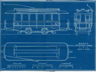 Ballarat Tramway Museum
Plan, Ken McCarthy, "NSWGT - Electric trams 1,2,3 1890 - 1900", May. 1960
Yields information about the nature of the trams that came from Sydney to Ballarat for the first electric tramcars and has a strong association with the person who prepared by the plan.Blueprint plan of NSW Govt. Tramway cars 1,2,3,- Roof plan, front and side elevation - with side running trolley poles - 3/8"=1' scale with O gauge 1/4 and O gauge 3/8" scale marked. (These cars become part of the 1905 ESCo Ballarat Fleet). Imaged by scanning in two halves and joining together - could do some further work.trams, tramways, nswgt, plans, tramcars, esco -
 Bendigo Military Museum
Plan - MONUMENT PLANS, 9.7.1992
All three pertain to the erection of a Monument in front of the Soldiers Memorial Institute in Pall Mall Bendigo to honour Ex Servicemen and Women. Refer Cat No 8245.2.1) Plan, white paper, black print on black graph paper showing front elevation and plan of a monument, signed, dated and stamped. .2) Plan, white paper black print showing plan and section A.A of same structure as .1). .3) Plan, white paper black print showing position of proposed monument as in .1) in front of a building with gardens surrounding. signed, dated and stamped.On all three written and stamped, " Planning and Environment Act 1987 Bendigo Planning scheme - Plan refrred to in Permit No 096/92 - Application No 096 (signature) 9.7.92 - for and on behalf of the responsible authority"brsl, smirsl, plans, monument -
 Melbourne Tram Museum
Document - Specification, Yarra Trams, Tramcars, c2005
Set of 8 A4 colour printed sheets giving the tram details and specifications and side elevation sketch for the W, Z1/2, Z3, A, B1/2,C, D1 and D2 class trams. Not printing date, but c2005. Features photos of trams1031, 30, 212, 284, 2010, 3026, 3513 and 5004. Document imaged as a pdf, though the first sheet miscoloured - see image i2.jpgtrams, tramways, yarra trams, tramcars, z class, a class, b class, c class, d class, tram 1031, tram 30, tram 212, tram 284, tram 2010, tram 3026, tram 3513, tram 5004 -
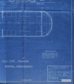 Melbourne Tram Museum
Drawing, Melbourne & Metropolitan Tramways Board (MMTB), "PCC Type Tramcar - General Arrangement", 19/07/1950 12:00:00 AM
Drawing, blueprint, titled "PCC Type Tramcar - General Arrangement", MMTB drawing No. R8313, dated stamped 19 Jul 1950 in the bottom right hand corner, drawing dated 19-4-50. showing an outline of the PCC type tramcar, elevations and floor plan. Has details of seating capacity. For the full drawing see the Mechanical drawings files, for R8313. Has a note that it superseded drawing R7828.trams, tramways, pcc, drawings, mmtb, tram 980 -
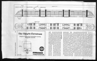 Melbourne Tram Museum
Poster, Keith Kings, Transit Australia, "The Oporto Eurotram", Apr. 2003
Poster - of a page of the April 2003 issue of Transit Australia, giving an elevation and floor plan of "The Oporto Eurotram" that was demonstrated in Melbourne during January and March 2003. Has an outline dimension drawing of the tram and the Bombardier builder and logo, with some details about it operations and limitations about curves. Has been prepared using two sheets of A3 paper. See Reg Item 4754 for photos by Colin Rough.trams, tramways, combino, citadis, eurotram, melbourne, docklands, aeta, tram 18 -
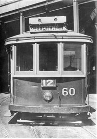 Ballarat Tramway Museum
Photograph - Black & White Photograph/s, c1920
Black and white photograph of MMTB No. H60 at Kew depot. Tram painted in MMTB chocolate and cream colour scheme. Front elevation photo with depot buildings in background. Has old style destination box on roof, showing "DEEPDENE". Tram of same class at SEC No. 18 See also Registration No. 550 ( for side view of tram) Original photo by Suttcliffe Studios of Cromwell buildings 366a Bourke St. Melbourne"trams, tramways, melbourne, kew depot, h class , tram 60