Showing 4488 items matching "for sale"
-
 Bacchus Marsh & District Historical Society
Map, Pentland Hills Estate Land Sale 1904
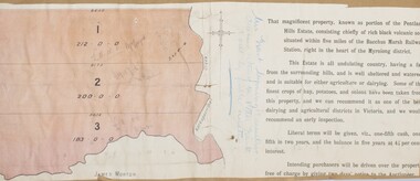
The Pentland Hills Estate property shown in this auction plan was put up for sale in 1904. It was a deceased estate sale. The property had been owned by Peter Grant who died in 1899. Peter Grant had worked and farmed in the Myrniong area for many years and had also been a Councillor on the Bacchus Marsh Shire for a number of terms. A property sales report in the Express newspaper recorded that the land for sale comprised 500 acres of the old Pentland Hills Estate. It was subdivided into three lots, all of which were sold at good prices. Lot l, 212 acres was sold to Messrs Thomas and Robert Lidgett of Myrniong, at £11/15/ per acre, lot 2, 200 acres, to Mr David Robertson, of Bacchus Marsh, at £9 17/0 per acre, and lot 3, 38 acres, was sold to Mr James Norton, jun at £11 per acre. A single page paper map showing a portions of land available for sale from the Pentland Hills Estate near Bacchus Marsh.The name of the seller, Mrs Grant, can seen handwritten on this map and the buyers of the three portions for sale, Lidgett lot 1, Robertson lot 2 and Morton lot 3. Parts of the text are missing along the edges due to tearing or excessive trimming of the edges. The map is pasted into a bound volume containing 76 maps or plans in total. High resolution digital image stored on BMDHS computer network. Handwritten: Mrs Grant, Myrniong, Executrix in the deceased Estate of Mr. Peter Grant to sell by public auction.land sales, pentland hills maps, myrniong area land sales, pentland hills estate -
 Bacchus Marsh & District Historical Society
Map, Bullengarook Estate Property Sale. 1911
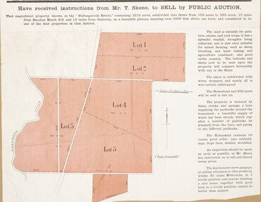
Bullengarook is a locality located 19 kilometers north of Bacchus Marsh. Pastoral leases for European colonists were granted to people for this area from around the 1840s.The Bullengarook Estate was part of these early pastoral holdings. By the 1900s the property had been owned by the Skene family for a number of years. In early 1911 the property then consisting of 300 acres and the homestead upon it was offered for sale in one lot. It appears however that the sale of the property did not go through in 1911. It was later leased by Thomas Skene to a Mr Coutts in 1915 and ultimately and at a later stage the property was sold by the Skene family.A single page paper map showing land allotments for sale from the Bullengarook Estate. The map is pasted into a bound volume containing 76 maps or plans in total. High resolution digital image stored on BMDHS computer network. land sales bacchus marsh, bullengarook land sales, bullengarook estate, bullengarook vic history -
 Ringwood and District Historical Society
Flyer, Flyer advertising auction sale of ex service station site in Ringwood, Victoria - 1974
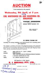
Single page advertisement for auction sale of restricted business site, corner of Whitehorse Road and Wantirna Road, Ringwood, Victoria, on Wednesday, 9th April (1974).Advertisement includes location map and terms of sale of 3 separate certificates of title on land zoned as Restricted Business (Not to be used for any petroleum product business). Sole Agents - K.J. Mulhall Pty. Ltd., 358 Lonsdale Street, Melbourne (Telephone) 67 8338, A.H. 91 1511. Auctioneer - Allan Lord. Handwritten notation describes this as originally the site of Ibbotson's Hay and Corn Store. -
 University of Melbourne, Burnley Campus Archives
Document, Memo, 1983
Books for salebooks, library -
 Orbost & District Historical Society
Book, The Cunninghame Progressive Association, Guide to Buchan Caves & the Gippsland Lakes, c.1900-1910
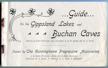
This booklet was issued as a tourist advertising/promotion for the Gippsland Lakes and Buchan Caves. It was most likely printed in the early 20th Century. This promotion also includes associated areas such as Lake Tyers, Cunninghame (Lakes Entrance), Nowa Nowa, Sale, and Bairnsdale. An early tourist promotion for East Gippsland, focussing on Melbourne tourists travelling to Sale or Bairnsdale by train, and then by steamer or coach. An example of an early tourism promotion.A booklet of 103 pages, printed in b/w. The cover is a dk. red paper with gold print, quite fragile. The book contains b/w photographs, advertisements, time tables for trains and steamers travelling through the Gippsland Lakes from Sale to Cunninghame (eg. SS JCD), also a map of the steamer route. ...Guide... To the Gippsland Lakes and Buchan Caves (Written by Frank Whitcombe, and Illustrated by H D Bulmer and N J Caire). Issued by The Cunninghame Progressive Association. J R Coate (President), Alfred Nation (Hon. Secretary), Committee - W S Barke, P Harbeck, E J Wyld, T Roadknightbuchan caves, gippsland lakes, ss j c d, tourism -
Lakes Entrance Historical Society
Book, Morrissey, D.W and Morrissey E.W, Lakes Entrance a Short History revised Edition, 1980
History of Koorie inhabitants through to fishing industry, timber industry, early settlers and survey and sale of land. The opening of the entrance to allow shipping industry to operate bringing much trade and movement of primary produce etc. Local schoolHistory of Koorie inhabitants through to fishing industry, timber industry, early settlers and survey and sale of land. The opening of the entrance to allow shipping industry to operate bringing much trade and movement of primary produce etc. Local schoolMargaret Campbell''land settlement, religion, aboriginals -
 Bacchus Marsh & District Historical Society
Map, Plan of Land at Bacchus Marsh, the Property of James Young, 1868
James Young was a prominent businessman, land owner and public figure in the early colonial period of Bacchus Marsh. In February 1868 he offered for sale through the agent W. Anderson 38 blocks of land which ran from the Lerderderg RIver westwards beyond Gisborne Road in the vicinity of the present day Masons Land. The land for sale was described as, 'unsurpassed Agricultural Land, in the immediate vicinity of Bacchus Marsh, varying in size from 2 to 12 acres each'. The sale notice in the Bacchus Marsh Express of 1st February 1868 page 2, also noted that, ' Plans can be seen at Mr. Young's Border Mills Store, and at the Border Inn'. One of the largest and most important land sales in the early colonial period of Bacchus Marsh.A single page paper map showing 38 blocks of land for sale in 1868 in the vicinity of Masons Lane Bacchus Marsh. Scale 11 chains to 1 inch. The map is pasted into a bound volume containing 76 maps or plans in total. High resolution digital image stored on BMDHS computer network. land sales bacchus marsh, bacchus marsh victoria maps, james young 1816-1871, masons lane bacchus marsh land sales -
 Ringwood and District Historical Society
Flyer, Subdivisional Land Auction Sale Brochure, Grand Central Estate, Ringwood, Vic. - 1925
Douglas Street shown in the estate plan did not eventuate, but was developed as a public reserve. Refer also to Reg. No. 5149 for 1924 auction sale of land also titled Grand View Estate situated further north in Ringwood.Double sided multi-folded page advertising public auction sale on Saturday, 31st October, 1925, of residential allotments highlighting local facilities, services and layout of the estate. Includes panoramic view of Ringwood and other local photographic images.Subdivision includes Great Ryrie Street, Heathmont Road, Douglas Street, Garden Street, and Bellevue Avenue. Agents - Knight & Harwood, 315 Collins Street, Melbourne, Phone 10615, 10616 Central, in conjunction with J.B. McAlpin, Opposite Railway Station, Ringwood. Phone Ringwood 7. -
 Bacchus Marsh & District Historical Society
Map, Bacchus Marsh Suburban Allotments Parwan Road Lodge & Dunn's Paddocks 1888
This map was created as a plan for an auction of land close to the Bacchus Marsh Railway Station. The auction took place on 23 October 1888. 102 allotments of land from an area known as Lodge and Dunn's paddocks was offered for sale. A single page paper map showing allotments of land for sale along the Parwan Road in Maddingley. The map is pasted into a bound volume containing 76 maps or plans in total. High resolution digital image stored on BMDHS computer network. land sales bacchus marsh, land sales maddingley, bacchus marsh victoria maps, maddingley victoria maps -
 City of Moorabbin Historical Society (Operating the Box Cottage Museum)
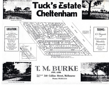
Flyer - Tuck's Estate, Cheltenham, 1940
After WWII there was a decline in the market gardens in the City of Moorabbin, as the value of the land was more profitable than the crops.Example of the progress of the Municipality of MoorabbinPhotocopy of advertising flyer for sale of real estate sales - plan of building blocks for saleTuck's Estate Cheltenham - plan of subdivisionedward street, point nepean road, eden street, tuck street, hoffman street, elman road, page street, cheltenham, real estates, auction, tuck -
![Map, Plan of Town Allotments Bacchus Marsh [1873]](/media/collectors/5e461d8021ea67224c82f2a1/items/677a8ee7ab7bb47995c5573f/item-media/677a8fdeab7bb47995c55b56/item-fit-380x285.jpg) Bacchus Marsh & District Historical Society
Bacchus Marsh & District Historical SocietyMap, Plan of Town Allotments Bacchus Marsh [1873]
James Young was a prominent businessman, land owner and public figure in the early colonial period of Bacchus Marsh. After his death in 1871 land remaining from his estate in Bacchus Marsh was sold at auction in 1873. The sale of his estate included the substantial stone residence in Bennett Street which later became known as 'Stone Villa'. The sale of his land in 1873 was conducted by local auctioneer James Crook. 29 allotments were advertised for sale, although the plan for the sale indicated 30 allotments. The sale notice in the Bacchus Marsh Express of 11 October 1873 noted that the allotments were " in the very centre and heart of the most populous and business portion of the township, at the same time being the only remaining portion of the business block available for purchase by public sale, which fact intending purchasers should not lose sight of, as the opportunity cannot occur again". The designation of a new street, 'Bennett Street', shown on the plan, is also indicated in the advertising, "In reference to the main street frontages, opposite the Border Flour Mills. The Auctioneer would also direct attention to the plan, showing the formation of a new thorough fare (Bennett street) leading from Young street into Gell street, thus opening up the township on the high, more healthy, and commanding position so much to be desired for private dwellings".An important cartographic document which indicates an early major subdivision of land in the inner urban area of the Bacchus Marsh township. This subdivision lead to the continuing residential and commercial development of the township of Bacchus Marsh in the later part of the 19th century. The location of two well known demolished public structures, the Free Gardeners Hall in Gell Street, and the Old Mechanics Institute Hall (aka the Buffs Hall), on the corner of Young and Bennett Streets, are also shown on this map.A single page paper map showing 30 blocks of land for sale around 1873 in the vicinity of Bennett Street and Lerderderg Street. Described in contemorary sources as a 'lithographed copy'. No scale is indicated. The map is pasted into a bound volume containing 76 maps or plans in total. High resolution digital image stored on BMDHS computer network. land sales bacchus marsh, bacchus marsh victoria maps, james young 1816-1871, bacchus marsh roads and streets, bennett street bacchus marsh -
Whitehorse Historical Society Inc.
Map, The Parish of Nunawading, 1853
Photocopy of manuscript plan with allotments numbered and some named.Photocopy of manuscript plan with allotments numbered and some named. Note on verso: The Parish of Nunawading in the County of Bourke; lithographed at the Surveyor General's office by J.Jones Jan 18th 1853. Endorsed Sale Plan 271. Dray tracks, water holes and terrain indicated.Photocopy of manuscript plan with allotments numbered and some named. land subdivision, maps, parish of nunawading, jones, j -
 Bacchus Marsh & District Historical Society
Map, Plan of the second portion of the property of Messers Atkins and Clarke situate at Bacchus Marsh 1856
This plan of land allotments for sale indicates part of the property once owned by the Bacchus family in and around the township area of Bacchus Marsh. The Bacchus family sold their property in Bacchus Marsh to John Aitkins and Robert Nalder Clarke in March 1851. Aitkins and Clarke kept the property for a number of years until April 1856 when these allotments were put up for sale.This is a very early land sales plan for agricultural land close to the township of Bacchus Marsh. It therefore provides some clues as to how the early urban development of the township and agricultural development of the nearby area took place. Upon seeing the map in 1911 Bacchus Marsh Express newspaper editor Christopher Crisp wrote "The sale appears to have created the present township, which had a nucleus in earlier times further east", Express, 30 September, 1911, page 3.A single page paper plan showing allotments of land for sale. The subdivided land shown was owned by John Aitkins and Robert Nalder Clarke, but previously owned by the Bacchus Family and was in and around their Manor House (Mansion) property in Bacchus Marsh. This plan shows allotments in the second portion of land to be sold which was located east of the Manor House on the eastern side of the Lerderderg River. The land for sale was made up of 15 allotments. The plan is pasted into a bound volume containing 76 maps or plans in total. BMDHS Loc: AR/B12/S4 Bacchus Marsh Township and Nearby Districts Maps Volume In-house Digital copies: BMDHS, Computer Network: Maps\Bacchus Marsh Township and Nearby Districts Maps Volumebacchus marsh victoria maps, bacchus family, land sales, manor house bacchus marsh -
 Robin Boyd Foundation
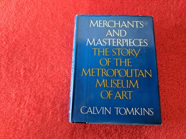
Book, Calvin Tomkins, Merchants and Masterpieces: The Story of the Metropolitan Museum of Art, 1970
Hardcover w/ Dust JacketLorna Ruddick Book Sale trade 1975walsh st library -
 Ambulance Victoria Museum
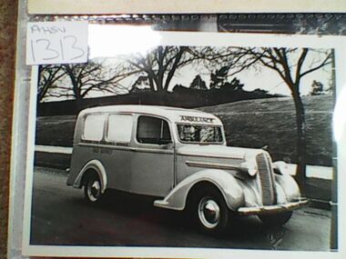
Photograph, ambulance, 1938 Dodge
Black and white photograph. Ambulance with trees in background.Victorian Civil Ambulance Service Sale Districtvictorian civil ambulance service -
 Lakes Entrance Historical Society
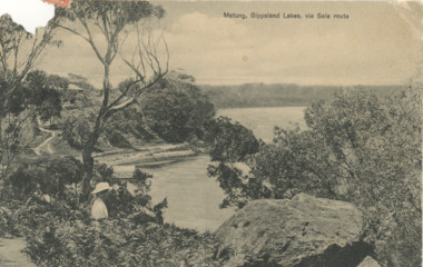
Postcard, printed in Germany, Bancroft Bay Metung, 5/09/2012 12:00:00 AM
Black and white postcard showing road into Metung around Bancroft Bay showing house on hill in background possibly John McMillans Burilda, lady with hat in foreground viewing scene, boat shed below, Metung VictoriaMetung Gippsland Lakes via Sale routepeople, houses, waterways -
 Lakes Entrance Historical Society
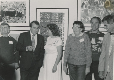
Photograph - Woodsedge Art Centre Colour Gang Art Show, Lakes Post Newspaper, 4/04/1991 12:00:00 AM
Woodsedge Art Centre Colour Gang Art Show Frank Powell Richard Peach ABC radio Sale Grace Jobling Pres Newayung Debbie Heystratten Stephen Smith Lawrence Licctone Lakes Entrance VictoriaBlack and white photograph at Woodsedge Art Centre Colour Gang Art Show Frank Powell Richard Peach ABC radio Sale Grace Jobling Pres Newayung Debbie Heystratten Stephen Smith Lawrence Licctone Lakes Entrance Victoriaarts, exhibition -
 Melbourne Legacy
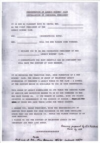
Document, Inauguration of Legacy Widows' Club. Installation of President, 1984
A suggested speech to be used when a President of Melbourne Legacy attends the inauguration of a widows' club. It includes the installation of the Widows' Club first president. It was written in 1984 and used at the opening of at least three widows' clubs, in Sale, Beaumaris and Camberwell. Was in a binder of documents that is passed from an outgoing President to the incoming President. It is primarily from the 1930s to 1990s. Most documents are being catalogued separately.A record of part of a ceremony used to start a new Widows' Club.Yellow A4 paper x 1 page with black type of a speech to open a Widows' Club used in 1984.Handwritten note on bottom 'Ceremony proposed by L/Trebilcock. Used by JCD. First used at Sale, March 84; then Beaumaris 25/6/84; Camberwell 28/10/84.'widows, widows clubs -
 Warrnambool and District Historical Society Inc.
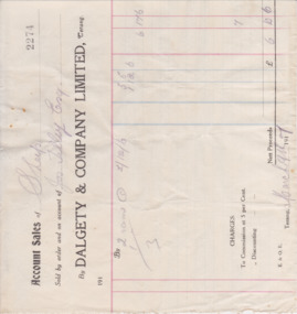
Document - Docket: Dalgety & Co Jos Tilley 1917, 1917
This docket, from the firm of Dalgety and Company Limited of Terang, gives details of the sale of three rams on behalf of Joseph Tilley of ‘Aringa’. The total profit for Mr Tilley was £6-10-6. Joseph Tilley ran the property of ‘Aringa’ which was on the Portland Road, five miles from Port Fairy. He also owned the Penshurst Hotel at the same time. Dalgety and Company was established by Frederick Dalgety in Melbourne in 1846, primarily to support sheep farmers. In 1993 Dalgety Farmers became a subsidiary of the A.N.Z. Bank and the pastoral interests of the company were taken over by Wesfarmers.This docket is of some importance as it is an original one and gives details of a 1917 sale of a bull, with the names Wilson and Anderson and Tilley of some local interest. It gives us the prices for bulls at the time and the type of account form used.This is an original docket of 1917. It is a printed one with printed red and blue lines for entering the details of the client. The client’s name and sale details are handwritten in pencil.wilson and anderson, joseph tilley, aringa -
Southern Sherbrooke Historical Society Inc.
Map - photocopy
A photocopy taken from the original land sale map provided to the society through Karel Coxell of Stockdale & Leggo. The original maps are stored in large bound account books and were originally the propert of McNally Real Estate. The books are held (in 2A3 photocopy of plan of survey of part of Crown Allotments 20 & 21, section C, parish of Narre Worran, County of Mornington. Clements Ave and environs in Belgrave Heights"Villette Estate" in top LH corner, "Locality Plan" in bottom LH corner, "Not in sale" written on one block and crossed out. All handwritten in pencil on original. "Colby Drive " and "Verona Street" added in pencil to copy.land sales, advertisements, subdivision -
 Federation University Historical Collection
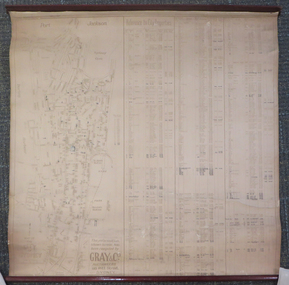
Document - Chart, Port Jackson, Reference to City Properties, 1930s
This chart was compiled using information compiled by Gray & Co Auctioneers of 135 Pitt Street, Sydney and contains information relating to the streets of Port Jackson with the property numbers and dates of sale until 1930, the dimensions of the properties and the purchase prices. It was most likely part of the School of Mines Ballarat collection.This dirty cream chart is of the streets of Port Jackson with the property numbers and dates of sale until 1930, the dimensions of the properties and the purchase prices. Some property numbers have been added by hand. It has timber ends, top and bottom.Some information has been added by handport jackson, reference to city properties, chart, gray & co auctioneers, sydney, kenneth craigie sydney, property information -
 Whitehorse Historical Society Inc.
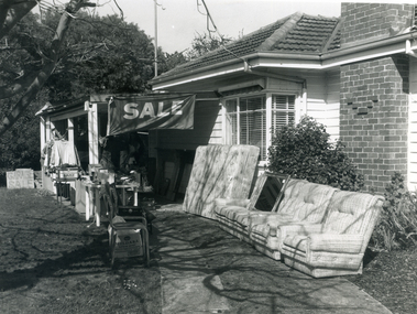
Photograph, Garage Sale, 1994
Black and white photograph of a garage sale in Forest Hill. Sale sign, mattress and lounge suite in foregroundgarage sales -
 Lakes Entrance Historical Society
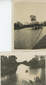
Photograph - Swing Bridge Sale Victoria
Also another black and white photograph of Thompson River 05222.1 9 x 6 cmBlack and white photograph of Sale Swing bridge which is open on Thompson River south of Sale Victoriawaterways, bridges -
 8th/13th Victorian Mounted Rifles Regimental Collection
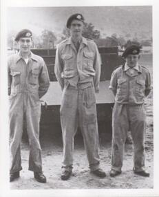
Photograph
The 8th/13th Victorian Mounted Rifles was raised as a regiment of the Royal Australian Armoured Corps on 1 May 1948 with Headquarters in Melbourne and squadrons in Sale, Benalla/Wangaratta and Albury. In 1955 Regimental Headquarters moved to Wangaratta and a second squadron was located at Albury. The Sale squadron transferred to 4th/19th Prince of Wales’s Light Horse. In 1977 8/13 VMR Regiment was reduced to an independent squadron A Squadron 8th/13th Victorian Mounted Rifles and in 1991 was linked with 4th/19th Prince of Wales’s Light Horse forming the VMR Squadron of that regiment.Unique collection of photographs showing the first years of an armoured regiment of the post-Second World War era Citizen Military Forces showing equipment, uniforms, training and social activity and some personalities.Black and white photograph of three soldiers standing in front of Doodlebug Scout Car, dressed in " tank" overalls and berets. The 8th/13th Victorian Mounted Rifles was raised as a regiment of the Royal Australian Armoured Corps on 1 May 1948 with Headquarters in Melbourne and squadrons in Sale, Benalla/Wangaratta and Albury. In 1955 Regimental Headquarters moved to Wangaratta and a second squadron was located at Albury. The Sale squadron transferred to 4th/19th Prince of Wales’s Light Horse. In 1977 8/13 VMR Regiment was reduced to an independent squadron A Squadron 8th/13th Victorian Mounted Rifles and in 1991 was linked with 4th/19th Prince of Wales’s Light Horse forming the VMR Squadron of that regiment." George Atkinson, Regt./Cadet, John Bullock. -
 Ringwood and District Historical Society
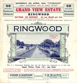
Flyer, Subdivisional Land Auction Sale Brochure, Grand Central Estate, Ringwood, Vic. - 1924
Refer also to Reg. No. 5148 for 1925 auction sale of land also titled Grand View Estate situated further south in Ringwood.Double sided multi-folded page advertising public auction sale on Saturday, 5th April, 1924, of residential allotments highlighting local facilities, services and layout of the estate. Includes panoramic view over the estate and other local photographic images. Additional clipped copy of subdivison map on blue cardboard backing includes real estate sales notations.Subdivision includes Whitehorse Road, Rupert Street, Herbert Street. and Leonard Street. Agents - Knight & Harwood, 315 Collins Street, Melbourne, Phone 10615, 10616 Central, in conjunction with J.B. McAlpin, Opposite Railway Station, Ringwood. Phone Ringwood 7. -
 National Wool Museum
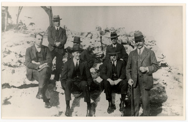
Photograph - Group Portrait, Hobart
Part of a collection of four photographs depicting wool sales, wool classers and auction rooms. This group portrait was taken in Hobart and depicts men who were working in the wool industry at the time, including wool classer James Campbell Bell. James Campbell Bell emigrated from England to Sydney then Melbourne, in the early 20th century.Black and white photograph depicting seven men seated and standing near a cliff at the seaside. All the men are wearing suits and ties, one has a pipe in his mouth, one holds a walking stick.Back: [Handwritten] ? Whit? / ? / Hobart Wool Sale / Hobartwool auction, wool sales, wool industry, hobart, james campbell bell, seaside -
 Melbourne Tram Museum
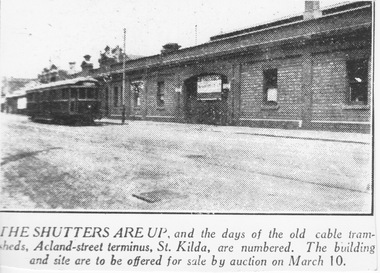
Photograph - Acland St Car Shed for auction, c1926
Photograph is of a newspaper cutting of photograph and caption. It shows a W or W2 class tram in Acland St, St Kilda passing the single level brick frontage of the disused cable car shed. The closed main entry doors carry a large sign about its future sale. Apart from the closure of a short section of track in northern Swanston St in 1924, the St Kilda Beach to Windsor and to the city line was the first full cable line to be closed in 1925. It reopened as an electric line in December 1925.Yields information about the closure of the St Kilda Esplanade cable line. Black and white print copy of newspaper photograph with caption belowTyped "The Shutters are up, and the days of the old cable tram-shed, Acland-street terminus, St Kilda, are numbered. The building and site are to be offered for sale by auction on March 10." -
 Running Rabbits Military Museum operated by the Upwey Belgrave RSL Sub Branch
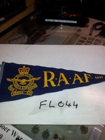
Pennant
Pennant RAAF East Saleflag/banner, raaf -
 Melton City Libraries
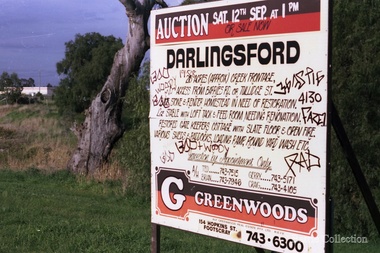
Photograph, Darlingsford sign, Unknown
The barn is now used as a community function space.Signage for the sale of Darlingsford propertylocal identities, local architecture, council -
 Ringwood and District Historical Society
Flyer, Land Sale Advertisement - Roebury Estate, Ringwood, Victoria - circa 1938
Advertisement for sale of residential allotments with map showing location and layout of subdivision, terms of sale, and summary of local features and services.Subdivision includes Dublin Road, Alexander Road, and Ferntree Gully Road (later Bedford Road). Agent - J.B. McAlpin, Opposite Railway Station, Ringwood.