Showing 11902 items
matching geo-map
-
 University of Melbourne, Burnley Campus Archives
Map (item) - Geological map, Geological map of Melbourne & suburbs. Issued by the Department of Mines, Victoria, 1937
-
 Melbourne Tram Museum
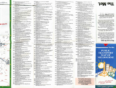
Map, The Met, "Public Transport Map of Melbourne", June 1992
Map - 36 fold - 9 x 2 x 2- colour map of public transport including buses, titled "Public Transport Map of Melbourne", published by the Public Transport Corporation, Effective June 1992. Gives rail and tram maps, information on tickets. Has The Met contact details. 2 copies held .1 - as above but a 6 fold DL, dated Jan 8, 1995trams, tramways, map, ptc, melbourne, the met -
Tatura Irrigation & Wartime Camps Museum
Map - Plaster Cast, Map of Australia, 1940's
Made by POW at Dhurringile Internment CampMap of Australia, plaster cast, bell shaped, in which is a copper penny and a rosella atop Cape York. Dated 1940 words "Tatura Vic" below map of Australia1940 Tatura- Dhurringile intern Campplaster caste, map of australia, layton family, dhurringile camp, tatura, camp, ornament, plaster -
 National Vietnam Veterans Museum (NVVM)
Booklet, British Army, Manual of Map Reading: Air Photo Reading and Field Sketching, Part 1: Map Reading, 1955 (Copy 1), 1955
A red coloured cover with black information. There are signs of possible water damage down the right hand side of the booklet. At the top figth hand reads WO Code No. 8868. Down the spine of the book reads Manual of Map Reading: Air Photo Reading and Field Sketching : 1map reading, air photo reading, manual -
 National Vietnam Veterans Museum (NVVM)
Booklet, British Army, Manual of Map Reading: Air Photo Reading and Field Sketching, Part 1: Map Reading, 1955 (Copy 2), 1955
A red coloured cover with black information. There are signs of possible water damage down the right hand side of the booklet. At the top figth hand reads WO Code No. 8868. Down the spine of the book reads Manual of Map Reading: Air Photo Reading and Field Sketching : 1map reading, air photo reading, manual -
 Bendigo Military Museum
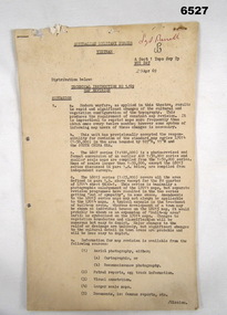
Administrative record - Australian Military Forces Vietnam - Technical Instruction 1/69 - Map Revision, Major EP Constantine, Nui Dat, Vietnam, 29 Apr 1969
This is a Technical Instruction to formalise the Map Revision process at the Royal Australian Survey Corps, A Sect 1 Topo Svy Tp, NUI Dat, Vietnam in 1969. This Instruction details the methods to be used to manage the updating of the current theatre mapping to ensure map users are advised of the latest map changes, either additions or deletions from when the original map was produced.11 x foolscap pages of typed text and diagrams, stapled and two hole punched. Paper dis-colouredHand written top right hand corner in red "Sgt Birrell"royal australian survey corps, rasvy, fortuna, army survey regiment, army svy regt, asr, australian force vietnam -
 Ballarat Tramway Museum
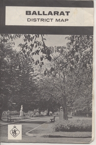
Map, Royal Automobile Club of Victoria, "Ballarat District Map - RACV", c1966
Yields information about the extent of Ballarat in the early to mid 1960's shows the tram lines and other rail lines in the district.Printed street map titled "Ballarat District Map", published by the RACV, showing the central part of Ballarat, Ballarat Outlets, streets, principal attractions, Ballarat and district maps and information, and a list of sporting and entertainment facilities. Has the tram lines shown dotted, does not run out to Sebastopol or the Lydiard St North terminus. Each map in the bottom left hand corner has the numbers "1166", possibly indicating the date.trams, tramways, map, ballarat, racv, railways -
 Melbourne Tram Museum
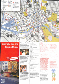
Map, City of Melbourne, "Inner City Transport Map", c1990
Map - 6 fold DL - full colour titled "Inner City Transport Map", providing information for Tourist Information centres, Metlink. Melbourne City Tourist Shuttle, and two maps, one provided by Melway giving a list of attractions. Published by City of Melbourne, Melway and Metlink with each of their logos.trams, tramways, map, public transport, city of melbourne, metlink -
 Dandenong/Cranbourne RSL Sub Branch
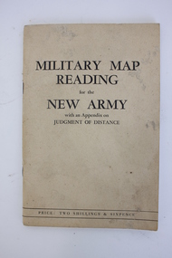
Booklet, Robertson & Mullens Ltd et al, Miltary Map Reading for the New Army with an Appendix on Judgment of Distance, 1941
Beige booklet bound with two staples. White pages within with black illustrations and type. 64 pages.Front: "MILITARY MAP / READING / for the / NEW ARMY / with an Appendix on / JUDGMENT OF DISTANCE / PRICE: TWO SHILLINGS & SIXPENCE"military map reading, orientation, navigation -
Whitehorse Historical Society Inc.
Map, Surrey Hills to Croydon map, c1980
Surrey Hills to Croydon map, Drake & Co Pty Ltd.Surrey Hills to Croydon map, Drake & Co Pty Ltd.Surrey Hills to Croydon map, Drake & Co Pty Ltd.surrey hills, box hill, blackburn, forest hill, vermont, ringwood, mitcham, nunawading, maps -
 Ballarat Heritage Services
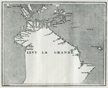
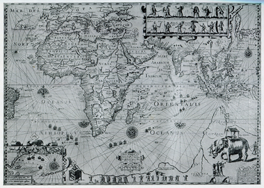
Map, Map of Java La Grande, 1542, 1542
Copy of a map from 'A Short HIstory of Australia' by Ernest Scott.map, chart of the southland, hessel gerritsz, dutch discovery of australiaj.e heres het aandael -
 Ballarat Heritage Services
Map, Map Illustrating Voyage of Ban Neck's Fleet to Dutch East Indies, 1598-1600, 1598-1600
Copy of a map from 'A Short HIstory of Australia' by Ernest Scott.map, van neck's fleet, dutch east indies -
 Ballarat Heritage Services
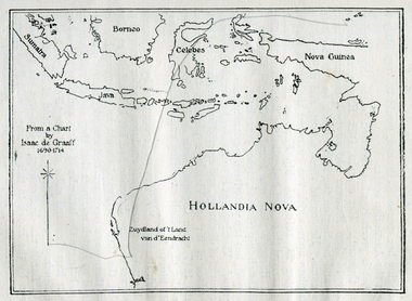
Photograph - Map, Map of New Holland from a chart by Isaac de Graaf (1690-1714), c1714
Copy of a map from 'A Short HIstory of Australia' by Ernest Scott.map, new holland, hollandia nova, isaac de graaff, new guinea, australia of the holy spirit, papua, new hebrides, new zealand, nuyts land, van dieman's land, tasman's track -
Ballarat Heritage Services
Map, Map of Abel Tasman's Voyages, 1642-1644
Copy of a map from 'A Short HIstory of Australia' by Ernest Scott.map, explorers, exploration, abel tasman, voyages -
 Ballarat Heritage Services
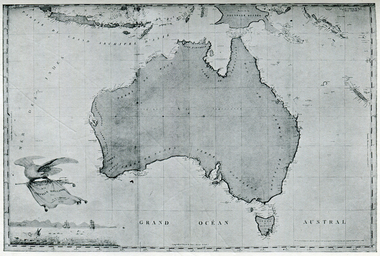
Photograph - Map, Freycinet's Map, Showing 'Terre Napoleon'
Copy of a map from 'A Short History of Australia' by Ernest Scott.map, explorers, exploration, freycinet, terre napoleon, australia -
Southern Sherbrooke Historical Society Inc.
Map, "Melway Melbourne Town & Country Wall Map, Municipal Edition 1983", 1983
Wall map showing municipal boundaries prior to 1995 amalgamations.melbourne -
 Ringwood RSL Sub-Branch
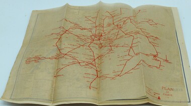
Booklet, Paris map
Map of Paris and info booklet for Englishmen and Americans and toilet guide -
Stawell Historical Society Inc
Map, Plan Shewing Auriferous Deposits and Reefs (Map of Water Races), c1878
Plan Shewing Auriferous Deposits and Reefs (Map of Water Races)stawell, water -
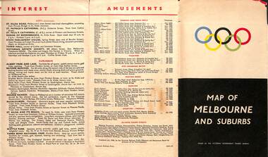 Melbourne Tram Museum
Map, Victorian Government Tourist Bureau, "Map of Melbourne and Suburbs", Jul. 1956
Map - .folded 12 sections full colour titled "Map of Melbourne and Suburbs". Issued at the time of the Melbourne Olympics by the Victorian Government Tourist Bureau. Has an index of Melbourne's suburbs, transport links, Places of Interest, Amusements, Facts of interest about Victoria. Major map shows the rail and tram lines, the detailed map of the CBD shows the buildings or locations referenced in the Tourist Guide to the City. Printed by the Victorian Railways - 2133-56trams, tramways, map, olympics, public transport, melbourne -
Tatura Irrigation & Wartime Camps Museum
Photographs - aerial, Map Data Sciences Pty Ltd, Hill Top Golf Club, 2009
Photographs used for the Centenary of Hill Top Golf and Country Club 2009.A4 images of Hill Top Golf and Country club taken from google photographs. Produced for centenary of Golf in Tatura 2009.hill top golf and country club -
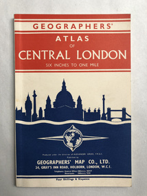 Robin Boyd Foundation
Booklet, Geographers Map Co, Atlas of London
walsh st library -
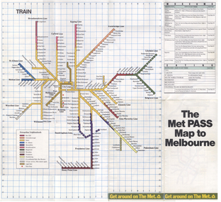 Melbourne Tram Museum
Map, The Met, "The Met PASS Map to Melbourne", c1988/90
Folded Map of Melbourne Rail and Tram lines, titled "The Met PASS Map to Melbourne" Tram Map - probably soon after conversion of the St Kilda and Port Melbourne lines to Light Rail, though these are not shown. Opened November 1987. Rail Map - shows Route 96 north section as Light Rail, co-ordinated bus routes, and the Altona line as going to Werribee. This route was opened in 1985. Date of Map c1988/1990. Has details of Museums, Art Galleries, Shopping, Gardens and Sports Arenas. See also Reg Item 379 for a similar item.trams, tramways, the met, melbourne, maps, tourist tickets -
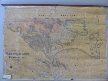 Warrnambool and District Historical Society Inc.
Mao, Borough of Warrnambool, County of Villiers, 1873
This is an early map of the Borough of Warrnambool (1872/3) showing the central town area of Warrnambool and the surrounding district. Reserves, public buildings and some businesses are marked. The map was photolithographed by John Noone, a Melbourne artist and photographer who claimed in 1858 to have the oldest-existing photographic studio in Melbourne. Photolithography was a process first developed in Melbourne. For several years Noone was the official photographer for the Victorian Crown Lands Office and for the Victorian Public Library and Museum. The map has the stamp of the seller of the map – Charles Hider, the well-known stationer and bookseller in Timor Street, Warrnambool. The owner of the map, Henry George Marfell, (1883-1962) was the son of John and Mary Ann Marfell. The Marfells were well-known in Warrnambool as grain merchants and managers of the Warrnambool Co-Operative Milling Company. It is surmised from the writing on the Marfell label that this map was at some stage given by Henry Marfell to the old Warrnambool MuseumThis map of early Warrnambool is of considerable significance, firstly because its original state and early date (1873) make it of antiquarian and historical interest. Also the connection with the names, Charles Hider and Henry Marfell and the old Museum gives it added provenance and interest.This is a wax paper map mounted on cloth. At the top it is attached by nails to a piece of wood and at the top it has a cloth ring for hanging the map. The map is in black shadings on a yellow background. The map is badly creased and coming away from the cloth at the edges and at other various points. There is some red or pink marking or staining on the township area of the map (originally the sold lands on this map were coloured in brown and the reserves, buildings, etc in pink). On the left hand corner there is a piece of paper glued on with some handwriting in ink (Marfell). There is also the stamp of the seller of the map – Charles Hider, stationer and bookseller, of Timor Street Warrnambool‘Early Map of W’bool, H.G. Marfell’ history of warrnambool, charles hider, henry marfell -
 Melbourne Tram Museum
Document, Ministry of Transport, "Travel Smart Map - Port Phillip", 2010
Gives extensive details of walking cycling Public Transport in Port Phillip. Printed 2010. Yields information about Port Phillip transport and other services in 2010Map - pocket - 28 fold - showing walking, cycling and public transport in the City of Port Phillip, using a Melway Map base along with public transport information, Metcard, cycling and walking groups.tramways, melbourne, tram services, bus services, railways, port phillip, cyclists -
Ringwood and District Historical Society
Pamphlets, Vic Roads, Pamphlets about Ringwood Bypass development, and one map. 1991-96, 1991-1996
Pamphlets about Ringwood Bypass development. Qty 6. With one map. -
 Ringwood and District Historical Society
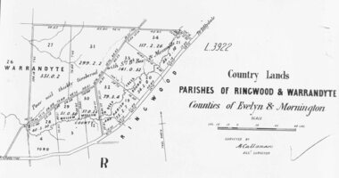
Photograph, Early map of parishes of Ringwood and Warrandyte in Counties of Evelyn and Mornington - c.1868, 1868
Copy of an early map of parishes of Ringwood and Warrandyte, Counties if Evelyn and MorningtonWritten on backing sheet, "c1868. Vol. 5, Fol.13/1224". -
National Vietnam Veterans Museum (NVVM)
Audio - Audio, CD, Coral/Balmoral Map for NVVM
Package contains 1 Audio, CD of the map; paperwork pertaining to the battlevietnam war, 1961-1975 - battlefields - balmoral, vietnam war, 1961-1975 - battlefields - coral -
 Whitehorse Historical Society Inc.
Map, Cadastral map, ca 1955
Cadastral map showing house and lot numbers (ca 1955) in Mitcham.plans, ormond avenue, mitcham, hardwood court, bruce street, page street, victoria avenue, mitcham road, whitehorse road, dunlavin road, doncaster east road, harrison street, william street, alexander street, fellows street, peel street, milne street, albert street, edward street, shirley court, burnett street, haines street -
Whitehorse Historical Society Inc.
Map, Sands and McDougall's Map of Melbourne & Suburbs, 1950s
Wall map of Melbourne and suburbs 12-18 mile radius of CBD.Wall map of Melbourne and suburbs 12-18 mile radius of CBD.Wall map of Melbourne and suburbs 12-18 mile radius of CBD.melbourne, maps -
 Ballarat Tramway Museum
Map, Electric Supply Co. of Vic (ESCo), Ballarat Electoral Map - ESCo, 1900
Document prepared by the Electric Supply Co of Victoria, as part of an order under the Electric Light and Power Act 1896, section 5 of order No. 17 granted to company. Dated 19/2/1901 and signed by the Postmaster-General. Shows the order area being parts of the City of Ballaarat, Sebastopol and Ballarat East. Shows the street names, boundaries, principal power line routes, land reserves, parks, mine locations, railways and Lake Wendouree. Signed by R L Williams Town Clerk City of Ballarat, J R Hall for the Borough of Sebastopol, and John Gent for the Town of Ballarat EastYields information about the power supply to the Ballarat area.Cloth backed paper map, coloured and marked up as exhibit 17.Notes in ink including the signature of Benjamin Deakin 24/9/00 and certified by the three involved municipal Town Clerks.ballarat power supply, esco, electric supply co of victoria, city of ballaarat, east ballarat, sebastopol, orders, power lines, power supply