Showing 360 items
matching grey garden
-
 Bendigo Historical Society Inc.
Photograph - HILDA HILL COLLECTION: BLACK AND WHITE PHOTOS, 1917-1923
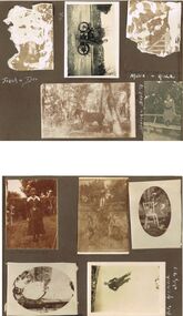
Series of Black & White Photos Total of 10 two severely damaged detailing the life of the Hill family and friends during the war and post World War One.Frank and Dev photo severely damaged. Vin astride an old Indian motorcycle Reg no. 24797, street setting showing gutter dilapidated paling fence further background shows large building with spire. Mollie and Hilda wooden framework of a gateway, severely damaged. Darkie the horse in forested situation 'The Pines' January 1919. Doreen sitting on the backrest of a long seat wearing a dark coloured dress with white collar trees and shrubbery in background. Dora wearing a dark dress with white collar standing in a garden situation , lawn and hedge in background, 'The lawns' 1917. Royston standing in school uniform of dark suit white shirt and dark tie, two younger boys (unnamed) kneeling on the ground both wearing grey suits white shirts and dark ties, all amid long grass, white picket fence and hedge with trees in the background. 'Jock' small terrier or foxy standing on a white chair in front of a palm tree, distant background shows sections of a picket fence. Miss Tovey dressed in white next to a brick wall, to her left fence with hedge at 'The Ranche' 1918.Hal attired in warm dark clothing and wearing a white beanie at Mt Buffalo July 1923.Hilda Hill Personal Collectionaustralia, history, post war life -
 Bendigo Historical Society Inc.
Photograph - HILDA HILL COLLECTION: BLACK AND WHITE PHOTOS, 1919-1924
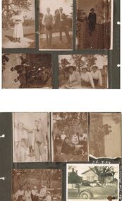
Black & White Photographs Series of 10 depicting life for the Hill Family in 1919, young lady standing near large tree wearing a white dress with black waist sash and dark stockings rear background shows the gable roof and 4 chimneys all behind a large hedge, Durvol December 14 1919 In garden setting man on left wearing grey trousers and what appears to be a bag attached via a string to his waist, grey waistcoat white shirt and dark tie, other gentleman is wearing a dark suit white shirt and dark tie,background shows a hedge and tops of trees, a gable roofed building looms above hedge to centre right, Durvol December 14 1919. Dark photo shows a young lady sitting at the top of a trellis fence, she is wearing dark clothing, her blouse has a white collar, hat with bow above her right shoulder, background shows the tops of two trees, Durvol August 1919. 1 man dressed in dark suit and hat, one boy sitting on the seat, both boys are wearing dark clothing and the boy standing is also wearing long dark socks and boots, the large two wheeled carriage, to the right is a gable roofed shed and top right background a large tree branch, Durvol August 3 1919. 3 ladies seated on the ground first lady on left wears a large brimmed hat with light coloured clothing, other 2 ladies are wearing white blouses and dark skirts each with a light coloured hats. 3 men 2 facing the camera and the other facing to the rear, the front 2 are wearing grey trousers and waistcoats man on right has dark tie and smoking a pipe, man facing the rear wears a hat and grey suit, gable roof of a building is in the background November 29 1919. Group of men and women enjoying a picnic two of the men are seated and both wear dark hats and dark suits with white shirts and dark ties, all of the ladies are wearing hats white blouses, one a light coloured skirt and other 2 dark skirts, bush setting with hill in background, Hibernian Picnic 1919. Four wheeled carriage drawn by one dark horse, the two passengers are dressed in dark suits and hats, a whip is mounted in the front foot well, right background is a standing lady dressed in a white blouse and dark skirt, also tree in left background, 25 July 1924. Group of ladies seated two wearing light coloured hats and all wearing white blouses four are in dark skirts, background is wooded area right background is a post and rail fence, Hibernian Picnic 1919. Old vehicle with five passengers, two ladies in the front one driving and a man and two more ladies in the rear seat, all are wearing dark clothing, gabled roof house in background with white picket fence, left background shows another gable roofed building two chimneys dark appearance.Hilda Hill Personal Collectionaustralia, history, post war life -
 Bendigo Historical Society Inc.
Photograph - HILDA HILL COLLECTION: BLACK AND WHITE PHOTOS, 1921
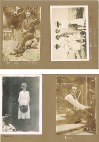
Hilda Hill Collection. Black and White Photos Total of 7 in subset, 3 containing images of Victorian Coastline in particular Pt Lonsdale and Queenscliff in 1921. Another has a family group on a property owned in Kyneton Victoria known as 'Durvol' in October 1920. Ken wearing a grey suit and sitting on a large stone in the garden stargazing, to his left is a short section of a picket fence and ornate corner post, large trees in the background. Four ladies standing on the rock as the seaside, Doreen, Nora, Lila, and Rita, all dressed in white, the second and third are carrying darker coloured coats on their arms, Queenscliff 1921.Leonie dressed in white and holding a black hat with both hands, background shows trellis and weather boards, left foreground may be heap of cut wood. Frank is sitting on steps dressed in white shirt, dark waistcoat, and dark trousers, background is brick wall and handrail attached to the steps. Four ladies in four wheel tourist coach owned by J. L. Priddle, the two at the front are both wearing white, lady to the left also is wearing a dark coat and scarf, the ladies at the rear are both wearing dark tops and the lady on the outer is wearing a white dress. The background appears to be covered on shrubbery. Four ladies sitting on the rocks at Queenscliff February 1921, Three of the ladies are dressed in white, one in a darker colour, all are wearing hats of similar design either black or white. Pone man dressed in a black suit with a white shirt and black tie, the three ladies are all wearing white blouses and darker dresses, the child at the front is dressed entirely in white, Merry??? Durvol October 1920.Hilda Hill Persdonal Collectionaustralia, history, port londsdale & queenscliff, hilda hill ? realted to frank a hill, stock and station agent and hill family real estate. family owned property out at eppalock. could this be where 'the ranch' property was located? -
 Ballarat Tramway Museum
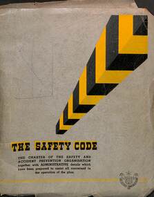
Book - SECV, State Electricity Commission of Victoria (SECV), "The Safety Code", March 1947
Issued by the SECV in March 1947 as a Safety guide or Code of Practice for its employees. Has a forward by the Chairman with a good coverage of Safety Practices of the time, including rules, regulations, statistics, publicity, first aid, general safety, safety equipment, and hints. Item collected by the donor from the Ballarat Tram Depot at the time of closure.Yields information about the Safety Practices of the SEC in 1947 and its methods of educating its workforce.Book - grey covers with Arnos binder holding about 90 duplicated sheets with 14 tab sheets.secv, safety, handbooks, secv rules -
 Ballarat Tramway Museum
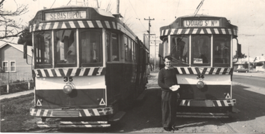
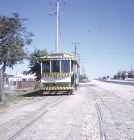
Photograph - Trams 35 & 34 - Last Tram Mail, Keith Kings, 18/1/1979
Black and white photograph of Ballarat trams 35 and 34 standing alongside each other at the Grey St loop on the Sebastopol line with John Fitzsimmons holding some of the last tram mail from Sebastopol to Ballarat on 18/9/1971. Photo by Keith Kings. See item 2942 for a sample of the mail.Yields information about the Last Tram Mail to be carried in Ballarat.Black and white photograph with photographers notes on rear.See image 2trams, closure, last tram mail, tmsv, post office, last tram -
 Ballarat Tramway Museum
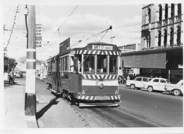
Photograph - Tram 35 - City Centre, c1970
Black and white photograph of tram 35 with the short working destination of Grey St Sebastopol at the tram stop known as the City Centre at Sturt and Lydiard Streets. The pole alongside the tram has the tram stop sign and an End of Section sign. In in the background is the National Mutual building and Allan Bros Jewellers store. Date and photographer unknown.Yields information about tram 35 at the City Centre stop late 1960s or early 1970s.Black and white photograph on plain paper.trams, tramways, tram 35, sturt st, lydiard st, national mutual, city centre -
 Ballarat Tramway Museum
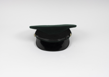
Uniform - SEC uniform Hat, Commonwealth Government Clothing Factories Melbourne, 1960s
All tramway platform crew were issued with a cap and were expected to wear it at all times. Demonstrates uniform cap manufacture.SEC Motorman/Drivers/Conductors cap - green cloth exterior, grey cotton interior lining, brown leather internal hat band, black cotton hat band on exterior with a plastic band at the front half of the cap terminating in two small SEC metal buttons on either side, black plastic beak. Sewn on the inside is a label "Commonwealth Government Clothing Factories Melbourne" and stamped "6 3/8".btm, ballarat tramway museum, conductors, conductors hat, uniforms, sec, conductors cap, motormen, drivers -
 Ballarat Tramway Museum
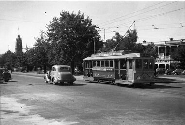
Negative, Wal Jack, 1951
Yields information about the gold tram in service.Negative and Digital image of the Wal Jack Ballarat Negative file of No. 23, as the Gold Tram No. 23 east bound in Sturt St at Dawson St, though it has the destination of Grey St Sebastopol. In the background is the ABC Cafe, selling Swallow's Ice Cream. trams, tramways, sturt st, gold tram, dawson st, tram 23 -
 Ballarat Tramway Museum
Slide - 27 mm sq slide/s, Andrew Howlett, Trams crossing at the Grey St loop in Albert St, Dec. 1969
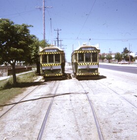
Yields information about the Grey St Loop, Albert St Sebastopol.Colour slide, Kodak white cardboard mount, developed Dec 1969 of No. 36 (Sebastopol) and 41 (Lydiard St Nth) crossing at the Grey St loop in Albert St.ballarat, tramways, trams, sebastopol, grey st, albert st, tram 36, tram 41 -
 Ballarat Tramway Museum
Slide - 27 mm sq slide/s, Andrew Howlett, Tram No. 26 southbound in Albert St, Mar. 1969
Yields information about the Grey St loop and the Sebastopol line.Colour slides, Kodak white cardboard mount, developed March 1969 of No. 26 southbound in Albert St to Sebastopol, running a Special in the Grey St loop waiting for a northbound car. One of a series of tour photos - see Reg item 7667, 7668, 7683 and 7701."Gray St loop Sebastopol"ballarat, tramways, trams, albert st, tours, grey st loop, sebastopol, tram 26 -
 Ballarat Tramway Museum
Photograph - Black and White mounted - Geelong Tram 22 in an accident - 1927
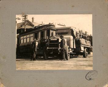
Shows an accident between a Pengelly tram and an AEC solid tyre truck, possibly carrying sacks of coal. Reg Item 8321 shows an accident damaged tram of the same type - tram 22Provides information on the consequences of an accident between a larger heavy truck and a Pengelly tram on 9-2-1927.Mounted Black and White photograph mounted on a grey cardboard, embossed with lines and a decorative pattern of a Geelong Pengelly type tram in collision with an AEC solid tyre truck carrying bagged materials, possibly coal. Has a photographic studio stamp in the bottom right hand corner "C. V. El??". 2nd copy held - on a black plastic copy format.In pencil written under the print "9-2-27 Wed 4.10pm c/o Yarra & Ryrie Sts car going east".geelong, accidents, tram 22, ryrie st, aec trucks, tramways, trams -
 Ballarat Tramway Museum
Photograph - Photo card Ballarat album sheet 1920c
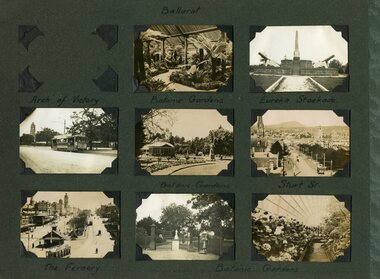
... tramways trams ESCo Sturt St Gardens Eureka Stockade Grey card ...Part of an album of photo cards - cigarette card size - that depicted various country towns c1920. Has photos of the Fernery, Botanic Gardens, Sturt St, Eureka Stockade, and the garden gates with a weighing machine. Possibly published by the Rose Stereograph Co.Demonstrates photo albums and collector type photo cards.Grey card photo album cardboard sheet with teal coloured right hand edge titled "Ballarat" containing 8 small printed photos and "Daylesford" on the other side, though no photos were with the sheet when obtained. See Reg Items 4083 for the bottom left hand corner - from a Rose Stereograph Co. postcard. Each photo has a title on the sheet, though some of them are not correctly located.ballarat, tramways, trams, esco, sturt st, gardens, eureka stockade -
 Ballarat Tramway Museum
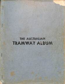
Book, Jack Richardson, The Australian Tramway Album, 1946/47
One of the first books published about Australian Tramway systems. Compiled by Jack Richardson as Editor who went on to publish the Destination series of tramway books. Provides information about the tramcars of each Australian tramway system and some photos and information on USA systems.Demonstrates publishing of magazines and books after the second world war and the work of Jack Richardson.Book - 56 pages, multiple sections with grey covers, stapled and re-stapled, black and white photos.Many corrections, notes marked in blue ink on various pages.books, destinations, jack richardson, traction publications, australia, tramways, ballarat, bendigo, geelong -
 Ballarat Tramway Museum
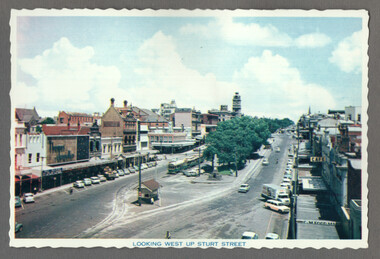
Postcard, Nu-color-vue or Nucolorvue Productions, "Looking west up Sturt Street", 1960s
Postcard showing Sturt St from the building on the north east corner of Sturt and Grenville Sts. Shows three trams in the parking loop, the small shelter and a general view looking west along Sturt St. - 1960sYields information about Sturt St looking west from Grenville St.Postcard - colour with serated edges by Nu-color-vue - No. BT 52. Mounted on a dark grey sheet with another postcard - Nu-color-vue No. BT 69, see Reg Item - 960 and 9304 for an unmounted copy.trams, postcard, sturt st, grenville st, shelters -
 Ballarat Tramway Museum
Sign, State Electricity Commission of Victoria (SECV), "WORKSHOP"
Wooden sign with bevelled edges painted and lettered "WORKSHOP". Background paint would have been white or cream with black letters. has a countersunk hole (off centre) at either end. Rear has been painted grey with cream paint marks.trams, tramways, depot, ballarat -
Ballarat Tramway Museum
Sign, State Electricity Commission of Victoria (SECV), "LOCKERS"
Wooden sign with bevelled edges with word "lockers" painted on an off white or cream back with black lettering. Rear- dark grey.trams, tramways, depot, ballarat -
Ballarat Tramway Museum
Sign, State Electricity Commission of Victoria (SECV), "SAND"
Wood sign with bevelled edges, lettered "sand". Front of sign has an off white or cream background, with letters painted black. Has 2 countersunk holes by "s & d" off centre. Rear is dark grey paint with cream marks from stands.trams, tramways, depot, ballarat -
Ballarat Tramway Museum
Sign, State Electricity Commission of Victoria (SECV), "No Admittance"
Wooden sign with bevelled edges lettered "No Admittance, All Enquiries At Foremans Office"(in caps). Front of sign white background, black letters, back painted in cream colour. Has two holes for mounting to building. Dirty marks, chips etc and some flaking paint. On rear has a bent over nail, some green paint, red paint and a blob of grey "filler" or similar with dirt rings around it and the red paint.trams, tramways, depot, ballarat -
 Ballarat Tramway Museum
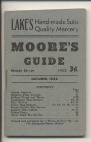
Book, Moore's Guide, "Moore's Guide - Oct. 1952", Sept. or Oct. 1952
68 page book (including covers), timetable for Hobart - airlines, ferry, trams, buses, mail, Trains with various advertisers, known as 'Moore's Guide' - revised edition, price 3d. Blue grey car cover, off white paper and single staple. Record reviewed and scanned images of cover and sample page added 5/9/13.trams, tramways, hobart, timetables -
 Ballarat Tramway Museum
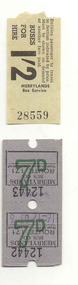
Ephemera - Ticket/s, Merrylands Bus Co. (Sydney) - Wal Jack Collection
3 No. 2 x 7d Solomatic Machine issued bus tickets for Merrylands Bus Co. (Sydney) - see attached sheets - on blue grey paper, 1 No. 1/2d paper flimsy ticket No. 28559 on cream paper. Image of list added 29/9/2013 - see related documents for details.trams, tramways, merrylands bus co., tickets, machine issued tickets -
 Kew Historical Society Inc
Plan, Melbourne and Metropolitan Board of Works, Borough of Kew : Detail Plan No.1580, 1904
The Melbourne and Metropolitan Board of Works (MMBW) plans were produced from the 1890s to the 1950s. They were crucial to the design and development of Melbourne's sewerage and drainage system. The plans, at a scale of 40 feet to 1 inch (1:480), provide a detailed historical record of Melbourne streetscapes and environmental features. Each plan covers one or two street blocks (roughly six streets), showing details of buildings, including garden layouts and ownership boundaries, and features such as laneways, drains, bridges, parks, municipal boundaries and other prominent landmarks as they existed at the time each plan was produced. (Source: State Library of Victoria)This plan forms part of a large group of MMBW plans and maps that was donated to the Society by the Mr Poulter, City Engineer of the City of Kew in 1989. Within this collection, thirty-five hand-coloured plans, backed with linen, are of statewide significance as they include annotations that provide details of construction materials used in buildings in the first decade of the 20th century as well as additional information about land ownership and usage. The copies in the Public Record Office Victoria and the State Library of Victoria are monochrome versions which do not denote building materials so that the maps in this collection are invaluable and unique tools for researchers and heritage consultants. A number of the plans are not held in the collection of the State Library of Victoria so they have the additional attribute of rarity.Original survey plan, issued by the MMBW to a contractor with responsibility for constructing sewers in the area identified on the plan within the Borough of Kew. The plan was at some stage hand-coloured, possibly by the contractor, but more likely by officers working in the Engineering Department of the Borough and later Town, then City of Kew. The hand-coloured sections of buildings on the plan were used to denote masonry or brick constructions (pink), weatherboard constructions (yellow), and public buildings (grey). The area represented in this detail plan has undergone significant change during the 20th century. The widening of High Street in the 1930s and 1950s involved the shops on the south side of High Street being demolished and later rebuilt to fit the widened street. Another significant loss was the mansion ‘Drayton’ fronting Wellington Street, owned at this stage by Susannah Fenton. Her family name would later to be given to Fenton Way, which was to be built over the grounds of the house following its demolition. The plan of the garden is particularly interesting, containing a batten dome fronting Wellington Street, an ornamental pond, a fountain and a brick and glass conservatory. The notes by the plumbing contractor on this plan are particularly detailed. Pink borders delineate the ownership of the varying parcels of land. Some of the better known owners listed include the real estate agent Cr. Henry de Castres Kellett (bt) and John Padbury, the funeral director. This particular plan provides a clear view of the configuration of the Kew Junction in 1903 and the commercial buildings that surrounded it.melbourne and metropolitan board of works, detail plans, maps - borough of kew, mmbw 1580, cartography -
Kew Historical Society Inc
Journal - Visitor Book, Grace Tabulo, Fairyland Lady And Children, 1958-1959
"Fairyland", the home of Jim and Grace Tabulo, was a major local, state and international tourist attraction situated in Kew, Victoria during the mid twentieth century. Located at 57 Malmsbury Street, Kew, the weatherboard house and its garden were heavily decorated with statues, crockery and other collected items. A series of notebooks were used to record the messages of child and adult visitors to the property from the 1940s to the 1960s. After Mrs Tabulo's death, these visitor books are believed to have formed part of the Dorothy Rogers Collection. They entered the Kew Historical Society's collection following her death in 1973.This series of visitor books are the most important primary sources relating to the internationally renowned 'Fairyland' cottage in Malmsbury Street, Kew. Their social significance is that they record in the post war period the values and beliefs of children and adults who visited this historically significant tourist attraction.Foolscap visitor book containing newspaper clippings, handwritten comments and drawings relating to visits to the home of Grace Tabulo, 57 Malmsbury Street Kew, known as Fairyland, June 1958 - April 1959. The book is wrapped in brown paper, which covers a grey card and red cloth strip binding. Creator's title inscription is located under the brown paper on front cover. 120pp. Mrs TABULO/ FAIRYLAND/ LADY/ AND CHILDREN./ c.1959grace tabulo, fairyland - 57 malmsbury street (kew), tourism - kew - 1945-1965, childhood - kew, collectors and collecting, gardens - kew (vic), scrapbooks - 20th century -
Kew Historical Society Inc
Journal - Visitor Book
"Fairyland", the home of Jim and Grace Tabulo, was a notable local, state and international tourist attraction situated in Kew, Victoria during the mid twentieth century. Located at 57 Malmsbury Street, Kew, the weatherboard house and its garden were heavily decorated with statues, crockery and other collected items. A series of notebooks were used to record the messages of child and adult visitors to the property from the 1940s to the 1960s. After Mrs Tabulo's death, these visitor books are believed to have formed part of the Dorothy Rogers Collection. They entered the Kew Historical Society's collection following Dorothy Roger's death in 1973.This series of visitor books are the most important primary sources relating to the internationally renowned 'Fairyland' cottage in Malmsbury Street, Kew. Their social significance is that they record in the post war period the values and beliefs of children and adults who visited this historically significant tourist attraction.A rectangular notebook with a clear plastic front cover and black plastic rear cover with a maroon plastic patch. Unpaginated, approximately 50 loose pale blue-grey pages with red printed lines, held in place by black plastic spine at top edge. The notebook contains handwritten comments and drawings primarily made by children during visits to "Fairyland", at 57 Malmsbury Street, Kew, c.1949. grace tabulo -- fairyland -- 57 malmsbury street -- kew (vic.), tourism - kew - 1945-1965, childhood - kew, collectors and collecting, gardens - kew (vic), scrapbooks - 20th century -
 Kew Historical Society Inc
Plan, Melbourne & Metropolitan Board of Works : Borough of Kew : Detail Plan No.1302, 1910
The Melbourne and Metropolitan Board of Works (MMBW) plans were produced from the 1890s to the 1950s. They were crucial to the design and development of Melbourne's sewerage and drainage system. The plans, at a scale of 40 feet to 1 inch (1:480), provide a detailed historical record of Melbourne streetscapes and environmental features. Each plan covers one or two street blocks (roughly six streets), showing details of buildings, including garden layouts and ownership boundaries, and features such as laneways, drains, bridges, parks, municipal boundaries and other prominent landmarks as they existed at the time each plan was produced. (Source: State Library of Victoria)This plan forms part of a large group of MMBW plans and maps that was donated to the Society by the Mr Poulter, City Engineer of the City of Kew in 1989. Within this collection, thirty-five hand-coloured plans, backed with linen, are of statewide significance as they include annotations that provide details of construction materials used in buildings in the first decade of the 20th century as well as additional information about land ownership and usage. The copies in the Public Record Office Victoria and the State Library of Victoria are monochrome versions which do not denote building materials so that the maps in this collection are invaluable and unique tools for researchers and heritage consultants. A number of the plans are not held in the collection of the State Library of Victoria so they have the additional attribute of rarity.Original survey plan, issued by the MMBW to a contractor with responsibility for constructing sewers in the area identified on the plan within the Borough of Kew. The plan was at some stage hand-coloured, possibly by the contractor, but more likely by officers working in the Engineering Department of the Borough and later Town, then City of Kew. The hand-coloured sections of buildings on the plan were used to denote masonry or brick constructions (pink), weatherboard constructions (yellow), and public buildings (grey). The absence of buildings and or property in Kew facing the Yarra is the most notable feature of this plan. Walmer Street and its bridge stretched, then and now, from Studley Park Road to Victoria Street, Richmond. On the Richmond side of the Yarra, there was evidence in 1904 of industry (‘Wool shed’; Soap Works’) and entertainment (‘Skittle Alley’). In reality, another Plan (No.1303) shows Chinese Gardens bordering the Yarra on the Kew side and buildings in Young Street.melbourne and metropolitan board of works, detail plans, mmbw 1302, cartography -
 Kew Historical Society Inc
Plan, Melbourne & Metropolitan Board of Works : Borough of Kew : Detail Plan No.1563, 1905
The Melbourne and Metropolitan Board of Works (MMBW) plans were produced from the 1890s to the 1950s. They were crucial to the design and development of Melbourne's sewerage and drainage system. The plans, at a scale of 40 feet to 1 inch (1:480), provide a detailed historical record of Melbourne streetscapes and environmental features. Each plan covers one or two street blocks (roughly six streets), showing details of buildings, including garden layouts and ownership boundaries, and features such as laneways, drains, bridges, parks, municipal boundaries and other prominent landmarks as they existed at the time each plan was produced. (Source: State Library of Victoria)This plan forms part of a large group of MMBW plans and maps that was donated to the Society by the Mr Poulter, City Engineer of the City of Kew in 1989. Within this collection, thirty-five hand-coloured plans, backed with linen, are of statewide significance as they include annotations that provide details of construction materials used in buildings in the first decade of the 20th century as well as additional information about land ownership and usage. The copies in the Public Record Office Victoria and the State Library of Victoria are monochrome versions which do not denote building materials so that the maps in this collection are invaluable and unique tools for researchers and heritage consultants. A number of the plans are not held in the collection of the State Library of Victoria so they have the additional attribute of rarity.Original survey plan, issued by the MMBW to a contractor with responsibility for constructing sewers in the area identified on the plan within the Borough of Kew. The plan was at some stage hand-coloured, possibly by the contractor, but more likely by officers working in the Engineering Department of the Borough and later Town, then City of Kew. The hand-coloured sections of buildings on the plan were used to denote masonry or brick constructions (pink), weatherboard constructions (yellow), and public buildings (grey). This plan covers the area between Barkers Road, Wrixon Street, Sackville Street and Brougham Place, much of it now occupied by Carey Baptist Grammar and Preshil schools. This was an area of large and prestigious homes in 1903, some with formally laid-out gardens, such as ‘Tower Hill’ and ‘Opawa’. ‘Kalimna’ was built in 1890-91 for William H. Jarman, an accountant, and ‘Blackhall’ at the same time for W.H. Roberts. Blackhall was to be acquired by the Salvation Army in 1915 and renamed ‘Catherine Booth Girls’ Home’. The Home accommodated girls, aged between 4 and 16. Kalimna and Blackhall are of significance as typical and intact late Victorian mansions and as such are two key Victorian buildings to have been built in Kew. Both Blackhall and Kalimna are now part of Preshil. ‘Fairview’ was for a long time occupied by the Sisters of St. Joseph of Cluny as a care home for the elderly, but it is now part of Carey Grammar School, as are the grounds of ‘Wagga Merne’, ‘Weemutta’, ‘Blakely’, ‘Daheim’ and ‘Mildura’ (later ‘Urangeline’), the last being particularly impressive in 1903, with a tennis court, conservatory, outhouses, and two bathrooms!melbourne and metropolitan board of works, detail plans, mmbw 1563, cartography -
 Kew Historical Society Inc
Plan, Melbourne & Metropolitan Board of Works : Borough of Kew : Detail Plan No.1570, 1905
The Melbourne and Metropolitan Board of Works (MMBW) plans were produced from the 1890s to the 1950s. They were crucial to the design and development of Melbourne's sewerage and drainage system. The plans, at a scale of 40 feet to 1 inch (1:480), provide a detailed historical record of Melbourne streetscapes and environmental features. Each plan covers one or two street blocks (roughly six streets), showing details of buildings, including garden layouts and ownership boundaries, and features such as laneways, drains, bridges, parks, municipal boundaries and other prominent landmarks as they existed at the time each plan was produced. (Source: State Library of Victoria)This plan forms part of a large group of MMBW plans and maps that was donated to the Society by the Mr Poulter, City Engineer of the City of Kew in 1989. Within this collection, thirty-five hand-coloured plans, backed with linen, are of statewide significance as they include annotations that provide details of construction materials used in buildings in the first decade of the 20th century as well as additional information about land ownership and usage. The copies in the Public Record Office Victoria and the State Library of Victoria are monochrome versions which do not denote building materials so that the maps in this collection are invaluable and unique tools for researchers and heritage consultants. A number of the plans are not held in the collection of the State Library of Victoria so they have the additional attribute of rarity.Original survey plan, issued by the MMBW to a contractor with responsibility for constructing sewers in the area identified on the plan within the Borough of Kew. The plan was at some stage hand-coloured, possibly by the contractor, but more likely by officers working in the Engineering Department of the Borough and later Town, then City of Kew. The hand-coloured sections of buildings on the plan were used to denote masonry or brick constructions (pink), weatherboard constructions (yellow), and public buildings (grey). Plan No.1570 shows the layout of gardens and houses in Sackville Street, Davis Street, Wrixon Street, and Fitzwilliam Street in 1904. While Thomas Street is included on the map, at this stage no houses had been built. The plan identifies two named houses: ‘Fairview’ and ‘Kylemore’. Fairview is more fully delineated in Plan No.1563. Kylemore is one of the few houses in Kew designed by John Beswicke. The most notable owner of Kylemore was William Whitehead, who owned the house between 1895 and 1900. In 1894, Australian newspapers reported the marriage of Whitehead’s daughter to Dr. Gerald Eugene Cussen, the brother of Sir Leo Cussen, the Supreme Court Judge. The married couple was to live at ‘Wilton’ (now the Kew RSL) from 1911-15.melbourne and metropolitan board of works, detail plans, mmbw 1570, cartography -
 Kew Historical Society Inc
Plan, Melbourne & Metropolitan Board of Works : Borough of Kew : Detail Plan No.1574, 1905
The Melbourne and Metropolitan Board of Works (MMBW) plans were produced from the 1890s to the 1950s. They were crucial to the design and development of Melbourne's sewerage and drainage system. The plans, at a scale of 40 feet to 1 inch (1:480), provide a detailed historical record of Melbourne streetscapes and environmental features. Each plan covers one or two street blocks (roughly six streets), showing details of buildings, including garden layouts and ownership boundaries, and features such as laneways, drains, bridges, parks, municipal boundaries and other prominent landmarks as they existed at the time each plan was produced. (Source: State Library of Victoria)This plan forms part of a large group of MMBW plans and maps that was donated to the Society by the Mr Poulter, City Engineer of the City of Kew in 1989. Within this collection, thirty-five hand-coloured plans, backed with linen, are of statewide significance as they include annotations that provide details of construction materials used in buildings in the first decade of the 20th century as well as additional information about land ownership and usage. The copies in the Public Record Office Victoria and the State Library of Victoria are monochrome versions which do not denote building materials so that the maps in this collection are invaluable and unique tools for researchers and heritage consultants. A number of the plans are not held in the collection of the State Library of Victoria so they have the additional attribute of rarity.Original survey plan, issued by the MMBW to a contractor with responsibility for constructing sewers in the area identified on the plan within the Borough of Kew. The plan was at some stage hand-coloured, possibly by the contractor, but more likely by officers working in the Engineering Department of the Borough and later Town, then City of Kew. The hand-coloured sections of buildings on the plan were used to denote masonry or brick constructions (pink), weatherboard constructions (yellow), and public buildings (grey). This plan shows several very large houses, particularly along Glenferrie Road, and the area now occupied by Ruyton Girls’ School. ‘Tarring’ (incorrectly spelled here as ‘Karring’) was built for Henry Henty in 1872, on part of his original allotment of 20 acres, and ‘Mount View’, which retains its original building and the fountain in the front garden, is part of Ruyton’s Junior School. The most significant change to Tarring and its grounds since 1903, involve the removal of a number of the outbuildings, including a Burmese temple, bought by Henty from the Burmese Exhibit at the Great Exhibition of 1880. It is shown on the plan as a summerhouse. The two-storey mansion, on the corner of Glenferrie Road and Wellington Street, was built in 1891 by leading architect Alfred White as his own home. Having an initial N.A.V. of £160, the house was purchased by a warehouseman Henry Lister, by 1900, when the N.A.V. was recorded at £111. By the turn of the century the house was known as ‘Comaques’. By contrast, much smaller houses are shown in Scott and Byron Streets, including a tiny Mission Hall in Byron Street, which belonged to the Anglican Church from at least 1903 to 1917.melbourne and metropolitan board of works, detail plans, maps - borough of kew, mmbw 1574, cartography -
 Surrey Hills Historical Society Collection
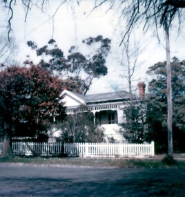
Photograph, 44 Windsor Crescent, Surrey Hills, 1980s
Miss Jessie McCleverty operated a girls' high school at 12 Durham Road from 1903-1905/6. After this time she moved the school to 44 Windsor Crescent where it operated until 1933. Oral testimony from Mrs R McCoy: (NB/ It is unclear whether this refers to 12 Durham Road or 44 Windsor Crescent, but it is more likely to be the later as Mrs McCoy donated a photo taken in 1982 of 44 Windsor Crescent.) "She added school rooms and a veranda to the back. She was keen on Esperanto, the international language and wanted her pupils to know it. There was an archway over the gate, part of the design being a star, part of the Esperanto sign - and some suitable wording. Each morning the pupils greeting had to be "Good Morning Fraternity", in Esperanto."Colour Polaroid photo taken from across the street of an Edwardian-style house, painted white with simple fretwork along the veranda and a picket fence with a simple profile. The roof is grey in colour. It is not possible to tell if it is slate or corrugated iron. The chimney is red brick and the garden has a variety of mature trees.miss mccleverty's girls' school, edwardian style, schools, independent schools, miss jessie mccleverty, windsor crescent, esperanto -
 Surrey Hills Historical Society Collection
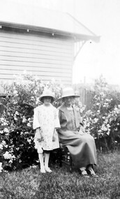
Photograph, Douglas and Jean Sneddon with Alice Keane, 14 Suffolk Road, Surrey Hills
The property was named 'Cliburn' after Cliburn in Westmorland (later Cumbria) where Mary Sneddon's mother, Mary Bird (nee Coulston) came from. According to the donor all their houses were given this name. William Sneddon (b.1875, Sandhurst - d. 1957, Deepdene) was a postman in Surrey Hills for many years. His father James (1833 - 1901) ran an estate agency in Surrey Hills started in the 1880s by his father, also James. William's wife was Mary Sneddon, nee Bird, (b. 1878 Bethunga; d. 1948, Surrey Hills); they married in Surrey Hills in James Sneddon's house on 12 November 1903. They had 5 sons and 1 daughter: John William 'Jack' Sneddon (b.1908 - d. 1957); married Mabel Creek. Norman Alexander Sneddon (b. 1910 - d 1989); married Eva Pearl Sampson. Alan Coulston Sneddon (b. 1914 - d. 1985); married Netta May Clow in 1941. Jean Isobel Sneddon (b. 1916 - d. 1976); married Clifford James Jenkin. Douglas Haig Sneddon (b.1918, Surrey Hills - d. 1973, Blackburn); married Myra Marjorie Clewett in 1945. Relationship with Alice Keane: According to the donor, Alice Ruby Dore married Herbert Keane. She was born 21/9/1901 and died 14/4/1926. Her entries in the Victorian BDM index give that her father was Henry Dore and her mother Sarah Ann Bird and that she was born in Neerim. She married Herbert Henry Keane in 1922; her death at the age of 24 years was registered in Heidelberg. According to the donor her young children Wallace and Phyllis were embraced by William and Mary Sneddon. William and Mary Sneddon are buried in Box Hill Cemetery. The donor Robin da Costa-Adams is related by her first marriage to the Sneddon family. Relationship with Bird family: Netta Sneddon was correct in that Alice Keane was likely a relative. The exact relationship is yet to be fully established. Alice's mother's name is given as Sarah Ann Bird (1873-1952) with birth at Tarrawingee; father John Bird and mother Sarah Ann Coburn (REF: Victorian BDM index). Her notice of marriage in The Age in 1894 states she is "the eldest dau of John Bird of Drouin, late of Box Hill and Talgarno." Has her mother's surname been misspelt? Is it Coulston? Sepia photo of Douglas Sneddon and his sister Jean Sneddon taken in the garden of 'Cliburn', the home of their parents William and Mary Sneddon. With them is with Alice Keane. Part of the house is seen on the RHS of the photo. It is an Edwardian timber home. The profile of the house next door can also be seen in the background."Alice Keane / at / Doug & Jean Sneddon / taken at Sneddons / Surrey Hills" in grey lead pencil in Robin da Costa-Adams' writing. "Children of Mary & / William" "An Alice Keane may be an Aunt (crossing out) - Netta / was not sure" in ink in Jocelyn Hall's hand.suffolk road, 'cliburn', jean isobel sneddon, mrs jean isobel jenkin, douglas haig sneddon, william sneddon, miss mary bird, mrs mary sneddon, box hill cemetery, children, clothing and dress, mrs alice keane, mrs alice ruby keane, miss alice ruby dore -
 Surrey Hills Historical Society Collection
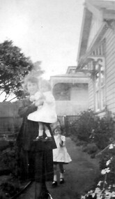
Photograph, Mary Sneddon with daughter Jean
The photo was taken in the garden of of 'Cliburn', 14 Suffolk Avenue, Surrey Hills, the home of William and Mary (nee Bird) Sneddon. It was named after Cliburn, Westmorland (later Cumbria) where Mary's mother was born and the name was given to all their homes. Mary Bird, daughter of John Bird and Mary Coulston, b 1878 Bethanga, Victoria; died 1948, Surrey Hills. They were married on 12/11/1903 in Surrey Hills at the home of James Sneddon. William Sneddon was a postman in Surrey Hills for many years. His father James had an estate agency in Surrey Hills from the 1880s. Born in1875, Sandhurst (Bendigo); died in 1957, Deepdene. Buried Box Hill Cemetery: P-061-0033. They had the following children: Jim (James 3rd) b 1905, Balwyn Jack (John William) b. 1908, Camberwell Norman Alexander b 1910, Camberwell Alan Coulson b 1914 Surrey Hills Jean Isabel b 1916, Surrey Hills Douglas Haig b 1918, Surrey Hills. Additional information from Robin da Costa-Adams, who is related to the Sneddon family through her first marriage. Sepia photo of Mary Sneddon with daughter Jean wearing hats and taken in a garden. Mary is seated and Jean stands beside her. Part of the house next door can be seen in the background. It is an Edwardian timber home"Jean Sneddon / Mary Sneddon/ (in grey lead pencil by Robin da Costa-Adams. 1050 in blue biro crossed out in top RH corner. KODAK PRINT - black stamp in centre. "Jean dau of Mary - / Will. Sneddon" in black ink in Jocelyn Hall's hand. cliburn, suffolk road, (miss) jean sneddon, william sneddon, (mrs) mary sneddon, (miss) mary bird