Showing 6746 items
matching gullies
-
 Bendigo Historical Society Inc.
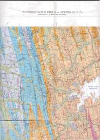
Map - STRUGNELL COLLECTION: GEOLOGICAL SURVEY OF VICTORIA, BENDIGO GOLD FIELD - SPRING GULLY, 1987
Map, Geological Survey of Victoria, Bendigo Gold Field - Spring Gully, Campaspe 10 000 2/1; Victoria 10,000.Cept. Of Industry, Technology & Resources.map, bendigo, spring gully gold field -
 Bendigo Historical Society Inc.
Map - SANDHURST (PART), Circa 1880's
Map: Parish plan showing an area from McKenzie/View streets to Long Gully ( number 232 in Map Cupboard 1)map, bendigo, parish plan, sandhusrt, mckenzie street , view street, long gully -
 Lakes Entrance Regional Historical Society (operating as Lakes Entrance History Centre & Museum)
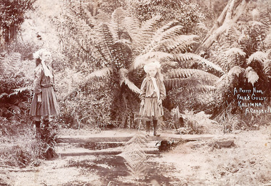
Photograph, Arthur Cooper, 1909c
Sepia toned photograph of Bertha and Gladys Falk as children standing by a stream in a fern gully at Falk's property Kalimna West Victoriagenealogy, agriculture -
 Maryborough Midlands Historical Society operating the Worsley Cottage Museum
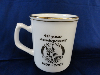
Souvenir mug, 2002
Cream ceramic mug with gold rim and lettering. Celebrates the 40 year anniversary of California (Cal) Gully kindergarten (1962-2002) The names of 57 children enrolled in 2002 plus the teacher (Julie Lebkowski) and assistant (Pauline Coburn) are inscribed on the mug. -
 Bendigo Historical Society Inc.
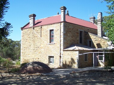
Document - Rocky Vale Beebe House, 2010 to 2015
The Beebe name was well-known in Bendigo in the last quarter of the 19th and the early part of the 20th centuries. From 1875, William Beebe senior, monumental mason, occupied a site in the centre on the city, in Mitchell Street opposite King Street. Death was more part of life in those days, and the Beebes were there to provide the burial monuments. Later, he took his sons into the business, which grew as Beebe and Son. Many examples of their work can be found in the local cemeteries. William Beebe senior (1830-1891) was born in Rutland, the smallest English county in 1830, to stonemason Chamberlain Beebe and Susannah Clements. William emigrated to Victoria in 1854 and after engaging on unknown works in Port Fairy, Dunkeld, and Melbourne arrived in Bendigo. His obituary records that he commenced work here on the site of the Bank of Australasia (opposite the Shamrock Hotel), which would have been no later than 1856. He took up a 13 acre selection on the site of Rocky Vale Villa in 1864 and continued to select or purchase further parcels of adjoining land until he owned some 150 acres, much of it unfit for cultivation. He was a keen gardener and had a garden and orchard around the house. William took over 20 years to build the two-story sandstone and granite house "Rocky Vale Villa". The house was constructed from sandstone sourced "from an adjacent ridge of rocks" (Bendigo Advertiser 28/9/1891). Granite from Harcourt was used for lintels and quoins. Not long before he died, William was still adding to the house. In the Codicil to his will, he states that "I have just built and completed two additional rooms to my Dwelling house situe at Inglewood Road aforesaid" (dated 19/9/1891). William died one week later on the 26th September 1891.Photographs and Historical Documents relating to Rocky Vale Villa, 7 Wicks Road, Maiden Gully, Bendigo by the Bendigo Historical Society.history, bendigo, rocky vale villa maiden gully, william beebe stonemason bendigo -
 Bendigo Historical Society Inc.
Document - NOTES ON BENDIGO MINES
Handwritten notes on Bendigo Mines. Notes include area of lease, yards along the reef, depth, dividends, main shafts within one mile of Bendigo Station and shafts made safe by the Mines Dept. Mines mentioned are: South New Moon, Carlisle, Nth Garden Gully, Passby, Old Carlisle,Kentish, Central Garden Gully, Golden Fleece, Garden Gully United, Big Blue, Union Co, Red, White & Blue, New Chum Railway, Unity, Cornish, Catherine Reef United, Garden Gully United, Gt Extended Hustlers, Gt Northern, Lady Barkly, New Moon, South St Mungo, Virginia and Victoria Quartz, Document from Albert Richardson Collection of mining history.document, gold, notes on bendigo mines, notes on bendigo mines, south new moon, carlisle, nth garden gully, passby, old carlisle, kentish, central garden gully, golden fleece, garden gully united, big blue, union co, red, white & blue, new chum railway, unity, cornish, catherine reef united, garden gully united, gt extended hustlers, gt northern, lady barkly, new moon, south st mungo, virginia, victoria quartz, graham, tenby and ashman, mr j b watson, geo lansell, mines dept, d e thomas -
 Greensborough Historical Society
Map, Melbourne and Metropolitan Board of Works. Survey Division, MMBW, Yarra 2500 / 16.26. Diamond Creek, Broadgully Road, 1978_07
Melbourne and Metropolitan Board of Works. Yarra 2500 [base map] 16.26. Diamond Creek, Broad Gully Road. Municipalities of Diamond Valley 257 and Eltham 238. Prominent streets include: Wadeson Road, Broad Gully Road and Glenhaven Road. Features include the Diamond Creek.MMBW Map in 1:2500 [scale] series. Cream parchment with green tape reinforcing on edges and punched holes on left edge.mmbw, melbourne and metropolitan board of works, shire of diamond valley, diamond creek - maps -
 Bendigo Historical Society Inc.
Document - LONG GULLY HISTORY GROUP COLLECTION: LONG GULLY UNITING CHURCH
Typed page titled Historical - Long Gully Uniting Church. It was compiled by Fred Straub, Secretary, Long Gully Seniors for Seniors Week Recital 30/3/1993. The foundation stone was laid in 1857 and the church was built in two stages. There is a brief description of the building. There is also a description of the pipe organ which was installed in 1882.bendigo, history, long gully history group, the long gully history group - long gully uniting church, long gully methodist church, alfred fuller, the organ society of victoria, fred straub -
 Bendigo Historical Society Inc.
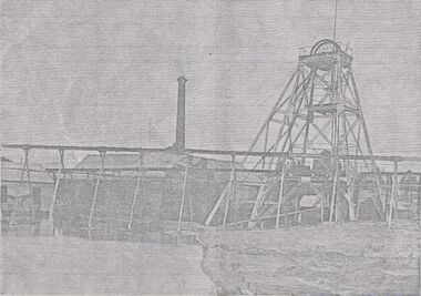
Photograph - GARDEN GULLY UNITED MINE
Photocopy of photograph : poppet head, conveyors, shedding and chimney - Garden Gully United Mine. Printed on top of photocopy ' Mine Managers' Association, Bendigo goldfields On bottom of photocopy ' The Garden Gully United Company's Mine' James Lerk 26.22 1999 ' this poppet head is now on the top of Camp Hill. On back Mng 67.organization, business, garden gully united mine -
 Bendigo Historical Society Inc.
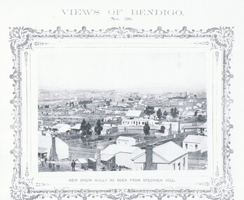
Photograph - VIEWS OF BENDIGO: NEW CHUM GULLY AS SEEN FROM SPECIMEN HILL, 1875 Copy,1970
Sepia photo on cream board. Shows mostly houses in New Chum Gully from Specimen Hill. Inscription: 'Views of Bendigo No 36.'. Below, 'New Chum Gully as seen from Specimen Hill', 'N.J.Caire Photo, Sandhurst'. Bottom, 'Casey & Wenborn's Print Forbes & Holmes, Agents' (Two copies) Nicholas CaireN.J.Caireplace, bendigo, new chum gully, see: 'views of bendigo' by n.j.caire, 'mp156' -
 Bendigo Historical Society Inc.
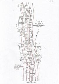
Document - BENDIGO GOLD MINING PLAN OF LEASES, CENTRAL AREA
One page document with a diagram showing reef lines and lease holdings in the central area of the Bendigo Goldfield. Reef lines shown are Sheepshead Line, Deborah Line, Garden Gully Line, Paddy's Gully Line, Hustlers Line. Sourced from Bendigo Goldfields Library, Central area. CD Rom 622.3422 BENbendigo, mining, lease holdings and reef lines -
 Bendigo Military Museum
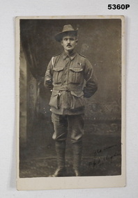
Photograph - PHOTOGRAPH 38TH BN, C.1918
Photo is; Robert John Milligan No 1877 enlisted 3.3.1916 age 34 in 2nd reinforcements 38th Bn, embarked for England 16.8.1916, due to getting into trouble he does not embark for France until 3.1.1918, WIA 30.8.1918 GSW to Arm and Thigh, discharged from the AIF 20.3.19120Postcard photo sepia tone showing a soldier standing hands behind back, has Sergeants stripes on one arm, studio background, inscription on front.On front in black, “Yrs sincerely R.J.Milligan”, On rear in pencil, “R.J. Milligan C/- J. Milligan Maiden Gully”photographs, 38th bn, -
 Bendigo Military Museum
Book, Claim for Special Allowance to Ex-Prisoners of War 1939-45
The book belonged to George Llewellyn Thomas VX58918 2nd AIF, POW. Refer 1075 for service history also 1073.2, 1074P. Soft cover book. Cover is cardboard. Book binding brown ..cloth tape with staples. Covers fawn coloured.Black printing on front cover. 131 pages, paper cut, plain & off white Inside cover on first page handwritten blue ink " G.L.Thomas./7 Creeth St./Long Gully,/Bendigo" book, history -
 Bendigo Military Museum
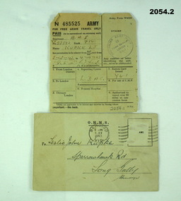
document - ARMY DOCUMENTS WW2, WWII
2054.1) Travel pass issued to L. J. KUPKE whilst attached to Australian Army Staff in London in 1947. 2054.2) Issued to L. J. KUPKE VX93892 requesting that he report for a medical examination in Bendigo on corner of Pall Mall and Bull St. Leslie John KUPKE initially signed Mobilization forms on 12.7.1943 as No V513056 age 18 years. He then transferred to the AIF on 3.12.1943 as No VX93892. He embarked for Bougainville with the the 15th Aust Infantry Battalion on 23.11.1944, hospital with Hookworm from 8.6.1945 to 30.6.1945, embarked for Australia returning on 1.6.1946, hospital with Malaria on 17.8.1946. On 21.1.1947 he embarked for England as a POW voyage guard and returned on 14.6.1947. Discharged from the Army 1.7.1947..1) Free leave travel pass issued to L. J. KUPKE VX93892. Army form W4098. .2) Notice to report for Medical Examination..1) Stamped by Australian Army Staff .2) Addressed to Leslie John KUPKE, Sparrowhawk Rd. Long Gully.documents-army records, travel -
 Ringwood and District Historical Society
Photographs, 1979-80 MMBW pipe line project at Hubbard Reserve, North Ringwood � View east up the gully
Part of a 43-photo record of the MMBW�s engineering feat in drilling a 12 inch pipe line up to 40 feet deep through rock hardened by volcanic action associated with geological fault that occurs along the line. The work took place from October 1979 to May 1980 on the southern boundary of Hubbard Reserve, North Ringwood. The collection was presented to the Ringwood Historical Research Group by J Clarke on 9th June 1980.E568 N19 13 May 1980 A43 View east up the gully, when all the work was finished -
 Eltham District Historical Society Inc
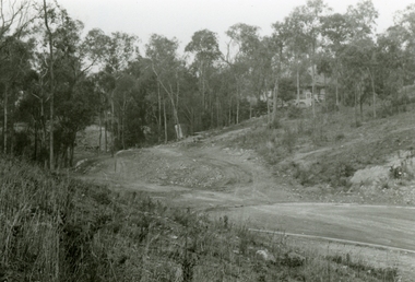
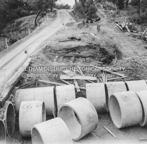
Album - Photograph, J.A. McDonald, Heidelberg-Kinglake Road, c. 1956
Bridge over Cherry Tree Gully demolished Pipes in place c. 1956Record of various Shire of Eltham infrastructure works undertaken during the period of 1952-1962 involving bridge and road reconstruction projects, sometimes with Eltham Shire Council Project Reference numbers quoted. It was during this period that a number of significant improvements were made to roads and new bridges constructed within the shire that remain in place as of present day (2022). In many situations, the photos provide a tangible visible record of infrastructure that existed throughout the early days of the Shire. The album was put together by or under the direction of the Shire Engineer, J.A. McDonald.infrastructure, shire of eltham, 1956, bridge construction, heidelberg-kinglake road, road construction, cherry tree gully -
 Federation University Historical Collection
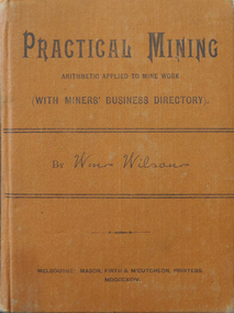
Book, Practical Mining, 1894, 1894
William Wilson was the librarian at the Mechanics' Institute and Public Library, Long Gully, Bendigo.Small, orange, hardbound book, Includes a Miners' Business directory with many advertisements from Bendigo suppliers.mining, william wilson, decimal arithmetic, measurement of timber, steam boilers, pumps, ventilation, bendigo -
Stawell Historical Society Inc
Realia, 2 Bricks from Pe-existing structure in Mt. William Creek
From 370 Long Gully Rd. Jallukar/ Pomonal, near Redmans RoadOne Large red fired brick shaped with a curve. One broken half brick with T Taylor stamped into FrogImpressed in Frog of Brick T Taylor -
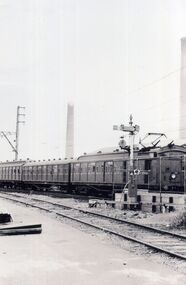 Whitehorse Historical Society Inc.
Photograph, Electric Passenger trains
The Ringwood line was electrified in 1922 and extended to Lilydale and Fern Tree Gully in 1925An early black and white photograph of a passenger train heading West towards the city. Australian Tesselated Tile chimney in the background.electric trains, passenger trains, railways -
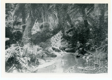 Mt Dandenong & District Historical Society Inc.
Photograph, The Olinda Creek, 1910
The Olinda Creek in 1910. Most probably in the gully behind the house of George Barber.Black and white photograph with a creek running through the centre of ferns and tree ferns. A man sits beside the creek on the RHS.olinda creek -
 Mt Dandenong & District Historical Society Inc.
Photograph, The Olinda Creek, 1910
Taken in 1910, this section of the Olinda Creek is in the gully behind the home of George Barber.Black and white photograph with a creek running through the centre surrounded by ferns and tree ferns. A man is leaning on rocks beside the creek on the RHS.olinda creek, creek, george barber, tree fern -
Bendigo Historical Society Inc.
Document - PADDY'S GULLY LINE - VIRGINIA CONSOLS MINE
Handwritten page of notes on the Virginia Consols Mine on Paddy's Gully Line of Reef. Notes mention shaft being cleaned out and timbered to 100 ft. Also depth of work, timbering and geological features. Also a small piece of paper with:- Virginia Consols Mine 2 miles North of E'hawk Town Hall. Paddy's Gully Line.document, gold, paddy's gully line, paddy's gully line, virginia consols mine, e'hawk town hall -
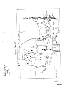 Bendigo Historical Society Inc.
Document - LONG GULLY HISTORY GROUP COLLECTION: THE LONG GULLY GOLF LINKS
Some history of the Long Gully Golf Links, a 9 Hole Course, by John Harvey. First page has a map of the area showing where the holes are and different features. There is a description of the tees and the route taken around the course.Dates when the Eaglehawk, Neangar park, Kangaroo Flat Golf Clubs and the Long Gully Playground were opened.bendigo, history, long gully history group, the long gully history group - the long gully golf links, a crossley, john harvey, long gully rec, dai gum san reservation, quarry hill golf club, bendigo golf club, marong gulf club, miss colgan, sacred heart cathedral choir, mechanics institute, rose of australia hotel, north hercules and energetic mine site, les thomas, tom austen, pearl south mullock heap, doc catford, clubs wearne, pearl mining co's diggings, pearl south, pearl east, bill and faye osterfield, ellen lee osterfield, eaglehawk gold club, neangar park golf club, f m fitzpatrick, kangaroo flat golf club, long gully playground, pearl sands, ennor brothers, birchmore brothers, shirley harvey, belvoir park, harold ennor, george ennor -
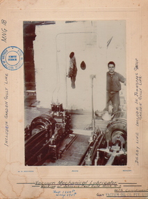 Bendigo Historical Society Inc.
Photograph - JOHNSON'S REEF GOLD LUBRICATOR, c.1880-1890
Vacuum mechanical Lubricator Machinery (vacuum mechanical working at Johnson's Reef Gold, Mine No. 3. Lubricator. Man standing to RH side, hand on lever. Photo mounted on board. Inscriptions: included in Garden Gully Lane MNG18. Derby Line, included in Johnson's Group of Garden Gully Line. Shaft 1250ft. Winze 175ft.place, mining site, johnson's reef -
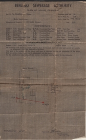 Bendigo Historical Society Inc.
Document - JOAN LEVERSHA COLLECTION: BENDIGO SEWERAGE AUTHORITY PLAN HOUSE DRAINAGE
Bendigo Sewerage Authority plan of house drainage for Mr Douglas Dean, situation of property: weatherboard dwelling, 26 Bolt Street, Long Gully. Drainage plan no.35, Detail plan No. 134, retic. area No. long Gully. fee 7/6. Scale 40 feet to 1 inch. Dated 30/08/1954.organisation, government, bendigo sewerage authority -
 Bendigo Historical Society Inc.
Document - LONG GULLY HISTORY GROUP COLLECTION: LONG GULLY NAMES STREET BY STREET
Five pages of copies of residents of streets in Long Gully including Derwent Gully, Sparrowhawk and St Just Point. Numbers beside names are possibly street numbers. Street names have E Side, W Side, N Side or South Side. These pages have been photocopied from a street directory. Date unknown.bendigo, history, long gully history group, the long gully history group - long gully residents street by street, derwent gully, sparrowhawk, st just point -
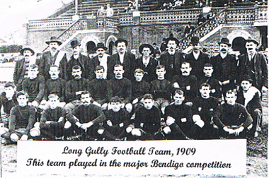 Bendigo Historical Society Inc.
Photograph - LONG GULLY HISTORY GROUP COLLECTION: LONG GULLY FOOTBALL TEAM 1909
Copy of a black and white photo of the Long Gully Football Team, 1909. Photo taken in front of a brick Grandstand. All the men in the back row are wearing suits and various types of hats. The others are wearing football attire. Label pasted on the photo - Long Gully Football Team, 1909. This team played in the major Bendigo competition.bendigo, history, long gully history group, the long gully history group - long gully football team 1909 -
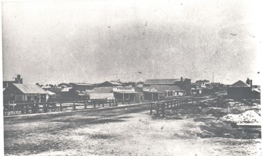 Bendigo Historical Society Inc.
Photograph - HARRY BIGGS COLLECTION: LONG GULLY TOWNSHIP
Photograph. Harry Biggs Collection. 1 black & white photo of Long Gully township looking from Eaglehawk towards Bendigo near the bridge. On 1 shop can be seen P Pentreath. A wooden bridge can be seen over the creek. Long Gully Township looking from Eaglehawk to Bendigo near bridge (written on the back).photograph, streetscape, long gully, harry biggs collection, long gully township -
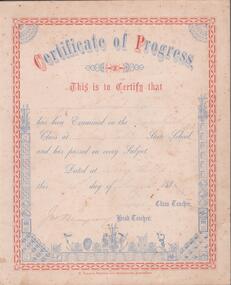 Bendigo Historical Society Inc.
Certificate - CERTIFICATE OF PROGRESS
Certificate of progress. This is to certify that Samuel New has been examined in the lower fourth class at Long Gully State school and has passed in every subject. Dated at Long Gully this 14th day of August 1884. E. Lewis school teacher. J,M, Blaupany (?) head teacher. Printed by W. Holmes, printer and bookbinder, Sandhurst.education, bendigo, long gully -
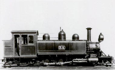 Puffing Billy Railway
3A, Victorian Railways NA Class Steam Locomotive, 1900
3A Built in 1900. This is the second locomotive to be built at the Victorian Railways Newport Workshops. Painted in the then standard Victorian Railways two-tone green, this locomotive was issued to the Upper Ferntree Gully to Gembrook line and was used on the line’s construction. Over the years, it saw service on the Colac to Crowes and Moe to Walhalla lines, but it saw more service on the Gembrook line than any other. It was withdrawn from service in 1955 at Upper Fern Tree Gully and sold in 1960 to the Lord Mayor’s Camp at Portsea where it remained on static display until obtained by the Puffing Billy Presservation Society in 1977. Number 3A Entered service 6th april 1900 Livery two-tone green Gauge 762mm / 2' 6" Service History : Apr 1900 UFTG. - initial allocation Apr 1900 - Jul 1901 Upper ferntree gully Feb 1902 - Jan 1906 Colac Feb 1906 - Jul 1906 Upper ferntree gully Sep 1907 - Mar 1908 Colac Oct 1908 - Oct 1909 Upper ferntree gully Nov 1909 - Apr 1910 Other Oct 1910 - Nov 1911 Upper ferntree gully Feb 1912 - Oct 1914 Colac Dec 1914 - Oct 1917 Moe Dec 1917 - Jul 1920 Colac Sep 1920 - Jun 1922 Moe Jul 1922 - Jun 1925 Upper ferntree gully Aug 1925 - Mar 1928 Other May 1928 - Nov 1929 Moe Jan 1930 - Apr 1935 Wangaratta Jun 1935 - Sep 1936 Workshops Oct 1936 - May 1949 Upper ferntree gully Nov 1949 - Mar 1950 Workshops Apr 1950 - Jun 1955 Upper ferntree gully Nov 1955 - Mar 1959 Workshops Nov 1960 - Aug 1973 Lord Mayor’s Camp at Portsea Apr 1977 - salvaged from Lord Mayors camp and delivered to Menzies creek station.Victorian Railways - Narrow Gauge NA class steam locomotive number 3A Victorian Heritage Register (VHR) Number H2187 Dates that 3A worked on the Upper ferntree gully to Gembrook Line. Apr 1900 - initial allocation of a new locomotive Apr 1900 to Jul 1901 Feb 1906 to Jul 1906 Oct 1908 to Oct 1909 Oct 1910 to Nov 1911 Oct 1936 to May 1949 Apr 1950 to Jun 1955 Apr 1977 to Belgrave Steam Locomotive3Apuffing billy, victorian railways, 3a, narrow gauge, steam locomotive