Showing 606 items matching "heritage - (vic.)"
-
 Koorie Heritage Trust
Book, Brown Eileen M, Early Wahgunyah and Corowa from 1839, 1968
People and places from old or early Wahgunyah and Corowa from 1839 onwards.19 P.; ports.; 25 cm.People and places from old or early Wahgunyah and Corowa from 1839 onwards.wahgunyah -- history. | wahgunyah (vic.) -- history. | corowa (n.s.w.) -- history. -
Whitehorse Historical Society Inc.
Article, Volunteers set to work on heritage grounds, 2006
Volunteers to be enlisted to restore historic Crown Land abutting Schwerkolt Cottage, known as 'The Horse Paddock' (photo)Volunteers to be enlisted to restore historic Crown Land abutting Schwerkolt Cottage, known as 'The Horse Paddock' (photo) Judith Fry, Barbara Gardiner, Rob Hulls (Vic Planning & environment Minister), Sharon Ellis (Whitehorse Mayor)Volunteers to be enlisted to restore historic Crown Land abutting Schwerkolt Cottage, known as 'The Horse Paddock' (photo)voluntary workers, schwerkolt cottage, hull, rob, ellis, sharon, fry, judith, gardiner, barbara -
 Dandenong/Cranbourne RSL Sub Branch
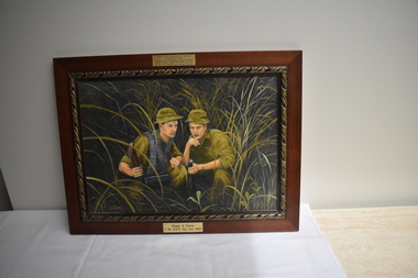
Painting - Ziggy & Garry. 7Bn RAR. Nui Dat 1967
Painting by B Watt. Painting of Two Soldiers (Ziggy &Garry} dressed in jungle greens holding weapons in Nui Dat Vietnam 1967On top of frame -Donated to the Dandenong RSL Sub Branch in Dandenong Victoria- In Memory of hr. Dr Zygmunt A.Gizycki de Gozdawa .M.D,D,S.(Poznan-Poland) B.D,Sc (Melb) L.D.S (Vic) By Gizycki de Gozdawa Family Heritage Foundation.---- On bottom of frame-Ziggy Garry 7 Bn R.A.R. Nui Dat 1967. -
 Ballarat Heritage Services
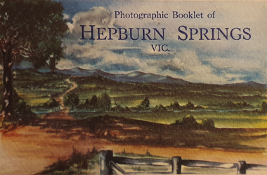
Postcard - Postcard Booklet, Photographic Booklet of Hepburn Springs, Vic, c1945
Hepburn Springs in a tourist town with natural mineral water springsA colour tourist booklet with 8 black and white images of scenes in Hepburn Springs. hepburn springs, blowhole, suspension bridge, mineral sptings hotel -
 Ballarat Heritage Services
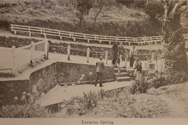
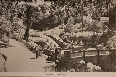
Souvenir - Postcard Booklet, Locarno Springs from Photographic Booklet of Hepburn Springs, Vic, c1945
Hepburn Springs in a tourist town with natural mineral water springsA black and white photographic image of Locarno Spring in the Hepburn Springs Mineral Springs Reserve. hepburn springs, locarno mineral water spring, mineral water, locarno spring -
 Ballarat Heritage Services
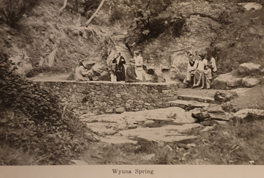
Souvenir - Postcard Booklet, Wyuna Spring from Photographic Booklet of Hepburn Springs, Vic, c1945
Hepburn Springs in a tourist town with natural mineral water springsA black and white photographic image of Wyuna Spring in the Hepburn Springs Mineral Springs Reserve. hepburn springs, mineral water, wyuna spring -
 Ballarat Heritage Services
Souvenir - Postcard Booklet, Locarno Springs from Photographic Booklet of Hepburn Springs, Vic, c1945
Hepburn Springs in a tourist town with natural mineral water springsA black and white photographic image of Locarno Spring in the Hepburn Springs Mineral Springs Reserve. hepburn springs, locarno mineral water spring, mineral water, locarno spring -
 Ballarat Heritage Services
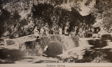
Souvenir - Postcard Booklet, Sulphur Springs from Photographic Booklet of Hepburn Springs, Vic, c1945
Hepburn Springs in a tourist town with natural mineral water springsA black and white photographic image of Sulphur Spring in the Hepburn Springs Mineral Springs Reserve. hepburn springs, mineral water, sulphur spring -
 Ballarat Heritage Services
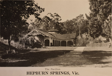
Souvenir - Postcard Booklet, Hepburn Springs Pavilion from Photographic Booklet of Hepburn Springs, Vic, c1945
Hepburn Springs in a tourist town with natural mineral water springsA black and white photographic image of the pavilion in the Hepburn Springs Mineral Springs Reserve. hepburn springs, mineral water, pavilion -
 Ballarat Heritage Services
Souvenir - Postcard Booklet, Bridge Over Spring Creek from Photographic Booklet of Hepburn Springs, Vic, c1945
Hepburn Springs in a tourist town with natural mineral water springsA black and white photographic image of a metal spring in the Hepburn Springs Mineral Springs Reserve. hepburn springs, mineral water, bridge -
 Ballarat Heritage Services
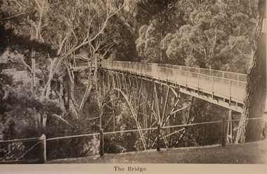
Souvenir - Postcard Booklet Image, Suspension Bridge Over Doctors Gully from Photographic Booklet of Hepburn Springs, Vic, c1945
Hepburn Springs in a tourist town with natural mineral water springsA black and white photographic image of a suspension bridge over Doctors Gully, Hepburnhepburn springs, suspension bridge, doctors gully -
 Ballarat Heritage Services
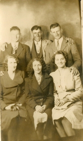
Image - Black and White
Six people in the photograph. Back row left to right: Vic Quanchi, Tony Saligari, Allan Wynd Front row left to right: Molly Maffesoni, Annie Gervasoni, Rene Gervasoni (later Saligari)vic quanchi, tony saligari, allan wynd, molly maffesoni, annie gervasoni, rene gervasoni, rene saligari -
 Ballarat Heritage Services
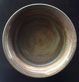
Ceramic - Wheel Thrown Stoneware Bowl
Belltower Pottery was established by Rudolf Dybka in Kyabram, Victoria, in around 1977 with the help of John Stroomer. Stroomer later took over the pottery, employing as many as 23 workers and apprentices. After a fire in 1988 destroyed the building, Stroomer moved the pottery to the old Kyabram butter factory, where it operated until the late 1990s. Works may be marked with an impressed 'Belltower Pottery' or, after the move to Kyabram, 'Belltower Pottery, Handmade, Kyabram, Vic.'Wheel thrown stoneware bowl with the word 'Nuts' on one side. Stamped "'Belltower Pottery, Handmade, Kyabram, Vic"pottery, belltower pottery, kyabram, australia studio pottery -
 Ballarat Heritage Services
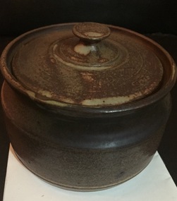
Ceramic - Image, Belltower Pottery, Lidded Wheel Thrown Bowl, c1995
Belltower Pottery was set up by Rudolf Dybka in Kyabram, Victoria, in around 1977 with the help of John Stroomer. Stroomer later took over the pottery, employing as many as 23 workers and apprentices. After a fire in 1988 destroyed the building, Stroomer moved the pottery to the old Kyabram butter factory, where it operated until the late 1990s. Works may be marked with an impressed 'Belltower Pottery' or, after the move to Kyabram, 'Belltower Pottery, Handmade, Kyabram, Vic.'Wheel thrown stoneware bowl with the word 'Nuts' on one side. pottery, belltower pottery, rudolf dybka, john stroomer -
Ballarat RSL Sub-Branch Inc.
Magazine Article
This object relates to Sir Leslie James MORSHEAD. He was born on 18/09/1889 in Ballarat, VIC. Sir Leslie James served in the ARMY AIF (NX8) enlisting on, 09/09/1914 in Ballarat, VIC before being discharged from duties with the ARMY AIF as a RL (GEN LIST) 2 MD on 02/02/1950. Sir Leslie James MORSHEAD was not a prisoner of war. His next of kin is Mary Eliza MORSHEAD (Mother)"Sir Leslie Morshead - Leader of the Rats" by Matthew Stirling Appeared in The 'Australian Heritage' issue Spring 2009literature, ballarat rsl, ballarat -
 Ballarat Tramway Museum
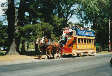
Photograph - Colour Photograph/s, William. F. Scott, 5/11/1992 12:00:00 AM
Yields information about the appearance and the use of Horse Tram No. 1 by the BTPS/BTM in Wendouree Parade.Colour photograph of horse tram No. 1 in Wendouree Parade on its launch day, 7.11.1992, photograph by William F Scott, printed on Fujicolor crystal archive paper. Photo used in Ballarat Tramway Museum book - "Ballarat's Heritage Tramway" On rear in ink "5" Ballarat Australia / Return to W.F.Scott / PO Box 2550 Cheltenham Vic 3192 Australia / Ballarat Tramway Museum restored horse car no. 1 / first day out after restoration. William F. Scott photo" and in bottom right hand corner "28A/1(7.11.1992).trams, tramways, wendouree parade, horse tram, tram 1 -
 Otway Districts Historical Society
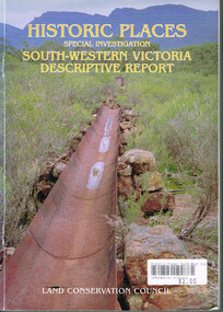
Book, Land Conservation Council, Historic places: Special investigation: South-Western Victoria: Descriptive report, January 1996
The south-west of Victoria, possessing a rich heritage of the signs of past human activity, is fertile ground for an investigation of historic places on public land. This report includes an initial inventory of almost 2000 places. The report outlines the history and the related heritage of the area, describes in some detail its biophysical attributes and introduces the natural resources and present land use. This information provides a context for understanding the origins of the historical features that are observes today.Historic places: Special investigation: South-Western Victoria: Descriptive report. Land Conservation Council. Land Conservation Council; Melbourne (Vic); January 1966. viii, 180 p.; illus.; maps. Soft cover. ISBN 0 7241 9288 3Maps in plastic sleeve.land conservation council; conservation; south-western victoria; historic places; -
 Colac RSL Sub Branch
Decorative object - Baulch Brothers. Their Service - Our Heritage. Photo/Badge Collection, Baulch Family, 2008
Item donated to Colac RSL by the Baulch Family February 2008. Constructed of Otway Forest Blackwood. Made by Frank Nemec of Eden N.S.W High SignificanceBlackwood Timber Frame. Blue material cloth background, with photos and military badges. Banner - Blue material with gold writingPhoto Frame:- Upper Left. Private Frank Baulch. VX72238 + small Rising Sun Badge. Born 15/11/1911 at Glen Aire, Vic. Enlisted 15/2/1942 in Caulfield, Vic. Discharged 3/12/1945. 2nd/2nd Pioneer Battalion. Lower Left. Corporal Horace Baulch. VX869036 + Large Rising Sun Badge. Born 29/4/1942 at Colac, Vic. Enlisted 29/4/1942 at Seymour, Vic. Discharged 13/3/1946. H.Q. AMF School of Mechanization. Centre. Lance Corporal Stanley Baulch VX72233. Born 8/12/1914 at Gellibrand, Vic. Enlisted 19/1/1942 in Caulfield, Vic. Discharged 5/12/1945. 2nd/2nd Pioneer Battalion. Private Jack Baulch VX72232. Born 18/5/1917 at Colac, Vic. Enlisted 15/1/1942 in Colac, Vic. Discharged 29/1/1946. ? Battalion Lower Centre. Female Relatives Badges and Information sheet. Badges:- Sarah, Alice, Iris and Elizabeth Baulch. Photo Sarah and Fred Baulch. Upper Right. Alexander Baulch VX56771 + small Rising Sun Badge. Born 21/2/1919 at Collingwood, Vic. Enlisted 28/5/1942 at Royal Park, Vic. Discharged 20/11/1945. ? Batt. Lower Right. Norman Baulch. VX86902 + large Rising Sun Badge. Enlisted 28/5/1942 at Royal Park, Vic. Born 5/12/1921 at Colac, Vic. Enlisted 29/7/1942 in Seymour, Vic. Discharged 28/2/1945. ?Batt. -
 Bendigo Historical Society Inc.
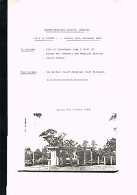
Document - GERMAN HERITAGE SOCIETY COLLECTION: TATURA DISTRICT 1939-1947, Sunday 14th November 1993
Compiled reference articles on the Tatura District, 1939-1947. Information from War Museum Archives, Canberra. File 780/1 (2 pages). Tatura and the Shire of Rodney, by W H Bossence. Walls of Wire, Tatura Rushworth Murchison by Joyce Hammond. The Story of the Beilharz Family by Dr. Paul Sauer. Contains a map, with Internment Camps, of the Shire of Rodney, Prisoners of War in Australia During World War 2, Special Requirements for Internees : Accommodation. Chap. 1, Prisoner of War and Internment Camps at Tatura, Vic., Plan of the Camp. Has a pale yellow front cover and a pale blue back cover.document, memo, german heritage society, german heritage society collection - visit to tatura, german heritage society bendigo, german war cemetry, war museum archives canberra, tatura and the shire of rodney, walls of wire tatura rushworth murchison, the story of the beilharz family, ian walder, geoff pedersen, kurt beilharz -
 Bendigo Historical Society Inc.
Document - BERT GRAHAM COLLECTION: BENDIGO EAST PROGRESS ASSOCIATION, 3/11/1989 - 22/2/1994
Documents, Bert Graham Collection, Bendigo East Progress Association, correspondence from Sandhurst Trustees, Vic Roads, Bendigo City Council, Corporate Affairs Victoria, Michael John, M.P. John Brumby, M.P.- Central Goldfields- World Heritage Recognition, in town of Maldon.bendigo, clubs, bendigo east progress association -
 Bendigo Historical Society Inc.
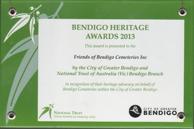
Award - BENDIGO HERITAGE AWARDS 2013 PRESENTED TO THE FRIENDS OF THE BENDIGO CEMETRIES INC
... and National Trust of Australia (Vic) Bendigo Branch bendigo Heritage ...bendigo Heritage Awards 2013 presented to the Friends of the Bendigo Cemetries Inc, by the City of Greater Bendigo and the National Trust of Australia (Vic) Bendigo Branch; in recognition of their advocacy on behalf of Bendigo Cemetries with the City of Greater BendigoPrimaryClassView ItemType AccessionPrefix AccessionYear AccessionNumber AccessionSeries AccessionParts Accession_Full_ID ItemName txtDescription txtMakersMarks LocationStatus Location AuthorizedBy LocationDate UsualLocation chkAesthetic chkHistoric chkScientific chkSocial chkCondition chkInterpretive chkProvenance chkRarity chkRepresentativeness cbxSignificanceRating txtStatementOfSignificance ItemDates txtEarliestYear txtLatestYear Importance txtHistoricalDetails txtHistoryText1 txtMaterials SizeMass txtDimensions txtBibliographReferences PrimaryClass SecondaryClass TertiaryClass ResearchBy ResearchYesNo txtResearchText1 txtResearchText2 SourceName Method ReceiptNum AmountPaid ConditionOnReceipt LegalTitleYesNo TitleDetails DateReceived CopyrightYesNo CopyrightDetails ReceivedBy Correspondence ReturnedYesNo PhotoNum NegativeNum OtherNum FileNum txtAdminText1 txtAdminText2 Award 2023 8007 30 2023.8007.30 BENDIGO HERITAGE AWARDS 2013 FRIENDS OF THE BRNSIGI CEMETRIES INC bendigo Heritage Awards 2013 presented to the Friends of the Bendigo Cemetries Inc, by the City of Greater Bendigo and the National Trust of Australia (Vic) Bendigp Branch; in recognition of their advocacy on behalf of Bendigo Cemetries with the City of Greater Bendigo Stored Box 859 joh hil 30/05/2023 Box 859 0 0 0 0 0 0 0 0 0 0 FRIENDS OF THE BENDIGO CEMETERIES Unknown $0.00 Excellent No No joh hil 0 Cirty of Greater Bendigo and National Trust of Australia (Vic) Bendigo Branch -
 Kew Historical Society Inc
Plan - Subdivision Plan, H C Crouch, Old Golf Links Estate, 1930s
The land in North Kew between the Outer Circle Railway and the River Yarra was released in sections. This release included 80 lots. Most of this area was released during the Depression years in the early 1930s.Subdivision plans are historically important documents used as evidence of the growth of suburbs in Australia. They frequently provide information about when the land was sold on which a built structure was subsequently constructed as well as evidence relating to surveyors and real estate and financial agents. The numerous subdivision plans in the Kew Historical Society's collection represent working documents, ranging from the initial sketches made in planning a subdivision to printed plans on which auctioneers or agents listed the prices for which individual lots were sold. In a number of cases, the reverse of a subdivision plan in the collection includes a photograph of a house that was also for sale by the agent. These photographs provide significant heritage information relating house design and decoration, fencing and household gardens.One part of a massive subdivision of the Old Golf Links Estate in North Kew of 80 allotments bordering Sutherland Avenue, Ramsay Avenue, Belford Road, Beresford Street and Coleman Avenue. Inset on the plan at the top left, the route of the Outer Circle Railway is clearly marked. The Kew Golf Links is identified in its current location. The land on which Greenacres Golf Club was to be constructed is at this time marked as ‘Recreation Ground’. The ‘new bridge’ over the Yarra at Burke Road is also marked on the inset map. The Plan identifies the surveyor (sic) H.C. Crouch BCE MVIS, 443 Little Collins St., Melbourne. The date of the subdivision auction sale in identified as Saturday September 25th at three o'clock.Annotations: "E" top left. "Golf Links" top right. Lots 73-76 ticked and listed as "6" poundssubdivisions -- kew (vic.), old golf links estate -
 Kew Historical Society Inc
Photograph - 29 Uvadale Grove, Kew, 1920
The numerous subdivision plans in the Kew Historical Society's collection represent working documents, ranging from the initial sketches made in planning a subdivision to printed plans on which auctioneers or agents listed the prices for which individual lots were sold. In a number of cases, the reverse of a subdivision plan in the collection includes a photograph of a house that was also for sale by the agent. Subdivision plans are historically important documents used as evidence of the growth of suburbs in Australia. They frequently provide information about when the land was sold on which a built structure was subsequently constructed as well as evidence relating to surveyors and real estate and financial agents. These photographs provide significant heritage information relating house design and decoration, fencing and household gardens.When 29 Uvadale Grove, Kew was offered for sale it was described as: ‘Kew. Fine locality, 3 minutes Cotham Road. Splendidly built 6 roomed Brick Villa. Rooms 17 x 14, 16 x 13, &c. Beautifully fitted throughout. Land 70 x 134 to ROW.’ The price was advertised as being £1,400. The house exhibits key features of Federation architecture such as the gabled roof with a facing of half-timber and stucco. The veranda has a curved corrugated iron roof supported by timber pillars and fretwork. The slate roof with terra cotta ridging and finials marks a transition to the more common use of Marseilles tiles in Federation architecture.subdivisions - kew (vic.), 29 uvadale grove - kew (vic.) -
 Kew Historical Society Inc
Photograph - Victorian Villa, High Street, c.1922
Subdivision plans are historically important documents used as evidence of the growth of suburbs in Australia. They frequently provide information about when the land was sold on which a built structure was subsequently constructed as well as evidence relating to surveyors and real estate and financial agents. The numerous subdivision plans in the Kew Historical Society's collection represent working documents, ranging from the initial sketches made in planning a subdivision to printed plans on which auctioneers or agents listed the prices for which individual lots were sold. In a number of cases, the reverse of a subdivision plan in the collection includes a photograph of a house that was also for sale by the agent. These photographs provide significant heritage information relating house design and decoration, fencing and household gardens.An old inscription on this photograph identifies it as ‘an elegant timber villa in High Street. It occupied part of Lot 91, bought by Edward Glyn in the land sale of 16th October 1851, and run as a flower farm’. The subdivision called the ‘Flower Farm Estate’ in East Kew occurred in 1922. [The subdivision plan is on the reverse of this photo.] The Estate included 61 lots on either side of Boorool Road between High Street and Harp Road. In the MMBW Detail Plan 2017 of 1926, a number of these new villas had already been built. Matching houses with MMBW maps can always be a challenge, however if this house was near the corner of Boorool Road and High Street, it seems to fit the profile of a house called ‘Maxton’ (demolished).Photographer's name on photograph, lower right, and stamp on mount lower right: "A. Aberline, Glenferrie".houses - maxton - high street - kew (vic.), violet farm estate, subdivisions - kew (vic.) -
 Kew Historical Society Inc
Plan - Subdivision Plan, Balwyn Theatre and Shop Sites, circa 1927-28, c.1927-28
The Kew Historical Society's map collection includes a substantial number of real estate subdivision plans, mainly of Kew but also of surrounding suburbs in Melbourne. Most of the subdivision plans date from the 1920s and 1930s when the districts old homes and local farmland were being split up to accommodate residential growth in the postwar period. These early plans were assembled by a local firm, Jas R Mather & McMillan, which had an office in Cotham Road. Many of the plans, and sometimes photos, were annotated by the agents. The ‘new’ Balwyn Picture Theatre was built and owned by Balwyn Theatres Pty Ltd in ca. 1928. By 1930, this first Balwyn Theatre was destroyed by fire after a break-in. Following the fire, a new cinema was constructed. This plan for a Cinema and eleven shops presumably dates from 1927/28 when the Company announced that this location in Whitehorse Road ‘was the most central and best suited [area] for their Theatre and shops’.Subdivision plans are historically important documents used as evidence for the growth of suburbs in Australia. They frequently provide information about when the land was sold as well as evidence relating to surveyors and real estate and financial agents. The numerous subdivision plans in the Kew Historical Society's collection represent working documents, ranging from the initial sketches made in planning a subdivision to printed plans on which auctioneers or agents listed the prices for which individual lots were sold. In a number of cases, the reverse of a subdivision plan in the collection includes a photograph of a house that was also for sale by the agent. These photographs provide significant heritage information relating house design and decoration, fencing and household gardens.The photograph may also be aesthetically significant depending on the importance of the photographic atelier.Subdivision plan showing the Balwyn Theatre and its adjoining shop sites in Whitehorse Road Balwyn. The 11 shop sites were noted for their depth (133 ft - 145 ft. [Map.0041]balwyn theatre -- balwyn (vic.), subdivisions -- balwyn (vic), subdivision plans -
 Kew Historical Society Inc
Plaque, Kew City Hall : Opened by The Hon H.E. Bolte M.L.A. Premier of Victoria 23rd April 1960 : Cr H.H. Ferguson J.P. Mayor, 1960
The Municipality of Kew was proclaimed on 19 December 1860, then upgraded to a Borough (1863), a Town (1910) and finally a City (1921). From 1865, its offices were based in the former Athenaeum Hall in Walpole Street, which, although extended in 1883, inevitably became inadequate. Plans for a new purpose-built Town Hall were first mooted in the late 1880s, but fell prey to six subsequent decades of debate. During that time, many sites were considered and rejected, and several schemes prepared. Finally, in 1945, it was resolved to build a new civic centre as a war memorial. The council acquired Southesk, a mansion on the south-west corner of Cotham Road and Charles Street – first mooted as a possible Town Hall site two decades earlier – and plans for a civic precinct were drawn up by John Scarborough. The project stalled until 1957, when a Town Hall Committee was formed and a new architect appointed: Harold Bartlett of Leith & Bartlett. He also proposed an entire civic precinct, of which a large public hall would constitute Stage One. Designed to accommodate almost any public or official function, the space had had a small stage at one end for intimate theatrical productions, a larger stage at the other (with operable sunken orchestra pit) for musical performances, plus the most up-to-date equipment for live TV transmission. The building, befitting its original intent as a war memorial, was also to include a sculpted monument, for which a separate design competition was held. First prize went to George H Allen (1900-1972), long-time head of the Sculpture Department at RMIT and a former war artist himself (the only one, in fact, to have worked in the medium of sculpture). At the time of the Kew project, Allen was best known for his Cenotaph at the Shrine of Remembrance (1955) and a controversial abstract sculpture at Hume House in William Street (1957). Tenders for the new hall were called and the contract (worth £104,986) was awarded to H F Yuncken. The foundation stone was laid by the Mayor, Cr F C O'Brien, on 1 June 1959. Completion (initially scheduled for October) was delayed by the unavailability of certain materials; it was barely finished in time for the official opening (by Premier Henry Bolte) on 23 April 1960. The war memorial was unveiled two days later (Anzac Day) by Bolte's deputy, the Hon A G Rylah. Fittingly, that year also marked Kew's municipal centenary, and many celebratory events were held in and around the new civic centre in December, including a special council meeting (attended by the Prime Minister), a tree planting ceremony and a youth ball. Source: Survey of Built Heritage in Victoria: Stage Two (Built Heritage Pty Ltd., 2010)Plaque commemorating the opening of a new town hall in KewMetal plaque recording the official opening of the Kew City Hall, 23rd April 1960. This plaque was given to the Kew Historical Society in 1991 by the former City of Kew.Kew City Hall / Opened by / The Hon. H.E. Bolte M.L.A. / Premier of Victoria / 23rd April 1960 / Cr. H.G. Ferguson J.P. - Mayor.kew city hall, foundation stones - kew (vic), sir henry bolte, local government -- kew (vic.) -
 Kew Historical Society Inc
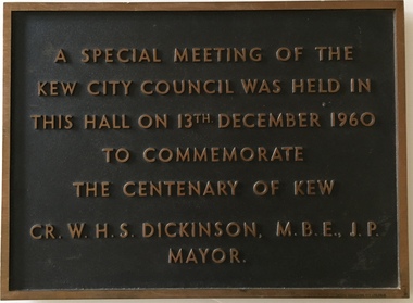
Plaque, A Special Meeting of the Kew City Council Was Held in This Hall on 13th December 1960 to Commemorate the Centenary of Kew : Cr. W.H.S. Dickinson M.B.E., J.P. Mayor, 1960
The Municipality of Kew was proclaimed on 19 December 1860, then upgraded to a Borough (1863), a Town (1910) and finally a City (1921). From 1865, its offices were based in the former Athenaeum Hall in Walpole Street, which, although extended in 1883, inevitably became inadequate. Plans for a new purpose-built Town Hall were first mooted in the late 1880s, but fell prey to six subsequent decades of debate. During that time, many sites were considered and rejected, and several schemes prepared. Finally, in 1945, it was resolved to build a new civic centre as a war memorial. The council acquired Southesk, a mansion on the south-west corner of Cotham Road and Charles Street – first mooted as a possible Town Hall site two decades earlier – and plans for a civic precinct were drawn up by John Scarborough. The project stalled until 1957, when a Town Hall Committee was formed and a new architect appointed: Harold Bartlett of Leith & Bartlett. He also proposed an entire civic precinct, of which a large public hall would constitute Stage One. Designed to accommodate almost any public or official function, the space had had a small stage at one end for intimate theatrical productions, a larger stage at the other (with operable sunken orchestra pit) for musical performances, plus the most up-to-date equipment for live TV transmission. The building, befitting its original intent as a war memorial, was also to include a sculpted monument, for which a separate design competition was held. First prize went to George H Allen (1900-1972), long-time head of the Sculpture Department at RMIT and a former war artist himself (the only one, in fact, to have worked in the medium of sculpture). At the time of the Kew project, Allen was best known for his Cenotaph at the Shrine of Remembrance (1955) and a controversial abstract sculpture at Hume House in William Street (1957). Tenders for the new hall were called and the contract (worth £104,986) was awarded to H F Yuncken. The foundation stone was laid by the Mayor, Cr F C O'Brien, on 1 June 1959. Completion (initially scheduled for October) was delayed by the unavailability of certain materials; it was barely finished in time for the official opening (by Premier Henry Bolte) on 23 April 1960. The war memorial was unveiled two days later (Anzac Day) by Bolte's deputy, the Hon A G Rylah. Fittingly, that year also marked Kew's municipal centenary, and many celebratory events were held in and around the new civic centre in December, including a special council meeting (attended by the Prime Minister), a tree planting ceremony and a youth ball. Source: Survey of Built Heritage in Victoria: Stage Two (Built Heritage Pty Ltd., 2010)Historically significant commemorative plaqueMetal plaque relating to special Council meeting to mark centenary of Kew, 13th December 1960. This plaque was given to the Kew Historical Society in 1991 by the former City of Kew.A Special Meeting Of The / Kew City Council Was Held In / This Hall On 13th December 1960 / To Commemorate / The Centenary of Kew / Cr. W.H.S. Dickinson, M.B.E., J.P., / Mayorkew city hall, foundation stones - kew (vic), cr. w.h.s. dickinson, local government -- kew (vic.) -
 Kew Historical Society Inc
Plan - Subdivision Plan, J R Mathers & McMillan, Heart of Richmond Estate : Richmond, 1928
"In 1928 the land on the east side of Johnson Street was subdivided in 60 lots for the ‘Heart of Richmond Estate’. The houses in the subdivision, along the east side of Johnson Street, and in the newly created Hollick, Cole and Kennedy streets were constructed from 1928 to 1937." (Source: City of Yarra Heritage Gaps Review One 2013)Portion of subdivision plan pasted on to cardboard. Area includes Johnson Street, Victoria Street, Kennedy Street, Cole Street, Hollick Street, Bennett StreetTitle Certificate Vol.2381, Folio 476130 Phillips, Fox & Masel, 440 Little Collins Street, Melbourne (Local estate agent: Jas. R. Mathers & McMIllan, 136 Cotham Road, Kew)subdivision plans - richmond (vic.), heart of richmond estate -
 Kew Historical Society Inc
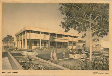
Drawing, AK Lines, Macfarlane & Marshall, Kew Civic Centre, c.1970
The Kew Civic Centre (A K Lines, MacFarlane & Marshall, 1972) was built next to the Kew Civic Hall (A C Leith & Bartlett, 1960) on the site of the former mansion Ordsall (later renamed South Esk). Whereas the entrance to the Civic Hall was positioned off Civic Drive, the main entrance to the Civic Centre faced Cotham Road, as shown in the undated perspective drawing of the proposed building. The Civic Hall was used for public functions and performances, while the Civic Centre was used for civic offices. It also contained the Council Chamber. The building opened in 1972, following the relocation of the councillors and council officers from the former Town Hall in Walpole Street (now a Woolworth's supermarket). Following the amalgamation of the former City of Kew into the City of Boroondara in 1994, the Civic Centre was sold to Trinity Grammar School. The exterior of the Centre has been modified by Trinity Grammar.A report for Heritage Victoria (date) describes how two architectural firms dominated the designs for new civic buildings in Victoria during the post war period. The report claims that: "An interesting sub-theme in the erection of post-war municipal offices in Victoria is that a considerable proportion were designed by the same three or four Melbourne-based architectural firms, who established themselves as the leading specialists in this type of work. The two most prolific firms in this regard were A K Lines, MacFarlane & Marshall, and A C Leith & Bartlett; both, in fact, had made names for themselves as designers of local government offices prior to the Second World War. Lines' office, for example had designed the Eltham Shire Offices in 1941, while Leith's firm had been responsible for the celebrated Heidelberg Town Hall in 1937). Both practices parleyed this early experience into a lucrative post-war career, designing numerous municipals offices well into the 1970s." (Survey of Post-War Built Heritage in Victoria, Built Heritage Pty Ltd, 2010.) The perspective drawing importantly captures the original design and function of the exterior of the building and its public entrance.Hand-coloured perspective sketch of the new Kew Civic Centre, completed in 1972 to designs by A K Lines, MacFarlane & Marshall; and located on the corner of Charles Street and Cotham Road, Kew. The sketch represents the front elevation of the building and its relation to the preexisting Kew Civic Hall at right. The three storey building features strong vertical concrete buttresses that extend across the three levels. KEW CIVIC CENTRE / A K LINES, MACFARLANE & MARSHALLkew civic centre, a.k. lines, macfarlane & marshall, architectural drawings, civic buildings -- kew (vic.), town hall -- kew (vic) -
 Kew Historical Society Inc
Photograph, Outer Circle Railway Bridge over River Yarra, c.1900
This photograph forms part of the Eric Sibly collection of images and information relating to the Outer Circle Railway which he donated to the Kew Historical Society in 1974. Heritage Victoria Citation (Abridged) "The Chandler Highway Bridge, a 137 metre wrought iron lattice-truss girder bridge with four spans supported on red brick piers with moulded bluestone cappings. The bridge has a cantilevered walkway along the west side. ...The Chandler Highway Bridge crosses the Yarra River and connects Alphington and Kew. It was completed in November 1890 as part of the Outer Circle Railway Line.Black & white photograph of the railway viaduct over Yarra River looking south towards Kew.Reverse: "Pre 1930. Outer Circle Railway Bridge over River Yarra (now Chandler Highway) - note bridge over line on Kew side for Asylum Farm". KH - 56. Kew Historical Society.chandler highway, railway bridges - kew (vic), sir john monash, outer circle railway, river yarra - kew (vic)