Showing 349 items matching "homestead road"
-
 Mt Dandenong & District Historical Society Inc.
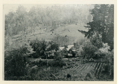
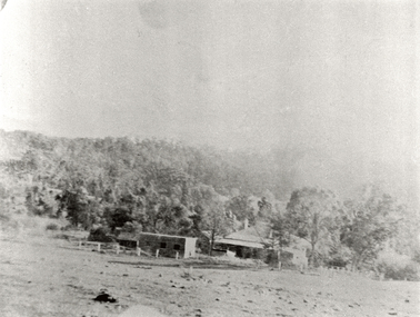
Photograph, Home Of Francis Matthew Child, c1910
The homestead of Francis Matthew Child taken from the forest area downstream of Child Bros. Sawmill.Black and white photograph showing the homestead of Francis Matthew Child.This photograph has a detailed inscription on the back handwritten by John Lundy-Clarke.Francis Matthews home on Crown Allotment “E” taken from the forest edge of Harry Child miners lease on which he had his mill. Mill was upstream to the left. The trees in the background were on Hand’s selection “F” and beyond them was the summit of Mt Kalorama.homestead, francis matthew child, sawmill, child's sawmill -
 Mt Dandenong & District Historical Society Inc.
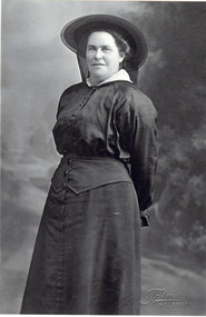
Photograph, Mrs Ellis Jeeves, nee Eliza Hand
Eliza Hand married Ellis Jeeves in 1885. They had 12 children, with 8 surviving to adulthood (5 boys and 3 girls). Eliza was one of the daughters of Thomas and Eliza Hand of Mountain Grange Homestead. Eliza and Ellis extended their home in the valley 'Kalorama' to become a Guest House. In 1908 they purchased 'Mountjoy Guest House' from the Paynter family and ran a very successful guest house and coach business. Following the death of Ellis Jeeves in a buggy accident in 1921, Eliza ran the guest house and her son, Hubert, the coaching business. Black and white studio portrait of middle aged woman dressed in a black outfit and wearing a black hat. eliza hand, eliza jeeves, ellis jeeves, mountjoy -
 Mt Dandenong & District Historical Society Inc.
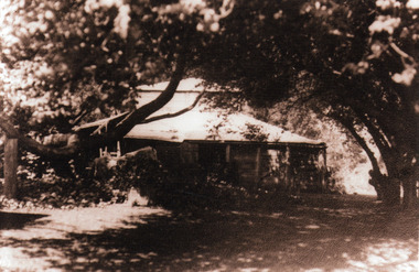
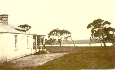
Photograph, 'Mountain Grange', Homestead of Thomas Hand and Family
View through trees of Mountain Grange, home of the Hand family. Now the site of Kalorama Memorial Reserve and Karwarra Gardens.Sepia photograph showing a wooden building in a treed setting.thomas hand, mountain grange, kalorama memorial reserve, karwarra gardens -
 Mt Dandenong & District Historical Society Inc.
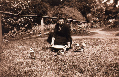
Photograph, Feeding the Kookaburras at Mountain Grange
Unnamed woman, most likely one of the Hand Family, feeding four kookaburras in the garden at Mountain Grange Homestead..Sepia photograph of women crouching to hand feed four plump kookaburras in a garden with a railing fence behind.mountain grange -
 Mt Dandenong & District Historical Society Inc.
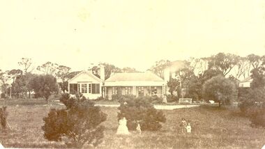
Photograph, Mountain Grange and Great Barn Kalorama c1890, c1890
Mountain Grange homestead with the great barn. Left are remains of tree clearance. Fruit tress at right angle to the house. Other cultivation evident. This is the earliest of the 3 views in the collection.mountain grange, kalorama -
 Mt Dandenong & District Historical Society Inc.
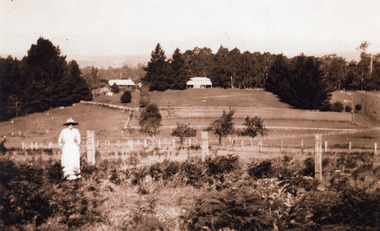
Photograph, Mountain Grange and Great Barn Kalorama c1910, c1910
View of Mountain Grange Homestead with Great Barn. Tree stumps still visible. Fruit tress still present. Less cultivation near house. Fences more uniform and indication of a road.Woman in dress and bracken in foreground.kalorama, mountain grange -
 Mt Dandenong & District Historical Society Inc.
Photograph, The Settlement of Harmony Vale 1913, 1913
View of the settlement of Harmony Vale taken in 1913 with the guest house Kia Ora, built by George Barber in 1909, in the foreground. This photograph has a detailed inscription on the back handwritten by John Lundy-Clarke.The settlement of Harmony Vale 1913. The large home in foreground is the Guest House “Kia Ora” owned by George Barber on Lot 25 of the Village Settlement. The house above it to the left was Richardson’s house. The home of Jeanie who had left it when the picture was taken.The buildings furthest to the right of “Kia Ora” were the homestead of Isaac Jeeves of 1863 – 1871 the building furthest right with the black opening in it was the house with the tree fern floor. The flat ground above and left of Isaac’s pointed roof barn is where the creek changed its course in the 1934 flood and destroyed £4000 worth of the Rowse family’s tulip bulbs. Above the flat is Francis Matthew Child’s homestead, in the creek to the right of which can be seen the horizontal structure of the swing bridge to the sawmill of the Childs Bros which cannot be seen but in the forest to the right of the mill (bridge) can be seen a number of logs in the mill yard. The two cleared strips immediately behind Childs home were the Richardson’s original holdings and the house in the gully at the far side of the great clearing is that of the guest house “Glenrivers” belonging to W Lucas and his wife Catherine nee Child. The Richardson homestead “Harmony Vale” is behind the forest trees in the right centre. The picture gives a full view of how the settlement was cut into the centre of the great forest. george barber, kia ora, harmony vale, barber, jeanie richardson, richardson, child, matthew child, kia-ora guest house, guest house, glenrivers -
 Mt Dandenong & District Historical Society Inc.
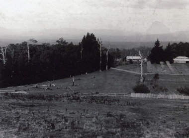
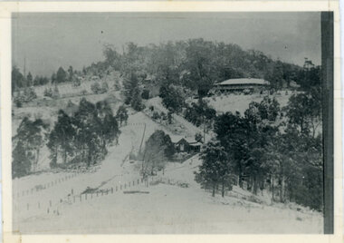
Photograph, A View Over Mountain Grange 1921, 1921
A view of Mountain Grange Homestead built by Thomas Hand with buildings and ground covered in snow. The photograph has historical information on the back handwritten by John Lundy-Clarke in 1976.1921 A view over “Mountain Grange” from the side of Mt Kalorama above where Grange Road is now. On the left of the homestead is the avenue of pine trees under which the annual Sunday School picnic was held. On the right is the giant pine that still stands (1976) and the great barn. The separate kitchen of the homestead can be clearly seen. mountain grange, snow, john lundy-clarke, thomas hand -
 Mt Dandenong & District Historical Society Inc.
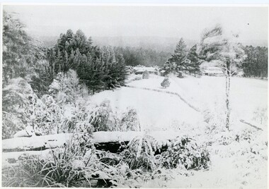
Photograph, Kalorama Gap Under Snow 1921, 1921
View of Kalorama Gap under snow taken in 1921. Mountjoy Guest House is at top right and Beulah Tea Rooms is in the centre. This photograph has a detailed inscription on the back handwritten by John Lundy-Clarke in 1974.Kalorama Gap under snow 1921 The leafless elm trees are low in the centre and the dual nature of the nearer one can be clearly seen, two small suckers of the older farther tree being twisted together in 1898 by Fred Jeeves. The older tree was planted 1880. Mrs Hands shop can be clearly seen, which was the Mount Dandenong North Post Office. The old Main Road runs up the centre of the picture and turns to the right and disappears behind “Mountjoy” the big guest house built by Paynters in 1905 and sold to Ellis Jeeves 1908, whose family ran it till 1943. At the bend of the road behind the big pine tree and the dark blackwood can be seen faintly the gable of Price’s house that contained the first shop on the mount. Above it is H Walker’s cottage on Ridge Road that still exists, his homestead is on the left of the picture on the same level. Below this house and to the left can be seen Ted Prices hay and corn store. The present estate agency lies between these two buildings, on the road which had recently been built. This can be seen winding from the lower left corner of picture to the left of the elms. The CRB had recently fenced the road and this is clearly seen as it circles behind trees in the left centre. Barber’s Road crosses CRB Road to the left of the dray under the leafless elm and the Coach Road dives down to the right just behind the pair of blackwoods to right of the elms. The picture was taken from just above the boundary of Isaac Jeeves’s selection Crown Allotment “C” (Jeeves Saddle) which stretched across the Gap to the other side of Mrs Hand’s shop, monopolising the gap from 1871 to 1879. Price’s house remains partly as the small house – “Mirra Laken”. kalorama gap, fiveways, post office, mountjoy, guest house, snow -
 Mt Dandenong & District Historical Society Inc.
Photograph, Post Office and 'Mountjoy', Mt. Dandenong North, 1913
Rose Series post card #182Copy of Rose Series postcard #182 showing Kalorama Gap in 1913. Haystacks in foreground with Mountjoy Guest House and Beulah Tea Rooms/Mt Dandenong North Post Office in centre. This photograph has a detailed inscription on the back handwritten by John Lundy-Clarke in 1974.Kalorama Gap in 1913 The elm trees are in the centre of the picture. One of these is really two as two suckers of the further tree were twisted together by Fred Jeeves in 1898 and grew as one tree. The other was planted in 1880. The shop is the shop of Mrs Eliza Hand and daughter Florence. The closed in far end of the verandah was the Mount Dandenong North Post Office. The large house is “Mountjoy” owned and run by the Jeeves Family from 1908 till 1943. It was built in 1905 by the Paynters who sold to Ellis Jeeves in 1908.He moved his line of coaches from “Kalorama” his old homestead and housed the horses in a line of stables behind “Mountjoy”. Price’s house, which contained their shop, the first one on the mountain, opened 1906, can be seen faintly behind the pine tree opposite the bend in the road, which was the main road then and now is Ridge Road. The Price’s house just shows in two tiny pieces, one on each side of the pine tree half way up. The house to the right of and high up the pine tree is Walker’s cottage which exists today opposite Jack Kidd’s home at the far edge of Lt 2 Village Settlement and was between Main Road and Barbers Road which runs down the left behind the elms. Walker’s homestead can be seen near left edge of picture 2/3 way up. The roof of the Methodist Church shows among trees left of picture. This, like Mrs Hand’s shop was built on portions separated from Isaac Jeeves’ Selection “C” known as Jeeves Saddle. kalorama gap, five ways, mountjoy, john lundy-clarke, beulah tea rooms, post office, fred jeeves, paynter, jeeves, frederick jeeves, price, walker, jack kidd -
 Mt Dandenong & District Historical Society Inc.
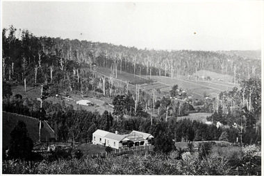
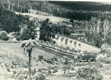
Photograph, The Valley of the Harmony Vale Settlement c1910, 1973
Scene looking across the valley of Harmony Vale from Barbers Road. c1910. Photograph copied by John Lundy-Clarke in 1973. This photograph has a detailed inscription on the back handwritten by John Lundy-Clarke in 1974.The valley of the Harmony Vale settlement on the Olinda Creek from Barbers Road. "Shiloah" on far left centre. John William Richardson's home among trees left of centre. Homestead Harmony Vale above log yard (see below) and among orchard trees. Child Bros sawmill and log yard with logs among trees above flat cultivation right of centre. Bert Childs home beyond "Harmony Vale". Lucas' "Glenrivers" is in gully above main clearing centre top left. Frank Childs home among trees centre of picture. Taken about 1910 by Rose Series. Copied 1974 JLC.kalorama, harmony vale, olinda creek, barbers road, shiloah, sawmill, child, bert child, glenrivers -
 Southern Sherbrooke Historical Society Inc.
Information folder - Lysterfield
Information folder containing items pertaining to the history of Lysterfield. Contents: -Articles copied from Knox HS newsletter, inc. Lysterfield, Lysterfield Road, -typescript, "Early settlement of the district later known as Lysterfield", 5 pages -typesccript, "William Lyster and the Lysterfield Valley", 2 pages -map, part of parish map of Scoresby, showing holdings in Lysterfield -illustrations, "A Victorian Model Farm: Nareewarran Grange" -illustration, The Homestead (Nareewarran Grange), 2 copies -copy, 'The Golden Age Of Australian Opera', Chapter 7, an account of William Lyster at Lysterfieldwilliam lyster, lysterfield, nareewarran grange -
 Kew Historical Society Inc
Album, Eva Grant, Historic Buildings in Victoria & New South Wales, 1919-c.1962
One of three scrapbooks created by Eva Grant, a past member of the Kew Historical Society which were donated by her niece, Julie Thomson, in 2013. The scrapbook includes photographs and descriptions of the following sites. (Many of these are now demolished and so the photographs and descriptions may be rare records of a site.) Sites include: Abbotsford (Vic) - Abbotsford Convent, Mayfield (c.1962), prefabricated house - Church street Armadale (Vic) - church (c.1959) - Thomson & Wattletree Roads Arthur’s Seat (Vic) - McCrae homestead Ballarat (Vic) - Memorial plaque on site of Bentley’s Hotel, Memorial on site of Eureka Stockade, Early municipal buildings - East Ballarat, Adam Lindsay Gordon’s cottage - Botanical Gardens, View from Sovereign Hill, Shell house Broken Hill (NSW) - panorama (1963), Flying Doctor’s base (?1963) Eltham (Vic) - Hassell’s outdoor art gallery Essendon (Vic) - Niddrie Homestead and stables (1963) Geelong (Vic) - first Bishopscourt Hawthorn (Vic) - Convent (1930), The Hawthorns, Keilor plains (Vic) - pioneer homes, pioneer cemetery Kew (Vic) - Roseneath (1951), Tarring - Ruyton, Turinville, house - Foley street (c.1960). Malvern (Vic) - church Mount Ridley (Vic) - Summerhill Melbourne (Vic) - Old Brewery - Custom’s House Lane (1960), Customs House, Scott’s Hotel (1962), Western market (c.1960) Phillip Island (Vic) - Grave Toorak (Vic) - Mandeville Hall, Merna (sic) - Arthur Streeton’s house, Toorak House Wentworth (NSW) - Harvey’s Hotel, Sturt Memorial, Sturt’s Tree, Wentworth Gaol Williamstown (Vic) - Williamstown Dairy Yan Yean (Vic) - Bear’s Castle (c.1947) Beveridge/Big Hill (Vic) - Kelly’s cottageImportant photograph record (and notes) about historic buildings in Victoria.38-page scrapbook with additional text created by Eva Grant, a past member of the Kew Historical Society. In addition to the 68 photographs, there are two postcards and a number of publications/handouts.collected by Eva on her trips to heritage sites in Victoria and New South Wales. The pages of the album can be viewed in the image carousel above. Most of the photographs of heritage buildings were taken in the early 1960s.See imagesheritage sites - victoria - australia, eva grant, scrapbooks - 20th century -
 Sunbury Family History and Heritage Society Inc.
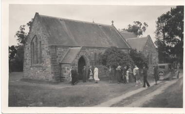
Photograph, c 1930s
... a site along Oaklands Road, adjacent to 'Woodlands' homestead... Oaklands Road, adjacent to 'Woodlands' homestead ...St. Mary's Anglican Church at Bulla originally occupied a site along Oaklands Road, adjacent to 'Woodlands' homestead. It was established in 1859. With there building of the Melbourne Airport at Tullamarine it was found that the church on its existing site was directly under the flight path of the aircraft so the building was demolished stone by stone and rebuilt in the Bulla township adjacent to the Alistair Clark Rose Garden. The original site has not been developed because some early graves are there.St. Mary's Church at Bulla is one of the earliest to be established in the Bulla district. Its mother church, St Pauls Church of England at the original Broadmeadows township was established in 1850 and it still stands and operates on its original site.A black and white photograph with a cream border of a stone church with the congregation members entering the church. A saloon car is parked near the church.st. mary's church of england, bulla., churches. -
 Brighton Historical Society
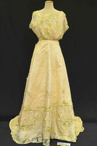
Clothing - Dress, Evening dress, c. 1909
This evening dress belonged to Clara Johnstone Miller (nee Bell, 1866-1910). Clara was the only daughter of Mr James Bell, a councillor of the Shire of Leigh (today a part of Golden Plains Shire) and owner of Woolbrook Homestead in Teesdale, near Geelong. In 1888, Clara married prominent businessman, racehorse owner, racing identity and pastoralist Septimus Miller (1854-1925). Septimus was the sixth of seven children born to Henry 'Money' Miller and Eliza Miller (nee Mattinson). 'Money' Miller was a well known financier and politician and reputedly one of Australia's wealthiest people in his time. In 1889, Clara and Septimus moved into the house 'Cantala' in Dandenong Road, Caulfield. They had one child, Gwendoline Stewart Miller, who died in 1902 at the age of thirteen of diabetes - a largely untreatable condition at the time (insulin would not be discovered until 1921). Clara died in 1910, aged only 44. Septimus subsequently married Helen (nee Henderson), with whom he had a son, Ronald (1915-1990). The Millers were buried in the Brighton General Cemetery in a large Gothic-style vault. Upon Clara's death, Septimus sent much of her clothing and Gwendoline's to her mother Mary Bell. Some of these items were passed down to two of Clara's nieces, Miss Mary Bell and Mrs Lois Lillies, who donated them to BHS around 1973.A yellow and lime green silk and net evening dress from c.1909. The bodice is constructed of a golden silk satin with an over bodice of a very soft gold net with soft gold and lime green embroidery decorated with flower and bow motif's. The neckline is bateau like in shape with the edge following the flowers of the lace design. The bodice is sleeveless with a loose detached cap that hangs down over the top of the arm with a lace covering. The under fabric of the bodice is shaped and lightly boned but the over lace is looser, nipping in at the waist where it joins the skirt. At the back, the bodice neckline scoops lower than the front with the lace overlay creating a v shape at the centre back. The bodice is secured with hooks and eyes and waist tapes. The skirt is flat fronted and floor length consisting of the same golden yellow silk with soft gold and lime green embroidered net over skirt. The lace net over skirt features larger motifs and greater embellishment towards the bottom of the skirt. The lace over lay also has an edge that follows the design of the lace rather than a straight edge. At the back the underskirt is flat and shaped but the over skirt is lightly gathered and loose hanging. The skirt finishes in a full skirt and a rounded, small train.woolbrook, septimus miller, cantala, henry 'money' miller, gwendoline miller, clara miller, 1900s fashion, caulfield, brighton general cemetery -
 Brighton Historical Society
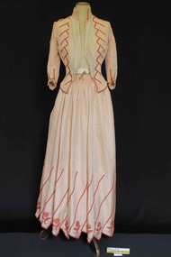
Clothing - Dress, Afternoon dress, c.1890
This afternoon dress belonged to Clara Johnstone Miller (nee Bell, 1866-1910). Clara was the only daughter of Mr James Bell, a councillor of the Shire of Leigh (today a part of Golden Plains Shire) and owner of Woolbrook Homestead in Teesdale, near Geelong. In 1888, Clara married prominent businessman, racehorse owner, racing identity and pastoralist Septimus Miller (1854-1925). Septimus was the sixth of seven children born to Henry 'Money' Miller and Eliza Miller (nee Mattinson). 'Money' Miller was a well known financier and politician and reputedly one of Australia's wealthiest people in his time. In 1889, Clara and Septimus moved into the house 'Cantala' in Dandenong Road, Caulfield. They had one child, Gwendoline Stewart Miller, who died in 1902 at the age of thirteen of diabetes - a largely untreatable condition at the time (insulin would not be discovered until 1921). Clara died in 1910, aged only 44. Septimus subsequently married Helen (nee Henderson), with whom he had a son, Ronald (1915-1990). The Millers were buried in the Brighton General Cemetery in a large Gothic-style vault. Upon Clara's death, Septimus sent much of her clothing and Gwendoline's to her mother Mary Bell. Some of these items were passed down to two of Clara's nieces, Miss Mary Bell and Mrs Lois Lillies, who donated them to BHS around 1973.A salmon (pale orange pink) corded silk afternoon dress with orange beaded embellishments, consisting of a bodice (.1) and skirt (.2) from c.1890. The bodice features a high standing collar with triple pleated bone silk chiffon trim along the top line, under the chin. This same chiffon is also secured in two pieces gathered and secured under the collar and and at the waist adding volume over the bust line and partially obscuring the jacket closing. The chiffon is secured at the side into the main fabric of the bodice by the beaded embellishment. The pink seed beads are sewn in lines of five beads one after the other creating a diagonal design that tapers from the shoulder to the waist. The bodice is boned around the front and back and secured down the centre font by nineteen hook and eyes and additional cotton tapes. Further beading details the bottom centre front and base line of the bodice. The shoulders have been repaired with replacement fabric to match, from our records it appears that the repair work was performed in circa 1974 but no record exists of the original shoulder design and if the repair was an exact copy of the original. The repaired shoulders feature a small frill around the shoulder yoke and top of the arm. The sleeve is fitted and three quarter finishing just below the elbow. The base of the sleeve is also trimmed with the pink bead design and bone three pleat chiffon trim. The back of the bodice features shaped panels contouring the jacket neatly in at the waist and then splitting and splaying out over the fullness of the skirt. The skirt appears to have been floor or ankle length held at the waist by a wide waistband. The skirt openings have been altered from the original currently featuring two openings secured by press studs. The skirt is gathered to the waistband at front and back creating fullness. The lower part of the skirt features the same pink bead embellishment and additional beaded flowers and diagonal point edge detail.clara miller, woolbrook, septimus miller, henry 'money' miller, gwendoline miller, cantala, 1890s fashion, caulfield, brighton general cemetery -
 Brighton Historical Society
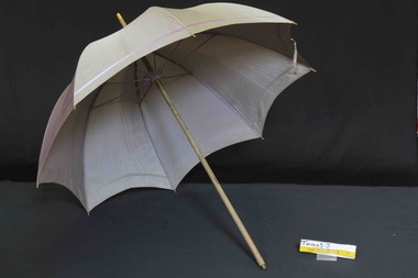
Accessory - Parasol, late 19th century
This parasol belonged to Clara Johnstone Miller (nee Bell, 1866-1910). Clara was the only daughter of Mr James Bell, a councillor of the Shire of Leigh (today a part of Golden Plains Shire) and owner of Woolbrook Homestead in Teesdale, near Geelong. In 1888, Clara married prominent businessman, racehorse owner, racing identity and pastoralist Septimus Miller (1854-1925). Septimus was the sixth of seven children born to Henry 'Money' Miller and Eliza Miller (nee Mattinson). 'Money' Miller was a well known financier and politician and reputedly one of Australia's wealthiest people in his time. In 1889, Clara and Septimus moved into the house 'Cantala' in Dandenong Road, Caulfield. They had one child, Gwendoline Stewart Miller, who died in 1902 at the age of thirteen of diabetes - a largely untreatable condition at the time (insulin would not be discovered until 1921). Clara died in 1910, aged only 44. Septimus subsequently married Helen (nee Henderson), with whom he had a son, Ronald (1915-1990). The Millers were buried in the Brighton General Cemetery in a large Gothic-style vault. Upon Clara's death, Septimus sent much of her clothing and Gwendoline's to her mother Mary Bell. Some of these items were passed down to two of Clara's nieces, Miss Mary Bell and Mrs Lois Lillies, who donated them to BHS around 1973.A grey silk parasol with mauve stripe decoration, wooden handle and brass fittings from the late 19th century. The handle appears to be missing a decorative finish from the end.Mrs. S. Miller, Cantala, Caulfield.clara miller, woolbrook, septimus miller, henry 'money' miller, gwendoline miller, cantala, caulfield, brighton general cemetery -
 Brighton Historical Society
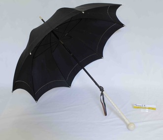
Accessory - Parasol, circa 1900
This parasol belonged to Clara Johnstone Miller (nee Bell, 1866-1910). Clara was the only daughter of Mr James Bell, a councillor of the Shire of Leigh (today a part of Golden Plains Shire) and owner of Woolbrook Homestead in Teesdale, near Geelong. In 1888, Clara married prominent businessman, racehorse owner, racing identity and pastoralist Septimus Miller (1854-1925). Septimus was the sixth of seven children born to Henry 'Money' Miller and Eliza Miller (nee Mattinson). 'Money' Miller was a well known financier and politician and reputedly one of Australia's wealthiest people in his time. In 1889, Clara and Septimus moved into the house 'Cantala' in Dandenong Road, Caulfield. They had one child, Gwendoline Stewart Miller, who died in 1902 at the age of thirteen of diabetes - a largely untreatable condition at the time (insulin would not be discovered until 1921). Clara died in 1910, aged only 44. Septimus subsequently married Helen (nee Henderson), with whom he had a son, Ronald (1915-1990). The Millers were buried in the Brighton General Cemetery in a large Gothic-style vault. Upon Clara's death, Septimus sent much of her clothing and Gwendoline's to her mother Mary Bell. Some of these items were passed down to two of Clara's nieces, Miss Mary Bell and Mrs Lois Lillies, who donated them to BHS around 1973.A black silk, wood and ivory handled parasol from circa 1900. The black silk of the parasol body has been treated with a decorative hemstitch towards the lower edge. The handle and frame are made of wood, metal and either ivory or an early plastic designed to mimic ivory. The ivory section is carved with a design reminiscent of a palm tree trunk and finished with a ball. The handle also features a leather looped strap that the hand would pass through to aid holding the parasol.The handle bears an engraved inscription that appears to be 'VML' in a highly florid script. The frame bears the name 'Hartnells'.clara miller, woolbrook, septimus miller, henry 'money' miller, gwendoline miller, cantala, parasols, caulfield, brighton general cemetery -
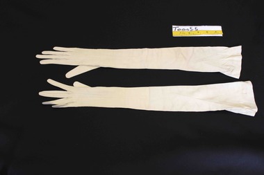 Brighton Historical Society
Accessory - Gloves, 1900
These gloves belonged to Clara Johnstone Miller (nee Bell, 1866-1910). Clara was the only daughter of Mr James Bell, a councillor of the Shire of Leigh (today a part of Golden Plains Shire) and owner of Woolbrook Homestead in Teesdale, near Geelong. In 1888, Clara married prominent businessman, racehorse owner, racing identity and pastoralist Septimus Miller (1854-1925). Septimus was the sixth of seven children born to Henry 'Money' Miller and Eliza Miller (nee Mattinson). 'Money' Miller was a well known financier and politician and reputedly one of Australia's wealthiest people in his time. In 1889, Clara and Septimus moved into the house 'Cantala' in Dandenong Road, Caulfield. They had one child, Gwendoline Stewart Miller, who died in 1902 at the age of thirteen of diabetes - a largely untreatable condition at the time (insulin would not be discovered until 1921). Clara died in 1910, aged only 44. Septimus subsequently married Helen (nee Henderson), with whom he had a son, Ronald (1915-1990). The Millers were buried in the Brighton General Cemetery in a large Gothic-style vault. Upon Clara's death, Septimus sent much of her clothing and Gwendoline's to her mother Mary Bell. Some of these items were passed down to two of Clara's nieces, Miss Mary Bell and Mrs Lois Lillies, who donated them to BHS around 1973.A pair of very fine ivory doeskin evening gloves. The gloves feature full pique insert seams around the fingers and thumb with a slit on the inside arm from mid thumb to mid fore arm and three white shell buttons. The gloves extend high to high on the upper arms and feature a ribbon covered elastic to aid hold on the upper arm. A black ink stamp on the inside of the right glove over the wrist: 5 3/4, Made in France, Buckley and Nunn Limited, Melbourne. A black ink stamp on the inside of the left glove over the wrist: Grand Prix Exposition, 1900, Medallere D'or, Merlier, Depose (? Very faint), Made in France. A blue ink stamp on the inside of the left glove over the top side of the wrist: 797, 221'65, C51Cwoolbrook, septimus miller, henry 'money' miller, gwendoline miller, cantala, clara miller, gloves, caulfield, brighton general cemetery, 1900s fashion, buckley and nunn -
 Brighton Historical Society
Clothing - Dressing gown, circa 1894
This dressing gown belonged to Clara Johnstone Miller (nee Bell, 1866-1910). Clara was the only daughter of Mr James Bell, a councillor of the Shire of Leigh (today a part of Golden Plains Shire) and owner of Woolbrook Homestead in Teesdale, near Geelong. In 1888, Clara married prominent businessman, racehorse owner, racing identity and pastoralist Septimus Miller (1854-1925). Septimus was the sixth of seven children born to Henry 'Money' Miller and Eliza Miller (nee Mattinson). 'Money' Miller was a well known financier and politician and reputedly one of Australia's wealthiest people in his time. In 1889, Clara and Septimus moved into the house 'Cantala' in Dandenong Road, Caulfield, where they hosted lavish receptions for Melbourne's elite. Clara was known as a stylish hostess who wore elegant imported fashions. This dressing gown is believed to have been manufactured by Japanese silk merchant Shiino Shōbei. Following the opening of the port of Yokohama to foreign trade in 1859, Shōbei began producing western-style silk garments, initially selling them to foreigners living in Japan and later exporting them around the world, even exhibiting at the Melbourne International Exhibition of 1880. His popular exports included quilted 'at-home' gowns or dressing gowns similar to this one. They had one child, Gwendoline Stewart Miller, who died in 1902 at the age of thirteen of diabetes - a largely untreatable condition at the time (insulin would not be discovered until 1921). Clara died in 1910, aged only 44. Septimus subsequently married Helen (nee Henderson), with whom he had a son, Ronald (1915-1990). The Millers were buried in the Brighton General Cemetery in a large Gothic-style vault. Upon Clara's death, Septimus sent much of her clothing and Gwendoline's to her mother Mary Bell. Some of these items were passed down to two of Clara's nieces, Miss Mary Bell and Mrs Lois Lillies, who donated them to BHS around 1973.A hand stitched purple pink silk quilted dressing gown with pale pink embroidery from circa 1894. The dressing gown is embroidered from the collar and shoulders though the centre front body to just above the hemline, on the cuffs and remaining pocket in a pale pink Perle thread embroidery featuring leaves and flowers. The entire gown is hand quilted with vertical parallel lines. The gown's neckline features a flat collar and the sleeve head fits on the neat shoulder line. The sleeve head is gathered and full tapering to a loose flat cuff at the wrist. The front of the garment is currently secured by fourteen decorative frogs of two different styles, none of which appear to be original. There is also evidence of a fifteenth toggle that has been removed from the base. The gown's original left hand pocket has been removed and attached to an area around the right breast presumably to patch a hole or obscure some damage. It is unknown when these modifications have been made. The back of the gown features a gathered pink and black concertina pleated silk insert panel from the neck through to the base of the garment. The garment is lined with a very fine pale pink silk over the woollen batting.clara miller, woolbrook, septimus miller, cantala, gwendoline miller, caulfield, brighton general cemetery, shiino shobei, s. shobey -
 Port Fairy Historical Society Museum and Archives
Photograph
Boodcarra - I Ritchie EsqBlack and white photograph of side wall of Boodcarra homestead and view to the Goose Lagoon Swampboodcarra, i ritchie esq -
 Port Fairy Historical Society Museum and Archives
Photograph
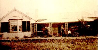
... Street Port Fairy great-ocean-road Leura Station homestead owned ...Leura Station homestead owned by Horace Flowers EsqBlack and white photograph of Leura station homestead with several women and children standing outsideleura, h flowers esq, house, station, farm, princes highway, building, horace -
 Port Fairy Historical Society Museum and Archives
Photograph - Photographs
Aringa StationFive black and white photographs of Buildings on Aringa Stationaringa station, homestead, bakehouse, blacksmith shop -
 Port Fairy Historical Society Museum and Archives
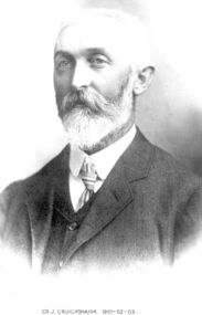
Photograph, Cr J Cruickshank Shire of Belfast President 1901-02-03
Councillor J Cruikshank. Owned “Terka” station near Kirkstall. The property had for some years sheltered and fed a number of kangaroos and he expressed the wish that they would be given a home there. The homestead is a bluestone building with a shingle roof, built by Robert Ireland of Port FairyBlack and white portrait of a male with a beard and moustachebelfast, president, portrait, government, shire, council, municipal, local-government, terka, kirkstall, cr j cruikshank -
 Port Fairy Historical Society Museum and Archives
Photograph, Leura
... Street Port Fairy great-ocean-road Leura homestead owned by Dick ...Leura homestead owned by Dick and Mary Fry. They appear on the verandah in this photoSepia Photographhomestead, building, home, house, leura -
 Wonga Park Community Cottage History Group
Photograph (sub-item) - Black and White, Yarra Brae’ homestead, probably during the ‘sixties’
-
 Wonga Park Community Cottage History Group
Photograph (sub-item) - Black and White, Heims family picking fruit on their property near corner of Toppings and Homestead Roads in 1930’s
... on their property near corner of Toppings and Homestead Roads in 1930’s ... -
 Wonga Park Community Cottage History Group
Photograph (Item) - Black and White, Stane Brae Homestead at Wonga Park, c. 1931
Stane Brae Homestead at Wonga ParkPhoto is named 14880019.jpg on CD -
 Melton City Libraries
Document, Darlingsford land title, 1863
Thomas Bell Darling purchased 176 acres from the Toolern Creek to Ferris Road. A house and bluestone barn/stables were built. The property was owned by Ralph Parkinson, followed by Richard Manning. SUMMARY – Darlingsford – Auction 1910 Darlingsford – Auction 1910 Melton Express October FRIDAY, October 28th At Three O’Clock At the RAGLAN HOTEL, MELTON SUBDIVISIONAL SALE of the DARLINGSFORD ESTATE, MELTON. Having a long frontage to the TOOLERN CREEK. In the Estate of the late RICHARD MANNING’ W. S. KEAST and L.A. FAIRBAIRN & CO., Auctioneers (in conjunction). Have received instructions from R.F. and J.L. Robertson, executors of Richard Manning deceased to offer by Public Auction, property almost adjoining Melton township, and having a frontage to the Toolern Creek, subdivided in to four lots as under:- Lot 1. – The homestead block containing 176 acres, being portion A, section 11, parish Kororoit together with the improvements, which consist of a 6-roomed stone house, milking shed, dairy, U.G. tank. Lot 2 – 177 acres 2 rood 23 perches, being Crown portion B of section 11 parish Kororoit. This block adjoins the homestead and is partly fenced. Lot 3 – 187 acres, Crown allotment C, section 11, parish Kororoit. adjoining the above lot. Lot 4 - 157 acres 1 rood 27 perches, being Crown allotment 9, section 12, parish of Kororoit. This block is only divided from the above lots by road, and adjoining Messrs. McVean and Gaitskill’s properties. This is one of the best known properties in the Melton district as a cultivation an grazing form, and its close proximity to the township makes it a very valuable, and portion of which could be cut into township blocks and should command a ready sale. For absolute sale. Terms- one fifth cash, one fifth in eight years, balance in 7 years with interest a the rate of 4 1/2 percent. Plan on application For further particulars apply W.S. KEAST, 610 Collins street, Melbourne; and L.A. FAIRBAIRN & Co., St James-buildings, Williams street, or at Bacchus Marsh; and as to the title, Dugdale and Creber, St. James-buildings, William Street Melbourne. Express November 5, 1910 On Friday last, Mr W.S. Keast and Messrs L.A. Fairbairn & Co., in conjunction, offered at the Raglan the Manning Estate known as Darlingsford, comprising of 700 acres, divided into four lots. Lot 4 was submitted first and passed in at L8 per acre. Lot 1 was then put up and went up to L13 per acre, at which it was also passed in. Lot 3 was next offered, and there being no bid was also passed in. Lot 2 was not offered. Express March 18, 1911 The Manning Estate of Darlingsford 600 acres was sold to Mr. Ernie for an undisclosed price. Note: Map KOROROIT COUNTY OF BOURKE Crown Grant Section 11 Portion A Thomas. B. Darling 176 . 0 . 0 acres on 29.3.1853 Lot 1 Portion B A. Russell 170 . 0 . 0 acres on 29.3.1853 Lot 2 Portion C Peter Inglis 176 . 0 . 0 acres on 29.3.1853 Lot 3 Section 12 Portion 3 P. Inglis 157 . 1 . 27 acres on 17.17.1863 Total 176 170 176 157. 1.27 679 . 1.27 acres November 5th 1910 On Friday night last Mr W S Keast and Messrs L A Fairbairn & Co, in conjunction offered at the Raglan Hotel the Manning Estate known as Darlingsford, comprising of 700 acres, divided into four Lots. Lot 4 was submitted first, and was passed in at L8.0.0. per acre. Lot 1 was then put up and went to L13.0.0. per acre at which it was passed in. Lot 3 was next offered, and then Lot 3 was next offered, and then being no bid was passed in. Lot 2 was not offered. October 22nd Notice of sale. 700 acres of splendid land close to the railway station. Divided onto 4 Lots 3 of which are maiden land and the whole of the acres is chocolate soil. No 1 Lot belonged to the late Mr Ralph Parkinson, and for years was liberally supplied with manure and crushed bones, and is capable of producing many crops.. The property being sold to wind up the Estate. Gisborne Gazette Friday December 17th 1911 Mr Sharp has sold his farm at the back of the township to Mr. E Barrie; price L15/10/ per acre. Agreement between Thomas Bell Darling and Ralph Parkinsonlocal identities -
 Melton City Libraries
Map, Streets of Melton, 1963
MELTON’S STREETS Heritage Week 2014 What’s in a Name? Alphabetical List Aboriginal place names, Early Family Names and landowners, Agricultural, Shop and Commercial premises, Places and Events Melton & District Historical Society Street Naming Project 1972 – c 1998 Suburb Name – KURUNJANG - Kirkton, 1972, Brookfield, West, 1988 Melton and Town Centre - A joint collaboration with the Shire of Melton and Subdivision Developers ARNOLD Court – Family house - Arnolds Creek ALKEMADE Drive Family – Lime kilns Coimadia ALEXANDRA Street 1902 – Corination of King Edward VII and Queen Alexandra AVIATOR Place Event, location of plane crash – Jimmy Melrose 1936 Adina ?Annibee - Anniba? Agricultural Avon court .. .. BAKERY Square - Location of Jongebloed shop, bakehouse and stables BALUK Place Aboriginal BARLEYCORN Place Agricultural BILLING Place Name of Jimmy Melrose Uncle Noel Pemberton Billing BLACKWOOD Drive - Alexander Blackwood 1860c Registrar BARRIES Road C. E. Barrie “Darlingsford” farmer 1911, chaff mill owner BROOKLYN Road Staughton family residence. 1875 – Dismantled c 193? CAHILL Drive Family - Glenville Dairy CAMERON Court Family Canopus Place ? CANALLAN Drive Early Surveyor CAMPBELL Court Aviation – Melrose passenger 6th July 1936 CARBERRY Drive Michael, early landowner family CAREW Court Edward and Michael. Royal Hotel. Vera (Carew) Forran Singer - Opera CASEY Court Family CASHIN Court Family CHEVIOT Court Agriculture, breed of sheep CHESNEY Road was re named ( Minns Road being duplicated c 1973) CHRISTINA Crescent Christina McPherson, daughter of James and Mary Mary McPherson. Died 1955 aged 85 years COLLYER Close a deleted street (parallel to Yuille) re-used CORRIEDALE Road Breed of sheep CORR Court Teacher at first school, landowner CROXTON Court Name of the Hornbuckle and Knox family home DALEY Court - William Daley and family 1865 Bootmaker High Street DARLINGSFORD Boulevard - Name of early homestead Thomas B Darling 1853 DJERRIWARRH Court - Parish County of Bourke - very early map. DODEMAIDE Place Early land owners - Melton Football Team had 6 brothers playing c 1924 DONALD Court McPherson family 6 generations in Melton in 1936 DOUGAL Court DUNCAN Court .. .. DUNVEGAN Circuit Home of the McPherson family, castle Isle of Skye Name of bluestone house Smith Street (now at Willows) EMIL Court Jongebloed family EXELL Avenue Farming family Melton Sth- Closer Settlement 1907 EXFORD Road Exe former name of the Werribee river FARMER Court Name of early postmistress FERRIS Road John Ferris Farmer HANNAH Close First name of Hannah Watts – midwife HAYBALE Place Agricultural HELDER Court Early surveyor J Helder Wedge map HEWSON Street Winston Hewson Shire Engineer – check title c 1960 HENRY Street Township map c 1860 HESTON Street Heston Phoenix – C.J. Melrose plane HILDEGARDE Court Jimmy Melrose’s mothers name HOMESTEAD Close HORNBUCKLE Cres Farmers. Three members of family - Shire Presidents HURLEY Street Farmers IAIN Court Descendent of James and Mary McPherson JAMES MELROSE Drive Name appears on 2013 Melton information map JANG Place KURUN – jang KIRKTON Drive Name of the McPherson family home Toolern Vale Road KIRWIN Street Michael early landowners (deleted for freeway construction) KILPATRICKS Road Deleted when Barries Road was extended across Station Rd KOROROIT Court Early map, Parish of Kororoit. Creek name KNOX Circuit Family – Hornbuckle “Croxton Park” KURRUNJANG Drive Aboriginal name for people of the red earth – Suburb name Lara Place ? LLOYD Court Garage owners High Street. Laura lived to 100 years D 1955 LUBY Court John Luby – Crown Grant Land Title LITTLE Court MANNING Avenue Richard, hotel owner 1891 MARGARET Drive McPherson family McDONALD Street Melton South family name McKENZIE Street Township c1860 MORROW Street Early name MOWBRAY Crescent Name of English Melton, popularly believed origin of Melton MYERS Court Early setters c 1866 Crown Grant Land Title NIMMO Street Early name NIXON Street Name submitted by Mary nee Nixon Collins c1985 OLDERSHAW Road Early builder PALMERSTON Street Early township map c 1860 PEART Court Early name PENNYROYAL Avenue Plant growing by the creek. Early name used for the Toolern Toolam Creek PINKERTON Street Family name and early street map PINNACLE Crescent Agricultural - type of wheat PHOENIX Circuit C.J. Melrose Phoenix Heston Plane 2013 map PRATT Family PRIOR Court PYKE Place Brothers – early settlement 1838 RADFORD Court Land owners and business operators. Former Royal Hotel Grocer High Street demolished 1970 RAGLAN Court Hotel 19th century Lord Raglan RALEIGHS Road Oliver Reierson family (Norweigen) Shopkeeper – Dressmakers RIDDELL Drive (misspelt Riddle) Resident and land owner RODERICK Road McPherson family – a re occurring name ROLLAND Court Jones family ROSS Court Daniel. Landowner. Agnes Ross music teacher RUSSELL Court Robert. Early land surveyor of Melton 1853 RYAN Court Family early landowner. Member of the 1862 Road Board SHEBLER Place Augustus early Melton resident – Golden Fleece Hotel SHEEPFOLD Court Farming SHERWIN Court Sherwin Street earliest Township map– became Golf course SMITH Street Early township map. STRATHULLOH Circuit Strathtulloh Homestead. STAUGHTON Street Family – LARGE land owners Strachan ? SWANEY Court Marie Swaney earlier resident of Strathtulloh. SUTHERLAND Family name TOOLERN Street TOOLAM – TOOLERN Creek TULLIDGE St Road marked on 1861 map UNITT Street Early Township c 1860 WALLACE Square Cr Jack Wallace 5 terms as President 46 years unopposed WATTS Court Hannah Watts – midwife, cottage hospital WALSINGHAM Name of house of Minns family. From Walsingham Norfolk England WESTLEY Place Name of Jimmy Melrose Percival Gull Plane WESTLAKE Drive Early resident WHICKHAM Street Family Name Melton South WILSON Road Albert, Melton South YUILLE Street William Cross, early landowner, Rockbank run Zoomed in section of Melton Streets including Church and High Streetlandscapes of significance