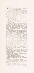
Showing 527 items
matching land owners
-
 Tatura Irrigation & Wartime Camps Museum
bottles, unknown
... , Tatura opposite Lake Bartlett in 1999 by owners of the land who... Street, Tatura opposite Lake Bartlett in 1999 by owners ...all bottles found in old well on site of old Bartlett's Cordial Factory on corner of Francis Street and Service Street, Tatura opposite Lake Bartlett in 1999 by owners of the land who were clearing land to build units9 bottles, 7 glass and 2 pottery - 1)pottery, colour stone & light tan, inscription in black "drink good old ginger beer brewed by J. Bartlett & Co Tatura" and "This bottle is the sole property of J.Bartlett & Co. and must not be used by any other persons."|2)pottery, colour stone & brown, inscription in black "drink good old ginger beer made by J. Bartlett & Co Tatura" and "This bottle is the sole property of J.Bartlett & Co. Tatura" Stamped into pottery is oval stamp with words "Govancroft of Glasgow" and the number 1.|3)clear glass bottle with inscription in glass "J.Bartlett & Co. J.B. Rushworth & Tatura" and "This bottle is the property of J.Bartlett & Co" and "Lemonade" and a small number 2. On base is "M5 29, a symbol and M".|4)clear glass bottle with inscription in glass "J.Bartlett & Co. J.B. Rushworth & Tatura" and "This bottle is the property of J.Bartlett & Co" and "Lemonade" and a small number 2. On base is "M5 29, a symbol and M".|5)green glass bottle with marble in neck with inscription in glass "J.Bartlett & Co. JB & Co Trade Mark Rushworth & Tatura" and "This bottle is the property of J.Bartlett & Co" and "Lemonade" . On base is letter "M".|6)green glass bottle with inscription in glass "J.Bartlett & Co. J.B. Rushworth & Tatura" and "This bottle is the property of J.Bartlett & Co" and a small number 4 . On the base is letters M750, M and ACM.|7)clear glass bottle with inscription in glass "J.Bartlett & Co. J.B. Rushworth & Tatura" and "This bottle is the property of J.Bartlett & Co". On base is ACM.|8)clear glass bottle with inscription in glass "J.Bartlett & Co. J.B. Rushworth & Tatura" and "This bottle is the property of J.Bartlett & Co" and small number 1. On base is M749, M and ACM.|9)clear glass bottle with fancy pattern on neck with inscription in glass "J.Bartlett & Co. J.B. Rushworth & Tatura" and "This bottle is the property of J.Bartlett & Co". On base is L567, M and ACM.tatura, bartlett, drink, bottle, glass, pottery, industry, smith, reynolds, technology, bottles, ceramics, stoneware -
 Victorian Aboriginal Corporation for Languages
Periodical, Australian Institute of Aboriginal and Torres Strait Islander Studies, Australian Aboriginal studies : journal of the Australian Institute of Aboriginal and Torres Strait Islander Studies, 2008
1. Rock-art of the Western Desert and Pilbara: Pigment dates provide new perspectives on the role of art in the Australian arid zone Jo McDonald (Australian National University) and Peter Veth (Australian National University) Systematic analysis of engraved and painted art from the Western Desert and Pilbara has allowed us to develop a spatial model for discernable style provinces. Clear chains of stylistic connection can be demonstrated from the Pilbara coast to the desert interior with distinct and stylistically unique rock-art bodies. Graphic systems appear to link people over short, as well as vast, distances, and some of these style networks appear to have operated for very long periods of time. What are the social dynamics that could produce unique style provinces, as well as shared graphic vocabularies, over 1000 kilometres? Here we consider language boundaries within and between style provinces, and report on the first dates for pigment rock-art from the Australian arid zone and reflect on how these dates from the recent past help address questions of stylistic variability through space and time. 2. Painting and repainting in the west Kimberley Sue O?Connor, Anthony Barham (Australian National University) and Donny Woolagoodja (Mowanjum Community, Derby) We take a fresh look at the practice of repainting, or retouching, rockart, with particular reference to the Kimberley region of Western Australia. We discuss the practice of repainting in the context of the debate arising from the 1987 Ngarinyin Cultural Continuity Project, which involved the repainting of rock-shelters in the Gibb River region of the western Kimberley. The ?repainting debate? is reviewed here in the context of contemporary art production in west Kimberley Indigenous communities, such as Mowanjum. At Mowanjum the past two decades have witnessed an artistic explosion in the form of paintings on canvas and board that incorporate Wandjina and other images inspired by those traditionally depicted on panels in rock-shelters. Wandjina also represents the key motif around which community desires to return to Country are articulated, around which Country is curated and maintained, and through which the younger generations now engage with their traditional lands and reach out to wider international communities. We suggest that painting in the new media represents a continuation or transference of traditional practice. Stories about the travels, battles and engagements of Wandjina and other Dreaming events are now retold and experienced in the communities with reference to the paintings, an activity that is central to maintaining and reinvigorating connection between identity and place. The transposition of painting activity from sites within Country to the new ?out-of-Country? settlements represents a social counterbalance to the social dislocation that arose from separation from traditional places and forced geographic moves out-of-Country to government and mission settlements in the twentieth century. 3. Port Keats painting: Revolution and continuity Graeme K Ward (AIATSIS) and Mark Crocombe (Thamarrurr Regional Council) The role of the poet and collector of ?mythologies?, Roland Robinson, in prompting the production of commercial bark-painting at Port Keats (Wadeye), appears to have been accepted uncritically - though not usually acknowledged - by collectors and curators. Here we attempt to trace the history of painting in the Daly?Fitzmaurice region to contextualise Robinson?s contribution, and to evaluate it from both the perspective of available literature and of accounts of contemporary painters and Traditional Owners in the Port Keats area. It is possible that the intervention that Robinson might have considered revolutionary was more likely a continuation of previously well established cultural practice, the commercial development of which was both an Indigenous ?adjustment? to changing socio-cultural circumstances, and a quiet statement of maintenance of identity by strong individuals adapting and attempting to continue their cultural traditions. 4. Negotiating form in Kuninjku bark-paintings Luke Taylor (AIATSIS) Here I examine social processes involved in the manipulation of painted forms of bark-paintings among Kuninjku artists living near Maningrida in Arnhem Land. Young artists are taught to paint through apprenticeships that involve exchange of skills in producing form within extended family groups. Through apprenticeship processes we can also see how personal innovations are shared among family and become more regionally located. Lately there have been moves by senior artists to establish separate out-stations and to train their wives and daughters to paint. At a stylistic level the art now creates a greater sense of family autonomy and yet the subjects link the artists back in to much broader social networks. 5. Making art and making culture in far western New South Wales Lorraine Gibson This contribution is based on my ethnographic fieldwork. It concerns the intertwining aspects of the two concepts of art and culture and shows how Aboriginal people in Wilcannia in far western New South Wales draw on these concepts to assert and create a distinctive cultural identity for themselves. Focusing largely on the work of one particular artist, I demonstrate the ways in which culture (as this is considered) is affectively experienced and articulated as something that one ?comes into contact with? through the practice of art-making. I discuss the social and cultural role that art-making, and art talk play in considering, mediating and resolving issues to do with cultural subjectivity, authority and identity. I propose that in thinking about the content of the art and in making the art, past and present matters of interest, of difficulty and of pleasure are remembered, considered, resolved and mediated. Culture (as this is considered by Wilcannia Aboriginal people) is also made anew; it comes about through the practice of artmaking and in displaying and talking about the art work. Culture as an objectified, tangible entity is moreover writ large and made visible through art in ways that are valued by artists and other community members. The intersections between Aboriginal peoples, anthropologists, museum collections and published literature, and the network of relations between, are also shown to have interesting synergies that play themselves out in the production of art and culture. 6. Black on White: Or varying shades of grey? Indigenous Australian photo-media artists and the ?making of? Aboriginality Marianne Riphagen (Radboud University, The Netherlands) In 2005 the Centre for Contemporary Photography in Melbourne presented the Indigenous photo-media exhibition Black on White. Promising to explore Indigenous perspectives on non-Aboriginality, its catalogue set forth two questions: how do Aboriginal artists see the people and culture that surrounds them? Do they see non-Aboriginal Australians as other? However, art works produced for this exhibition rejected curatorial constructions of Black and White, instead presenting viewers with more complex and ambivalent notions of Aboriginality and non-Aboriginality. This paper revisits the Black on White exhibition as an intercultural event and argues that Indigenous art practitioners, because of their participation in a process to signify what it means to be Aboriginal, have developed new forms of Aboriginality. 7. Culture production Rembarrnga way: Innovation and tradition in Lena Yarinkura?s and Bob Burruwal?s metal sculptures Christiane Keller (University of Westerna Australia) Contemporary Indigenous artists are challenged to produce art for sale and at the same time to protect their cultural heritage. Here I investigate how Rembarrnga sculptors extend already established sculptural practices and the role innovation plays within these developments, and I analyse how Rembarrnga artists imprint their cultural and social values on sculptures made in an essentially Western medium, that of metal-casting. The metal sculptures made by Lena Yarinkura and her husband Bob Burruwal, two prolific Rembarrnga artists from north-central Arnhem Land, can be seen as an extension of their earlier sculptural work. In the development of metal sculptures, the artists shifted their artistic practice in two ways: they transformed sculptural forms from an earlier ceremonial context and from earlier functional fibre objects. Using Fred Myers?s concept of culture production, I investigate Rembarrnga ways of culture-making. 8. 'How did we do anything without it?': Indigenous art and craft micro-enterprise use and perception of new media technology.maps, colour photographs, b&w photographswest kimberley, rock art, kuninjku, photo media, lena yarinkura, bob burruwal, new media technology -
 Hume City Civic Collection
Correspondence Book, c1890s
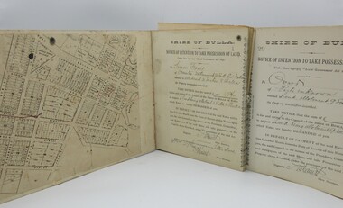
A book with printed perforated pages to send one half to owner of property demanding outstanding payment of rates prior to Council taking possession of land.A mottled blue and brown hard cover book with black spine. Printed and handwritten pages. Printed pattern very worn on front and back covers."Shire of Bulla/Notice of Intention..."1890s, shire of bulla, george evans collection -
 Peterborough History Group
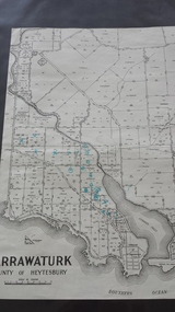
Map - Map of Curdies River Inlet district, Narrawaturk
... at the time Significant as it shows owners of rural land ...Shows the allotment boundaries and names of landowners at the timeSignificant as it shows owners of rural land in the Peterborough area.Photocopy of an old mapHandwritten notes and markings on the map.peterborough, curdies river, curdies river inlet, old maps, maps, narrawaturk -
 Torquay and District Historical Society
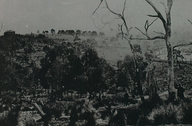
Black & White photocopy, Bellbrae Cemetery Memorial Exhibition 2015
... was the listed owner in 1888 ( land of the Magpie) ... of Liamberis.C j Cook was the listed owner in 1888 ( land of the Magpie ...Photographs donated by Valda ConnellyGundry descententsIron Bark Station was purchased by Joseph Gundry in 1844 The property consisted of 7721 acres plus conditional rights to adjoining properties.The station housed 6000 sheep and 60 cattle . In the top left hand corner of the photograph you can see the LLAMBERIS House built by Joseph Gundry. It was thought that later the property was sold and Roderick Impey Murchison was the buyer,he later offered it for sale in 1885 and later that year A N Hassall invited tenders for lots of Liamberis.C j Cook was the listed owner in 1888 ( land of the Magpie) -
 National Wool Museum
Painting, The White Farm, 2020/21
The farm buildings that Linda Gallus has studied and painted are on the farmland adjoining the Leura Park properties in Curlewis, on the Bellarine Peninsula. The current owner of the property told Linda that he bought the farm in 1994. He has used it for both sheep and cattle grazing since purchasing the property. When the farmer bought the land all the buildings on the property were painted white for sale, despite the fact they were very old. The shearing shed was in use up until the time of sale but was in a bad state of disrepair. The roof, stumps and floor required replacing. The building was no longer in use after the sale, so the shearing shed gradually fell into further disrepair. The previous owner had also used the property for growing potatoes, crops and livestock, mainly sheep. Linda’s fascination with the property came when she caught a glimpse of the white chimney over the hill driving towards Point Lonsdale, which still stands proud today on the roof of the old shearing shed. The owner kindly allowed her to visit the property over the past few years to capture the buildings using photography and painting. During this time many of the buildings have fallen. Linda calls it The White Farm as there are remnants of that original white paint on the outside of most of the buildings giving it a strange and rather beautiful patina. The structures are wonderful remnants of the history of the Bellarine. Linda first spotted the old shearing shed when she was driving home to Clifton Springs from Geelong. It was the white chimney on the shearing shed that stood out behind the rolling grassy hills. It was intriguing – bright white and still in good condition, unlike the rest of the building. After further investigation Linda got to know the owner of the property and visited it frequently to draw, take photos and paint. There is a variety of lovely old buildings on the property, but it was the shearing shed that held extra fascination for Linda. The most intriguing thing for Linda was that the buildings were all painted white at some stage and now the patina of peeling paint and bleached timber brought a wonderful mood and feeling to the farm. This is what she has tried to capture in this series of 11 paintings. Most of the buildings are falling, so Linda felt an urgency to capture them using acrylic paint on canvas in order to commemorate them forever.Acrylic Paint on Canvas. The images both feature a falling down shearing shed as the central focus. The wood of the shearing shed is a central theme of importance. The old buildings were painted white for sale despite being in a state of structural instability. After time this same painted wood has been left with an interesting complex patina like film on the surface which the artist has taken great care to capture. Image 1 is titled ‘Another gust of Wind’. It shows the exterior of the shearing shed which is in the process of collapsing from the forces of mother nature. In the background of this painting another of the buildings in the ‘White Farm’ complex is visible, in addition to blue skies and overgrown green grasses. Image 2 is titled ‘Green Trough’. It features the interior of the same collapsing shearing shed. The image is painted as though the viewer is peering through a crack of the external wall. Internally a green trough is seen hanging on an internal fence. Unlike everything else in the shearing shed, the trough appears new and in good condition. It provides a strong juxtaposition to the rest of the shearing shed, and the larger surrounding ‘White Farm’ complexbellarine peninsula, the white farm, shearing shed -
Koorie Heritage Trust
Book, Brambuk Living Cultural Centre, A Journey Through Time, 1990
... the traditional owners of the land in and around the magnificent ...Intro.: Brambuk welcomes you to a journey through time. A journey that will take you through the experiences of our people the Yardwadjali and Djap Wurrung the traditional owners of the land in and around the magnificent and powerful mountain range of Gariwerd our ancient name for the Grampians...15 p. : ill. (some col.) ; 21 x 30 cm.Intro.: Brambuk welcomes you to a journey through time. A journey that will take you through the experiences of our people the Yardwadjali and Djap Wurrung the traditional owners of the land in and around the magnificent and powerful mountain range of Gariwerd our ancient name for the Grampians...community organisations -- cultural activities (including preservation and/or promotion of traditional culture). other: brambuk living cultural centre -- budja budja -- gariwerd -- halls gap. -
Whitehorse Historical Society Inc.
Map, A Plan of part of the Parish of Nunawading, 1984
... Hand drawn plan showing the owners or occupiers of land... drawn plan showing the owners or occupiers of land c1860'. Hand ...Hand drawn plan showing the owners or occupiers of land c1860'.Hand drawn plan showing the owners or occupiers of land c1860'. Includes proposed townships of New Brunswick and Norwich. Scate 1 inch : 10 chains.Hand drawn plan showing the owners or occupiers of land c1860'. maps, shire of nunawading -
Whitehorse Historical Society Inc.
Article, Traders Trapped, 1985
... by the Road Construction Authority, owner of the land.... by the Road Construction Authority, owner of the land.... by the Road Construction Authority, owner of the land. Land Use ...Eight Businesses at Houston Shopping Centre, Middleborough Road, Box Hill.Eight Businesses at Houston Shopping Centre, Middleborough Road, Box Hill, facing rezoning of land reserved for the Healesville Freeway. Traders say they are being treated unfairly by the Road Construction Authority, owner of the land.Eight Businesses at Houston Shopping Centre, Middleborough Road, Box Hill. land use, anderson camp -
Whitehorse Historical Society Inc.
Article, Family Digs In Over Land, 2016
The level crossing removal Authority intended to use a narrow strip of land next to the railway tracks in Heatherdale Road only to discover that it was privately owned and negotiations are proceeding with the owners.The level crossing removal Authority intended to use a narrow strip of land next to the railway tracks in Heatherdale Road only to discover that it was privately owned and negotiations are proceeding with the owners.The level crossing removal Authority intended to use a narrow strip of land next to the railway tracks in Heatherdale Road only to discover that it was privately owned and negotiations are proceeding with the owners.heatherdale railway station, level crossing removal authority -
 Rutherglen Historical Society
Financial record - Receipt, T. Drenen, 14/8/1914 (Exact)
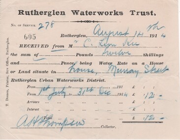
It is believed that the C. Lim Kee who was paying these rates was Charles Lim Kee. According to the Rutherglen Sun September 11, 1896 he was starting a business known as the Cash Bakery in premises previously occupied by Conrad Huhs. In 1903 he moved to new premises next to the Bank of Victoria. By 1908 he had a shop and rooms in Main Street, and houses in Wallace Street and Murray Street. Part of a collection of business documents found under the floor of a building in Main Street when it was being renovated. At that time the owner was Don Chambers, and the premises was occupied as the Chambers Riteway Supermarket. The location (134 Main Street) is currently (2022) occupied by Miegel’s Pharmacy Rutherglen. Receipt from Rutherglen Waterworks Trust for water rates for a house in Murray Street. The form is printed on paper with hand written details reproduced with carbon paper.,"Rutherglen Waterworks Trust, No. of service 278. [receipt no.]: 605. Rutherglen, August 14th 1914. Received from Mr C. Lim Kee the sum of --- Pounds twelve Shillings and --- Pence, being Water Rate on a House or Land situate in house, Murray Street Rutherglen Urban Waterworks District. From 1st July to 31st Dec 1914." Signed A.H. Thompson, Collector.lim kee, rutherglen waterworks trust, water rates, business documents, 134 main street, chambers riteway supermarket -
 Ballarat Heritage Services
Photograph - Colour, Dorothy Wickham, Earth Banks, Old Sarum, England, 2016, 01 November 2016
... to be the first listing of land owners in England. Among the names ...William the Conqueror inherited Old Sarum from the last Saxon king of England. It was an ideal site for a royal castle. It was here in 1070 that William paid off his army after a long and bitter campaign in northern England. It was here in 1086 that he called together all the major landholders in England so they could swear allegiance to him. It was a crucial moment. The Domesday Book was being written, a threatened Viking invasion had only just been averted and William's eldest son was in armed rebellion. Old Sarum was an important place where this Norman king of England held power. In 1794 the Ordnance Survey set out to check the accuracy of the first mapping of Southern England, which had begun ten years earlier. From a point just below Old Sarum Lieutenant William Mudge laid out a base-line 36,574 feet (11,253 metres) long. From each end of the line the positions of distant places were plotted using a huge theodolite made in 1791 by Jesse Ramsden. The accuracy of the process, which was repeated all over England, depended on Jesse Ramsden's craftsmanship and on William Mudge's surveying skill in setting out this first base-line from Old Sarum. The nearer end of Mudge's line is marked by an inscribed stone beside the modern A345 at Old Sarum. King William devised the Domesday Book, considered to be the first listing of land owners in England. Among the names is that of D'Arques, from Normandy, France. Descendants of this family later emigrated from England and settled in Victoria, Australia under the surname 'Dark'. ordnance survey, william mudge, jesse ramsden, william the conqueror, old sarum, saxon, 1086, england -
Ballarat Heritage Services
Book, Dja Dja Wurrung Dhelkunya Dja Country Plan, 2014-2034
non-fictiondja dja wurrung, dhelkunya, cultural heritage, bushtucker, medicine, rivers, waterways, self-determination, joint management, crown land, trent nelson, graham atkinson, native title, traditional owners -
Ballarat Heritage Services
Book, Dhelkunya Dja Joint Management Plan for the Dja Dja Wurrung Parks: Strategy, 2018
... management Crown land Native title traditional owners Language ...non-fictiondja dja wurrung, dhelkunya, cultural heritage, bushtucker, medicine, rivers, waterways, self-determination, joint management, crown land, native title, traditional owners, language -
Unions Ballarat
Select Documents in Australian History 1788-1850, 1950
... land Previous owner's name and pencil notes on front page ...Australian history 1788-1850 Table of contents: 1. The British background 2. The first settlements 3. Transportation 4. Immigration 5. Land policy 6. The squatters 7. Constitutional history 8. Economic and social conditionsConstitution, land, economic and social history pertinent to the period 1788-1850.Hardback; book.Previous owner's name and pencil notes on front page. Cover: authors' names and title.australian history, btlc, ballarat regional trades and labour council, cmh clark, manning clark, economics, social policy, crime, australian settlement, convicts, migration, lands, squatters, constitution, land -
 Whitehorse Historical Society Inc.
Photograph - Playground, 27 Good Governs Rd Mitcham
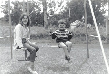
Black and white photographs of a family of 3 at 27 Good Governs Rd with a paddock in the background Approximately 1969On rear of Photo: This was the paddock at the back of No 27 Good Governs Street at one stage Approx 1969 (Now no 12 Irvine St Development of 27 units0 Land was sold for $3.5 million in 2009 by estate of Mr Murray Jones who was the original owner of this parcel of land He purchased the remaining land from the mortgagor of Miss Linda Roberts. John Hay is the boy with his cousins from Ringwoodgood governs rd no 27, irvine st no 12, jones murray -
 Whitehorse Historical Society Inc.
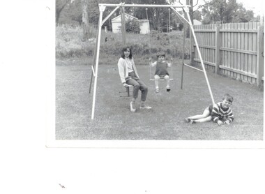
Photograph, 27 Good Governs Rd Mitcham
... Mr Murray Jones was the owner of the land directly behind... Mitcham melbourne Mr Murray Jones was the owner of the land ...Mr Murray Jones was the owner of the land directly behind this house at 27 Good Governs Rd.He later purchased more of the surrounding land. In 2009 his land was sold by the executors of his estate for $3.5 million . Part of the land bordered Irvine St and at no 12 a development of 27 unit was erected. Photo shows comparison between 1969 and present day2 Children on a swing in back yard of 27 Good Governs Rd Mitcham.Refer to NP4307 for full details of photogood governs rd mitcham no 27, irvine st mitcham no 12, jones murray -
Bialik College
Flyer (item) - Ngarrgee, 2020
... for Ngarrgee events 2020- to acknowledge the traditional owners... events 2020- to acknowledge the traditional owners of the land ...Invitations sent to school community and running sheets for Ngarrgee events 2020- to acknowledge the traditional owners of the land, Rosh Hashanah, and to welcome the new Year 12 leadership cohort, the Mazkirut. 'Ngarrgee' is a Wurundjeri word meaning 'coming together'. The school's RAP Committee advised in 2020: 'Following on from the very successful Welcome to Country smoking ceremony in 2019, which was appropriately aligned with Rosh Hashanah, we are continuing with this new tradition by hosting the same event on Tuesday 15 September at 8.00pm via the ZOOM platform. Adapting to current circumstances, the smoking ceremony will be led by Murrundindi, Ngurungaeta (Head Man) for the Wurundjeri clan, from his property in Healesville. This year, the event will also incorporate the Mazkirut Induction ceremony.' Please contact [email protected] to request access to this record. event, celebration, year 12, 2020s -
 Ballarat and District Irish Association
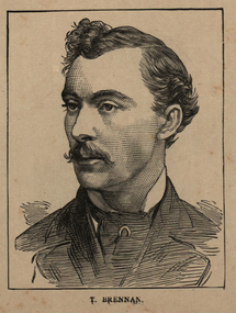
Image, T. Brennan, c1864, 1864
Following the founding meeting of the Mayo Tenants Defence Association in Castlebar, County Mayo on 26 October 1878 the demand for The Land of Ireland for the people of Ireland was reported in the Connaught Telegraph 2 November 1878. The first of many "monster meetings" of tenant farmers was held in Irishtown near Claremorris on 20 April 1879, with an estimated turnout of 15,000 to 20,000 people. This meeting was addressed by James Daly (who presided), John O'Connor Power, John Ferguson, Thomas Brennan, and J. J. Louden. The Connaught Telegraph's report of the meeting in its edition of 26 April 1879 began: Since the days of O'Connell a larger public demonstration has not been witnessed than that of Sunday last. About 1 o'clock the monster procession started from Claremorris, headed by several thousand men on foot – the men of each district wearing a laural leaf or green ribbon in hat or coat to distinguish the several contingents. At 11 o'clock a monster contingent of tenant-farmers on horseback drew up in front of Hughes's hotel, showing discipline and order that a cavalry regiment might feel proud of. They were led on in sections, each having a marshal who kept his troops well in hand. Messrs. P.W. Nally, J.W. Nally, H. French, and M. Griffin, wearing green and gold sashes, led on their different sections, who rode two deep, occupying, at least, over an Irish mile of the road. Next followed a train of carriages, brakes, cares, etc. led on by Mr. Martin Hughes, the spirited hotel proprietor, driving a pair of rare black ponies to a phæton, taking Messrs. J.J. Louden and J. Daly. Next came Messrs. O'Connor, J. Ferguson, and Thomas Brennan in a covered carriage, followed by at least 500 vehicles from the neighbouring towns. On passing through Ballindine the sight was truly imposing, the endless train directing its course to Irishtown – a neat little hamlet on the boundaries of Mayo, Roscommon, and Galway. Evolving out of this a number of local land league organisations were set up to work against the excessive rents being demanded by landlords all over Ireland, but especially in Mayo and surrounding counties. From 1874 agricultural prices in Europe had dropped, followed by some bad harvests due to wet weather during the Long Depression. The effect by 1878 was that many Irish farmers were unable to pay the rents that they had agreed, particularly in the poorer and wetter parts of Connacht. The localised 1879 Famine added to the misery. Unlike other parts of Europe the Irish land tenure system was inflexible in times of hardship. (Wikipedia) The Irish National Land League was founded at the Imperial Hotel in Castlebar, the County town of Mayo, on 21 October 1879. At that meeting Charles Stewart Parnell was elected president of the league. Andrew Kettle, Michael Davitt, and Thomas Brennan were appointed as honorary secretaries. This united practically all the different strands of land agitation and tenant rights movements under a single organisation. Michael Davitt Founder of the Land League The two aims of the Land League, as stated in the resolutions adopted in the meeting, were: ...first, to bring out a reduction of rack-rents; second, to facilitate the obtaining of the ownership of the soil by the occupiers. That the object of the League can be best attained by promoting organisation among the tenant-farmers; by defending those who may be threatened with eviction for refusing to pay unjust rents; by facilitating the working of the Bright clauses of the Irish Land Act during the winter; and by obtaining such reforms in the laws relating to land as will enable every tenant to become owner of his holding by paying a fair rent for a limited number of years. (Wikipedia)Image of a man with a moustache. He is T. Brennan.ballarat irish, brennan, thomas brennan, irish land act, rent -
 Ballarat and District Irish Association
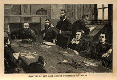
Image, Land League Committee Meeting, Dublin, 1864
The Irish National Land League (Irish: Conradh na Talún) was an Irish political organisation of the late 19th century which sought to help poor tenant farmers. Its primary aim was to abolish landlordism in Ireland and enable tenant farmers to own the land they worked on. The period of the Land League's agitation is known as the Land War. Within decades of the league's foundation, through the efforts of William O'Brien and George Wyndham (a descendant of Lord Edward FitzGerald), the 1902 Land Conference produced the Land (Purchase) Act 1903 which allowed Irish tenant farmers buy out their freeholds with UK government loans over 68 years through the Land Commission (an arrangement that has never been possible in Britain itself). For agricultural labourers, D.D. Sheehan and the Irish Land and Labour Association secured their demands from the Liberal government elected in 1905 to pass the Labourers (Ireland) Act 1906, and the Labourers (Ireland) Act 1911, which paid County Councils to build over 40,000 new rural cottages, each on an acre of land. By 1914, 75% of occupiers were buying out their landlords, mostly under the two Acts. In all, under the pre-UK Land Acts over 316,000 tenants purchased their holdings amounting to 15 million acres (61,000 km2) out of a total of 20 million acres (81,000 km2) in the country. Sometimes the holdings were described as "uneconomic", but the overall sense of social justice was undeniable. (http://en.wikipedia.org/wiki/Irish_National_Land_League, accessed 21 January 2014) The Irish National Land League was founded at the Imperial Hotel in Castlebar, the County town of Mayo, on 21 October 1879. At that meeting Charles Stewart Parnell was elected president of the league. Andrew Kettle, Michael Davitt, and Thomas Brennan were appointed as honorary secretaries. This united practically all the different strands of land agitation and tenant rights movements under a single organisation. The two aims of the Land League, as stated in the resolutions adopted in the meeting, were: ...first, to bring out a reduction of rack-rents; second, to facilitate the obtaining of the ownership of the soil by the occupiers. That the object of the League can be best attained by promoting organisation among the tenant-farmers; by defending those who may be threatened with eviction for refusing to pay unjust rents; by facilitating the working of the Bright clauses of the Irish Land Act during the winter; and by obtaining such reforms in the laws relating to land as will enable every tenant to become owner of his holding by paying a fair rent for a limited number of years. Charles Stewart Parnell, John Dillon, Michael Davitt, and others including Cal Lynn then went to America to raise funds for the League with spectacular results. Branches were also set up in Scotland, where the Crofters Party imitated the League and secured a reforming Act in 1886. The government had introduced the first ineffective Land Act in 1870, then the equally inadequate Acts of 1880 and 1881 followed. These established a Land Commission that started to reduce some rents. Parnell together with all of his party lieutenants, including Father Eugene Sheehy known as "the Land League priest", went into a bitter verbal offensive and were imprisoned in October 1881 under the Irish Coercion Act in Kilmainham Jail for "sabotaging the Land Act", from where the No-Rent Manifesto was issued, calling for a national tenant farmer rent strike which was partially followed. Although the League discouraged violence, agrarian crimes increased widely. Typically a rent strike would be followed by evictions by the police, or those tenants paying rent would be subject to a local boycott by League members. Where cases went to court, witnesses would change their stories, resulting in an unworkable legal system. This in turn led on to stronger criminal laws being passed that were described by the League as "Coercion Acts". The bitterness that developed helped Parnell later in his Home Rule campaign. Davitt's views were much more extreme, seeking to nationalise all land, as seen in his famous slogan: "The land of Ireland for the people of Ireland". Parnell aimed to harness the emotive element, but he and his party preferred for tenant farmers to become freeholders on the land they rented, instead of land being vested in "the people".(http://en.wikipedia.org/wiki/Irish_National_Land_League, accessed 21 January 2014)Image of a number of men sitting around a table. They are members of the Land League Committee during a meeting in Dublin.ballarat irish, land league, land league committee, dublin -
 Ballarat and District Irish Association
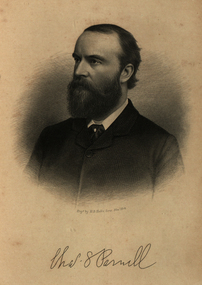
Image, Charles Parnell, c1864, 1864
Parnell was an Irish nationalist and statesman who led the fight for Irish Home Rule in the 1880s. Charles Stewart Parnell was born on 27 June 1846 in County Wicklow into a family of Anglo-Irish Protestant landowners. He studied at Cambridge University and was elected to parliament in 1875 as a member of the Home Rule League (later re-named by Parnell the Irish Parliamentary Party). His abilities soon became evident. In 1878, Parnell became an active opponent of the Irish land laws, believing their reform should be the first step on the road to Home Rule. In 1879, Parnell was elected president of the newly founded National Land League and the following year he visited the United States to gain both funds and support for land reform. In the 1880 election, he supported the Liberal leader William Gladstone, but when Gladstone's Land Act of 1881 fell short of expectations, he joined the opposition. By now he had become the accepted leader of the Irish nationalist movement. Parnell now encouraged boycott as a means of influencing landlords and land agents, and as a result he was sent to jail and the Land League was suppressed. From Kilmainham prison he called on Irish peasants to stop paying rent. In March 1882, he negotiated an agreement with Gladstone - the Kilmainham Treaty - in which he urged his followers to avoid violence. But this peaceful policy was severely challenged by the murder in May 1882 of two senior British officials in Phoenix Park in Dublin by members of an Irish terrorist group. Parnell condemned the murders. In 1886, Parnell joined with the Liberals to defeat Lord Salisbury's Conservative government. Gladstone became prime minister and introduced the first Irish Home Rule Bill. Parnell believed it was flawed but said he was prepared to vote for it. The Bill split the Liberal Party and was defeated in the House of Commons. Gladstone's government fell soon afterwards.(http://www.bbc.co.uk/history/historic_figures/parnell_charles.shtml, accessed 21 January 2014) The Irish National Land League (Irish: Conradh na Talún) was an Irish political organisation of the late 19th century which sought to help poor tenant farmers. Its primary aim was to abolish landlordism in Ireland and enable tenant farmers to own the land they worked on. The period of the Land League's agitation is known as the Land War. Within decades of the league's foundation, through the efforts of William O'Brien and George Wyndham (a descendant of Lord Edward FitzGerald), the 1902 Land Conference produced the Land (Purchase) Act 1903 which allowed Irish tenant farmers buy out their freeholds with UK government loans over 68 years through the Land Commission (an arrangement that has never been possible in Britain itself). For agricultural labourers, D.D. Sheehan and the Irish Land and Labour Association secured their demands from the Liberal government elected in 1905 to pass the Labourers (Ireland) Act 1906, and the Labourers (Ireland) Act 1911, which paid County Councils to build over 40,000 new rural cottages, each on an acre of land. By 1914, 75% of occupiers were buying out their landlords, mostly under the two Acts. In all, under the pre-UK Land Acts over 316,000 tenants purchased their holdings amounting to 15 million acres (61,000 km2) out of a total of 20 million acres (81,000 km2) in the country. Sometimes the holdings were described as "uneconomic", but the overall sense of social justice was undeniable. (http://en.wikipedia.org/wiki/Irish_National_Land_League, accessed 21 January 2014) The Irish National Land League was founded at the Imperial Hotel in Castlebar, the County town of Mayo, on 21 October 1879. At that meeting Charles Stewart Parnell was elected president of the league. Andrew Kettle, Michael Davitt, and Thomas Brennan were appointed as honorary secretaries. This united practically all the different strands of land agitation and tenant rights movements under a single organisation. The two aims of the Land League, as stated in the resolutions adopted in the meeting, were: ...first, to bring out a reduction of rack-rents; second, to facilitate the obtaining of the ownership of the soil by the occupiers. That the object of the League can be best attained by promoting organisation among the tenant-farmers; by defending those who may be threatened with eviction for refusing to pay unjust rents; by facilitating the working of the Bright clauses of the Irish Land Act during the winter; and by obtaining such reforms in the laws relating to land as will enable every tenant to become owner of his holding by paying a fair rent for a limited number of years. Charles Stewart Parnell, John Dillon, Michael Davitt, and others including Cal Lynn then went to America to raise funds for the League with spectacular results. Branches were also set up in Scotland, where the Crofters Party imitated the League and secured a reforming Act in 1886. The government had introduced the first ineffective Land Act in 1870, then the equally inadequate Acts of 1880 and 1881 followed. These established a Land Commission that started to reduce some rents. Parnell together with all of his party lieutenants, including Father Eugene Sheehy known as "the Land League priest", went into a bitter verbal offensive and were imprisoned in October 1881 under the Irish Coercion Act in Kilmainham Jail for "sabotaging the Land Act", from where the No-Rent Manifesto was issued, calling for a national tenant farmer rent strike which was partially followed. Although the League discouraged violence, agrarian crimes increased widely. Typically a rent strike would be followed by evictions by the police, or those tenants paying rent would be subject to a local boycott by League members. Where cases went to court, witnesses would change their stories, resulting in an unworkable legal system. This in turn led on to stronger criminal laws being passed that were described by the League as "Coercion Acts". The bitterness that developed helped Parnell later in his Home Rule campaign. Davitt's views were much more extreme, seeking to nationalise all land, as seen in his famous slogan: "The land of Ireland for the people of Ireland". Parnell aimed to harness the emotive element, but he and his party preferred for tenant farmers to become freeholders on the land they rented, instead of land being vested in "the people".(http://en.wikipedia.org/wiki/Irish_National_Land_League, accessed 21 January 2014)Image of bearded man known as Charles Stewart Parnellballarat irish, parnell, charles parnell, home rule -
 Ambulance Victoria Museum
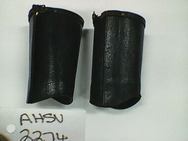
Gaiters, Uniform, Ambulance officer
When he died in 2007, Wally Byrne, left a legacy of public service that many would be proud to emulate. Having served in the Royal Australian Navy in the Pacific during the Second War World War, Wally later joined the Victorian Civil Ambulance as an ambulance officer. In a career that spanned more than 35 years, Wally was based at Lonsdale Street, Latrobe Street and Fairfield. He became Station Officer at the busy Latrobe Street before moving into the Mobile Intensive Care Ambulance (MICA) system. Promoted to District Officer he became officer in charge of communications and served in this role until his retirement. Chas Martin, one of Wally’s communications staff at Latrobe Street, recalled that Wally was an efficient and well liked manager. He was also a very social person. Having purchased a block of land at Christmas Hills, Wally and his family hosted regular weekend BBQ’s there for his communications staff, other ambulance officers, and their families. Wally’s son Jon, later joined Ambulance Victoria, became a paramedic and now holds a senior role in the organisation.Pair of dark brown leather gaiters with metal clips to fasten the side and a small brass buckle and strap at the top. The gaiters are marked in ink on the inside surface 'Left' and 'Right' and are both inscribed with the owners name ' W.BYRNE'. gaiters, uniform, wally byrne -
 Ballarat Tramway Museum
Newspaper, The Courier Ballarat, "Historic Wall", 1953
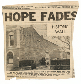
... to a previous land owner. Power Station Newspaper clipping from ...Yields information about a historical wall at the Ballarat Power station and its relationship to a previous land owner.Newspaper clipping from The Courier, 26/8/1953 of a photograph and caption of the bluestone wall at Ballarat A power station, noting it was a remnant of Fry's flour mill. Also notes when the power station foundation stone was laid. Item was contained within Reg Item 5507 - Foolscap binder with green covers, black binding edge and metal clips - see btm5507-list.pdf for actual location. Hi Res scan added 16-12-2015.power station -
 Bendigo Historical Society Inc.
Document - MCCOLL, RANKIN AND STANISTREET COLLECTION: THANET LEASE, 1930's
Manilla folder of documents relating to the application by Herbert Jackson Leed for mining lease No. 10500, called the Thanet Lease. Containing a list of all of the owners of the allotments on the proposed lease and consent forms for them to sign. A map of the lease and of the subdivision of allotments 97 and 92. Various correspondence and application forms.gold, mining, land application, bendigo, gold mining. thanet lease, herbert jackson leed. -
 Bendigo Historical Society Inc.
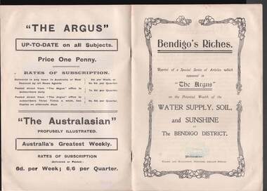
Book - BOOK: BENDIGO'S RICHES
Small booklet titled 'Bendigo's Riches'. Reprint of a Special Series of Articles which appeared in 'The Argus' on the Potential Wealth of the Water Supply, Soil, and Sunshine of The Bendigo District. Printed by Wilson and Mackinnon, Printers, Collins Street. Booklet mentions the potential wealth of Bendigo's Water, Soil and Sunshine; Orchards, Dairying, Tomato Growing, Fruitgrowing, Land, and Water Supply. Also discussed are Antiquated Mining Regulations, City Trust suggested, and its Advantages, Opportunities, 'The Argus' suggestions endorsed, Mine-owner's Opinion, The Mayor of Bendigo's Opinion, Statement by Strathfieldsaye Shire Secretary, Locked-up Area Useless for Timber, Shire Appeals for Unlocking the Land, 'The Argus' Thanked, Bendigo Chamber of Commerce, Bendigo City Council and Preserving Factory at Bendigo. Photos include: Irrigated pastures, rye-grass and clovers on Mr James Cumming's Farm; Irrigating Tomatoes on Mr Elliot Borley's Farm, White Hills; Junction of Huntly and White Hills Irrigation Channels; Packing Tomatoes at Mr B. Puig Y. Ventura's Garden, White Hills; and Tomato Patch on the Holding of Mr T. L. Sweeny, Jun. Back of the booklet has subscription rates and price of The Argus. Missing 8/07/2021place, land, agricultural, book - bendigo's riches, the argus, wilson and mackinnon, councillor carolin, james cumming, dairying, mr elwood mead, tomato growing, mr b puig y ventura, mr elliot borley, fruitgrowers, bendigo fruitgrowers' co-operative society, mr w a hamilton ex-mla, upper coliban, coliban system, antiquated mining regulations, lands department, chaffey bros, mr g h crawford, mine-owners' association, councillor andrew, mr baillieu, miners' association, agricultural society, sir thomas bent, strathfieldsaye shire, mr r b brennan, mr t l sweeny jun, bendigo sewerage farm, councillor osborne, councillor lowndes, councillor t r long, bendigo chamber of commerce, bendigo city council, councillor andrew, councillor h a ross, councillor wilkie, h m leggo and co -
 Kew Historical Society Inc
Plan, Melbourne and Metropolitan Board of Works, Borough of Kew : Detail Plan No.1580, 1904
The Melbourne and Metropolitan Board of Works (MMBW) plans were produced from the 1890s to the 1950s. They were crucial to the design and development of Melbourne's sewerage and drainage system. The plans, at a scale of 40 feet to 1 inch (1:480), provide a detailed historical record of Melbourne streetscapes and environmental features. Each plan covers one or two street blocks (roughly six streets), showing details of buildings, including garden layouts and ownership boundaries, and features such as laneways, drains, bridges, parks, municipal boundaries and other prominent landmarks as they existed at the time each plan was produced. (Source: State Library of Victoria)This plan forms part of a large group of MMBW plans and maps that was donated to the Society by the Mr Poulter, City Engineer of the City of Kew in 1989. Within this collection, thirty-five hand-coloured plans, backed with linen, are of statewide significance as they include annotations that provide details of construction materials used in buildings in the first decade of the 20th century as well as additional information about land ownership and usage. The copies in the Public Record Office Victoria and the State Library of Victoria are monochrome versions which do not denote building materials so that the maps in this collection are invaluable and unique tools for researchers and heritage consultants. A number of the plans are not held in the collection of the State Library of Victoria so they have the additional attribute of rarity.Original survey plan, issued by the MMBW to a contractor with responsibility for constructing sewers in the area identified on the plan within the Borough of Kew. The plan was at some stage hand-coloured, possibly by the contractor, but more likely by officers working in the Engineering Department of the Borough and later Town, then City of Kew. The hand-coloured sections of buildings on the plan were used to denote masonry or brick constructions (pink), weatherboard constructions (yellow), and public buildings (grey). The area represented in this detail plan has undergone significant change during the 20th century. The widening of High Street in the 1930s and 1950s involved the shops on the south side of High Street being demolished and later rebuilt to fit the widened street. Another significant loss was the mansion ‘Drayton’ fronting Wellington Street, owned at this stage by Susannah Fenton. Her family name would later to be given to Fenton Way, which was to be built over the grounds of the house following its demolition. The plan of the garden is particularly interesting, containing a batten dome fronting Wellington Street, an ornamental pond, a fountain and a brick and glass conservatory. The notes by the plumbing contractor on this plan are particularly detailed. Pink borders delineate the ownership of the varying parcels of land. Some of the better known owners listed include the real estate agent Cr. Henry de Castres Kellett (bt) and John Padbury, the funeral director. This particular plan provides a clear view of the configuration of the Kew Junction in 1903 and the commercial buildings that surrounded it.melbourne and metropolitan board of works, detail plans, maps - borough of kew, mmbw 1580, cartography -
 Kew Historical Society Inc
Legal record (Item), Thomas Judd to James Bonwick: Agreement for Sale of Land at Parish of Boroondara, 1853, 28/02/1853
James Bonwick (1817-1906), the Victorian educator and historian, acquired land in Kew on which to establish a home and school in 1853, not 1854 as more commonly stated. Bonwick returned to England in 1859 for a period, later returning to Melbourne and settling in St Kilda. He was the author of a number of histories and an official transcriber of Government records.This newly acquired document, from a former owner of 'Parkhill' (20 Hillcrest Avenue, Kew), is of statewide importance as it is the original copy of the agreement made between Thomas Judd of Parkhill and James Bonwick in 1853 for the purchase of land in Kew. Both Thomas Judd and James Bonwick were significant pioneers of Victoria.TRANSCRIPT [TITLE] Thomas Judd to James Bonwick Agreement for Sale of Land at Parish of Boroondara [PAGE 1] Articles of agreement made and entered into this the Twentyth eighth day of February One thousand Eight Hundred and fifty three Between Thomas Judd of Melbourne in the Colony of Victoria Gentleman of the one part and James Bonwick of Melbourne in the Colony of Victoria Gentleman of the other part whereby the said Thomas Judd agrees to sell unto the said James Bonwick who hereby agrees to purchase a piece or parcel of land containing two and half acres be the land more or less part of Portion Number Eighty five of the Parish of Boroondara in the County of Bourke commencing at a point on the Northern boundary line of the said Portion Seventeen Chains fifty links East from the North West angle of the same and bounded on the East by other part of said Portion in a line bearing South Eight Hundred and sixty two feet on the South by other part of said Portion Eighty five in a line bearing West one Hundred twenty six and half feet on the West by other part of said Portion Eighty five in a line bearing North Eight Hundred and Sixty two feet on the North by the Northern boundary line of the said Portion Eighty five in a line bearing East one Hundred twenty six and half feet to the commencing point at or for the price or sum of one [PAGE 2] One Hundred Pounds to be paid and payable in the manner hereinafter mentioned that is to say the Sum of Thirty pounds to be paid on the day of the date hereof and the sum of forty pounds by the acceptance of the said James Bonwick for that sum at three months bearing interest thereon after the rate of Eight Pounds per centum per annum and the Sum of Thirty pounds by the acceptance of the said James Bonwick for that sum after Six months with interest thereon after the rate of Eight pounds per centum per annum It is furthermore agreed that the said James Bonwick shall have access by a right of way fifteen feet wide reserved by the said Thomas Judd to the Government Road being the Southern Boundary of Portion Eighty five. That in case default shall be made in the payment of any of any of the Acceptances above mentioned the amount paid shall be actually forfeited to the said Thomas Judd who shall be at liberty to resell the premises. That upon payment of the whole amount of the purchase money the said Thomas Judd shall execute a conveyance of the premises to the said James Bonwick Such conveyance to be prepared by and at the expense of the said James Bonwick who - [PAGE 3] who shall also pay the cost of any attested copies he may require. ---- As witness the hands of the said parties this the twenty first day of February one thousand Eight Hundred and fifty Three. ----- [Signature] T. Judd [Signature] Jas Bonwick Witness [Signature illegible] £ Received Cash on account of the above 30.0.0 Thirty Pounds Bill at three Months with interest 42.4.0 Bill at Six Months with interest 31.4.0 _____ £103.8.0 _____ [Signature] T. Judd [Signature] Jas Bonwick ------------ Transcribed David White 25/08/2020 james bonwick, thomas judd, land titles - kew (vic), pioneers - kew - victoria -
Kew Historical Society Inc
Headwear - Cream Silk & Lace Infant's Cap, 1880-1900
... from early pioneers and land-owners in Studley Park, the silk ...Originally designated as a bride's cap, and part of the Coombs collection, the cap has since been identified as an infant's capBelieved to be part of the Coombs collection, which was derived from early pioneers and land-owners in Studley Park, the silk and lace cap is a representative example of infants' clothing from the 19th century. Flat, cream-coloured silk and lace, lozenge-shaped baby’s cap (bonnet). infants' clothing, caps -
 Kew Historical Society Inc
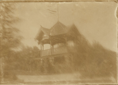
Photograph - Rotunda in the Alexandra Gardens, c.1912
The Alexandra Gardens in Kew face Cotham Road. The land on which the gardens were created was purchased from the owners of 'Madford' in Wellington Street by the Borough of Kew. The rotunda was built to commemorate the jubilee of Kew in 1910. Demolished in circa 1975, it was replaced as part of a Bicentennial project in 1988. The current single storey rotunda in a reinterpretation of the original.One of the earliest photographs of the rotundaA tiny gelatin silver photograph of the Rotunda in the Alexandra Gardens, Kew that was built in 1910 to commemorate the jubilee of the Town of Kew. The photo, one of the earliest of the rotunda/bandstand shows the elements of its construction. Ground floor of brick, first floor with wooden railing and gabled roof covered with tiles. The roof sports a flagpole. Pencil reverse: "Kew Gardens"alexandra gardens - kew, kew municipal band, bandstands, jubilee of kew -
 Kew Historical Society Inc
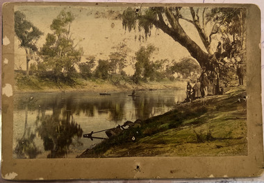
Photograph - Wurundjeri People at Studley Park
... The Wurundjeri Woi Wurrung People were the original owners... The Wurundjeri Woi Wurrung People were the original owners of the land ...The Wurundjeri Woi Wurrung People were the original owners of the land on which the City of Boroondara is now located. They made active use of the Yarra for food and transport [an original canoe is held in the collection of the Melbourne Museum]. From 1863, members of the Wurundjeri Woi Wurrung were resettled at the Corranderrk Aboriginal reserve at Healesville. The [now] best known member of the Wurundjeri People was William Barak, who may be pictured here.If the attribution in the annotation is correct, then this may be the earliest photograph of members of the Wurundjeri People at Kew. The photo may be unique.Hand tinted photograph on mounting card of members of the Wurundjeri Woi Wurrung on the banks of the River Yarra, allegedly at Studley Park before 1855 [according to the annotation on the reverse] The photograph of the river and its near and far banks includes two boats on the river, a row boat and a canoe, and people standing on the near bank or seated on the branch of a tree. In addition to men and women of the Wurundjeri People, there appears to be two Europeans pictured, one wearing a hat and the other standing at right. Annotations on the reverse identify a [possible] location and date. [Size: Mount 140 x 215mm | Photograph 125 x 190mm]Various hands and dates: "Original lead pencil lettering Studley Yarra Yarra / Yarra Yarra Studley / Studley (Park?) / Note aboriginals in a bark canoe / Prior 1855 / Very early photo Yarra River originally known as the Yarra Yarra / [illegible part word in ink]".wurundjeri woi wurrung, yarra river, aboriginal and torres straight islander