Showing 420 items
matching localities
-
 Bacchus Marsh & District Historical Society
Map, Bullengarook Estate Property Sale. 1911
Bullengarook is a locality located 19 kilometers north of Bacchus Marsh. Pastoral leases for European colonists were granted to people for this area from around the 1840s.The Bullengarook Estate was part of these early pastoral holdings. By the 1900s the property had been owned by the Skene family for a number of years. In early 1911 the property then consisting of 300 acres and the homestead upon it was offered for sale in one lot. It appears however that the sale of the property did not go through in 1911. It was later leased by Thomas Skene to a Mr Coutts in 1915 and ultimately and at a later stage the property was sold by the Skene family.A single page paper map showing land allotments for sale from the Bullengarook Estate. The map is pasted into a bound volume containing 76 maps or plans in total. High resolution digital image stored on BMDHS computer network. land sales bacchus marsh, bullengarook land sales, bullengarook estate, bullengarook vic history -
 Bendigo Historical Society Inc.
Document - GREAT SOUTHERN MINE - NOTES ON THE GREAT SOUTHERN MINE
One copy of hand written and one copy of typed notes on the Great Southern Mine. Notes include Size of lease, Depth, Locality, Plant, Early History and Best Gold. Note on underground connection between the Great Southern 941 feet level to Ulster United 893 feet level. Reference: Mines Dept Special Edition Australian Mining Standard 1.6.1899, Mines Dept Booklet Bendigo Goldfield Geo Brown 1936, Mines Dept Quarterly and Annual Reports, Annals of Bendigo 1878 to 1915 Mining Sections, A Richardson, Catalogue Mining Sales J H Curnow 10.4.1947.mine, gold, great southern mine, great southern mine, garden gully line of reef, ulster united, mines dept special edition australian mining standard 1.6.1899, mines dept booklet bendigo goldfield geo brown 1936, mines dept quarterly and annual reports, annals of bendigo 1878 to 1915 mining sections, a richardson, catalogue mining sales j h curnow 10.4.1947 -
 Kew Historical Society Inc
Plan - Subdivision Plan, Summerhill Estate, 1920-1940
Pru Sanderson, in her groundbreaking ‘City of Kew Urban Conservation Study : Volume 2 - Development History’ (1988), summarised the periods of urban development and subdivisions of land in Kew. The periods that she identified included 1845-1880, 1880-1893, 1893-1921, 1921-1933, 1933-1943, and Post-War Development. These periods were selected as they represented periods of rapid growth or decline in urban development. An obvious starting point for Sanderson’s groupings involved population growth and the associated economic cycles. These cycles also highlighted urban expansion onto land that was predominantly rural, although in other cases it represented the decline and breakup of large estates. A number of the plans in the Kew Historical Society’s collection can also be found in other collections, such as those of the State Library of Victoria and the Boroondara Library Service. A number are however unique to the collection.The Kew Historical Society collection includes almost 100 subdivision plans pertaining to suburbs of the City of Melbourne. Most of these are of Kew, Kew East or Studley Park, although a smaller number are plans of Camberwell, Deepdene, Balwyn and Hawthorn. It is believed that the majority of the plans were gifted to the Society by persons connected with the real estate firm - J. R. Mathers and McMillan, 136 Cotham Road, Kew. The Plans in the collection are rarely in pristine form, being working plans on which the agent would write notes and record lots sold and the prices of these. The subdivision plans are historically significant examples of the growth of urban Melbourne from the beginning of the 20th Century up until the 1980s. A number of the plans are double-sided and often include a photograph on the reverse. A number of the latter are by noted photographers such as J.E. Barnes.The Summerhill Estate was a subdivision in Glen Iris of 24 ‘choice allotments’. The lots were primarily on both sides of Dillon Grove. Other lots at each end of the subdivision faced Margaret Street and Summerhill Road. It was from the latter that the subdivision took its advertised title. The lots were originally advertised for £10 deposit with 20 subsequent payments over five years. Pencilled on the printed plan is a change to the deposit required; a reduction to 20/-. Annotations indicate that the new deposits ranged from 30/- to 45/-. The most expensive lots faced Summerhill Road. This subdivision plan is unusual in that the front and rear of the card are for subdivisions in different localities.subdivision plans - glen iris, summerhill estate -
 Eltham District Historical Society Inc
Photograph, 1934 Floods at Eltham
Published in the Diamond Creek Basin Study, 1980 and identified at Diamond Creek, locality not identified, 1934. The location is actually looking south across the Diamond Creek towards Falkiner Street, beside the Main Road bridge at Eltham South from what is now part of Wingrove Park opposite Antoinette Boulevard. The bridge railing is just visible to the left of image. The large leaning Manna Gum beside the bridge still stands in 2021 alongside the Diamond Creek trail. In 1934 extensive flooding of the Yarra River and Diamond Creek set new records for flood plain level (Eltham Chronology, EDHS)Black and white photographCopied by Hugh Fisher, Photographer, 6 York Street Eltham A1678B Floods- Eltham - 1934floods, yarra river, eltham, flooding, diamond creek, flood -
 Vision Australia
Map - Object, Victorian railways map
A black and white map of Victoria showing the railway lines where mail is transported and the individual towns listed next to the dot that provides location of such. Underneath is written "Map of Victoria showing the localities beyond the suburbs of Melbourne to which library books are sent to blind members. Books are carried over the railways FREE there is no charge to the readers." Through the work of Tilly Aston, braille postage was provided free by the Victorian Railways which greatly assisted the Braille Library in reaching members who resided outside of Melbourne. This map was produced to show the extent of the work by the Victorian Association of Braille Writers and the need for reading materials across the state.Paper of Victorian railway lines mounted in framevictorian association of braille writers, marketing -
 Bendigo Historical Society Inc.
Photograph - GREAT EXTENDED HUSTLERS MINE
black and white postcard. Great extended Hustlers poppet head, now at Wattle Gully, Chewton ( J. Lerk 26.22.1999 ) Poppet head in front of mining buildings, stacks of sawn timber to right. Written on back ' Royal Historical Society of Victoria Bendigo Branch, printed across top. Great Extended Hustlers/locality/ Hustlers Hill, Nth. Bendigo/Formed 1865/Last production 1921/Depth of Shaft 3470 feet/Poppet Legs - Steel, 70 feet high. /Winding Engine: First motion 8 ft. drums/Gold Very Rich/Total Yield - 300,000 ozs. / Dividends $675,000. 'Post Card' printed on RH side.organization, business, great extended hustlers mine -
 Bendigo Historical Society Inc.
Document - CARLISLE UNITED MINE GARDEN GULLY LINE
4 hand written foolscap pages of information about the Carlisle United Mine. Information such as area of lease, depth, locality, early history, plant & equipment, gold obtained and dividends. Also some information on the Kent Shaft. The Carlisle United was formed by the amalgamation of three companies, the Old Carlisle, the North Garden and the Passby. Also mentioned are: the Golden Fleece, Central Garden Gully, Garden Gully United and its Tribute Companies, the Constellation, Specimen Hill Mine, Kocks Pioneer, Bendigo Amalgamated Mines, the Pandora Reef, the Unity Reef, Guilford Plateau and the Nell Gwynne Reefs Mine. Also 2 typed copies of notes on foolscap paper.place, mining site, carlisle united mine, carlisle united mine, kent shaft, old carlisle, north garden, passby, mr j b watson, golden fleece, central garden gully, garden gully united, tribute companies, constellation, bendigo amalgamated mines, specimen hill mine, kocks pioneer, pandora reef, unity reef, guilford plateau, nell gwynne reefs mine -
 Kew Historical Society Inc
Photograph - 29 Uvadale Grove, Kew, 1920
The numerous subdivision plans in the Kew Historical Society's collection represent working documents, ranging from the initial sketches made in planning a subdivision to printed plans on which auctioneers or agents listed the prices for which individual lots were sold. In a number of cases, the reverse of a subdivision plan in the collection includes a photograph of a house that was also for sale by the agent. Subdivision plans are historically important documents used as evidence of the growth of suburbs in Australia. They frequently provide information about when the land was sold on which a built structure was subsequently constructed as well as evidence relating to surveyors and real estate and financial agents. These photographs provide significant heritage information relating house design and decoration, fencing and household gardens.When 29 Uvadale Grove, Kew was offered for sale it was described as: ‘Kew. Fine locality, 3 minutes Cotham Road. Splendidly built 6 roomed Brick Villa. Rooms 17 x 14, 16 x 13, &c. Beautifully fitted throughout. Land 70 x 134 to ROW.’ The price was advertised as being £1,400. The house exhibits key features of Federation architecture such as the gabled roof with a facing of half-timber and stucco. The veranda has a curved corrugated iron roof supported by timber pillars and fretwork. The slate roof with terra cotta ridging and finials marks a transition to the more common use of Marseilles tiles in Federation architecture.subdivisions - kew (vic.), 29 uvadale grove - kew (vic.) -
 Ballarat Heritage Services
Photograph - Colour, The Bear Hotel, Devizes, England
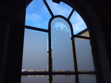
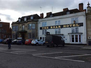
Devizes is a medieval market town in the centre of Wiltshire, 16 miles from Stonehenge and 8 miles from Avebury. The building of a castle in Norman times dictated the layout of the town which is still visible. It contains over 50 Heritage Plaques. There were people in Devizes locality in prehistoric times and a Roman villa once stood on The green. The Wiltshire Museum is home to one of the best Broze Age collections in Britain and includes finds from around Stonehenge including the famous Bush Barrow gold. Some convicts that were tried at the Devizes Assizes were transported to Australia. Amongst these was John Chew, transported to Tasmania, but later his family settled in Victoria.devizes, the bear hotel, staircase, window -
 Ballarat Heritage Services
Photograph - Colour, The Bear Hotel, Devizes, England
Devizes is a medieval market town in the centre of Wiltshire, 16 miles from Stonehenge and 8 miles from Avebury. The building of a castle in Norman times dictated the layout of the town which is still visible. It contains over 50 Heritage Plaques. There were people in Devizes locality in prehistoric times and a Roman villa once stood on The green. The Wiltshire Museum is home to one of the best Bronze Age collections in Britain and includes finds from around Stonehenge including the famous Bush Barrow gold. Some convicts that were tried at the Devizes Assizes were transported to Australia. Amongst these was John Chew, transported to Tasmania, but later his family settled in Victoria.devizes, the bear hotel, staircase, window -
 Ballarat Heritage Services
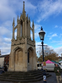
Photograph - Colour, Dorothy Wickham, Monument in Town Square, Devizes, England, 2017
Devizes is a medieval market town in the centre of Wiltshire, 16 miles from Stonehenge and 8 miles from Avebury. The building of a castle in Norman times dictated the layout of the town which is still visible. It contains over 50 Heritage Plaques. There were people in Devizes locality in prehistoric times and a Roman villa once stood on The green. The Wiltshire Museum is home to one of the best Bronze Age collections in Britain and includes finds from around Stonehenge including the famous Bush Barrow gold. Some convicts that were tried at the Devizes Assizes were transported to Australia. Amongst these was John Chew, transported to Tasmania, but later his family settled in Victoria.devizes, bear hotel, staircase, window -
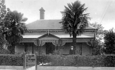 Surrey Hills Historical Society Collection
Photograph, Richard Bate at his home 'Camelford', 7 Norris Street, Surrey Hills (demolished)
Richard Bate built ‘Avondale’ at 176 Union Road in 1883 as a display home for subdividers of the Windsor Park Estate auction in that year. Richard built many homes in the locality – probably including No.101 Guildford Road, almost identical to his home. Richard also built the Box Hill Shire Hall in the 1880s (replaced in 1934 by the Box Hill Town Hall). Richard junior and family retained this house until the 1950s. Occupied in 2000 by Julie Ellis. In May 2000 Richard's grandson Jack Bate and great-grandsons Alan and Geoff (all of whom are builders) visited 7 Norris Street and lent this photo for copying. Demolished after subsequent sale. A black and white photograph of a Federation/Edwardian style timber house with detailed lacework around the veranda. There is a man standing on the right side of the photo. He is wearing a hat and is sporting a long white beard.norris street, surrey hills, house names, avondale, camelford, windsor park estate, box hill shire hall, builders, federation style, edwardian style, richard bate -
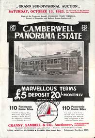 Melbourne Tram Museum
Ephemera - Real estate sale, Cranny Sambell & Co, "Camberwell Panorama Estate", Oct. 1923
Pamphlet advertising the sale of land at the "Camberwell Panorama Estate" - Doncaster and Bulleen Road 13-10-1923. Gives terms of sale, photos showing the views and a nearby shopping centre. Has a large photo of MMTB No. 20 on the front cover. The tramcar is of the Hawthorn Tramways Trust four-door bogie type. MMTB No 20 was an ex-Prahran and Malvern single trucker or small tram A class. Gives details of the 110 lots to be sold, terms, location, and that the tram was proposed to be extended to the corner. This extension took place in 1937. The locality plan shows proposed plans for tram lines in Belmore Road and Burke Road north of Whitehorse Road. Demonstrates the style of land sale pamphlet including the availability of tram services to prospective purchasers.Pamphlet - folded - printed in two colours of cream coloured paper with photographs and plans.has pencil notes on the top of the front page.sale of land, trams, real estate, camberwell panorama estate, east camberwell, doncaster road, bulleen road, tram 20 -
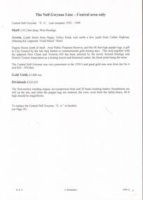 Bendigo Historical Society Inc.
Document - CENTRAL NELL GWYNNE - NOTES ON CENTRAL NELL GWYNNE
Handwritten notes and carbon copy on the Central Nell Gwynne Mine. Notes mention the depth of shaft, locality, gold yield and dividends. Also mentioned is the area selected by the Bendigo and District Tourist Association as a mining tourist and historical Centre. Also mentioned is the Hercules no 1, Pearl East, Hercules New Chum and the Carlisle. Also in the notes are alterations for a proposed booklet. It mentions Collman & Tacchi, Great Extended Hustlers, Lazarus, Barnet Lazarus, United Devonshire, West United Devonshire, Confidence Extended, Johnson's No 2, New Argus, South New Moon, Lansell's Comet and the Central Red, White and Blue. Images 3509.13a,13b,13c,13d,13e,13f,13g,13hdocument, gold, central nell gwynne, central nell gwynne, notes on central nell gwynne, bendigo and district tourist association, jack barker, hercules no 1, pearl east, hercules new chum, carlisle, collman & tacchi, great extended hustlers, lazarus, barnet lazarus, united devonshire, west united devonshire, confidence extended, johnson's no 2, new argus, south new moon, lansell's comet, central red, white and blue, baling of water -
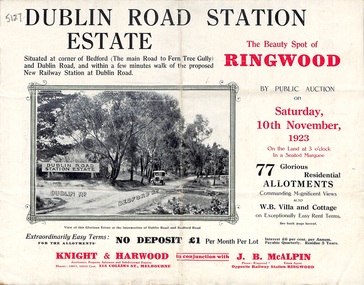 Ringwood and District Historical Society
Pamphlet, Land Sale Brochure, Dublin Road Station Estate - 1923
"Extracts from Recent Daily Newspaper - Ringwood Train Service - STATION WANTED AT RINGWOOD EAST. A deputation from the Ringwood East Railway League and Progress Association waited on the chairman of the Railway Commissioners yesterday afternoon and asked that a railway station be erected at Dublin-road, a mile and a quarter from Ringwood. The deputation urged that there were 81 passengers who, if the station were provided, would make daily use of it, and that as the Commissioners had purchased a site for a station at Dublin-road it was evident they had at one time considered it the most suitable site. The Chairman of Commissioners stated that the estimated cost of the station was £3700. Land owners in the locality should pay a proportion of the cost. Members of the deputation replied that there would be no difficulty in raising the money."Multi-fold brochure advertising public auction of residential allotments on Saturday, 10th November, 1923. Brochure includes subdivision features, local facilities and photographic images of the area and details of proposed new railway station at Dublin Road.Subdivision plan includes Dublin Road, Alexandra Road, Vonadawn Avenue, Green Street, Howard Avenue, Wood Street, and Bedford Road (Main Ferntree Gully Road). Auctioneer - Knight & Harwood, 315 Collins Street, Melbourne, Phones Central 10615, 10616. Agent - J.B. McAlpin, Opposite Railway Station, Ringwood, Phone Ringwood 7. -
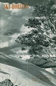 Falls Creek Historical Society
Journal - Ski-Horizon Vol. 2 No 11
Ski-Horizon is the official journal of the Federation of Victorian Ski Clubs which began publication in 1949. The were 26 original member clubs which included Albury Ski Club, Bogong Ski Club, Myrtleford Ski Club, Tallangatta and District Ski Club and Wangaratta Ski Club. Two pioneers of Falls Creek, Tom Mitchell, M.L.A., and Martin Romuld were Vice-Presidents of the Federation.This Journal is significant because it documents the early development of skiing in Victoria.The journal features stories and events chronicling developments in Victoria and internationally. Items related to the Falls Creek Area in this publication include:- Page 2: Reference to ski instructors and Ski Schools in Victoria including Bob Hymans' School and Ernst and Auriel Forras who operate the Nussen School with Max Denham. Page 5 Bogong High Plains locality map, with construction areas and power lines marked. It is accompanied by a notice regarding safety and access from H. H. C.Williams, Construction Engineer. Page 12 An article referring to Tom Mitchell's stallion "Debtor" and Ernest Forras, Ski Instructor. Page 13: Continuation of Ernest Forras' profile. Page 22 Comment by Toni St. Elmo and the Myrtleford Ski Club Tow. ski history victoria, federation of victorian ski clubs, ernest forras, nissen ski school -
 Melbourne Tram Museum
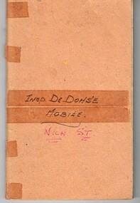
Document - Notebook, Harold De Dohse, Inspector Harold De Dohse reports, 1956 to 1959
Notebook - 100 ruled blue line pages centre stapled with card cover used by Inspector Harold De Dohse to record his observations and instructions to crews regarding uniforms, behaviour, operations, accidents and other offences. Has been ruled into 8 vertical columns to record "date, time, route, locality, conductor or driver, number, nature of Offence and action taken" Commences 1/12/1956 through to 3/5/1959. Has various date stamps in the book - the purpose may have to be to show that they have been recorded by the Board clerical traffic staff. See htd1205note.pdf for information about the purpose of the book and its use, including industrial and training issues - from Kevin Stanes 24-4-2017.On front cover in blue ink "Insp De Dohse Mobile" and in red ink "Nich St"trams, tramways, mmtb, uniforms, officers, inspectors, drivers, conductors, derailments, personnel, notebooks -
 Federation University Art Collection
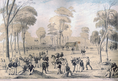
Print - Printmaking - Lithograph, Tulloch, David, 'Great Meeting of Gold Diggers Dec 15th 1851' by Thomas Ham, 1852
One of the first large goldfield meetings was at Castlemaine in 1851. After the extraordinary success of the Mt Alexander Diggings the Government issued a proclamation, raising the licence fee from thirty shillings to three pounds. As soon as these intentions became known a public meeting of miners was held. For miles around work ceased, with diggers travelling as far as Bendigo to attend the meeting. It is estimated that around 18,000 people attended the meeting. The notes with the engraving state The trees in this locality are chiefly Stringybark; some of them are peeled of their covering, as many persons prefer erecting bark huts to living in a comfortless tent. The various groups, and costumes of the men, are characteristic of our gold digging community. This item is part of the Federation University Art Collection. The Art Collection features over 2000 works and was listed as a 'Ballarat Treasure' in 2007.Colour lithograph of a meeting of diggers at a meeting in Mt Alexander. The meeting was the result of goldfields agitations against the license fee. lower centre "Great Meeting of Gold Diggers Dec 15th 1851" lower left side "Drawn By D. Tulloch" lower right side "Engraved by Thomas Ham"art, artwork, ham, thomas ham, tulloch, castlemaine, goldfields agitation, printmaking, edition, coloured lithograph, david tulloch, gold pan, shovel, wheelbarrow, waggon, bark hut, ring barked tree, gold mining -
 Warrnambool and District Historical Society Inc.
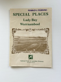
Pamphlet - Special Places Lady Bay Warrnambool, Philprint Warrnambool, 1989
This pamphlet was produced for the Warrnambool Branch of the National Trust of Australia (Victoria) for Heritage Week, April 16-23, 1989 and contains information written by Warrnambool residents about their locality. This was a co-operative venture by people with a common interest in protecting the natural environment near their home. Areas covered in the written information include: Formation of the Coast, Archaeological survey, Gunditjmara History, vegetation, history and recreational uses of the Lady Bay area. The map shows special places of interest including past and present navigational aids, sites of shipwrecks and other historical places of interest. The Warrnambool Branch of the National Trust was originally formed in March 1969 and merged with the Port Fairy Branch in late 1970. In October 1979, the Warrnambool Branch was reformed and operated into the late 1990's. This is an example of a publication produced by the Warrnambool Branch of the National Trust Australia (Victoria). It provides historical information and perspectives of the recreational uses in and around Lady Bay Warrnambool.An A2 piece of buff coloured thick paper folded into eight to make an A5 pamphlet. The front cover has green printing with the National Trust symbol of three eucalyptus leaves in green. There is a brown sepia photograph showing a view across Lady Bay with the suspension bridge across the Merri River in the foreground, Viaduct Road in the middle ground and the breakwater in the background. There is a purple inked stamp on the top right hand corner. The rear cover has brown writing and includes logos of bodies who assisted with the publication. There is a brown line drawing of the viaduct and pier at the Warrnambool Breakwater. The inside of the unfolded pamphlet contains a map of Lady Bay and adjacent area showing places of interest and shipwrecks marked in red circlesFront cover: Special Places Lady Bay Warrnambool National Trust of Australia (Victoria) Warrnambool Branch Ronald J. Cummingwarrnambool, lady bay warrnambool, national trust australia victoria warrnambool branch, heritage week 1989, lady bay shipwrecks -
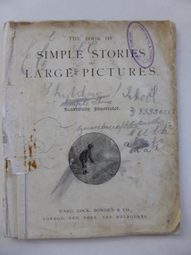 Warrnambool and District Historical Society Inc.
Book, Simple stories & large pictures, Late 19th century
This book was given as a prize to William Giles in the late 19th century. It came from the Skiddaw Sunday (or Sabbath) School. Skiddaw was the home of the Batterbee family and was situated on the old Princes Highway in East Warrnambool near Simpson Street today. The corner here was known as ‘Batterbees Corner’ and there is a Skiddaw Street in the locality today. George Batterbee had a ham and bacon business in Warrnambool. For 36 years his wife, Mary, conducted a Sunday School at Skiddaw (from 1882 to 1918). This Sunday School was under the auspices of St. John’s Presbyterian Church in Warrnambool. Mrs Batterbee was assisted by her daughter Florinda and other teachers. Florinda and her brother Rex were both artists of note. William Giles and his family lived on the Allansford Road. The Logan family farm was in the vicinity of where Logans Beach is today. This book, though tattered and stained, is most important as the only item we have in our collection that is associated with the Skiddaw Sunday School. Situated in a family home, this Presbyterian-sponsored Sunday School operated for 36 years under the direction of Mary Batterbee. This is a book of 32 pages with the cover and perhaps some of the pages missing. It has been stapled but the staples have been removed. The book has large print and illustrations on all the pages. The illustrations have been coloured in by hand. The first page is loose and scribbled on. The pages are very stained and torn in places. The inscription is handwritten in black ink. ‘Skiddaw S. School, Second Prize, Awarded to William Giles for diligence in class, S. Logan, Teacher’. skiddaw, east warrnambool, batterbee family, giles family, logan family, history of warrnambool -
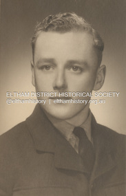 Eltham District Historical Society Inc
Photograph, Peter Fox, Leslie Ernest Shillinglaw, c.1943
Leslie Ernest Shillinglaw was born at Dalmore, Victoria in 1925, the son of Samuel Ernest Shillinglaw and Anna Lucy (Barlow). He was Phillip and Sarah Shillinglaw's grandson. Following his service in the RAAF during World War Two, Leslie married Alva Elizabeth Thomas in 1949. He died in 2007. World War Two Service Veteran Details Name SHILLINGLAW, LESLIE ERNEST Service Royal Australian Air Force Service Number 144902 Date of Birth 03 Aug 1925 Place of Birth DALMORE, VIC Date of Enlistment 30 Sep 1943 Locality on Enlistment HEALESVILLE, VIC Place of Enlistment MELBOURNE, VIC Next of Kin SHILLINGLAW, ERNEST Date of Discharge 01 Apr 1946 Rank Leading Aircraftman Posting at Discharge 36 SQUADRON Prisoner of War No Honours None for displaymarg ball collection, 1943, leslie ernest shillinglaw, second word war, r.a.a.f. -
Glen Eira Historical Society
Article - PRENTICE STREET, 47, ELSTERNWICK
Three sets of real estate campaigns for this property: 1/Property Review Weekly newspaper article date 13/12/2002 includes one coloured photograph. The article gives details of renovations done ten years previously and modern features for efficient energy. Also notes suburban locality features. 2/Newspaper article 03/02/2003 gives brief detail on home features both this and above include similar coloured photograph. 3/Newspaper article dated March 2009 gives detail on home features and garden amenities. 4/Real estage agent A4 flyer plus small newspaper ad (Domain 19/04/2013) for auction of 11/05/2013. Included are 2 colour exterior (front and rear) plus 2 colour interior photos for this Edwardian home.prentice street, elsternwick, peer gary, estate agents, timber houses, stefanis angelos, stavrakis bill, kelly juanita, bigginscott, edwardian style -
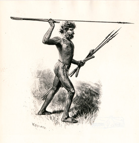 Eltham District Historical Society Inc
Photograph, Sketch of Aboriginal man with spears by W. Macleod
This black and white image appears on page 9 "Painters and Pioneers: One hundred years of Eltham and its Shire" by Alan Marshall (1971). (It is incorrectly acknowledged as S.T. Gill in the acknowledgements). It relates to Chapter 1 "The Beginning" and the description of explorer's Joseph Gellibrand journey through the area (and beyond) of the area now known as Eltham and wider Shire of Nillumbik. Gellibrand was accompanied by male aborigines. William Macleod (1850-1929) was a contributor to the "Picturesque Atlas of Australia" 1886. Described in "The Daily Telegraph" 21 June 1924 :"Macleod is a preserver of the scenic records of his own time, inasmuch as he has furnished posterity with many view of towns, rivers, and other localities, as they appeared in the years 1886-8. Among these, he has given us ...a blackfellow throwing a spear...' Image first published 1886. Image re-published in "Painters and Pioneers", 1971 pioneers and painters, aborigine, spear, drawing, william macleod, picturesque atlas of australia, aboriginal australian -
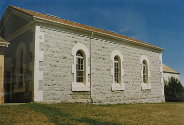 Federation University Historical Collection
Photograph - Photograph - Colour, Mount Pleasant Wesleyan Chapel,1989, 27/02/1989
"Cornish immigration in Ballarat tended to group together as they did in Cornish communities around Victoria. The area known as Cornishtown in Ballarat in the 1850s was settled by quiet, religions Cornish Diggers who named the rise on which they pitched their tents, Pleasant Mont. This soon became known as Mount Pleasant, and the locality continued to attract cornish immigrants who built their homes around the Wesleyan Church. This had begun as a small tent chapel where the cornish diggers could worship in the peaceful quiet offered by the mont. As compatriots continued to expand their community, a larger and more subsyantial edifice was required. This plain box like building reflected its Cornish origins in its unpretentious appearance. This building still stands in the shadow of a more recent stucture." (Ballarat's Irish Folk by Ann Colman) Samson Keast and Elizabeth Jane Forror Pascoe married at this church on Christmas day 1865. Colour photograph of a bluestone church with three arched windows down one side.mount pleasant, mount pleasant wesleyan church, pleasant mont, samson keast, elizabeth pascoe, cornish, mt pleasant -
 Ballarat Heritage Services
Photograph - Photograph - Colour, Clare Gervasoni, Tarilta, 2017, 16/07/2017
Tarilta is a rural locality and former gold-mining town 12 km south of Castlemaine, 4 km north-west of Guildford and 3 km north-east of Vaughan. The last gold mining activity took place around the 1880s. It was originally Kangaroo Flat, being located where the Kangaroo Creek enters the Loddon River. It was surveyed and named in 1864. Gold was discovered at Tarilta in 1853. The Tarilta School was opened in 1860 in a Wesleyan chapel, and closed i n1925. In 1864 a township was surveyed and named Tarilta, the word being derived from an Aboriginal expression thought to mean kangaroo. In 1865 Bailliere’s Victorian gazetteer described Tarilta as being an alluvial and quartz gold-mining town with three quartz-crushing mills, three horse-puddling machines and two hotels. The elevated nature of the land around Tarilta made it accessible only by horse and dray, or on horseback. Colour photograph of Tarilta in Central Victoria. tarilta, central victoria, landcape -
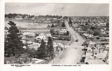 Ballarat Tramway Museum
Postcard, Rose Stereograph Co, "Panorama at Ballarat East Vic", c1916
Photo looks west from the Ballarat Fire Station (East) tower, and has a good view looking along Barkly St. Shows the crossing loop between Eastwood and Main St with one tram in the view. Wal has dated the photo as 1914 in his album notes. On rear Wal Jack has written "Looking up Barkly St towards Mt Pleasant. Photo taken from Ballarat Fire Station about 1914-1916 period. Old type tram from Mt Pleasant about to turn into Main St. Note old passing loop behind tram. Loop removed to top of rise in centre background. Old Ballarat East Gardens on left and council yards, showing big tin shed in centre of picture. Locality much altered today." See item 5127 for a digital image.Yields information about the buildings and scene looking west from the Fire Station tower along Barkly St. East BallaratPostcard Black and white - Rose Series No P4614, Divided back. No publishers details on rear.See image 2 for Wal Jack's notes.tramways, trams, esco, ballarat east, barkly st -
 Otway Districts Historical Society
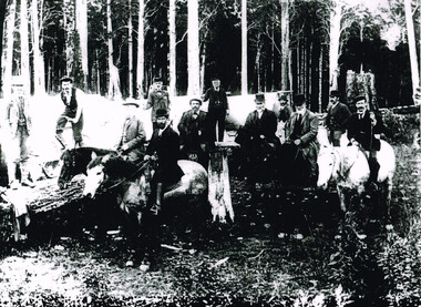
Photograph, Railway Survey Camp, Beech Forest, 4 Apr 1897, 4 April 1897
On the 18th August, 1896, the question of selecting localities for the permanent survey of a narrow-gauge line to Beech Forest from Colac was mooted. Two potential lines were examined. In a memorandum to the Minister for Railways, dated 23rd March, 1897, the Engineer-in-Chief recommended that the eastern and longer route via Lardner's Track be adopted. The second route, while identical from Colac to Gellibrand River, differed. By a more direct route the Beech Forest terminus is reached 5 miles sooner and cost approximately L24,500 less. The direct line would also serve a larger lot of settlers and would obtain a larger lot of traffic than the alternate proposal. The Parlimentary Standing Committee on Railways examined the proposal in situ and recommended that the direct route from Gellibrand to Beech Forest should be adopted and the Lardner's Track route should be abandoned at once.Photograph, Railway Survey Camp, 4 April 1897. Inspection of alternative routes by Parliamentary Committee on Railways.People named in the photograph.beech forest; railway; survey; victorian parliament; calcutt; fraser; e.h. cameron; d. mciville; a. harris; n. mcinnes; j.s. white; j. wood; t. baker; j. gardner; t.g. watson; standing committee; -
 The Beechworth Burke Museum
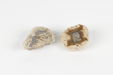
Geological specimen - Thunderegg agates, Unknown
Thunderegg Agates are formed within rhyolite volcanic ash layers. They are rough spherical shapes, varying in size from less than an inch to over a metre long. Thundereggs usually contain centres of chalcedony which may have been fractured followed by deposition of agate, jasper or opal, either uniquely or in combination. A unique characteristic that these specimens have is the fact that they often look like ordinary rocks on the outside, but slicing them in half and polishing them may reveal intricate patterns and colours. These particular specimens are examples of thunderegg agates. Agate is a variety of chalcedony, a cryptocrystalline form of quartz. The agate component contributes to the intriguing internal patterns of the specimens. The specific locality of these specimens is unknown but they can be found in flows of rhyolite lava. They are formed in gas pockets in the lava, which act as moulds. These specimens can be found globally, with specific locations in Germany being particularly abundant. This specimen is part of a larger collection of geological and mineral specimens collected from around Australia (and some parts of the world) and donated to the Burke Museum between 1868-1880. A large percentage of these specimens were collected in Victoria as part of the Geological Survey of Victoria that begun in 1852 (in response to the Gold Rush) to study and map the geology of Victoria. Collecting geological specimens was an important part of mapping and understanding the scientific makeup of the earth. Many of these specimens were sent to research and collecting organisations across Australia, including the Burke Museum, to educate and encourage further study.Two small solid specimens with pale, sandy-coloured exteriors and fractured internal patterns. burke museum, beechworth, geological, geological specimen, thundereggs, thundereggs agate, agate, rhyolite, rhyolite lava, volcanic ash, chalcedony, cryptocrystalline -
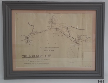 Flagstaff Hill Maritime Museum and Village
Document - Location Chart, The Mahogany Ship, 2007
This chart shows a possible site for the fabled wreck called the 'Mahogany Ship'. Flagstaff Hill’s collection includes other objects that some say could be relics from this Ancient Wreck, (also called the Gold Ship, or the Ancient Vessel). The chart shows the coordinates for the Summits of Griffith Island and of Middle Island. It also has the depths of the sea at various intervals and shows the shore and sand dunes, lighthouses and other reference points. The mystery of the Mahogany Ship began in 1836 when two shipwrecked sealers discovered the remains of an “ancient vessel” in the sand dunes about four miles west of Warrnambool. Since the last recorded sightings in the 1880’s the true origin of the Mahogany Ship has remained one of Australia’s most famous historical mysteries or fables. One of the more recent theories is that the vessel was one of the Portuguese ships exploring the Australian coast in 1522. For over one hundred years searchers have attempted to locate and identify the wreck. The search continues for the tangible evidence which will once and for all establish the Mahogany Ship’s place in Australia’s History.The chart represents the worldwide interest in locating the wreck of the Mahogany Ship. Locating the actual wreck or proving the existence of a Portuguese ship's wreck could change the history of the discovery of Australia. A Mahogany Ship committee was formed to gather and research information about the discovery of the wrecked ship. A large amount of money was offered as a prize for finding the wreck or parts of it. People have written books, painted images, made videos and told tales of the ship but it continues to remain a mystery or even a fable. The chart is significant for its possible link to one of Victoria’s and Australia’s maritime mysteries, the Mahogany Ship (also known as the Ancient Wreck). It is one of very few known relics that could give evidence of the existence and history of the vessel. It is listed on the Victorian Heritage Register S438 as it is one of Victoria’s oldest recorded shipwrecks. The identity of the vessel has the potential to change Australia’s history.A chart in a wooden frame, behind glass. The chart shows the approximate position of the mystery Ancient Wreck, later called the "Mahogany Ship". The chart is a copy and is based on the Admiralty Chart by Lieut. Stanley, dated 1872. Lower left: "THE MAHOGANY SHIP" "LOCALITY PLAN, ENLARGED FROM LIEUT. STANLEY'S ADMIRALTY CHART 1872" "APPROXIMATE POSITION OF WRECK MARKED [symbol of a Portuguese cross]" Other labels on chart: "BELFAST" "PORT FIARY" "GRIFFITHS I" "RIVER MOYNE" "RIVER MERRI" "ARMSTRONG BAY" " GORMANS LANE" "TOWER HILL" "KOROIT" "HELEN ROCK" "WARRNAMBOOL" "LADY BAY" "MIDDLE I" "LIGHT HO." Lower right: "G 410 B" Label on the back; "This chart presented to the Mahogany Ship Committee and Flagstaff Hill by Avis Quarrell, April 2007"warrnambool, shipwrecked coast, flagstaff hill maritime museum, shipwreck coast, mahogany ship, ancient vessel, ancient wreck, portuguese ship, coastal reserve, fabled wreck, gold ship, griffiths island, belfast (now port fairy), koroit, location plan, leuit. stanley, admiralty chart 1872, tower hill, merri river, moyne river, middle island, helen rock, armstrong bay, griffiths land