Showing 695 items matching "location map"
-
 Bright & District Historical Society operating the Bright Museum
Bowl
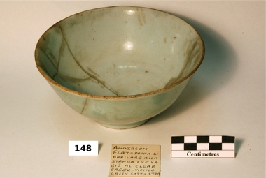
... Aldo Gios recorded the location of where most pieces in his collection were found. Some maps drawn by Aldo Gios, also give more detail. ...Brought to the Ovens Goldfields by Chinese men working in the area in the 19th century. Most likely made in China.Aldo Gios recorded the location of where most pieces in his collection were found. Some maps drawn by Aldo Gios, also give more detail. This detail is rare as most pieces of broken crockery were discarded and complete items were usually collected with no thought to recording the location where they were found. This object is part of one of the largest collections of Chinese ware found in the Upper Ovens area and the only one recording the location where found.Chinese porcelain food bowl, celadon.Blue Chinese writing or maker’s stamp on base.chinese, bowl, tableware, porcelain, buckland, celadon -
 Bright & District Historical Society operating the Bright Museum
Bowl
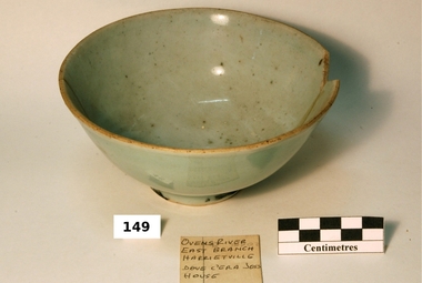
... Aldo Gios recorded the location of where most pieces in his collection were found. Some maps drawn by Aldo Gios, also give more detail. ...Brought to the Ovens Goldfields by Chinese men working in the area in the 19th century. Most likely made in China.Aldo Gios recorded the location of where most pieces in his collection were found. Some maps drawn by Aldo Gios, also give more detail. This detail is rare as most pieces of broken crockery were discarded and complete items were usually collected with no thought to recording the location where they were found. This object is part of one of the largest collections of Chinese ware found in the Upper Ovens area and the only one recording the location where found.Chinese porcelain bowl, design in glazed celadonChinese writing or maker’s stamp on base.chinese, bowl, tableware, porcelain, harrietville, celadon -
 Bright & District Historical Society operating the Bright Museum
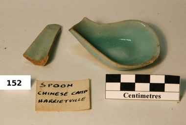
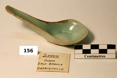
Spoon
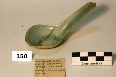
... Aldo Gios recorded the location of where most pieces in his collection were found. Some maps drawn by Aldo Gios, also give more detail. ...Brought to the Ovens Goldfields by Chinese men working in the area in the 19th century. Most likely made in China.Aldo Gios recorded the location of where most pieces in his collection were found. Some maps drawn by Aldo Gios, also give more detail. This detail is rare as most pieces of broken crockery were discarded and complete items were usually collected with no thought to recording the location where they were found. This object is part of one of the largest collections of Chinese ware found in the Upper Ovens area and the only one recording the location where found.Chinese porcelain spoon, design in glazed celadonChinese writing or maker’s stamp on base.chinese, spoon, tableware, porcelain, harrietville, celadon -
 Bright & District Historical Society operating the Bright Museum
Spoon
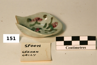
... Aldo Gios recorded the location of where most pieces in his collection were found. Some maps drawn by Aldo Gios, also give more detail. ...Brought to the Ovens Goldfields by Chinese men working in the area in the 19th century. Most likely made in China.Aldo Gios recorded the location of where most pieces in his collection were found. Some maps drawn by Aldo Gios, also give more detail. This detail is rare as most pieces of broken crockery were discarded and complete items were usually collected with no thought to recording the location where they were found. This object is part of one of the largest collections of Chinese ware found in the Upper Ovens area and the only one recording the location where found.Chinese porcelain spoon, design in glazed celadon.Celadon with green and pink flower decorations.chinese, spoon, gios, tableware, glaze, porcelain, celadon -
 Bright & District Historical Society operating the Bright Museum
Spoon
... Aldo Gios recorded the location of where most pieces in his collection were found. Some maps drawn by Aldo Gios, also give more detail. ...Brought to the Ovens Goldfields by Chinese men working in the area in the 19th century. Most likely made in China.Aldo Gios recorded the location of where most pieces in his collection were found. Some maps drawn by Aldo Gios, also give more detail. This detail is rare as most pieces of broken crockery were discarded and complete items were usually collected with no thought to recording the location where they were found. This object is part of one of the largest collections of Chinese ware found in the Upper Ovens area and the only one recording the location where found.Chinese porcelain spoon, design in glazed celadon.Chinese writing or maker’s stamp on base.chinese, spoon, gios, tableware, glaze, porcelain, harrietville, celadon -
 Bright & District Historical Society operating the Bright Museum
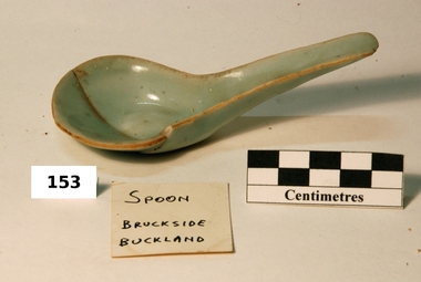
Spoon
... Aldo Gios recorded the location of where most pieces in his collection were found. Some maps drawn by Aldo Gios, also give more detail. ...Brought to the Ovens Goldfields by Chinese men working in the area in the 19th century. Most likely made in China.Aldo Gios recorded the location of where most pieces in his collection were found. Some maps drawn by Aldo Gios, also give more detail. This detail is rare as most pieces of broken crockery were discarded and complete items were usually collected with no thought to recording the location where they were found. This object is part of one of the largest collections of Chinese ware found in the Upper Ovens area and the only one recording the location where found.Chinese porcelain spoon, design in glazed celadon.Blue Chinese writing or maker’s stamp on base.chinese, spoon, gios, tableware, porcelain, celadon, glaze buckland -
 Bright & District Historical Society operating the Bright Museum
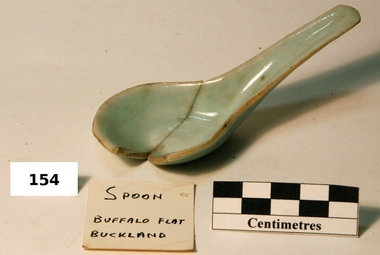
Spoon
... Aldo Gios recorded the location of where most pieces in his collection were found. Some maps drawn by Aldo Gios, also give more detail. ...Brought to the Ovens Goldfields by Chinese men working in the area in the 19th century. Most likely made in China.Aldo Gios recorded the location of where most pieces in his collection were found. Some maps drawn by Aldo Gios, also give more detail. This detail is rare as most pieces of broken crockery were discarded and complete items were usually collected with no thought to recording the location where they were found. This object is part of one of the largest collections of Chinese ware found in the Upper Ovens area and the only one recording the location where found.Chinese porcelain spoon, design in glazed celadon.Blue Chinese writing or maker’s stamp on base.chinese, spoon, gios, tableware, glaze, porcelain, buckland, celadon -
 Bright & District Historical Society operating the Bright Museum
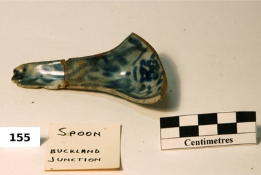
Spoon
... Aldo Gios recorded the location of where most pieces in his collection were found. Some maps drawn by Aldo Gios, also give more detail. ...Brought to the Ovens Goldfields by Chinese men working in the area in the 19th century. Most likely made in China.Aldo Gios recorded the location of where most pieces in his collection were found. Some maps drawn by Aldo Gios, also give more detail. This detail is rare as most pieces of broken crockery were discarded and complete items were usually collected with no thought to recording the location where they were found. This object is part of one of the largest collections of Chinese ware found in the Upper Ovens area and the only one recording the location where found.Chinese porcelain spoon, design in glazed celadon, with dark blue pattern.Dark blue pattern, swirls and dashes.chinese, spoon, gios, tableware, glaze, porcelain, buckland, celadon -
 Bright & District Historical Society operating the Bright Museum
Spoon
... Aldo Gios recorded the location of where most pieces in his collection were found. Some maps drawn by Aldo Gios, also give more detail. ...Brought to the Ovens Goldfields by Chinese men working in the area in the 19th century. Most likely made in China.Aldo Gios recorded the location of where most pieces in his collection were found. Some maps drawn by Aldo Gios, also give more detail. This detail is rare as most pieces of broken crockery were discarded and complete items were usually collected with no thought to recording the location where they were found. This object is part of one of the largest collections of Chinese ware found in the Upper Ovens area and the only one recording the location where found.Chinese porcelain spoon, design in glazed celadon.Blue Chinese writing or maker’s stamp on base.chinese, spoon, gios, tableware, glaze, porcelain, harrietville, celadon -
 Federation University Historical Collection
Pamphlet, The Golden Plains Art Trail
... Coloured pamphlet that folds out with a map of the locations on the Art Trail...Barker Library (top floor) Mount Helen goldfields The Golden Plains Shire Helen Lewers Dawn Whitehead Edward Coleridge-Driver Ros Lawson Arts Trail Coloured pamphlet that folds out with a map of the locations on the Art Trail The Golden Plains Art Trail Pamphlet ...Coloured pamphlet that folds out with a map of the locations on the Art Trailthe golden plains shire, helen lewers, dawn whitehead, edward coleridge-driver, ros lawson, arts trail -
 Federation University Historical Collection
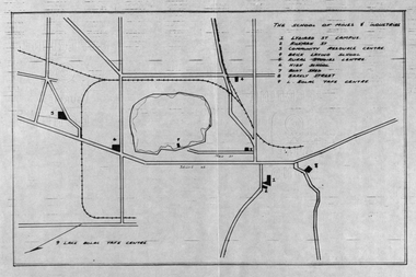
Plan, School of Mines and Industries: Location of buildings, Ballarat
... Printed map showing Ballarat School of Mines locations....Barker Library (top floor) Mount Helen goldfields Ballarat School of Mines plan ballarat lake wendouree Printed map showing Ballarat School of Mines locations. School of Mines and Industries: Location of buildings, Ballarat Plan Plan ...Printed map showing Ballarat School of Mines locations.ballarat school of mines, plan, ballarat, lake wendouree -
Federation University Historical Collection
Pamphlet, Fletcher and Son Ltd, History on Display
... Images and backgrounds histories and historical features/ Has a map of museum's location, as well as assitional information....Barker Library (top floor) Mount Helen goldfields Ballarat historical society museum Images and backgrounds histories and historical features/ Has a map of museum's location, as well as assitional information. ...Images and backgrounds histories and historical features/ Has a map of museum's location, as well as assitional information.ballarat historical society, museum -
 Wycheproof & District Historical Society Inc.
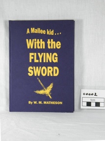
book, W.M. Matheson, A Mallee kid with the Flying Sword, 2004 (exact)
... locations are interesting. An autobiographical account of service with the Royal Auxiliary Air Force in World War II. no 601 county of london squadron royal auxiliary air force 1939 war murdoch matheson pilots foggia italy photo italian war map end of the war 1945 The Wycheproof Historical Society/With Best Wishes/Murdoch/409169 F/LT MATHESON WILLIAM MURDOCH A hard covered blue book with gold inscription. ...W.M. Matheson 409169 F/LT who lives at Wycheproof, relates his wartime experiences as a Flying Officer - William "Murdoch" Matheson made 194 operational flights and his accounts of missions and descriptions of different locations are interesting.An autobiographical account of service with the Royal Auxiliary Air Force in World War II. A hard covered blue book with gold inscription. Contents describe the author's overseas service in World War II. Two final chapters are the End of the War and Reflections. The Wycheproof Historical Society/With Best Wishes/Murdoch/409169 F/LT MATHESON WILLIAM MURDOCHno 601 county of london squadron, royal auxiliary air force, 1939 war, murdoch matheson, pilots foggia italy photo, italian war map, end of, the war 1945 -
 Wycheproof & District Historical Society Inc.
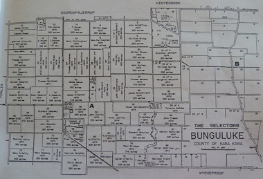
Bunguluke Map, Bunguluke District In 1923, 27.2.1923
... map of Bunguluke in the County of Kara Kara, Number L5149. Marked - Photo Lithographed by W.J. Butson 27.2.1923. The details include numbers of allotments, property owners, roads, rivers. The boundaries marked are the Parish of Jeruk, Parish of Wycheproof, Parish of Cooroopajerrup. Wycheproof township location...map of Bunguluke in the County of Kara Kara, Number L5149. Marked - Photo Lithographed by W.J. Butson 27.2.1923. The details include numbers of allotments, property owners, roads, rivers. The boundaries marked are the Parish of Jeruk, Parish of Wycheproof, Parish of Cooroopajerrup. Wycheproof township location ...By 1881 Bunguluke was a small settlement as recorded, December 5, in the Charlton "Mercury". It reports that in that year Draper's Store, Hotel and Post Office and residence at Bunguluke North was totally destroyed by fire. For years now there has been little sign of community life with houses few and far between and acreages have gone into larger holdings. The map references land blocks and owners for that era.This important map shows the local land ownership and local features that existed in 1923. This is a photocopied black and white map of Bunguluke in the County of Kara Kara, Number L5149. Marked - Photo Lithographed by W.J. Butson 27.2.1923. The details include numbers of allotments, property owners, roads, rivers. The boundaries marked are the Parish of Jeruk, Parish of Wycheproof, Parish of Cooroopajerrup. Wycheproof township location is shown with the Scale of Chains. Bunguluke maps for other years are also in the collection.map, bunguluke, jeruk, wycheproof, cooroopajerrup -
Frankston RSL Sub Branch
Map, SECRET LANDING GROUNDS AUSTRALIA
... The map is in Mercator Projection to the Equatorial Scale 1:4,000,000. The scale is statute miles. Each landing ground location is shown by a symbol indicating category and name. ...The map is in Mercator Projection to the Equatorial Scale 1:4,000,000. The scale is statute miles. Each landing ground location is shown by a symbol indicating category and name. ...Large map of aircraft landing grounds located in Australia and some nearby Islands. This map shows landing grounds in use during the latter years of World War 2. The map is in Mercator Projection to the Equatorial Scale 1:4,000,000. The scale is statute miles. Each landing ground location is shown by a symbol indicating category and name. The legend explains the landing ground categories: RAAF Main Landing Grounds, RAAF Emergency Landing Grounds, Seaplane Anchorages, Civil Main Landing Grounds, Civil Emergency Landing Grounds and Cancelled Landing Grounds. The map was revised 4th September, 1945. The map is printed on paper which is attached to a linen backing, The map is quite faded and in a fragile condition. -
 Eltham District Historical Society Inc
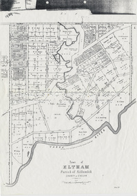
Document - Map, Victoria. Department of Crown Lands and Survey, Town of Eltham, Parish of Nillumbik, County of Evelyn, 2 October 1929
... ...Location TBD...M. Coman...Map...Wingrove k.e. dunstan Kerby Street Kirby Street Location TBD M. Coman Map michael o'shea O.B. McCutcheon P. & G. ...Township of Eltham, Parish of Nillumbik, County of Evelyn / lithographed at the Department of Lands & Survey Melbourne 5th June 1888, amended 2 October 1929 This amendment from the 1888 original shows the reserve for the the State School marked as permanent with dimensions added to Main Road and block frontages along Main Road between Mount Pleasant Road and Dalton Street and Metery Road Possibly photocopied from a copy held at PROV by Harry Gilham whilst resaerching Eltham Primary School history in 1995.a. armstrong, a. lavard, arthur c. allan, arthur c. allen, b. bowatere, baxter street, benjamin oliver wallis, bolton steet, c. souter, c.s. hain, cemetery reserve, charles brown, charles newman, charles symons wingrove, christopher caldwell, church of england, d. anderson, dalton street, david ballard, e. james, e.m. peck, edward dumaresq, eltham town, ely street, f.e. falkiner, f.m. peck, falkiner street, flint street, g. buckingham, g. drabble, george stebbing, godalmin street, h. peck, h.c.whess, h.h. farquharson, h.j. bews, henry stooke, j. goer, j. mcdonald, j. mclaren, j. roberts, j.b. knagers, james irish, jane bailey (nee matthews), john l. smith, john mason, john scott, john smith, joseph stevenson, joseph verse, k. wingrove, k.e. dunstan, kerby street, kirby street, location tbd, m. coman, map, michael o'shea, o.b. mccutcheon, p. & g. tumbull, p.k. mccaughan, p.p. cotter, porter street, pound reserve, robert hepburn, roman catholic church, s. evans, samuel dagley, samuel phillips, samuel ramsden, t. upton, t. watkins, t.a. stark, t.c.b. batt, t.p. cross, thomas grant, thornton street, w. adam, w. blain, w. long, w. watkins, w.f. ford, w.h. hull, w.r. belcher, w.t. schultz, william thomas, eltham primary school, eltham state school, eltham state school no. 209, quarry reserve -
 Eltham District Historical Society Inc
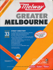
Book, Melway Publishing, Melway Greater Melbourne street directory : including Geelong, Phillip Island, Healesville, Kinglake, Gisborne, Lorne, Wallan, Bacchus Marsh Bellarine & Mornington Peninsulas; Edition 33, 2006, 2005
... Edition 33. 2006 Coloured detailed maps accessed by a street or location index. Cover: Totally revised and updated with over 1380 new street listings new maps covering Mount Duneed on the Bellarine Peninsula, Pakenham South and Rythdale. ...Eltham District Historical Society Inc 728 Main Rd Eltham melbourne Edition 33. 2006 Coloured detailed maps accessed by a street or location index. Cover: Totally revised and updated with over 1380 new street listings new maps covering Mount Duneed on the Bellarine Peninsula, Pakenham South and Rythdale. ...Edition 33. 2006 Coloured detailed maps accessed by a street or location index. Cover: Totally revised and updated with over 1380 new street listings new maps covering Mount Duneed on the Bellarine Peninsula, Pakenham South and Rythdale. Detailed public transport routes - train, tram, bus, bicycle paths & shared road routes. Eastlink fully detailed new Craigieburn bypass GPS compatible WGS/MGA Grid Special feature: New Hierachy of Roads Street directory with plastic cover, coloured maps, 902 pagesstreets,roads,melbourne,map,melway -
 Warrnambool RSL Sub Branch
Map - 1947 Minesweeping map, North Queensland minesweeping map, unknown
... 947 RAN history shows location of minefields to be cleared in 1947 and names of minesweeping ships Laminated A3 Map plus A4 map in pocket (copies of original) North Queensland minesweeping map Map 1947 Minesweeping map ...1947 an after-effect od WW2Laminated A3 Map plus A4 map in pocket (copies of original)shows location of minefields to be cleared in 1947 and names of minesweeping ships!947 ran history -
Glen Eira Historical Society
Article - OUTER CIRCLE RAILWAY
... The article includes a map of the section of the line in Caulfield. 5/A Photocopy of two images of train line locations on the Outer Circle Line. ...The article includes a map of the section of the line in Caulfield. 5/A Photocopy of two images of train line locations on the Outer Circle Line. ...This file contains five items: 1/Two copies of a document titled THE OUTER CIRCLE RAILWAY by the Royal Historical Society of Victoria and the Australian Railway Historical Society, Vic div. It details the history of the construction of the Outer Circle Railway and discussed expenses and other factors affecting the construction of the line. Notes compiled by R.K Whitehead, Research and Archives Officer Australian Railway Historical Society Victoria Division. The document includes three maps of the outer circle railway line. 2/Four newspaper articles detailing the history of the Outer Circle Railway Line. They include ten black and white images of various aspects of the railway and three line maps. The first article is titled ‘Rail Link with the Past’. In the COLLINGWOOD COURIER dated 07/10/1970, author unknown. The second article titled ‘Ghost trains of the Outer’ by Kenneth Joachim in the HERALD dated 18/04/1975. The third article is titled ‘Tracks in Time’ by Norman Thompson from NEWS, dated 13/02/1973. The fourth article is titled ‘Our Ghost Railway’ by John Townsley from the HERALD, dated 06/11/1974. 3/A letter from Victorian Railways Chief Estate Officer N.A Wigmore to the Honorary Secretary of the Caulfield Historical Society, dated 19/11/1975 regarding the leasing of land along the Outer Circle Railway Reserve from Dandenong Road to the Hughesdale Station. 4/Two copies of an article titled ‘Outer Circle Railway’ in the CAULFIELD HISTORICAL SOCIETY NEWSLETTER undated detailing the history of the outer circle line. The article includes a map of the section of the line in Caulfield. 5/A Photocopy of two images of train line locations on the Outer Circle Line. One on Warrigal Road, looking south from Ashburton dated 1936. The second is of the Black Bridge over Gardiners Creek dated 1935.outer circle railway, normanby road, caulfield station, outer circle line, rosstown junction railway, monash john, caulfield historical society, poath road, deepdene dasher, ashby dasher, dandenong road, gippsy goods, mallee root mercury, outer circle railway reserve, railway lines, railway stations, steam trains -
Glen Eira Historical Society
Article - Rosstown Railway
... Concluding with information on the location of the Trail and the expected time required to walk the entire track included in the review is a map of the Rail Trail, which marks significant sites along the trail with historic pictures. 2/A newspaper article from THE AGE, dated Tuesday 21/10/1980 and written by Iola Matthews, reporting on the circumstances that led to the publication of the book RETURN TO ROSSTOWN written by Des Jowett and Ian Weickhardt. ...Concluding with information on the location of the Trail and the expected time required to walk the entire track included in the review is a map of the Rail Trail, which marks significant sites along the trail with historic pictures. 2/A newspaper article from THE AGE, dated Tuesday 21/10/1980 and written by Iola Matthews, reporting on the circumstances that led to the publication of the book RETURN TO ROSSTOWN written by Des Jowett and Ian Weickhardt. ...This file contains three items: 1/A review of the ROSSTOWN RAIL TRAIL from LIVING IN GLEN EIRA, vol. 11, 2004, Issue 4, no. 25, date and author unknown. The review explains the purpose of the Rail Trail with a brief narrative of the history behind Rosstown Sugar Mill Railway line. Concluding with information on the location of the Trail and the expected time required to walk the entire track included in the review is a map of the Rail Trail, which marks significant sites along the trail with historic pictures. 2/A newspaper article from THE AGE, dated Tuesday 21/10/1980 and written by Iola Matthews, reporting on the circumstances that led to the publication of the book RETURN TO ROSSTOWN written by Des Jowett and Ian Weickhardt. The article begins with a brief biography of the authors before moving into details of the book’s content, providing a further biography of W. Murray Ross which includes information on his financial ventures – particularly the Rosstown Rail – his marriage and children. The article includes a black and white photograph of Weickhardt and Jowett walking along the route of the railway line, an illustration of the Rosstown sugar works and a map of the area surrounding the site of the mill. 3/Three photocopies of a black and white illustration of the Rosstown sugar works from the east, undated and artist unknown.rosstown rail trail, rosstown, ross william, ross w. murray, ross murray, sugar beet mills, mills, elsternwick, land transport, railways, railway lines, railway routes, carnegie neville street, carnegie miller street, factories, market gardens, horticulture, peat, soils, land forms, topography, geology, civic issues, cone sugar industry, elsternwick plaza, elsternwick, glenhuntly road, parks and reserves, ee gunn reserve, caulfield racecourse, sportsgrounds, caulfield, carnegie, riddell parade, clarence street, aileen avenue, princes park, dover street, marara road, oakleigh road, rosanna street, murrumbeena crescent, north road, kooyong road, hawthorn road, booran road, koornang road, poath road, warragul road, railway platforms, railway buildings, bambra road, swamps, landforms, landfill, council landfill, railway bridges, bridges, railway underpasses, sporting clubs, tennis clubs, bowls clubs, rosstown railway, rosanna street reserve, maps, railway maps, living in glen eira, weickhardt ian, jowett des, caulfield south, curraweena road, oakleigh, caulfield technical school, return to rosstown, beet sugar industry, crops, land booms, land development and subdivisions, bent thomas, fink benjamin, sugar works, rosstown hotel, oamdenong road, rosstown dry cleaners, shops, rosstown road, rosstown plate, people by circumstance, migrants, accountants, occupations, professionals, the grange, real estate, grange road, financial agents, judges, rosstown estate, financial trouble, rabbit preserving, breweries, political debates, political issues, political electorates, politics, political science, debt, financial loans, court procedures, court cases, legal events and activities, malleson and riggall, widowers, seabeach railway, economics, economic deadline, depression 1890s, economic crash, mortgages, divorce, social problems, poverty, ross claude, ross roderick, world war 1914-1918, wars, military history, servicemen, australian flying corps, engineers, caulfield council, swagmen, homelessness, glenhuntly road, glenhuntly road tram, woornack road, leila road, wild cherry road, melten avenue, illustrations, steam trains, trains, horse and cart, horse-drawn transport, railway stations -
Glen Eira Historical Society
Document - BRIGHTON GENERAL CEMETERY
... The first provides eight short biographies of notable writers and journalists interned at the cemetery, the other containing a map with the location of thirty-four notable internments unrelated to literature. ...The first provides eight short biographies of notable writers and journalists interned at the cemetery, the other containing a map with the location of thirty-four notable internments unrelated to literature. ...This file contains two brochures from the Brighton General Cemetery, one black and white dated 2013, the other in colour and undated. The first provides eight short biographies of notable writers and journalists interned at the cemetery, the other containing a map with the location of thirty-four notable internments unrelated to literature. Both provide a brief history of the cemetery with the first also including images of some of the people discussed and what appears to be the cemetery emblem. The second brochure displays a colour photograph of a structure in the cemetery.cemeteries, brighton, authors, journalists, occupations, people, documents, pamphlets, tourist leaflets, migrants, widowers, knowles marion, cambridge ada, buckley herbert, browne thomas alexander, walstab george alexander, cunningham edward sheldon, dow john lament, dexter caroline, lynch caroline, brighton general cemetery, people associated with culture, brighton cemetorians, east brighton north road, people by circumstance, knowles joseph, cross george frederick, ribbledon herbert, horseracing, equestrian events, pioneers, squatters, civil servants, police, boldrewood rolf, robbery under arms, the miner’s right, babes in the bush, communication activities, the age, the herald, the argus, edward wilson estate, burketown, the leader, walstab mary anne, nolan anne, jackson maval mary, sir graham barry ministry, dow marion jane, orr marion jane, mckenzie david, dexter william, ladies almanack: the southern cross or australian album and new years gift, institute of hygiene, lynch william, mayors, bombala, cheltenham pioneer cemetery, cheltenham memorial park, bunurong memorial park, cheltenham and regional cemeteries trust, springvale cemetery, southern metropolitan cemeteries trust, manson johanna, religious groups, groups (people), funerals, cremation, joynt william donovan, boyd arthur, peeler walter, soldiers, armed forces, mccubbin frederick, casey james joseph, buckley maurice vincent, ogg charles, catani carlo, sutton henry, newland james ernest, laver frank joseph, furphy john, boyd guy, ballantyre george frederick, gordon adam lindsay, mccoy frderick, higin batham george, monash john, bent thomas, miller septimus, cohen godfrey abraham, creswell william rooke, guilfoyle william, boyd theodore penleigh, heinze bernard, taylor joseph leslie theodore, taylor squizzy, tritschke alma, elder james alexander mackenzie, breen marie, boyd william merrie, boyd doris, maps, east brighton hawthorn road, east brighton sheffield road, east brighton sussex road, presbyterian religion, baptist religion, jewish religion, roman catholic religion, methodist religion, church of england, anglican religion -
Glen Eira Historical Society
Document - Alcoholics
... The notes include the address of the Sanatorium and a small map of the location, as well as details of references to the sanatorium in various directories....The notes include the address of the Sanatorium and a small map of the location, as well as details of references to the sanatorium in various directories. ...This file contains one page of handwritten notes on the Caulfield Institute for Alcoholics, undated and author unknown. The notes include the address of the Sanatorium and a small map of the location, as well as details of references to the sanatorium in various directories.social problems, alcohol and drugs, caulfield, hospitals, caulfield hall, caulfield institute for alcoholics, directories, orang road, alma road, st. aubins avenue, hotham street, east st. kilda -
Glen Eira Historical Society
Document - LEMPRIERE’S PADDOCK
... 2 items about this location 1/Handwritten (3 pages) and typed duplication (2 pages) of notes on Lempriere’s Paddock and Estate 1902 -1928 by Mary Stewart. She grew up there with recollections including polo and gypsy encampments. 2/Handmade map of Lempriere Estate, subdivided circa 1910....Glen Eira Historical Society 965 Glen Huntly Rd Caulfield VIC 3162 melbourne 2 items about this location 1/Handwritten (3 pages) and typed duplication (2 pages) of notes on Lempriere’s Paddock and Estate 1902 -1928 by Mary Stewart. She grew up there with recollections including polo and gypsy encampments. 2/Handmade map of Lempriere Estate, subdivided circa 1910. ...2 items about this location 1/Handwritten (3 pages) and typed duplication (2 pages) of notes on Lempriere’s Paddock and Estate 1902 -1928 by Mary Stewart. She grew up there with recollections including polo and gypsy encampments. 2/Handmade map of Lempriere Estate, subdivided circa 1910.lempriere’s paddock, martin street, ‘lempriere estate’, stewart mary, cole street, gardenia road, polo grounds, gardenvale railway station, north road, nepean road, magnolia road, cochrane street, gardenvale -
Glen Eira Historical Society
Document - History of the City of Caulfield
... This document also includes a map/diagram of the city with boundaries and wards showing locations of railway stations and parks. ...This document also includes a map/diagram of the city with boundaries and wards showing locations of railway stations and parks. ...This file contains 4 items: 1/Typewritten document titled ‘The City of Caulfield’. Author and date unknown. 1 page (back and front), 2 copies. Document covers topics such as origins of the name ‘Caulfield’, early settlement and the Caulfield Cup. 2/Typewritten document titled ‘History of Caulfield Council’. Author and date unknown. 6 pages, 3 copies. Document covers subjects such as early settlement, Aboriginal influence, Caulfield Road Board, Shire of Caulfield, Borough and town boundaries, coat of arms, and Freedom of Entry to the City. 3/Typewritten document (undated + author unknown) titled ‘The Structure of Local Government in Victoria with a history of the City of Caulfield’. 13 pages. Covers the following subjects: Powers, Planning, Public Works, Trading Undertakings, Health Services, Municipalities, Wards Electors or Ratepayers, Voters Roll, Councillors, Officers, Finance, Nature of Soil and Vegetation, Parks and Gardens and Reserves, Coat of Arms, Boundaries, How Did Caulfield get its Name, Aboriginal Influence, Caulfield Road Board, Shire of Caulfield, Borough and Town and the City of Caulfield. Also covered is early settlement. Note at the end of the document mentions that the historical content contained in the last section was based upon a thesis for the Department of Town and Regional Planning, University of Melbourne, 1968 by L. Alwis, P. Rowe, N. Wootten. Melbourne, ‘City of Caulfield: An Illustrated City Report’. 4/Typewritten document (undated) titled ‘The Structure of Local Government in Victoria with notes on the history of the City of Caulfield’. 8 pages, 2 copies. This document also includes a map/diagram of the city with boundaries and wards showing locations of railway stations and parks. Document covers the structure of local government and its functions then goes on to focus on City of Caulfield with subjects similar to those covered in item 3. Document signed off by Deputy Town Clerk.city of caulfield, caulfield john, caulfield baron, caulfield racecourse, elsternwick, ripponlea, st. mary’s church, caulfield council, kooyong road, neerim road, bambra road, greenmeadows house, caulfield park, paddy’s swamp, dandenong road, caulfield grammar school, chisholm institute of technology, murrumbeena, glen eira road, alma road, orrong road, balaclava road, inkerman road, ‘grosmont’, caulfield school room, caulfield road board, caulfield road district, crimean war, victorian amateur turf club, caulfield cup, glenhuntly road, north road, glenhuntly station, ormond station, outer circle railway, local government, gardenvale, carnegie, rosstown, poath road, nepean highway, hotham street, ormond park, princes park, ross william murray, caulfield institute of technology, ‘ross’ folly’, hawthorn road, glenhuntly, ormond, morris t. w., lloyd charles du plan, meals on wheels, shire of caulfield, caulfield railway station, caulfield rsl, bouran road, murrum murrumbeen, kooyong road, great dandenong road, neerim road, trams, prahran and malvern tramways trust, fisher andrew, mackinnon reserve, dover street, ‘glen eira’, blair max cr., insignia, third ordnance services unit, schools, street lighting, lampriere, mr. bevan, the caulfield leader, davies j. henry, curraweena road, st. georges road, o’neill college, hope george, market gardens, koornang reserve, packer reserve, murrumbeena reserve, hopetoun gardens, greenmeadows gardens, mirambeena, caulfield technical college, hart john, langdon h. j., ‘rosecraddock’, judge webb, ‘crotonhurst’, service james, ‘kilwinning’, ricketson henry, grimwade frederick sheppard, airdrie, jenner, st. aubin’s, caulfield john p. t., harlston, lempriere, lord reserve, ‘cantala’ -
Glen Eira Historical Society
Ephemera - Restaurants-Glen Eira
... The pamphlet contains the history of Mandarin Court Restaurants, maps of its locations, opening hours, and its takeaway menu. ...The pamphlet contains the history of Mandarin Court Restaurants, maps of its locations, opening hours, and its takeaway menu. ...This file contains one item: 1/A pamphlet for Mandarin Court Restaurant, 557 Centre Road Bentleigh, and its sister restaurant in Dandenong, both owned by Michael and David Chew. The pamphlet contains the history of Mandarin Court Restaurants, maps of its locations, opening hours, and its takeaway menu. A special offer is included stamped as valid until 15/08/1987.mandarin court restaurant, chew michael, chew david, bentleigh coppins reception, centre road, bentleigh, restaurants -
Glen Eira Historical Society
Document - GLEN EIRA ACTIVITY CENTRES
... Also included is a black-and-white map of Glen Eira noting the locations of existing Activity Centres. ...Also included is a black-and-white map of Glen Eira noting the locations of existing Activity Centres. ...This file contains three items pertaining to the draft of the Glen Eira Activity Centre Strategy, each dated 11/2004 and composed by Peter McNabb and Associates Pty Ltd. (Unknown author of handwritten notes by John Campbell, Mayor of Caulfield 1986-87 and long-time observer of the Caulfield Council/Glen Eira Council): 1/A 53-page Overview Report, summarising the research conducted into the existing state of Glen Eira’s Activity Centres for the purposes of devising a Strategy to improve them. The Report constitutes the first of four components of a broader document termed the ‘Position Paper’, of which the remaining three are not present. The Report is divided into ten sections. The first is an executive summary of the entire document. The second is an introduction that explains the reasons why the Glen Eira City Council chose to embark upon this project. The third describes the methodology by which the research was conducted. The fourth describes what an Activity Centre is defined as. The fifth describes pre-existing policies and strategies pertaining to commercial development. The sixth describes the regional context of Glen Eira’s Activity Centres. The seventh describes the factors affecting Glen Eira’s Activity Centres plus the changes resulting from them, and is divided into four subsections pertaining to demographics, economics, decentralisation and housing, respectively. The eighth describes patterns of activity within Glen Eira’s Activity Centres, containing, for example, tables illustrating the number of particular types of businesses within each Centre. The ninth describes the new classification system for Glen Eira’s Activity Centres, the category each of Glen Eira’s Activity Centres belongs to under this system, and the future roles of each of the Centres. The tenth briefly recaps the entire document. Also included are three colour maps of Glen Eira noting the locations of existing Activity Centres. Handwritten notes and queries feature throughout, but the author thereof is unknown. 2/A 37-page Consultant Report issued for public comment, describing the draft of the Strategy to improve Glen Eira’s Activity Centres that has been formulated based on the data outlined in the Position Paper. The report is divided into six sections. The first is an introduction. The second describes the methodology used to develop the Strategy. The third describes the vision of Glen Eira’s Activity Centres plus the objectives necessary to achieve it. The fourth describes the new classification system for Glen Eira’s Activity Centres, the category that each of Glen Eira’s Activity Centres belongs to under this system, and future roles of each of the Centres. The fifth describes the improvements recommended for the Centres, and is divided into six subsections pertaining to land use, building renovations, street renovations, public transport, traffic plus parking, and marketing plus management, respectively. The sixth, finally, describes the amendment that ought to be made to the Glen Eira Planning Scheme on account of the Overview Report. Also included is a black-and-white map of Glen Eira noting the locations of existing Activity Centres. Again, handwritten notes and queries feature throughout, but the author thereof is unknown. 3/A 3-page summary of the draft, briefly outlining what the strategy is, why it has been prepared, what an Activity Centre is defined as, what the major influences of Glen Eira’s Activity Centres are, how the community has been consulted, what the key findings of the research process have been, what the process from here shall be, and how one can comment on the Strategy. Also included are three colour maps of Glen Eira noting the locations of existing Activity Centres.glen eira, city of glen eira, glen eira activity centre strategy, glen eira activity centres strategy, activity centres, peter mcnabb & associates pty. ltd., peter mcnabb and associates pty. ltd., glen eira city council, glen huntly, ormond, mckinnon, gardenvale, caulfield park, caulfield, murrumbeena, beauville estate, murrumbeena road, oakleigh road, carnegie, neerim road, hewitts road, ormond, koornang road, leila road, north road, caulfield park, kooyong road, gardenvale road, elsternwick, patterson, mckinnon road, bentleigh, alma village, phoenix precinct, parnell street, commercial development, commercial strategy, town planning, melbourne 2030, glen eira planning scheme, local planning policy framework, municipal strategy statement (mss), demography, economics -
Glen Eira Historical Society
Document - CAULFIELD RSL
... Included is a description of the Club’s location and surrounding motorways as they existed at the time, a description of the Club itself (eg its opening hours and rate of patronage as per each opening hour), occupancy surveys, descriptions of other recent car parking construction within the same area, a description of the extensions the RSL is aiming to construct, and descriptions of the considerations any new construction must take into account. Included is a black-and-white map...Included is a description of the Club’s location and surrounding motorways as they existed at the time, a description of the Club itself (eg its opening hours and rate of patronage as per each opening hour), occupancy surveys, descriptions of other recent car parking construction within the same area, a description of the extensions the RSL is aiming to construct, and descriptions of the considerations any new construction must take into account. Included is a black-and-white map ...This file contains two items pertaining to the property housing the Caulfield RSL: 1/A photocopy (2 pages) of an assessment of the property, dated 01/1997, by Andrew Ward, for purposes of ascertaining its historical significance. The assessment describes the architectural features of the property, offers a brief history of it, specifies why it should be considered significant, and recommends that it be added to the National Estate Register. Included is a black-and-white photograph of the exterior of the building. 2/An assessment (17 long pages plus appendix) of the car parking issues procured as a result of the decision to refurbish the Caulfield RSL. Prepared by Grogan Richards Pty Ltd, dated 13/11/2002, reviewed by Joanna Gauetty, and authorised by Rody Jude. Included is a description of the Club’s location and surrounding motorways as they existed at the time, a description of the Club itself (eg its opening hours and rate of patronage as per each opening hour), occupancy surveys, descriptions of other recent car parking construction within the same area, a description of the extensions the RSL is aiming to construct, and descriptions of the considerations any new construction must take into account. Included is a black-and-white map of Caulfield noting the RSL’s location, and two black-and-white photographs showing the view to the north and south of St. George’s Road, respectively.caulfield, caulfield returned servicemen league (rsl), exservice organisations, clubs and associations, ward andrew, glen eira heritage management plan, historic buildings, architectural, styles, national trust company, st. leonard’s, elsternwick club, grogan richards pty ltd, returned servicepeople, armed forces, soldiers, aged people, senior citizens centres, st. george’s road, elsternwick, english domestic revival style, moderne style, brick houses, bay windows, architectural features, prendergast ellen mrs., ford grylis, dl design group, gauetty joanna, jude rody, parking, glen eira planning scheme -
Glen Eira Historical Society
Document - Clarence Court Elsternwick
... This file contains one item pertaining to Anglican Homes for Elderly People in Clarence Court, Elsternwick: 1/A bundle of documents, including a list of the names of office bearers, the annual report and financial statement, the balance sheet, the income and expenditure statement and the auditor’s report for the year ending 31 December 1987, plus a hand-drawn map showing the location of the Court....Glen Eira Historical Society 965 Glen Huntly Rd Caulfield VIC 3162 melbourne This file contains one item pertaining to Anglican Homes for Elderly People in Clarence Court, Elsternwick: 1/A bundle of documents, including a list of the names of office bearers, the annual report and financial statement, the balance sheet, the income and expenditure statement and the auditor’s report for the year ending 31 December 1987, plus a hand-drawn map showing the location of the Court. Elsternwick Clarence Court St. ...This file contains one item pertaining to Anglican Homes for Elderly People in Clarence Court, Elsternwick: 1/A bundle of documents, including a list of the names of office bearers, the annual report and financial statement, the balance sheet, the income and expenditure statement and the auditor’s report for the year ending 31 December 1987, plus a hand-drawn map showing the location of the Court.elsternwick, clarence court, st. catherine’s, trinity court, mcgregor j. mrs., arden d. mr, howlett g. mr., riley d. mr., hare j. mrs., curzon-siggers e. mrs., guy j. mr., hurst p. mr., lang d. dr., rowland a. mr., weickhardt g. mr., buegg m. mrs., henham f. miss, wright l. mrs., sister james walter, nellor w. reverend, davis r. reverend, hislop j. reverend, cleary r. reverend, yelland r. mr., danby bland proven + co. -
 Eltham District Historical Society Inc
Document - Folder, Shire of Eltham Historical Society, Heritage Week, 1982-1996
... Various informational material for Heritage Week themes by year along with Shire of Eltham Historical Society forms and copies of activities Includes 1989 self guided tour with map of 36 historical locations provided as part of the Shire of Eltham Historical Soiciety's activities for Heritage Week 1989 and also 1983 (recreated from display materials)...Eltham District Historical Society Inc 728 Main Rd Eltham melbourne Various informational material for Heritage Week themes by year along with Shire of Eltham Historical Society forms and copies of activities Includes 1989 self guided tour with map of 36 historical locations provided as part of the Shire of Eltham Historical Soiciety's activities for Heritage Week 1989 and also 1983 (recreated from display materials) Eltham Heritage Walk heritage week Heritage Week 1989 Shire of Eltham Historical Society Various pamphlets, A4 photocopies, Newspaper items and forms Also PDF files of self guikded Heritage Walks for 1983 and 1989 Heritage Week Document Folder Shire of Eltham Historical Society ...Various informational material for Heritage Week themes by year along with Shire of Eltham Historical Society forms and copies of activities Includes 1989 self guided tour with map of 36 historical locations provided as part of the Shire of Eltham Historical Soiciety's activities for Heritage Week 1989 and also 1983 (recreated from display materials)eltham heritage walk, heritage week, heritage week 1989, shire of eltham historical society -
 Glen Eira Historical Society
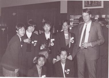
Document - Japanese School of Melbourne
... location, term dates, school hours, curriculum subjects, teachers qualifications, health department approval and enrolment list. Also includes Division of School Duties, school educational aims and guidance priorities. Period covered: 07/09/1968-13/05/1986. 3/An 11/11/1988 Melbourne Development and Prospectus for the Japanese School of Melbourne, includes purpose of school, development options, planning brief, construction time, and development program. Includes seven plans and maps...location, term dates, school hours, curriculum subjects, teachers qualifications, health department approval and enrolment list. Also includes Division of School Duties, school educational aims and guidance priorities. Period covered: 07/09/1968-13/05/1986. 3/An 11/11/1988 Melbourne Development and Prospectus for the Japanese School of Melbourne, includes purpose of school, development options, planning brief, construction time, and development program. Includes seven plans and maps ...Six documents about the Japanese School: 1/The Japanese School of Melbourne Planning Brief document draft February 1984 to the City of Caulfield. Brief includes background of school, current educational standards of school and structure, future plans, including forecast of future student numbers, request to use prefabricated rooms. Also plans for new building and room alterations. Includes appendice which has current and projection graph of students attending. Period covered: January 1968-February 1984 (17 pages). 2/Fourteen page school prospectus, which includes history and location, term dates, school hours, curriculum subjects, teachers qualifications, health department approval and enrolment list. Also includes Division of School Duties, school educational aims and guidance priorities. Period covered: 07/09/1968-13/05/1986. 3/An 11/11/1988 Melbourne Development and Prospectus for the Japanese School of Melbourne, includes purpose of school, development options, planning brief, construction time, and development program. Includes seven plans and maps of school location and bus routes (14 pages). Prepared for the City of Caulfield on its request. 4/List of representatives of the Japanese School of Melbourne that met with City of Caulfield councilors on 23/11/1988. 5/Black and white photo of 'Ian Rob with Japanese students September 1991', six students included. 6/Colour photograph of 'Mayor Ed Biggs with Japanese students February 1992', thirteen adults and young people included.japanese school of melbourne limited, japanese school, caulfield, holy cross catholic, holy cross school, ellington school, keeron street, mockridge stahle and mitchell architects, architects, secondary schools, primary schools, playgrounds, hawthorn road, caulfield south, yaji hidero, japanese community, yazaki yasuo, morita hiroshi, teachers, bloink des, stokes tony, building surveyors, japanese supplementary school of melbourne, school committees, libraries, school houses, brick, bloink clarke harding consulting architects group, anthony stokes and assoc. building surveyors and town planners, rob ian, biggs ed mayor