Showing 10964 items
matching maps
-
 Victorian Aboriginal Corporation for Languages
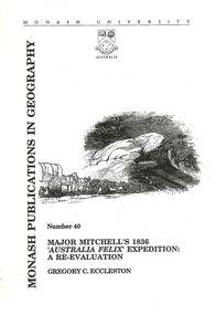
Book, Gregory C Eccleston, Major Mitchell's 1836 "Australia Felix" expedition : a re-evaluation, 1992
Journal style notes with maps and illustrations of the journey of Major Mitchell.maps, b&w illustrations, colour illustrations, tablesthomas mitchell, australia felix, northern victoria, western victoria, local history, exploration -
 Victorian Aboriginal Corporation for Languages
Map, Geographic Data Victoria, Vicmap topographic map index as at June 2000, 2000
Index to Vicmap topographic mapping, including 1:25 000 and 1:50 000 topographic maps, and Outdoor leisure series, compiled by the earlier bodies, Survey &? Mapping Victoria, etc. Also indexes Royal Australian Survey Corps' 1:50 000 topographic mapping.mapsvictorian maps, topographic maps -
 Phillip Island and District Historical Society Inc.
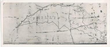
Photograph, Bryant West
... maps ...One of a collection of over 400 photographs in an album commenced in 1960 and presented to the Phillip Island & Westernport Historical Society by the Shire of Phillip IslandPhotograph of an early Map of Phillip Island not drawn to scale. Copy from Records Office, London.On back of photo - "If used must bear acknowedgement - reproduced by permission of the Hydrographer of the Navy" "Received 18/3/1955 from London Records Office per Mr mcGrigor-Phillips" Printed on Map "Phillip Island"local history, photography, photographs, maritime documents, maps, exploration, john jenner, bryant west, phillip island map -
 Magnet Galleries Melbourne Inc
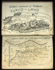
Authors impression of Gallipoli and Sanai desert fighting, mountjoy024.tif
... maps ...A sketched map of Gallipoli and the Sanai desert fightingsanai, egypt, gallipoli, maps -
 Bendigo Military Museum
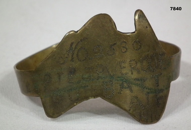
Souvenir - TRENCH ART
Part of the Cooper Collection. "John Percy VERCOE", No. 2530, enlisted 18/5/16 in 5th Reinforcements, 60 BN. Aged 30 years. Embarked for England 25/9/1916, embarked for France 4/2/1917, WIA 26/4/1918. GSW to left eye, severe. Left eye excised England 30/4/1918. RTA 23/9/1918. Discharged from the AIF 4/1/1919. Passed away 30/12/1925. John received a Congratulatory card from MAJ.General J.H. Hobbs, K.C.B, V.D. Commanding 5th Aust. Division - for bravery and devotion to duty in dressing and carrying wounded to the Regt. Aid Post during a counter attack on Villers Brettoneux on the night of 24/25th April 1918.Brass map of Australia fashioned into a bracelet. Band is secured with a clip. Owners details engraved on the map.Engraved in the face of the map: 'No.2530, PTE J.P. VERCOE, 60TH BATT, AIF, 1916.cooper collection, trench art, john p. vercoe -
 Wangaratta RSL Sub Branch
Framed Map and Newspaper
Sketch Map of Bulldog-Wau Road New Guinea drawn to scale by 2/1 Aust Fd Coy dated 23.7.43 and signed by soldiers together with related newspaper article. Hand sketched by Peter Muncey VX10042 a Draughtsman who served in the Middle East Ceylon and New Guinea with the 2/2 and 2/1 Field Coy Royal Australian Engineers. The sketch contains 26 signatures including:- S/Sgt Raymond Hector Ibbotson NX14112 who served in the Middle East and New Guinea Lt Col Jack Graham Wilson NX 130646Bulldog Track also known as Bulldog-Wau road was longer, higher, steeper, wetter, colder and rougher than Kokoda Track. In 1943 Australian Army engineers; the 2/1 and 2/16 Field Company RAE, 9th Australian Field Company (AIF), veterans of Syria, Palestine, Egypt, Greece and Crete, the 1st and 3rd Australian Pack Transport Companies and local Papuan labour cut the road with pickaxes and dynamite over a period of eight months. During five months of operations over seventy per cent of the 2/1 Australian Field Company contracted malaria.Seventeen bridges were constructed; mostly single, but at least one with multiple spans. More than two thousand Australian army personnel and over two thousand Papuans and New Guineans were involved during nine months of construction. Thus the road, acclaimed as the greatest military engineering feat ever, was completed and for the only time in history motor vehicles crossed the high rugged mountains of Papua New Guinea. Carved brown timber frame with cream mount containing hand sketched map with soldiers signatures and two newspaper articles.Sketch Map of Bulldog-Wau Road 23.7.43 2/1 Aust Fd Coy Newspaper - Diggers pushed on with pick and shovelbulldog-wau road, map, new guinea, ww2 -
 Federation University Historical Collection
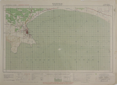
Map, Portland, 1942, 1942
Printed colour map on paper"This map is an official document. If found, it must be handed in to the nearest military headquarters or police. porland, cape nelson, lawrence rock, point danger, whaler's point -
 Halls Gap & Grampians Historical Society
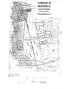
Map - Coloured
... MAPS ...Map showing layout for township of HeatherlieTownship of Heatherlie; Parish of Boroka; County of Borung; scale measurement; R.O. Robson Authorised surveyormaps, heatherlie township -
 Melton City Libraries
Map, Mount Cottrell Fire group, Unknown
... Maps ..."In 1966, the Mount Cottrell Fire Brigades Group was formed as a way of consolidating the smaller groups around Melton, Rockbank, Toolern Vale, Sydenham, Truganina and Werribee. Its headquarters were established at the home of Ernest ‘Bon’ and Edna Barrie in Ferris Road, Melton. Captain Bon Barrie was a member of the Melton Fire Brigade and elected group and communications officer of the new Mount Cottrell Brigades Group". Fire Brigade Meeting 14th September held at Rockbank Formation a new Group in Region 14 Present: R/O H Rothsay, Assistant R/O R Orchard Tru? G Summerton Purpose of Group The pooling of the equipment in the area should be co-ordinated under one leader. The Brigade and private equipment should be co-ordinated under one leader. Formation was carried unanimously. To be called Mt Cotterill Group. Rockbank nominated Captain E W Barrie elected, Secretary K Watt Toolern Vale. Names listed C/O K L McNaughton Anakie Group COO/O R B Chirnside Lieut J Richmond Capt E Gillespie Toolern Vale Eddie L/ T S Atkin Stan L/T B Storey Bert Sec K Watt Keith Capt E W Barrie Melton Bon L/T K Gillespie Keith A Gillespie Arthur L/T G Lunson George L/T J Robinson Jeff Capt A Marquand Truganina Alan L/T I Cowie Ian Sec T Gard Tom Capt G Harrison Rockbank a/ps G Harrison N Harrison N Fisher a/ps S Hirt Melton Steve Pres M Chomley Sydenham Capt S Hughes Stan Capt L Waterson Werribee Lex Res/o J Hanson G/O S Cooper Bacchus Marsh Syd P/GO W Lidgett Wal Pro/O D Dunton G/O T Healy R C [Mt Macedon] Tom Reg Sec G Douglas Hand written notes of Edna Barrie Typed by Wendy Barrie Maps of the Mt Cottrell Fire groupemergency services, maps -
 Running Rabbits Military Museum operated by the Upwey Belgrave RSL Sub Branch
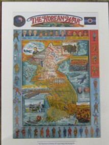
Poster
... Maps ...Map of Koreamaps, korea, general -
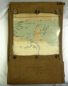 Bendigo Military Museum
Accessory - MAP CASE & MAPS, C.1939 -45
... Maps ...John James Davies No VX35280 enlisted in the 2nd AIF on 1.8.40 age 31 years. At discharge on 30.11.45 he held the rank of WO 2nd class in 2/108th Aust Light Anti Aircraft detachment..1) Map case, canvas khaki. .2) Map of Darwin, NT. Scale 4 miles to 1 inch. .3) Map, folded, New Guinea made by Hec Robinson Sydney .4) Map Pine Creek N.T.zippered section marked "J. J. Davies VX35280 108 LAD”maps, canvas case, military -
 Greensborough Historical Society
Map, John Monash, 1913 Map of Greensborough, 1913
1913 Map of Greensborough, possibly by John Monash. This map shows the area to the north of the township.Map, colour.greensborough - maps, 1913 -
Whitehorse Historical Society Inc.
Map, Railway map of Victoria, 1912
... maps ...Detailed map of railways in Victoria including adjacent areas of New South Wales.Detailed map of railways in Victoria including adjacent areas of New South Wales. Also shows 'principal coach routes'. On verso map of suburban lines with eastern line as far as Croydon and Bayswater. key numbers on map linked to pages of a timetable.Detailed map of railways in Victoria including adjacent areas of New South Wales.maps, railways -
 Colac RSL Sub Branch
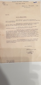
Work on paper - Baulch Collection, Soldier Settlement Documentation. Lot 21 - Minjah Estate
Historic documentsA4 x3 printed sheets:- - Covering letter from the Soldier Settlement Commission dated 19/10/1955 - Map of Minjah Estate - Map showing the subdivision of Minjah Estate1 x typed letter 2 x copies of mapssoldier settlement allocations -
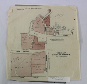 Wodonga & District Historical Society Inc
Map - Hamilton-Smith Collection Subdivision Map of Wodonga
... maps ...The Hamilton-Smith collection was donated by the children of Grace Mary Hamilton-Smith nee Ellwood (1911-2004) and John Hamilton-Smith (1909-1984) who settled in Wodonga in the 1940s. The Ellwood family had lived in north-east Victoria since the late 1800s. Grace’s mother, Rosina Ellwood nee Smale, was the first teacher at Baranduda in 1888, and a foundation member of the C.W.A. Rosina and her husband Mark retired to Wodonga in 1934. Grace and John married at St. David’s Church, Albury in 1941. John was a grazier, and actively involved in Agricultural Societies. The collection contains significant items which reflect the local history of Wodonga, including handmade needlework, books, photographs, a wedding dress, maps, and material relating to the world wars. This item has well documented provenance and a known owner. It forms part of a significant and representative historical collection which reflects the local history of Wodonga. It contributes to our understanding of social and family life in early twentieth century Wodonga, as well as providing interpretative capacity for themes including local history and social history. A printed map of a Wodonga subdivision with hand written annotations On top proper right corner: "Donated by Merrilyn Hamilton-Smith". map, subdivision, wodonga, local history, maps, hamilton-smith, hamilton-smith collection -
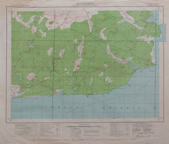 Federation University Historical Collection
Map, Mallacoota, 1942, 1942
Printed colour map on paperThis map is an official document, if found, it must be handed in to the nearest military headquarters or police stationmallacoota, bass straight, cape evarard, cann river, genoa river, disaster bay -
Glenelg Shire Council Cultural Collection
Postcard - Postcard - Australia Map and Portland, Victoria, n.d
Coloured postcard. Map of Australia, which lifts up to reveal a strip of black and white views of Portland. Each view 4.9 x 3 cm. Representation of two 'cowboys' on horseback, with whips, to the left of map of Australia.Front: 'MAP OF AUSTRALIA FROM PORTLAND' -printed in redportland -
 Running Rabbits Military Museum operated by the Upwey Belgrave RSL Sub Branch
Map
... Maps ...Map Malaysia 1150maps, 2002, army -
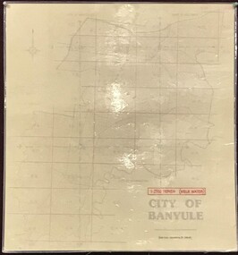 Greensborough Historical Society
Map, Banyule City Council, MMBW, 1:2500 Series. City of Banyule. Master overlay, 1994_
This master overlay is the key to the Melbourne and Metropolitan Board of Works maps: MMBW, 1:2500 Series. The overlay was made by the City of Banyule using the Melways base plan (Edition 23, 1994-95). This overlay can be used to position maps in this series.Laminated map, with overlay of MMBW map grid.mmbw, melbourne and metropolitan board of works, banyule city council -
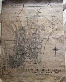 Greensborough Historical Society
Map, City of Heidelberg, City of Heidelberg, - excluding the North Ward, 1959, 27/05/1959
Map of City of Heidelberg showing municipal and ward boundaries; North Ward is excluded from this map.Blue print map"Scale 20 chns to an inch. G.M.H. 27.5.59"city of heidelberg, heidelberg - maps -
Whitehorse Historical Society Inc.
Map, Nunawading - Bromide
... Maps ...Map of the City of Nunawading indicating suburbs - marked 'Bromide'Map of the City of Nunawading indicating suburbs - marked 'Bromide'Map of the City of Nunawading indicating suburbs - marked 'Bromide'maps, city of nunawading -
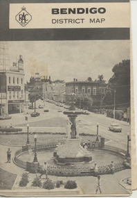 Ballarat Tramway Museum
Map, Royal Automobile Club of Victoria, "Bendigo District Map - RACV", c1971
Printed street map titled "Bendigo District Map", published by the RACV, showing the central part of Bendigo, Bendigo Outlets, streets, principal attractions, Bendigo and district maps and information, and a list of sporting and entertainment facilities. Has the tram lines shown dotted, only shows the full extent of the Golden Square line. The main map has the number "0171" in the bottom left hand corner, indicating the publication date.in ink on the Bendigo Outlet map, "3/4" along bottom edge.trams, tramways, map, bendigo, racv, railways -
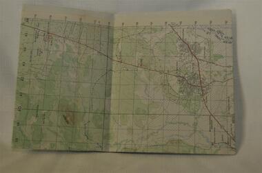
 National Vietnam Veterans Museum (NVVM)
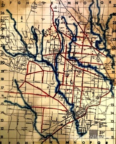
Map, Long Tan Original Battle Map
Original topographical map of Long Tan area showing operational marking in black pen. Areas 1-4 marked 5RAR section.This map is the original map from 1 ATF HQ on the day of the Battle of Long Tan, 18th August, 1966.battle of long tan, map -
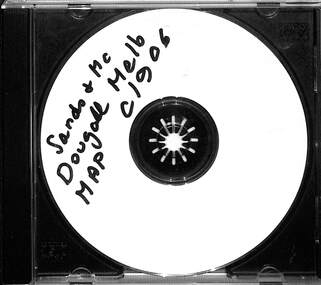 Melbourne Tram Museum
Map - CD - Sands McDougal Map Melbourne c1906, Sands McDougall
Detailed scan of the Sands McDougal Map in colour showing Melbourne's cable trams, railways, Essendon Tramways, NMETL and the Victorian Railways line to Brighton from St Kilda. Includes the MTOCo horse tram lines and the Caulfield horse tram lines. See Reg item 6572 for the actual map. Yields information about Melbourne and its tramways in 1906CD in a plastic case - black with clear cover.CD marked "Sands & McDougal Map c1906"cable trams, tramways, map, sands mcdougal, nmetl, vr trams, horse trams -
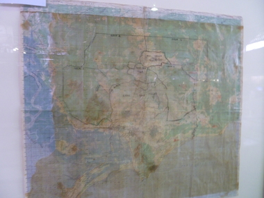
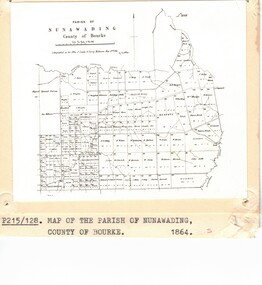 Whitehorse Historical Society Inc.
Photograph - Parish Map, Parish of Nunawading
... Maps ...Black and white photo of map of the Parish of Nunawading, County of Bourke, 1864. Copy also at ND880, Map Drawer.parish of nunawading, county of bourke, maps -
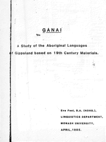 Victorian Aboriginal Corporation for Languages
Thesis, Eve Fesl, Ganai : a study of the Aboriginal languages of Gippsland based on 19th century materials, 1985
Honours thesis in linguistics (unpublished) at Monash University. Detailed studies of Gippsland languages (Ganai) including maps, extensive discussion of historical sources, and a fairly detailed grammatical study of Ganai. Includes wordlists organised by areas of meaning.Maps, word listsganai, gippsland -
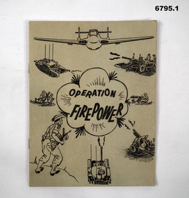 Bendigo Military Museum
Manual - TRAINING MANUALS
1. An instruction manual outlining the structure of a military exercise to practice Battle activity at a Brigade level. 2. An instruction manual outlining the proper way to read a map and the logic of it's structure. 3. Illustrative guide on what leaders should expect in relation to their soldiers. Items in the collection re Col J Swatton, refer Cat No 6719.2P for his service details.1. Green cover, 16 page booklet titled " Operation Firepower" . Dated March 1959, which planned an army exercise at Brigade Level. Outlined aim, Tactical setting, maps and plans. 2. Loose stapled 28 page manual on reading maps. Yellow paper with three folder holes punched in left size. Contains instructions and pictures and examples. 3. Brown covered manual, yellow faded pages, 60 pages inside with pictorial content displaying the do's and don't's of the behaviour of a good soldier.1. Maps have some notations, images of vehicles/weapons on front. 2. Titled " Map Reading - Supplement A.T.M. (AUST) No 12". Written on top " Colonel J.W. Swatton". 3. Titled "Right or Wrong": Element of Training and Leadership illustrated 1937". Stamp on back saying "on loan" but now donated.passchendaele barracks trust, training manuals -
Creswick Campus Historical Collection - University of Melbourne
Map, 1980
Arboretum plant census locality mapsMap -
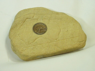 Tatura Irrigation & Wartime Camps Museum
Carving, sandstone, 1940
Item carved by a German Internee who was held in Camp 1 in WW2. Came into the possession of one of the guards, whose nephew donated it to Tatura MuseumSandstone piece with carved map of Austraiia, Tatura 1939-1940, and a 1939 penny inserted in the stone."Tatura Vic.1939-40." Map of Australia/Bird.internment camp 1, tatura, german internee.. -
 Running Rabbits Military Museum operated by the Upwey Belgrave RSL Sub Branch
Map
... Maps ...Topographic map of Nui Datmaps, vietnam, army