Showing 2594 items
matching maps of victoria
-
 The Beechworth Burke Museum
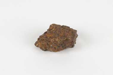
Geological specimen - Laterite
... and map the geology of Victoria. Collecting geological specimens ...Laterite refers to both a rock and a soil type that is rich in clay, as well as Iron and Aluminium. It is created during a process that is called laterization, where high heat and seasonal heavy rainfall cause there to be wet and dry periods, which over time hardens the soil into rock. Because of this, most laterite is formed between tropics of Cancer and Capricorn. The iron oxide in laterite is what gives it it’s orange-red colouring. The largest religious complex in the world, Angkor Wat in Cambodia, is partially constructed of laterite, particularly its foundations, as laterite is porous and allows rainwater to drain. This specimen of laterite was collected from the Democratic Republic of Congo while it was colonised by Belgium in the 19th century. Laterite forms in many parts of the world, particularly between the tropics. It is used both for ore and as a building material, and comparing specimens from different parts of the world allows us to document the different compositions that this mineral can have when formed at different locations. This specimen is part of a larger collection of geological and mineral specimens collected from around Australia (and some parts of the world) and donated to the Burke Museum between 1868-1880. A large percentage of these specimens were collected in Victoria as part of the Geological Survey of Victoria that begun in 1852 (in response to the Gold Rush) to study and map the geology of Victoria. Collecting geological specimens was an important part of mapping and understanding the scientific makeup of the earth. Many of these specimens were sent to research and collecting organisations across Australia, including the Burke Museum, to educate and encourage further study.a palm-sized solid iron-aluminium oxide mineral specimen in shades of brown, orange and greyburke museum, beechworth, geological, geological specimen, laterite, laterite specimen, geology -
 The Beechworth Burke Museum
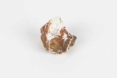
Geological specimen - Montmorillonite
... (in response to the Gold Rush) to study and map the geology of Victoria ...Montmorillonite is a type of clay composed of aluminium silicate that forms very small particles that are not well-bonded to one another. This is why it is so soft. When in the presence of water, all types of clay swell. Montmorillonite swells even more than most types of clay, which is why it is often chosen over other types of clay in its practical uses. Montmorillonite has many different practical uses, including in the mining industry, as a soil additive, as a sealant, as a desiccant to draw water out of the air, to clean ponds, to make kitty litter and in cosmetics. Montmorillonite is a common mineral and, despite being named after Montmorillon, France, can be found all over the world, including many deposits in Australia. It is not known where this particular specimen originates from. Montmorillonite is an economically and socially significant material with a wide variety of uses. Having samples of common and important minerals allows collections, like the Burke Museum, to have a more complete view of the land on which they are located, and therefore a more complete view of heritage. This specimen is part of a larger collection of geological and mineral specimens collected from around Australia (and some parts of the world) and donated to the Burke Museum between 1868-1880. A large percentage of these specimens were collected in Victoria as part of the Geological Survey of Victoria that begun in 1852 (in response to the Gold Rush) to study and map the geology of Victoria. Collecting geological specimens was an important part of mapping and understanding the scientific makeup of the earth. Many of these specimens were sent to research and collecting organisations across Australia, including the Burke Museum, to educate and encourage further study.A solid tennis-ball sized chunk of aluminium silicate clay. It is primarily white, accented with orange and brown.burke museum, beechworth, geological, geological specimen, clay, montmorillonite -
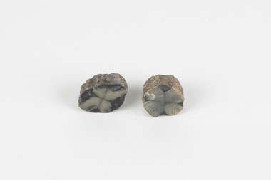
 The Beechworth Burke Museum
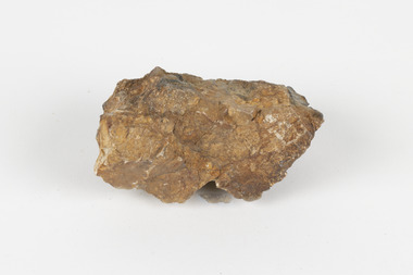
Geological specimen - Cassiterite
... collected in Victoria as part of the Geological Survey of Victoria ...This specimen is Cassiterite in Quartz. Cassiterite is a tin oxide metal that forms in thin crystals which can have a beautiful lustre. Quartz is made of silicon dioxide, also known as silica, and is one of the most common minerals on earth. Cassiterite has been a fundamental source of tin ore for humans throughout history, including today. Tin is an important metal that has a wide variety of human uses in different areas, from dying fabric, to making mirrors, and their most well-known use ‘tin’ cans. Tin cans are primarily made of steel and are coated with tin in order to take advantage of tin’s property of being non-corroding. This is a massive step in the history of food preservation. Tinned food first reached Australia in 1815 with early settlers, and it began to be manufactured here in the 1840s. It was incredibly popular, and was a highly exported product, which would be a contributing factor to the ‘tin mining boom’ of the early 1880s. This specimen was collected at Jingellic, New South Wales, in about 1852. Although the Goldfields of the 1800s are much more well-known, tin mines existed alongside the gold mines which began in the mid 19th century and extended almost one hundred years, to the mid 20th century. Specimens like this would have been used as evidence to justify tin mining operations in the region as an investment. This specimen is part of a larger collection of geological and mineral specimens collected from around Australia (and some parts of the world) and donated to the Burke Museum between 1868-1880. A large percentage of these specimens were collected in Victoria as part of the Geological Survey of Victoria that begun in 1852 (in response to the Gold Rush) to study and map the geology of Victoria. Collecting geological specimens was an important part of mapping and understanding the scientific makeup of the earth. Many of these specimens were sent to research and collecting organisations across Australia, including the Burke Museum, to educate and encourage further study. The Geological Survey of Victoria was headed by British geologist, Alfred Richard Cecil Selwyn (1824-1902), who was responsible for issuing over 60 geological maps during his 17 years as director. These maps were all hand-drawn and coloured and became the benchmark for accuracy for geological mapping. Collecting geological specimens was an important part of mapping and understanding the scientific makeup of the earth. Many of these specimens were sent to research and collecting organisations across Australia, including the Burke Museum, to educate and encourage further study. A fist-sized solid geological specimen made on one half of tin oxide, which is dark grey, and on the other side of silica, which is brown and cream.burke museum, beechworth, geological, geological specimen -
 The Beechworth Burke Museum
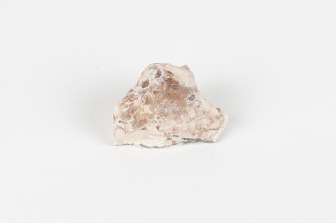
Geological specimen - Opal Bearing Stone, Unknown
... (in response to the Gold Rush) to study and map the geology of Victoria ...There are 17 opal fields in Australia. This opal bearing stone was found in Lightning Ridge, NSW over what is known as the Great Australian Basin. This basin was formed and covers an area of 1.7 million square kilometers in eastern Australia in the Cretaceous period. This basin used to contain an inland sea, which provided an environment where silcrete eventually formed when water levels changed. This eventually seeped into other structures, and eventually hardened and formed opal. Lightning Ridge has a population of around 2000 people, with about 80 000 visitors every year. It is a historic mining town, and is known for its deposits of a rare black opal. Mining started in the area in the late 1800s, early 1900s when the black opal was discovered. This opal-bearing stone is of social and historical significance. It is from Lightning Ridge, which is well-known for being a large producer of opal stones, most famously black opal. The history of the period dates back to 140 million years, with the discovery of black opal in the early 1900s causing interest in the area. This specimen is part of a larger collection of geological and mineral specimens collected from around Australia (and some parts of the world) and donated to the Burke Museum between 1868-1880. A large percentage of these specimens were collected in Victoria as part of the Geological Survey of Victoria that begun in 1852 (in response to the Gold Rush) to study and map the geology of Victoria. Collecting geological specimens was an important part of mapping and understanding the scientific makeup of the earth. Many of these specimens were sent to research and collecting organisations across Australia, including the Burke Museum, to educate and encourage further study.***A palm-sized solid mineral specimen in shades of beige and light orange*** silica based? burke museum, beechworth, geological, geological specimen, opal, opal fields, australia, lightning ridge, new south wales, great australian basin, cretaceous, silcrete, black opal, mining -
 The Beechworth Burke Museum
Geological specimen - Chiastolite
... collected in Victoria as part of the Geological Survey of Victoria ...It is made up of andalusite. Andalusite is a rock-forming mineral, sometimes found in granite or schist. It is often used to make glass, ceramic products, chemicals, and heat-resistant bricks as it can withstand high temperatures without changing. The chiastolite contains particles of graphite, which arranges in geometric patterns. When crystal growth occurs in the rock, the granite particles concentrate at crystal interfaces and can result in cross shapes. These ‘cross stones’ have been valued and used for their spiritual or religious meaning and used as charms, gems, or amulets. Chiastolite was first discovered in 1754, seen in a description in a published book by a palaeontologist, Franciscan priest, and Spanish author, Jose Torrubia. Deposits have been found in Australia, France, the USA, Chile, Canada, Spain, Brazil, Sri Lanka, and Russia. Deposits have been found in Western Australia and South Australia. This particular specimen was found in Bimbowrie, South Australia. Other chiastolite specimens have been found in Bimbowrie, along with jasper, quartz, and aventurine in the form of rolled pebbles or schist. This chiastolite specimen is socially and historically significant. It is a very rare sort of andalusite mineral. It is from one of only two locations where it is regularly found in Australia. The carbon cross has made it an important religious symbol in the past. Its ability to withstand high temperatures has made it a common ingredient in heat-resistant bricks and ceramics today. This specimen is part of a larger collection of geological and mineral specimens collected from around Australia (and some parts of the world) and donated to the Burke Museum between 1868-1880. A large percentage of these specimens were collected in Victoria as part of the Geological Survey of Victoria that begun in 1852 (in response to the Gold Rush) to study and map the geology of Victoria. Collecting geological specimens was an important part of mapping and understanding the scientific makeup of the earth. Many of these specimens were sent to research and collecting organisations across Australia, including the Burke Museum, to educate and encourage further study.A metamorphic mineral consisting of andalusite, with a cross shaped graphite pattern in colours of grey, brown and yellowburke museum, beechworth, geological, geological specimen, andalusite, chiastolite, geometric, cross stone, spiritual, religious, australia, south australia, bimbowrie, quartz, jasper, aventurine, schist -
 Orbost & District Historical Society
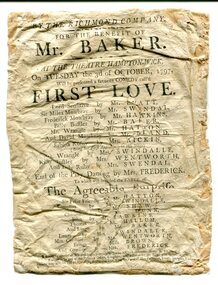
program, 1797
"The theatre itself was located in a barn close to the village pond. Its location is indicated on the attached 1827 map of Hampton Wick and the Swan arrowed where tickets were to be had. The picture of Ye Swan around 1900 is probably not too dissimilar to how it would have looked in 1797. One of the regular patrons at the theatre is believed to have been William, Duke of Clarence (later King William IV, uncle of Queen Victoria). The Duke lived in Bushy House about a mile away from the village and was a known devotee of theatrical entertainments. The theatre had disappeared by 1865. It would have been a touring company who were playing on the night of 3 October 1797." ( information from Ray Elmitt, historian of Hampton Wick ) The doors were to be opened at 6 to begin precisely at 7 o'clock,. Boxes were 3 shillings, Pit seats were 2 shillings and seats in the gallery were 1 shilling. Tickets could be bought at the printing office in Kingston or from Mr Ansel of Adam and Eve in Kingston or from Mr Pattenden of the Swan in Hampton Wick. "First Love" is a 1795 sentimental comedy play by the British playwright Richard Cumberland. It was first performed at the Drury Lane Theatre in May 1795. Frederick Mowbray becomes the protector of Sabrina Rosny after her abandoment by Lord Sensitive. The Agreeable Surprise is a 1781 comic opera to music by Samuel Arnold and a libretto by John O'Keeffe. The work in two acts was first performed at the Theatre Royal, Haymarket (London), on 3 September 1781. It was one of the most performed works of its kind in London in the last quarter of the 18th century. In England the 18th century saw the flourishing of theatre as a popular pastime. Many theatres were enlarged and new playhouses built in London and the provinces. This item was kept as a souvenir / memento and brought to Australia by an early settler.A very old program from the Richmond Company at the Theatre Hampton-Wick. It is white with black print. There are two performances - First Love and The Agreeable Surprise. There is a cast list for each. theatre hampton-wick-richmond-company -
 Orbost & District Historical Society
handkerchief, c. 1899
The Daily Mail printed this handkerchief to raise funds for the "Soldiers' Families Fund" after the outbreak of the Second Boer War (1899-1902. (The Daily Mail, devised by Alfred Harmsworth (later Lord Northcliffe) and his brother Harold (later Lord Rothermere), was first published on 4 May 1896 and was an immediate success.) Patriotic handkerchiefs were popular during the Victorian era and this one featuring a popular song and well-known people was probably the most popular.This handkerchief was produced to raise funds for the families of soldiers involved in the Second Boer War. This fund, The Soldiers' Families Fund was the first such charitable effort for a war. The handkerchief and other related items raised more than 250,000 pounds.A white linen man's handkerchief. It is printed in blue. It has a map of the South African Republic and the music and words of The Absent Minded Beggar - music by Arthur Sullivan, words by Rudyard Kipling. There is a picture of Lord Roberts, the British Commander in Chief, in the top left corner with the British flag and a picture of Queen Victoria in the bottom right corner.handkerchief souvenir boer-war -
 Orbost & District Historical Society
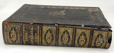
book, History of Australasia, 1879
"The History of Australasia" by David Blair was one of three important publications of the author. Written in 1879, the book relates the history of both Australia and New Zealand from their discovery through to the establishment of self-government in both colonies. Blair was born in Ireland and after studying for the ministry in Ireland came to Australia in 1850. Instead of a missionary career he took up journalism, became a member of the Legislative Assembly in Victoria and published his books on Australasia.A large thick hard leather covered book -History of Australasia by David Blair and published in 1879. The covers are black with a gold pattern border. The front cover shows an embossed Australian crest in gilt with kangaroo and emu and ' Advance Australia'. It is an illustrated edition with beautifully coloured maps for each Australian colony and New Zealand.book blair-david history-australasia -
 Orbost & District Historical Society
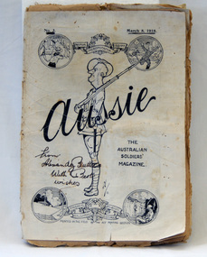
magazine, Aussie, March 18, 1918
Alexander Butters enlisted on 12 November 1914 as a gunner. He was awarded a Meritorious Service medal for his "determination and courage .....setting a splendid example to his men..." on the SOMME. 'Aussie' (1918- circa 1929) was a commercial magazine of opinion, review and entertainment. It was edited by Phillip Harris and published in France 1918 - 1919 on a small printing press that Harris brought with him to France. Initially the print run was only 10,000 copies, but soon it reached 60,000 and later 100,000. The magazine celebrated a distinctive 'Aussie' identity through language, humour and imagery. It distributed news, provided light-hearted ways of seeing the war experience and gave soldiers an outlet to express dissent or dissatisfaction. It also provided a voice for Australian authors such as Banjo Paterson, C.J. Dennis and Bernard O'Dowd. (Ref Museum Victoria)This magazine provides an Australian soldiers' view of the political and world climate during World War I, and also represents the bond between Australian soldiers. The magazine celebrated a distinctive ?Aussie? identity, through language, humour and their assertion of what it meant to be an Australian. It allowed news to be distributed, gave the soldiers an outlet to express any dissent or dissatisfaction, thus preventing any greater form of rebellion and promoted Australian authors like Banjo Paterson, C.J. Dennis and Bernard O'Dowd. (Ref. Museum Victoria)A thin black and white paper magazine called "Aussie". This is Volume 3. The magazine contains stories, illustrations, songs and poetry from the First World War. On the front cover the title is printed across the centre, with a drawing of a soldier in uniform standing sideways, and holding a gun. Four drawings within circles are positioned in each corner, joined by a wreath and ribbons bearing the names of the war fields. His head is in the shape of the map of Australia. On front cover - From Alexandy Butters with best wishesmagazine ww1 aussie military -
 Orbost & District Historical Society
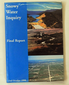
book, Snowy Water Inquiry, Snowy Water Inquiry Final Report, 1998
The Snowy Water Inquiry was commissioned in 1998 with a brief to recommend environmental water release options to the Commonwealth, Victorian, and NSW Governments so that corporatisation of the Snowy Mountains Scheme could proceed. These release options related to the Snowy River below Jindabyne, the Murray River and other rivers associated with the Scheme. The Inquiry objectives were that the recommendations would not adversely impact on water supplies to existing irrigators or the viability of the Snowy Mountains Scheme. (ref snowyhydro.com.au)This report contains information about water allocation and uses of the Snowy River.A book of 160 pp - Snowy River Inquiry Final report 23rd October 1998. Submitted to the Governments of New South Wales and Victoria / Commissioner: The Hon. Robert Webster. On the front cover are three aerial photographs of the Snowy River and Snowy Hydro Scheme. The book contains maps and photographs. snowy-river snowy-hydro snowy-mountains government-inquiry -
 Orbost & District Historical Society
magazines, East Gippsland Victoria, 1978
The magazine is a travel book and is probably one of a series.A glossy magazine titled, East Gippsland - Victoria. It contains coloured photographs. This is a 24pp travel book containing coloured illustrations, maps and descriptions of East Gippsland. There are historical details/articles in the book. The photography is by George Hurdes and Ian Roberts. The cover which was designed by Bill Stockdale has a colour photo of a yacht with a predominantly blue background of water and sky. The text is by Barbara Glover.travel east-gippsland -
 Orbost & District Historical Society
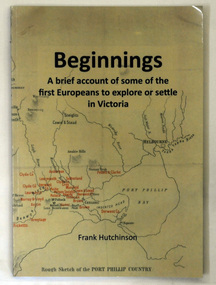
book, Beginnngs, 2011
"A map on the wall of his parent's shop in country Victoria is what got Frank Hutchinson interested in the geography and early settlement of Victoria. He later moved to Ballarat where he spent most of his working life. Whilst there his interest in the early explorers continued until about ten years ago he began to compile the listing which developed into the present publication." (ref.Port Phillip Pioneers Group) When he commenced the research and writing of Beginnings, it was not intended for publication. It was a project of personal interest. A soft covered 122 pp book title Beginnings a brief account of the first Europeans to explore or settle in Victoria. On the glossy front cover is a rough map of Port Phillip Bay. Print is black. a chronological list of the earliest visits to Victoria and attempts to settle. The book contains: brief notes on the exploration and earliest settlement of the state, region by region and a summary of the early Murray River paddle steamer industry.hutchinson-frank history-victoria prahran-mechanics-institute -
 Orbost & District Historical Society
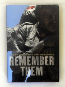
book, Remember Them, 2009
This guidebook shares the personal stories of the individuals honoured in 250 of Victoria's key war memorials. It covers metropolitan Melbourne and regional Victoria, providing a unique insight into wartime history and the local heroes who fought overseas. Garrie Hutchinson has authored and edited over 30 books, In the early 1970s Hutchinson was heavily involved in anti-war activism and alternative journalism. From the late 1970s Hutchinson moved away from writing poetry and towards a journalistic career.This is a significant research tool.A 308 pp hard cover book with a dust jacket titled Remember Them, A guide to Victoria's Wartime Heritage. The author is Garrie Hutchinson. On the front cover is a photograph of a close-up image of a sculpture of a soldier. The text is dark grey.It is arranged geographically, with accompanying maps and photographs,military-history memorials-victoria -
 Orbost & District Historical Society
book, Broadbent's Melbourne - Sydney Guide Book, 1936
Broadbent's Official Road Guides Company took over George R. Broadbent's business in 1935. In 1963, it changed its name to Broadbent's Road Maps Pty. Ltd. George Robert Broadbent (1863-1947), cyclist and map publisher, was born on 3 November 1863 at Ashby near Geelong, Victoria. At various times Broadbent held most Victorian and Australian road cycling records. Broadbent became an active vice-president of the Good Roads Association of Victoria in November 1912 and was consulted regularly during the preparation of the country roads bill. That year he took over the Argus motoring column, wrote tirelessly on road improvements and maintenance, and became manager of the Automobile Club's new touring department in 1914.A 160 pp road guide book titled Broadbent's Official Road Guide Melbourne - Sydney. The front cover has a yellow background with a map of the coastline from Sydney to Melbourne, the Prince's Highway route marked. This is inset in a drawing of a car driving along the coastal road.The book contains speedometer readings, route maps, advertisements and photos of points of interest. In the top right is the logo of the Royal Automobile Club of Victoria and at the bottom right is the price 1/-.traavel road-guides broadbent-george car-touring -
 The Beechworth Burke Museum
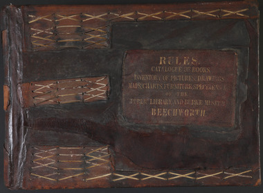
Book - 1875 Catalogue, William Detmold, RULES / CATALOGUE OF BOOKS / INVENTORY OF PICTURES, DRAWINGS, / MAPS, CHARTS, FURNITURE, SPECIMENS / OF THE / PUBLIC LIBRARY AND BURKE MUSEUM / BEECHWORTH, 1875
This large, leather bound journal was made for the Public Library and Burke Museum in Beechworth by book manufacturer, William Detmold in 1875. It was commissioned by the President of the Library and Burke Museum committee, Dr Antoine Mousse, for the purpose of cataloguing all the items in the collection. The cataloguer was the curator at that time, William Morton, whose hand-writing appears in the journal today. When William Morton first started recording in this journal in 1875, there were already a number of existing items in the institution. The Public Library and Burke Museum in Beechworth had actually been operating since the 1850s; first as a Young Men’s Association in 1856, then as Beechworth Athenaeum in 1858, then as the Beechworth Public Library in 1860. Then in 1861 when news of the death of Beechworth’s former police superintended, Robert O’Hara Burke, reached the town, it was agreed that the Public Library would also become a museum to tribute his legacy, renaming it as the ‘Public Library and Robert O’Hara Burke Memorial Museum, Beechworth’. Many of the items from the early institutions would have been used to form the nucleus of this new organisation. Plus, the additional items that were either collected or donated to develop it into a museum. The catalogue is extensive. There are exactly 461 pages of recorded items, each page detailing the various collections the museum acquired in the late 19th century. Collections recorded in this catalogue include a large collection of geological specimens, that were given to the museum in 1868 by the Geological Survey Department of Victoria. A large collection of taxidermy mounts, that were given to the museum as skins by the Museum of Australia in 1865. An extensive collection of Aboriginal artefacts that were purchased from amateur anthropologist R. E . Johns in 1868. As well as artworks, charts, photographs, machinery, maps etc., all of which have been held in the museum since. This catalogue also details the governance and management of the organisation. There were originally 30 rules that governed the actions for the management committee and, while anyone could read in the free library, only subscribers could borrow two books and one periodical. At first, subscriptions rates were 7/6 a quarter. This was later changed to £1 per annum, paid quarterly in advance. This was a considerable amount; 7/6 per quarter meant that the annual fee was £1.10. This was equivalent to about £650.00 or about $1,182.00AUD today, while the reduced subscription fee of £1 a year was the equivalent to £450.00 or about $818.00AUD today. Membership of the athenaeum would have been the reserve of the town's notable citizens. The vale of the catalogue lies not only in its historical connect with the establishment of the Athenaeum and the current museum, but also in its record of the names and positions of all members of the institution's committees of management from 1875-1876. This is a unique object that contains important records for a notable country town. Large brown leather bound book made in 1875 for the Beechworth library and museum by William Detmond. Inside is a comprehensive and detailed itemised listing of the paintings, drawings, charts, photographs, specimens and books that entered the institution from 1850 -1882. non-fictionCover: RULES / CATALOGUE OF BOOKS / INVENTORY OF PICTURES, DRAWINGS, / MAPS, CHARTS, FURNITURE, SPECIMENS / OF THE / PUBLIC LIBRARY AND BURKE MUSEUM / BEECHWORTHburke museum, beechworth, catalogue, museum catalogue, 1875, william morton, william detmold, exposition universelle, ferdinand von mueller, public library, collection, book, leather bound, restored, digitised, robert o'hara burke, hand-written -
 The Beechworth Burke Museum
Photograph, 1920-1950
This image taken between 1920-1930 depicts open-cut hydraulic sluicing at the Three Mile Mine, located about five kilometres south of Beechworth. Alluvial, or surface, mining began on this site in the 1850s, but was soon replaced by hydraulic sluicing methods. By the start of 1880 it is estimated that nine hundred miles of water races had been cut though soil and rock in the Beechworth district. Hydraulic sluicing employs high pressure jets of water to blast away large areas of earth and wash it down to be run through a sluice box. Gold gets caught in the sluice and the remaining slurry is washed away. Large water quantities were required for hydraulic sluicing, and the long water races and deep tailraces that were constructed were considered great engineering feats. This method of mining is extremely effective, but causes significant environmental damage and impacts to waterways and agricultural operations. Miners at Beechworth built extensive networks of races and dams to secure reliable supplies of water on a scale far greater than elsewhere in Victoria. By the 1880s Beechworth's water barons continued to hold more than half of all the water right licences on issue and undertook sluicing operations on a massive scale. The manipulation of surface and ground water via race networks was well planned and recorded in detail by local mining surveyors. The maps that were created, combined with modern geo-spatial technologies, provide a vital key in understanding the great lengths to which miners went to capture and control critical water resources. Today, Three Mile mine is called Baarmutha. The Three Mile Mine was unproductive until 1865 when John Pund and three other miners secured a fifteen year license and constructed a water race from Upper Nine Mile Creek to Three Mile Creek. In the early twentieth century Pund & Co. averaged over one thousand ounces of gold per year from the mine. After Pund's death in 1915, GSG Amalgamated Co operated the site, continuing sluicing until 1950. This image of hydraulic sluicing methods shows the extent of water-works engineering in the landscape. This photograph has historic and research potential for understanding changes to the landscape, the evolution of mining methods, and the extensive construction, manipulation and management of water networks in the Beechworth district. Black and white rectangular photograph on matte paperReverse: 7597-1 / Sluice Mining / Copied from original on loan from Webb (Qld) / Donated Nov 2009 / Baarmutha Three Mile Mine c1920-1950 / Managed by the Plain Bros then Parkinsons / Current Location is: Beechworth Animal Shelter / used for Baarmuthaburke museum, beechworth museum, beechworth, gold fields, gold rush, victorian gold rush, hydraulic sluicing, spring creek, netwown falls, mining tunnels, water races, tailraces, gold ming history, colonial australia, australian gold rushes, mining technology, beechworth historic district, indigo gold trail, indigo shire, john pund, water manipulation, water engineering, three mile creek, three mile mine, water race, large-scale mining methods, historical mining construction, alluvial mining, mining environmental impacts, baarmutha, water barons -
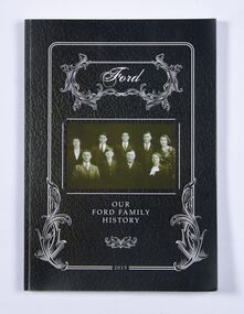 Ballan Shire Historical Society
Book - Book, Ford - Our Ford Family History, 2015
A history of the Ford Family and descendants, pioneer settlers of the Morrisons/Meredith area in Victoria. Contains photographs, family trees, documents, newspaper cuttings, maps, narratives etc. Black and white only.This book is significant in that it contains valuable historic information on the Ford and Brawn families. The publication is private and intended for the information and interest of family members and others researching the family.Book, soft cover, perfect bound, with a leather look cover and a photograph of family members with a scrollwork surround.ford, brawn, bant -
 Flagstaff Hill Maritime Museum and Village
Document - Navigation Chart, Admiralty Office, Lady Bay and Warrnambool Harbour, 03/04/1871
This Chart titled “Lady Bay and Warrnambool Harbour” was surveyed by Nav. Lieut. H.J. Stanley, of Britain's Royal Navy, in 1870 and printed in April 1871. The chart was made before the Warrnambool Breakwater was built (construction had begun in 1874 and was completed in 1890). The chart includes Directions for entering Lady Bay, Warrnambool Harbour. These are "Vessels entering Warrnambool Harbour must bring the Red Light in sight and steer in with it in line with the upper white Light bearing North, until the Green Light on the Jetty is opened, when steer towards it and anchor. The best anchorage is in 2 ¼ fms [fathoms)] of water, about a cable from ledge off Breakwater rock. Or where convenient, according to draught of water, only endeavouring to anchor as close as possible to Breakwater rock. It is not safe to enter or leave the Harbour in south westerly or Southerly gales.” This chart is significant for its strong connection to the maritime history of Warrnambool Harbour and Lady Bay, and eventually to the Warrnambool Breakwater. The Warrnambool Breakwater is registered as a place of significance on the Victorian Heritage Database (VHR H2024). A copy of the same chart was used to plan several submissions for future changes to the jetty and breakwater. The chart is a historical record of structures existing in 1870; the Warrnambool Jetties, Lady Bay, the leading lights (lighthouses), streets, roads, bridges and many buildings. It also shows the lay of the land and seabed.Canvas chart of Australia, South Coast, Victoria Title: Lady Bay and Warrnambool Harbour Surveyed by Nav. Lieut. H.J. Stanley, R.N., 1870. Magnet Variation, 1870 Published April 3, 1871, by the Admiralty, London. Directions for vessels entering Warrnambool Harbour are printed on the chart. The chart has a lacquer or seal over it.Top of chart has logo "HYDROGRAPHER OFFICE" "Price Eighteen Pence". "Engraved by Edward Weller" Along bottom of Chart: “London… Published at the Admiralty, 3rd April 1871, under the Superintendence of Rear Admiral G.H. Richards, F.R.S. Hydrographer, Corrections July 71” Bottom of chart “Australia South Coast Victoria Lady Bay and Warrnambool Harbour. 2494”flagstaff hill, warrnambool, chart of lady bay warrnambool 1870, warrnambool harbour, cartography, navigation, warrnambool breakwater, 1871, australia – south coast / victoria, lady bay, 1870, nav. lieut. h.j. stanley, r.n, directions for entering warrnambool harbour, hydrographer office, rear admiral g.h. richards, edward weller, port of warrnambool, flagstaff hill maritime museum & village, maritime museum, maritime village, shipwreck coast, map, chart, navigation chart, admiralty chart, breakwater, jetty, pier, vhr h2024 -
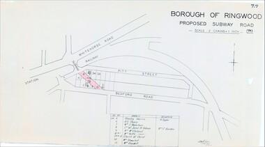 Ringwood and District Historical Society
Map, Borough of Ringwood, Victoria - Proposed Subway Road - 1943
... , Lot 55 Mrs Goodall. Borough of Ringwood, Victoria - Proposed ...Technical drawing by D.H. Oliver dated 22/9/43 showing residential lots affected by proposed road extending from Warrandyte Road railway underpass into Pitt Street and Bedford Road. Includes list of owners and occupiers of properties - Lot 4 Stanley Harris /R. Taylor, Lot 6 R.S. Sharp, Lot 7 William J. Wakeham, Lot 8 Janet R. Gibson /Mrs C. Burden, Lot 9 Mrs McClelland, Lot 10 part Mrs. Yetts, Lot 11 part 10 Church of Christ, Lot 54 Mrs Shwerkolt, Lot 55 Mrs Goodall.Scale: 2 chains = 1 inch. -
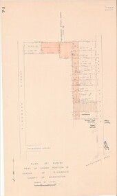 Ringwood and District Historical Society
Map - Plan of Survey, Part of Crown Portion 12, Parish of Ringwood, Victoria - circa 1930
... , Victoria - circa 1930. Map Plan of Survey ...Map of area bounded by Ringwood Street, Melbourne Street and Adelaide Street, showing details of Adelaide Street allotments and existing outbuildings. Certificate of Title numbers include Ringwood Street C/T 3418-553, C/T 3563-433, Adelaide Street C/T 7151-047, C/T 7038-465, C/T 7098-464, C/T 7098-465, C/T 3604-635, C/T 8066-900, C/T 3866-118, C/T 3609-728, and C/T Vol 3670 Fol 133992.Subsequent additional notations identifying 1971 closure of Melbourne Street North, and properties of Hone, Patendon, Pines Hosptial, Mail Office, Presbyterian Church and Falconers Grocery Shop on Whitehorse Road corner. -
 Ringwood and District Historical Society
Map, Proposed Subdivision - Hilltop Estate, Heathmont, Victoria - circa 1925
... - Hilltop Estate, Heathmont, Victoria - circa 1925. Map ...Plan of Part of Crown Allotments 16 & 18, Parish of Ringwood, County of Mornington. Subdivision includes Site for Heathmont Station, Heathmont Road, George Street, Lilian Street, Edith Street, Edna Street, Great Ryrie Street. Inset locality plan also shows nearby Electric Railway Estate and Heathmont Station Estate. L.H. Webber, Licensed Surveyor, 440 Little Collins Street, Melbourne. -
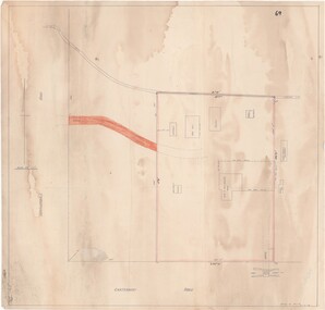 Ringwood and District Historical Society
Map - Ringwood Animal Welfare Clinic, 1958 Land Survey Drawing, Ringwood, Victoria
... , Ringwood, Victoria Map Ringwood Animal Welfare Clinic ...Plan of driveway and property east of Heatherdale Road and Canterbury Road corner, with details of house, shed, bungalow, dog pen, kennels and enclosures.Survey by H.L.M. 31-7-58. Scale 20'=1" -
 Ringwood and District Historical Society
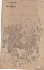
Map, Borough of Ringwood, Victoria - c.1950s
... of Ringwood. Borough of Ringwood, Victoria - c.1950s. Map ...A0-size (approx) linen-backed municipal engineer’s survey map of named streets and lot-numbered properties within Borough of Ringwood.Scale: 8 chains to 1 inch. -
 Ringwood and District Historical Society
Poster, Land Sale Advertisement - Pinemont Estate, Ringwood, Victoria - circa 1924
Map of residential allotments for sale, with terms of sale, summary of subdivision features and local services and facilities, and photographs of local street scene and lake (Loughnan's Lake - location not marked), Subdivision includes Wonga Road (later Loughnan's Road), Glenvale Road, Kubba Road, Felix Crescent, Summit Crescent, Pine Crescent, Aurum Crescent, Hygeia Parade, Panorama Avenue, Avalon Grove, Montalbo Road, Cielterre Avenue. Sole Agents T.M. Burke Pty Ltd, 340 Collins Street Melbourne Phones 6294, 6779. Map by S. Callanan, Licensed Surveyor, 107 Elizabeth Street Melbourne. Date of poster estimated from railway services information extract " ... 36 fast electric trains to Flinders Street daily ... proposed electrification to Croydon ..." . Timeline for electrification of Lilydale Line record indicates Box Hill to Ringwood January 1923, Ringwood to Croydon November 1924 (Source: History of Croydon - McGivern, Vol.1 p20). -
 Ringwood and District Historical Society
Map - Public Land Sale by Thomas Ham, 2000 Acres for Sale - Crown Sections 20, 23, 24 - Ringwood, Victoria - 1855
... - Ringwood, Victoria - 1855 Map Public Land Sale by Thomas Ham ...Two 1850s surveyor's maps on cardboard backing showing area from Melbourne extending East beyond Bulleen and Nunawading. Detailed description of lots for sale and navigational directions to the property from Richmond by Thomas Ham, Victorian public servant, map maker, publisher, lithographer and original Ringwood land owner. Inset map enlarging area between Yarra River and Dandenong Creek, with southern boundary of allotments later forming part of Oban Road, North Ringwood.TRANSCRIPT: "This really valuable Property is now offered to the public for sale, in lots to suit purchasers at the Iow rate of £1 per Acre for 80 acres and upwards, and £1.10s per Acre for any smaller portion. Terms of payment Half Cash, Balance in 6 and 12 months, bearing 8 per cent interest. The Estate is well wooded with Gum, Cherry Tree and Stringy Bark, with Wattle in the valleys of the several creeks. Every lot is Staked and Trenched at the corners marked on the Plan thus - The Surveyor has carefully sub-divided the Property, in order to give every Farm a Creek for Water, Valley for Cultivation, and Hills for House and Grass Paddock. The ROADS have been very carefully laid out so as to give a firm, well drained, and nearly level road to each Homestead. Intending purchasers can readily find the property by the following directions, viz: Start from Richmond Bridge, at Hawthorne, then take the left-hand road to KEW. When at the "Woodman Inn", take the Cotham Road to the right, bearing due east, keep this Road, passing Trainor's "White Horse" Inn, and before you leave the fences, you will see calico bills (see margin) nailed to the Trees on the bush track leading to the Upper Yarra country, follow the Bills till you come to the SOUTH boundary line of the Property, which bears East and West (see Plan) where you will see Bills nailed up "THIS PROPERTY FOR SALE, etc." The Bills from Town lead direct to where Mr. Jull is erecting his Store, and arrangements have been made with him to show the lots to intending purchasers free of charge. At the respective corners of the lots the Bills are nailed up double, with numbers to denote the lot, and that the corner stake is adjacent. Any parties wishing to proceed to the property by way of BULLEEN will find Bills nailed on the Trees, commencing at the NEW INN, at "Wilson's Slip Rail." Keep this Track till you come to the Log Bridge, over the Deep Creek at Bloxhome's Paddock; go through the land now being cleared; keep the track over the hill till you come to an Iron House, you will then be on the property, which Iies to the North and East as per Plan. Follow the Bills till you come to Mr. Jull's Store, etc. etc. Further particulars can be had from the Agent for the Property. THOMAS HAM. " -
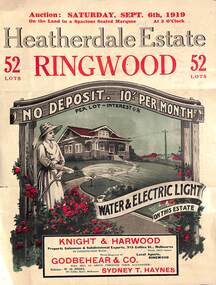 Ringwood and District Historical Society
Pamphlet - Land Auction Brochure, Heatherdale Estate, Ringwood, Victoria - 1919
Double sided leaflet advertising subdivision site, layout of streets and allotments, summary of local features and services and terms of sale. Inset photographs of local views and residence of F.W. Purches on the Estate.Auction Saturday September 6th, 1919. 52 Lots. Subdivision includes White Horse Road, Witt Street, Mitcham, Station Street (later Victory Street, Mitcham). (Railway Avenue marked on the map did not eventuate). Agents - Knight & Harwood, 315 Collins Street, Melbourne in conjunction with Godbehear & Co, Phone Ringwood 49, selling through their auctioneer - Sydney T. Haynes. Solicitor W.H. Peers, 395 Collins Street, Melbourne. -
 Ringwood and District Historical Society
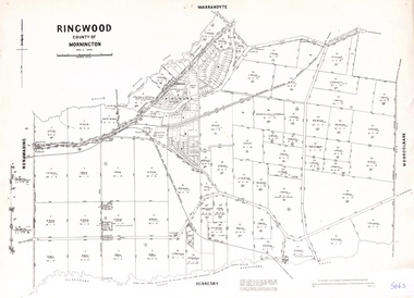
Map - Parish of Ringwood, County of Mornington, Victoria, Original Land Owners
Laminated Parish map of Ringwood detailing original Land Owners' names, property locations and acreages. Details reproduced in 1957 by the Department of Lands and Survey, Melbourne, from original surveys of varying dates. -
 Mission to Seafarers Victoria
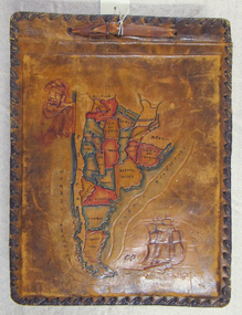
Album - Photographic album, Allan Charles Quinn
This photo album documents the voyage of Allan Quinn while he was in the merchant navy. The album and photos give a view of Quinn's trips around the world and the many places he visited. Leather-bound photo album. Cover is embossed with a colour map of South America.The cover contains the map of South America with a picture of a man with a pipe in his mouth in the top left-hand corner and a picture of a sailing ship in the bottom right. The inside front cover lists in handwritten columns: ports of call during 1947-48. There are three loose photos inside the front cover. album, photos, allan quinn, tourism, seafarers, sailors, seamen, ships -
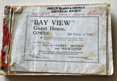 Phillip Island and District Historical Society Inc.
Booklet, Victorian Country Hotel & Guest House Guide 1939-40 "Where to go" in Victoria, 1939
Details of tourist accommodation options on the IslandHistoricalSmall, red bound booklet with maps, tables, descriptions and photos advertising tourist accommodation in country Victoria.Victorian Country Hotel & Guest House Guide 1939-40 "Where to go" in Victoriatourist brochure, bayview guest house, guesthouses, carisbrooke guesthouse cowes phillip island, cowes progress association, cora lynne, the isle of wight hotel cowes phillip island, phillip island hotel, douglas house, hollydene guest house, osborne park guesthouse, marldon house, bonnie doon, yackatoon, elsford, widgee -
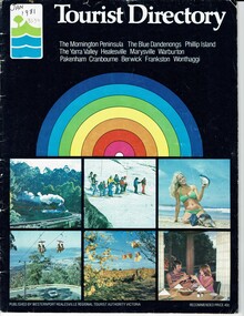 Phillip Island and District Historical Society Inc.
Booklet, Tourist Directory 1981 and Guide to Phillip Island & surrounds 1995
HistoricalLarge black booklet with brightly coloured cover with tourist photos. Inside is black type with descriptions, maps, advertisements and photos. Guide is smaller with white and red writing and maps. Inside it has red writing on history, climate and information on Phillip Island and small advertisements of attractions.Tourist Directory, Published by Westernport Healesville Regional Tourist Authority Victoria. Printed by Standard Newspapers, Cheltenham. Guide to Phillip Island & surrounds.Phillip Island Information Centre RMB 1305 Newhaven.tourism, tourist brochure, accomodation, restaurants, map of phillip island