Showing 360 items
matching mining and geology.
-
 Whitehorse Historical Society Inc.
Document, Intrusive rocks of Melbourne, 1976
Copy of page 373 from 'Geology of Victoria' on intrusive rocks of Melbourne by K.G. Bowen.Copy of page 373 from 'Geology of Victoria' on intrusive rocks of Melbourne by K.G. Bowen. At Tally Ho there is a circular plug, considered to be quartz diorite.Copy of page 373 from 'Geology of Victoria' on intrusive rocks of Melbourne by K.G. Bowen.mines and mining, geological society of australia -
 Rutherglen Historical Society
Map, 1908
This is a map produced as part of a book entitled.. It is also stamped on the back in blue ink with an oval ring and the words North of England Institute. Newcastle. Mining & Meterolgical Faculty. Purchased on 23rd July 2017 by the Society after research by member Simon Killeen. Mining map of one of the first mines in Rutherglen area ( Chiltern West)Cream paper, black printing, rectangle with a drawingGeographical Survey of Victoria, Memoir, No6. Plate XX Plan of Underground Workings CHILTERN VALLEY CONSOLS MINE, RUTHERGLEN, PARISH OF CHILTERN WESTgold, rutherglen, mining, chiltern, underground mine map, geological survey, reef drives -
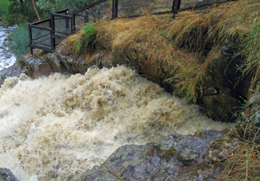 Ballarat Heritage Services
Photograph - Digital photographs, L.J. Gervasoni, Hepburn Blowhole blowing, c2004
Water flowing through the tunnel at The Blowhole, Hepburnhepburn, landscape, heritage, hepburn regional park, mining, blowhole, floods, weather, geology -
 Bendigo Historical Society Inc.
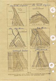
Document - REEFS AND SPURS ON BENDIGO GOLDFIELD
Three pages of information (copied ) regarding reefs and spurs on Bendigo Goldfield. Page 1020 'Geology of Australian ore deposits', drawings labelled in blue biro: No 19 level Virginia Mine, No 6 level South Virginia; No 9 level, Big blue, Big Blue, Deborah Cons'ted ( consolidated?) North Deborah. On bottom ' cross sections through various saddle reefs, showing the range of shape possible, and the association with monchiquite dykes' Page 1021 ( cont) Virginia South Extended; 3000ft New Chum Rly; Catherine Reef, Spurs in Carlisle. On bottom ' Cross sections through a trough reef, 'double' saddle reef and spurry systems. Final page: mines listed and descriptions of workings: Golden Age, Johnson's Reef Extended, Golden Pyke, Constellation, Great Northern, Virginia, Specimen Hill United, New Argus, Clarence United, North Argus, South New Moon.bendigo, mining, reefs and spurs -
 Bendigo Historical Society Inc.
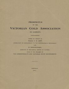
Document - MCCOLL, RANKIN AND STANISTREET COLLECTION: VICTORIAN GOLD ASSOCIATION, 1931
Prospectus of the Victorian Gold Association N.L. Based on a report by Messrs H. W. Gepp Consultant on Development to the Commonwealth Government and W. Baragwanath, Director of the Geological Survey of Victoria. Dated 1931 This company was formed to investigate the Deborah Mine, The Central Nell Gwynne Mine and the Monument Hill Mine. 12 pages including maps and Transverse Sections of the MinesThe Commonwealth and Victorian State Governments. E. Whitehead & Co., Pty., Ltd Printers 21 Equitale Place, Melbourne, C1.gold, mining, prospectus, bendigo, gold mines, victorian gold associatian, deborah mine, central nell gwynne mine, monument hill mine. -
 Bendigo Historical Society Inc.
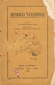
Book - JOAN O'SHEA COLLECTION: BENDIGO GOLDFIELD BOOK, 1936
Joan O'Shea collection. Buff coloured book issued by Mines Department Melbourne. Victoria Australia 1936. Information contained within refers to History, Recent developments and future Prospects, Geology, Lines of Reef for the Bendigo area, information regarding tonnage of gold and values of same at that time. The index at the rear of the book lists all of the mines in the Bendigo area.Geo. Brown, Secretary for Mines, Mines Departmentmining, business, mines department -
Bendigo Historical Society Inc.
Photograph - Aerial shots of parts of Bendigo 1934, 1934
AERIAL SHOTS OF PARTS OF BENDIGO 1934 Catalogue No.10584 This document contains scans of a unique set of aerial photographs that were taken over the City of Bendigo on Friday 12th January 1934, at about midday. The photographs were commissioned by Bendigo Mines Limited during their exploration and mining program designed to revitalize the Bendigo Goldfield. The photographs were given to the Victorian Mines Department sometime in the 1950s. The photographs were taken at a relatively low level of about 4000 feet. This gives a very detailed picture of Bendigo as it was in the 1930s. The photos cover the City Centre and are mainly of the goldfields on the south side of the city; the extent of which covers approximately the four corners of Myers Flat, Maiden Gully, Mandurang and One Tree Hill. Streets, roads and places of interest have been identified as best as possible in December 2023. There are 44 maps, and each references the adjoining maps.Typed Notes with CD The CD is one of two and contains a set of 46 images: The folder named "High_Resolution_800dpi" contains the original digital files that were produced by scanning the photographic prints (About A3 size) at 800 dpi using a high quality, large pformat, roll scanner. These files may be too large for some computers. A second CD contains a direstory called "Low_Resolution_300dep" The images in the folder names "Low_Reolution_300dpr" have a lower resolution (300 dpi) and have been rotated 90 degrees clockwise so that the Northern margin of each image is a the top of the screen. Clive Willman Senior Geologist Geological Survey of Victoriahistory, bendigo, bendigo mines, bendigo maps, bendigo aerial photos -
 Bendigo Historical Society Inc.
Document - KANGAROO FLAT GOLD MINE COLLECTION: MEMO TO SANDNER FROM WILLMAN
Two page memo 17 January 1984, to R. Sandner, D. Cahill, R. Cameron, P.Vail and D. Andrew from C.E. William. Topics covered: Deborah lease project; Brunswick Mine Costerfield, E.L's 1397 and 1398; town planning permit application; historical research and geological assessment, dewatering programme.bendigo, gold mining, deborah lease project -
 Bendigo Tramways (managed by the Bendigo Heritage Attractions)
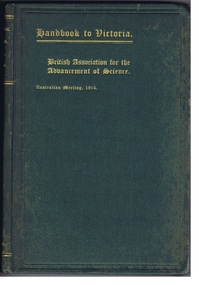
Reference Book, Albert J. Mullett, Government Printer, Melbourne, Handbook to Victoria- British Association for the Advancement of Science, CIRCA 1914
1914 Handbook prepared for the members of the "British Association for the advancement of science" on the occasion of their visit to Victoria, under the direction of the Victorian Executive Committee. Hard covered green handbook, gold leaf lettering. Printed text with Illustrations, Maps, Plans and Diagrams.Stamped: "WITH THE COMPLEMENTS OF THE GOVERNMENT STATIST." victoria, 1914, education, population, immigration, mining, geology, land, law, government, forestry, maps, public works. -
Stawell Historical Society Inc
Archive, Geological Survey of Victoria 1903 Brown Cover, 1903
1903 Brown Coverstawell, mining -
Stawell Historical Society Inc
Map, Victorian Geological Map, 1963
Victorian Geological Mapstawell, mining -
Tarnagulla History Archive
Photocopy of booklet: List of Nuggets Found in Victoria, List of Nuggets Found in Victoria, 1912 (original)
Murray Comrie Collection. Photocopy of the publication 'List of Nuggets Found in Victoria ' being No. 12 in the Memoirs of the Geological Society of Victoria.tarnagulla, nuggets, gold, mining, prospecting -
Bendigo Historical Society Inc.
Map - STRUGNELL COLLECTION: BENDIGO GOLD FIELD GEOLOGICAL SURVEY, 1936
BHS CollectionBendigo Goldfieds Geological Survey. Prepared in the Bendigo Office Bottom Section of original map.Dept of Mines Victoriabendigo, gold mining, geological map -
 Federation University Historical Collection
Map - Geological Survey, J. Phillips, Geological Survey of Victoria - Ballarat, 1857, 10/1858
Geological map of the Ballarat District featuring four colours.ballarat, geological, geology, geological plan, main road, camp, golden point, pennyweight hill, clayton hill, ballaarat cemetery, bakery hill, specimen hill, soldiers hill, nightingale lead, native youth black hill flat, white flat, mining, mines, eureka lead, old post office hill -
Federation University Historical Collection
Map - Map - Geological, Geological Survey of Victoria - Ballarat, 09/1858
Coloured Geological Map of Ballarat, edged with masking tape. The map show alluvial silt, gold drift, geological orders, volcanic, and gold workings. Scale is 8 chains to an inch. WGS 84 Centroid: 37 degrees 33 feet 33 inches south 143 degrees 52 feet 02 inches east W.E. extent: 5km NS extent: 3 kmballarat, ballaarat, geology, goldfield, phillips, j. phillips, mining, alfred selwyn, ferguson and mitchell -
 Eltham District Historical Society Inc
Book, Jenny Brown et al, Out of the Mist; Osborne Peninsula, 2024
The Osborne Peninsula on the Yarra River at Warrandyte accommodates a limited number of properties and residents (70 households). The area is rich in geology and ecology, and an unusually rich endowment of human, built and creative history. Contents: Welcome: The landform: The River: Aboriginal occupation: The Miners: North Warrandyte :The Subdivision: The Lowes: The Osbornes: The Last Osborne: The Elders: The Relics: Dray Track: Water Wheel"Kauri Plaque: River track: Pines: Windmill Creek Bridge: The Koornong School: The Houses" Man Cave: MidCentury Classic: Enduring Original" Masterwork: The Muddies: The State Park: The Saving of Koornong Reserve: The Landcare Story: Flora and Fauna: The Vulnerable, Endangered and threatened: Birds: Mammals: "Waring" the wombat: Reptiles: Fish: Invertebrates: Flora: Fire. Published by the North Warrandyte (Osborne Peninsula) Landcare Group. Includes photos from EDHS collection.64 p. : ill., map ; 29.7 x 21 cm. (2 copies)yarra river, birrarung, dray track, fauna, geology, houses, indigenous history, koornong reserve, koornong school, lowe family, mining, mudbrick houses, north warrandyte, osborne family, warrandyte state park, water wheel, north warrandyte (osborne peninsula) landcare group, osborne peninsula -
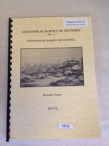 Stawell Historical Society Inc
Book, Norman Taylor, Geological Survey of Victoria No3, Geological Survey of Stawell, 1875-1876
Geological Survey of Stawell 1875/76 by Norman Taylor, Geological SurveyorYellow Card Front and Rear Cover with B/W Picture of mining scene. with black Plastic spineGeological Survey of Victoria No.3 Geological Survey of Stawell Norman Taylor 1875/76stawell mining -
 The Beechworth Burke Museum
Geological specimen - Fossil Leaves
A fossil refers to any remains or traces of past life that are preserved in the rock. It could be remains of plants or animals. Fossil leaves are commonly found on different types of rocks. These fossils can go as far back as the Triassic Age just like the series of fossil plants collected at Denmark Hill, Ipswich in Queensland. Fossils leaves are formed when dead plants get buried by sediments like mud, sand, or volcanic ash. Often, it gets detached cleanly from stems along a special layer of weak cells, then twigs, and, less commonly, cones of conifers and fruits and seeds of flowering plants. Over time, the leaves or pieces of leaves get buried by more sediments and eventually gets 'lithified' or hardened into a rock. Erosions and mining can cause the rocks to break and reveal the fossils buried in it. Fossilisation frequently takes place at sites in the lowlands where deposits of clay, silt, sand are found. This is usually due to weathering and erosion of rocks. Fossil leaves can provide information about ancient Australia's way of living. It contributes to Victorian biodiversity records and its botanical collections. It also contributes information on the geographical profile of Victoria as fossilisation usually occur at estuaries and deltas of rivers, river flood plains, ponds and lakes. This specimen is part of a larger collection of geological and mineral specimens collected from around Australia (and some parts of the world) and donated to the Burke Museum between 1868-1880. A large percentage of these specimens were collected in Victoria as part of the Geological Survey of Victoria that begun in 1852 (in response to the Gold Rush) to study and map the geology of Victoria. Collecting geological specimens was an important part of mapping and understanding the scientific makeup of the earth. Many of these specimens were sent to research and collecting organisations across Australia, including the Burke Museum, to educate and encourage further study.Piece of light brown rock with fossilised leaves in shades of golden yellow and brown.Existing label: Fossil Leaves / Locality unknown / might be worth checking if this is Glossopteris, a Permian age plant. / C. William 16/4/21 geological specimen, geology, geology collection, burke museum, beechworth, fossil leaves, fossilization, 1868 geological survey of victoria, lithified, rocks, fossilised leaf, rock, fossils, leaves -
 The Beechworth Burke Museum
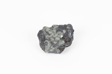
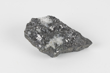
Geological specimen - Garnet (red crystals) in galena (silvery metallic) and green feldspar, Unknown
Garnet is a popular gemstone used in jewellery due to its hardness and durability. There are about 5 varieties of Garnet, which distinguish the colour of each stone. In Australia mostly Pyrope and Aimandine varieties are found; Pyrope, which is blood-red to black and Aimadine, which is brownish-red to black. Other varieties are rarely found in Australia. The garnets visible in this specimen are likely Pyrope. Galnea is the natural mineral form of lead sulphide and has had various uses throughout history; from makeup to car batteries. It was first mined in South Australia in 1841. Green feldspar is an amazonite mineral, a variety of the potassium feldspar called microcline. This particular mineral is considered uncommon. It has been used in jewellery throughout history. It is likely that this specimen was found in Broken Hill, NSW, presumed due to findings of specimens with similar combinations. Broken Hill is Australia’s longest-lived mining city. The city’s fortunes have come and gone against an extreme economic background of boom and bust which continues today.This geological specimen is a rarity, given that is formed of three distinct minerals and the richness of colour that remains visible in this item attests to the strength of each structure. As we cannot pinpoint exactly where this specimen was found further research can only strengthen what is known about mining within Australia. As such the item is significant due to its scientific rarity and its ability to represent three specimens in one. A solid palm-sized mineral that features shades of grey, red and green. garnet, galnea, green feldspar, minerals, mining, rare specimen -
 The Beechworth Burke Museum
Geological specimen - Galena (with quartz), unknown
Galena is the natural compound of lead and classed as a sulphide, it crystallises in a cubic pattern and its chemical formula is PbS. Galena is a primary source of both lead and silver. This specimen of Galena comes from Broken Hill. Broken Hill has one of the world’s largest and most significant deposit of ore for the production of lead. Mining of Galena at Broken Hill began with the staking of land by Charles Rasp in 1883. By the following year, in 1884, Rasp and six others had formed Broken Hill Mining Company. Broken Hill Mining Company eventually evolved into BHP group limited and is currently the largest mining company in the world and the largest company in Australia. There is archaeological evidence from artefacts discovered in Turkey that humans have been extracting lead from galena by the process of smelting since at least 6500 BCE. This specimen also has quartz on the top surface which is frequently discovered alongside Galena. This mineral specimen is of historic significance as a sample of Galena extracted from Broken Hill during the 19th century. Mining for Galena in Broken Hill begin in 1883 by Charles Rasp and evolved into the world’s largest mining company – BHP Group Limited. Broken Hill is one of the world’s most significant deposits of ore for the production of lead. This specimen is part of a larger collection of geological and mineral specimens collected from around Australia (and some parts of the world) and donated to the Burke Museum between 1868-1880. A large percentage of these specimens were collected in Victoria as part of the Geological Survey of Victoria that begun in 1852 (in response to the Gold Rush) to study and map the geology of Victoria. Collecting geological specimens was an important part of mapping and understanding the scientific makeup of the earth. Many of these specimens were sent to research and collecting organisations across Australia, including the Burke Museum, to educate and encourage further study.A flat, hand-sized, grey sulphide specimen that is the natural compound of lead with a quartz formation on the top surface. Existing Label: GALENA / (with quartz) / Locality: Broken Hill / N.S.W 120 x 70 x 29geological specimen, geology, geology collection, burke museum, beechworth, galena, galena quartz, quartz, charles rasp, broken hill mining company, bhp group limited, bhp, lead, ore, lead sulphide, sulphide, silver, broken hill -
Bendigo Historical Society Inc.
Map - STRUGNALL COLLECTION: BENDIGO GOLD FIELD GEOLOGICAL SURVEY, 1936
BHS CollectionBendigo Goldfieds Geological Survey. Prepared in the Bendigo Office Lower Section of original map. Note with map says other items donated - yet to be catalogued. TO BE FOUNDDept of Mines Victoriabendigo, gold mining, geological map -
Bendigo Historical Society Inc.
Map - STRUGNELL COLLECTION: BENDIGO GOLD FIELD GEOLOGICAL SURVEY, 1936
BHS CollectionBendigo Goldfieds Geological Survey. Prepared in the Bendigo Office Top Section of original map.Dept of Mines Victoriabendigo, gold mining, geological map -
 Bendigo Historical Society Inc.
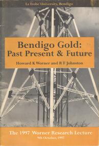
Document - BOOKLET: BENDIGO GOLD: PAST PRESENT & FUTURE - THE 1997 WORNER RESEARCH LECTURE, 1997
BHS CollectionSoftcover booklet produced for the 1997 Worner Research Lecture 9 October 1997. Cover contains black and white photograph of a poppet head, with gold coloured inserts bearing the title, authors and date. 29 pages with the contents of the lecture together with illustrations and photographs. Lecture covered the history and geology and the refractory gold ores.Published by Lat Trobe University Authors Howard K Worner and R F Johnston.bendigo, gold mining -
 Bendigo Historical Society Inc.
Booklet - Albert Richardson Collection: Bendigo Goldfield, MInes Department, Victoria 1936, 1936
Albert Richardson was an expert on the history of the Bendigo Goldfield. The Albert Richardson Park at Victoria Hill, is named in his honour. He was a prominent member of the Bendigo Historical Society. Fifty one page booklet. On front page: Bendigo Goldfield, issued by Geo Brown, Secretary for Mines, under the authority of The Hon. E.J. Hogan, M.L.A., Minister of Mines. Mines Department, Melbourne, Victoria, Australia, 1936.Content includes: historical information; recent development and future prospects, geology and lines of reef. Reef lines described are: Tysons, Lightning Hill, Hustlers, Derby, Paddy's Gully, Garden Gully, Deborah, Sheepshead, New Chum, Nell Gwynne, British and Foreign, Napoleon, Lancashire, Carshalton, Thistle, Christmas and Birds. On front cover 'Bendigo Goldfield, Geo Brown, Sec. for Mines, 1936' written in black pen. On first page 'A.Richardson, 29 Harrison Street, Bendigo' The booklet is annotated throughout by Albert Richardson, for example, the mines along the New Chum Line are further described with their date of formation, sill heights and area of claim.albert richardson, gold mining, goldfield, reef lines, 1936 -
 Bendigo Historical Society Inc.
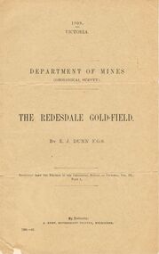
Document - MCCOLL, RANKIN AND STANISTREET COLLECTION: THE REDESDALE GOLDFIELD, 1909
1909 report from the Department of Mines Geological Survey on the Redesdale Goldfield by E. J. Dunn. F.G.S. Reefs mentioned are the Horseshoe Bend Reef, Linda Reef, Bill Smith's workings, the Ben Guy Reef and the Amelia ReefDepartment of Minesgold mining, miners' safety cage, redesdale goldfield, gold mining, redesdale. -
 Federation University Historical Collection
Book, William Harvey Emmons, The Principles of Economic Geology, 1940, 1940
The book was used by Charles Bacon who studied at the University of Nevada in the late 1930s/early 1940s. Bacon worked at Bunker Hill Mines and Kellogg Idaho, before arriving in Australian in 1951. He worked for CN Myers, a company involved with paper converting. CN Myers was a family business (on Charles Bacon's maternal line). William Emmons was Professor and head of Geology and Mineralogy at the University of Minnesota; Director of Minnesota geological Survey; and previously Geologist, Section of Metalliferous Deposits, United States Geological Survey.Maroon soft covered book of 529 pages. Chapters include Magmatic Segregations, Pegmatities, Hypothermal Deposits, Sedimentary Depostis, Openings in Rocks, Metasomatic Processes, Mineral Associations and more.Inside front cover "Charles Bacon 1940 Lincoln Hall Ass. University of Nevada Reno, Nevada"charles bacon, mining engineering, metallurgy, university of nevada, mackay school of mines, geology, california -
 Ballarat Heritage Services
Photograph - Image - Black and White, Golden Point, Ballarat
Black and white image showing the site of the earlies discovery of first rate mining importance to Australia. The gold occurs in gravel lying on Lower Palaeozoic slatesgolden point, ballarat, gold, geology, gold discovery -
Bendigo Historical Society Inc.
Map - BENDIGO GOLD FIELD GEOLOGICAL MAP
Geological map of the Bendigo Gold Field showing stratigraphical zones. Map in two sections, colour coded showing anticlines, synclines, shafts, fault lines, fossils. Signed by H. Herman. This map forms part of the Geological Survey of Victoria, Structure of Bendigo Goldfield report, No. 47, 1923. H.Herman, late Director of Geological Survey.Geological Survey Victoriabendigo, gold mining, geological map -
Bendigo Historical Society Inc.
Map - SECTIONS ACROSS BENDIGO GOLDFIELD
Map in three sections showing sections across Bendigo Gold Field, showing anticlines, synclines, faults, stratigraphical zones and mines along the reef lines. Key shows rock types Castlemaine, Bendigo B1, B2, B3 and B4, and Lancefieldian. First part of map shows sections A-A, B-B and C-C. Reef lines drawn with mines listed: Fault line shown are the Carshalton, Stafford, New Chum, Virginia and Clarence. A datum line shows 600 ft above sea level. On bottom of plan: ' Prepared in the Geological Survey Office, Bendigo, under the direction of H. Herman, late Director of Geological Survey, from surveys by H.S. Whitelaw, Field Geologist, assisted by E.S. Usher, A.J.J. Moore and R.A. Keble.' Second section of map shows sections D-D, and E-E. Fault lines listed are the Tambour Major fault, Carshalton fault, Stafford fault, Nell Gwynne fault, New Chum fault, Deborah fault. Third section shows sections F-F and G-G. Fault lines listed are the Bird Reef fault, Kangaroo Gully fault, Langdon fault, Carshalton fault, Nell Gwynne fault, Spring Gully fault, Hustlers fault, Gravel Hill fault, Ordes fault, Thanet fault. This map forms part of the Geological Survey of Victoria, Structure of Bendigo Goldfield report, No. 47, 1923. H.Herman, late Director of Geological Survey.Geological Survey of Victoriabendigo, gold mining, reef line maps -
Bendigo Historical Society Inc.
Map - BENDIGO GOLDFIELD VERTICAL PROJECTIONS
Map of Bendigo Gold Field in two sections showing 'vertical projections along several anticlinal axial planes showing pitch, stratigraphical zones, faultlines, shafts and etc.'. Bulletin No 47 written top left hand side. Lines of reef described: Christmas line Lancashire line Nell Gwynne line New Chum line Hustlers line Garden Gully line Sheepshead line Mines along the reef lines are listed. This map forms part of the Geological Survey of Victoria, Structure of Bendigo Goldfield report, No. 47, 1923. H.Herman, late Director of Geological Survey. On bottom of second section : Prepared in the Geological Survey Office, Bendigo, under the direction of H. Herman, late Director of Geological Survey, from surveys by H.S. Whitelaw, Field Geologist, assisted by E.S. Usher, A.J.J. Moore and R.A. Keble.Geological Survey of Victoriabendigo, gold mining, reef lines