Showing 1086 items matching "navigation"
-
 Moorabbin Air Museum
Manual - Private Pilots Licence Courses, Private Pilot Course Navigation and Flight Planning
Study guide of navigation & flight planning for private pilot studentsSpiral bound manualnon-fictionStudy guide of navigation & flight planning for private pilot studentsaircraft navigation -
Moorabbin Air Museum
Book - Air Navigation, Air Navigation Royal Air Force
Text on the theory and practice of air navigation for RAF trainees, circa 1944Green hardback with frayed spine . Published 1944non-fictionText on the theory and practice of air navigation for RAF trainees, circa 1944 -
Moorabbin Air Museum
Map (Item) - Maps of Northern Australia and New Guinea, AUS RNC 5 and 6 radio navigation maps
-
Moorabbin Air Museum
Manual - Private pilot courses, Private Pilot Course Navigation and Flight Planning
Overview of navigation & flight planning for student private pilots, circa 1981Overview of navigation & flight planning for student private pilots, circa 1981 -
 Moorabbin Air Museum
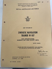
Manual (Item) - (SP) AAP 7573.028-3-8 Synthetic Navigation Trainer W-107 Test Specs, Royal Australian Air Forcce Synthetic Navigation Trainer W-107 Test Specifications Numbers 20071 - 20082 ( except 20073
RAAF -
Moorabbin Air Museum
Book - Flight training for private pilots, Flying Training For The Private Pilot Licence Instrument Flying, Radio Navigation, Instrument Approach Procedure
Study guide on instrument flying, radio navigation & instrument approach procedure for private pilots circa 1980snon-fictionStudy guide on instrument flying, radio navigation & instrument approach procedure for private pilots circa 1980sflight traning for private pilots -
Moorabbin Air Museum
Manual (Item) - Global Navigation GNS 500A Operators Manual
-
Moorabbin Air Museum
Manual - Trans Australia Airlines training manuals, TAA Boeing 727 - 200 Aircraft Navigation and Auto - Flight
Overview of TAA navigation & auto flight systems on TAA Boeing 727 - 200 airliners, circa 1980Spiral bound manual with missing front covernon-fictionOverview of TAA navigation & auto flight systems on TAA Boeing 727 - 200 airliners, circa 1980 -
Moorabbin Air Museum
Manual - Trans Australia Airlilnes training manuals, TAA Electrical Instrument Training Manual DC - 9 Series 31 Auto Pilot - 22 Navigation - 34
Overview of TAA Douglas DC - 9 auto pilot & navigation systems circa 1976non-fictionOverview of TAA Douglas DC - 9 auto pilot & navigation systems circa 1976 -
Moorabbin Air Museum
Manual - Trans Australia Airlines training manuals, TAA Electrical Instrument Training Manual B727 Series 100-200 Autopilot & Navigation
Overview of autopilot & navigation systems for TAA Boeing 727 - 100 to 200, circa 1975non-fictionOverview of autopilot & navigation systems for TAA Boeing 727 - 100 to 200, circa 1975 -
Moorabbin Air Museum
Manual - Trans Australia Airlines training manualds, TAA Training Manual Boeing 727 34 Navigation 22 Autopilot
Overview of Boeing 727 navigation /autopilot systems fortrainee engineers, circa 1982non-fictionOverview of Boeing 727 navigation /autopilot systems fortrainee engineers, circa 1982 -
Moorabbin Air Museum
Manual - Aircraft navigation systems, Very Low Frequency Navigation Systems
Collection of hand written & printed notes on low frequency navigation systems, circa 19853 ring foldernon-fictionCollection of hand written & printed notes on low frequency navigation systems, circa 1985hyperbolic navigation systems, navigation terms, gns-500a series 3 maintenance -
Moorabbin Air Museum
Journal - The Journal of Navigation, The Journal of Navigation Volume 64 Supplement 1 November 2011
Articles on aviation & non aviation navigational matters circa 2011non-fictionArticles on aviation & non aviation navigational matters circa 2011miscellaneous non aviation navigation matters -
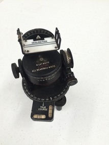
 Nhill Aviation Heritage Centre
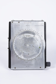
Navigation Computer
This type of instrument typically used by pilots and navigators for quick calculations of Air Speed and Wind Drift.hand operated navigation computer. Rotating scale on the front panel and a scroll type scale on the inner panel with a winder knob on the right side. Front panel is hinged at the top and bottom has two curved thigh pads.Indent No. G6B/145 RAAF Serial No. WG/2967* I.C.A.N. in center of front dial COMPUTER NAVIGATIONAL Ml. III D. -
 Queenscliffe Maritime Museum
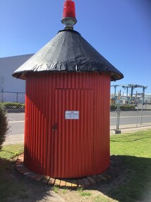
Functional object - Channel Marker - Colour Red
Portside channel marker from west channel Port Phillip. This red circular building had a red navigational light on top and was know as Tuckey.Portside channel marker from West Channel Port Phillip. Circular red building with red navigational light on top. west channel marker, tuckey -
 Flagstaff Hill Maritime Museum and Village
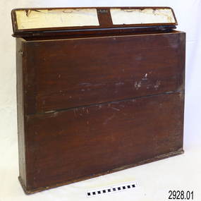
Container - Chart Case, Late 19th to early 20th centuries
This case was donated along with the contents of over 60 navigational charts for locations all over the world. The narrow box is built to keep the charts in order and easily accessible on board a vessel. The chart case is a rare example of a container used on board a vessel for the storage and protection of navigational charts. It represents the type of equipment used by the navigator of a seafaring vessel. The charts within the case represent the places to which the vessel travelled.Chart case (or map case), wooden, has hinged opening at top. Front of case folds down and has a hook closure. It contained 65 British Admiralty navigational charts, which are listed and stored separately. (See separate items 2928.2 to 2928.66)There is a hand written name on the back of the case.flagstaff hill, warrnambool, shipwrecked coast, flagstaff hill maritime museum, maritime museum, shipwreck coast, flagstaff hill maritime village, great ocean road, map case, chart case, map box, chart box, british admiralty charts, navigational charts, hydrographer charts, navigation, ship equipment -
 Lakes Entrance Historical Society
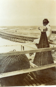
Photograph - Navigation Basket, 1920c
Also black and white copy 20 x 14 cmBlack and white photograph showing navigational baskets used at entrance to Gippsland Lakes from Bass Strait. Girl sitting on handrail framework, looking at eastern pier and ocean. Lakes Entrance Victoria navigation, ocean -
 Bendigo Military Museum
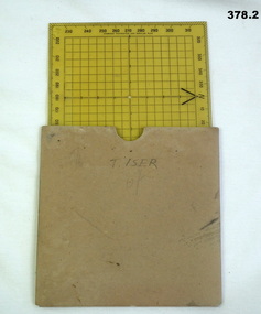
Equipment - PROTRACTOR, SQUARE, C.1939 -45
Belonged to Thomas Henry ISER No V24933 and VX102660 2nd AIF. Refer Cat No 383.2 for his service history..1) 360 deg Protractor labelled as "Direction finder" Used for map navigation planning,yellow plastic. .2) Cardboard sleeve for .1).marked "T. ISER"navigation, protractor, military, equipment -
 Port Fairy Historical Society Museum and Archives
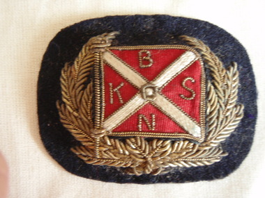
Badge - Hat Badge, Chas. R Martin. Melbourne, 1880-1925
Part of Capt. William Robertson's Collection. Spare cap badge of the Belfast and Koroit Steam Navigation Company - S.S.Casino uniform.Small cap badge: gold emboridered cap badge of laurel leaves around red and cream flag of Belfast and Koroit Steam Navigation Company on Black felt backgroundBKNSlocal history, costume, male uniform, civilian, s.s.casino, robertson, captain or mr william, belfast and koroit steam navigation company -
 Flagstaff Hill Maritime Museum and Village
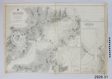
Document - Navigation Chart, British Admiralty, Otago Harbour, Late 19th to Early 20th century
Navigation charts are used by mariners around the world for navigating waterways. This chart was created for Otago Harbour in New Zealand. A ship "Otago' was named after this harbour and was once commanded by renowned maritime author Joseph Conrad. That ship now lies in Otago Bay, in the Derwent River, Tasmania.This navigation chart was published by the British Admiralty cartographer, to aid mariners to navigate the world's water bodies. Navigation charts are still used today, along with other navigational instruments.British Admiralty Navigation Chart - Otago Harbour, South Island, New Zealand. Chart shows insets with finer detail of important sections.warrnambool, shipwrecked-coast, flagstaff-hill, flagstaff-hill-maritime-museum, maritime-museum, shipwreck-coast, flagstaff-hill-maritime-village, shipwrecked-artefact, british admiralty navigation chart, navigation chart, british admiralty, otago harbour, south island, new zealand, otago bay, derwent river, tasmania, joseph conrad -
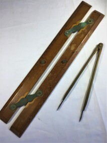 Queenscliffe Maritime Museum
Equipment - A parallel ruler and dividers
Navigational equipmentNavigational equipment A timber and brass parallel ruler and brass dividersparallel ruler, dividers, navigation, chart reading -
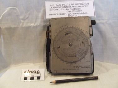 Waverley RSL Sub Branch
RAAF Navigation Computer
Used by RAF and RAAF during WWII Believed to have been used in the battle of britainMetal faced bakelite box with rotating dial on front and a paper graph sheet enclosed in front cover a pencil for plotting course and position is attached to the side of the unitNavigational Computer ICANican computer, battle of britian computer, aircraft computer, mechanical computer -
Moorabbin Air Museum
Manual (item) - CAC Boeing 757 maintenance training
autoflight communications navigation -
 Nhill Aviation Heritage Centre
Instrument - Astro Compass
This instrument is the type used in the Nhill Air School navigation trainingBlack metal instrument with pivot points and white markings to 360 degrees. Telescope sighting piece and bubble level gauges and screw adjusters. Includes separate sight original fitting.AM, Astro Compass Mk.Ii, 6A/1174O, 4Pastro compass, navigation, instrument -
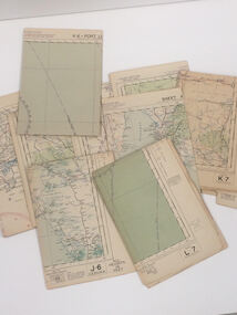 Nhill Aviation Heritage Centre
Map - Aeronautical Maps x 9, May 1943
Typical of the maps used during navigation training here at Nhill during WW2Aeronautical maps of Victoria, Printed on light card green text and markingsThird Edition May 1943, Sheet K8, Australian Aeronautical Map, Equatorial scale 1:1000,000map, aeronaughtical map, navigation -
 Royal Brighton Yacht Club
Trophy, Stars and Compass
The Stars and Compass Trophy was donated by Richard Hawkins in 1998 (the Year of the Oceans) to encourage the use of traditional navigation skills by yachts at sea. See attached document for more extensive background informationnavigation, hawkins -
Glenelg Shire Council Cultural Collection
Functional object - Lamp, navigational, c. 1983
Port of Portland collection. This lamp was originally part of the 'Tarragal', tug boat.Stern navigational light. White-painted copper case with hinged lid. Fastened with hinged latch and clasp on a chain. 180 degree dioptric lens. Fitted with incandescent lamp. Folding handle on top. Three mounting lugs around base.Front: MASTHEAD/ Seahorse/ G. B./ 59680 Back: (no inscriptions)tarragal, port of portland collection, navigation, light -
 Running Rabbits Military Museum operated by the Upwey Belgrave RSL Sub Branch
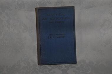
Booklet
Practical Air Navigationdocuments, ww2, raaf -
 Dandenong/Cranbourne RSL Sub Branch
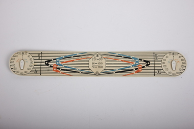
Tool - Navigational Instrument?, Memorabilia, Unknown
UnknownPlastic navigational instrument?2 x circles printed on either side numbering 20 to 160 .Some Japanese writing on sides. In centre has number 20K - 30K. H = 100/V =180. -
Queenscliffe Maritime Museum
Instrument - Ruler, navigational
Staedtler Navigational Rulernavigational instruments, ruler