Showing 736 items matching "nillumbik historical society inc."
-
 Eltham District Historical Society Inc
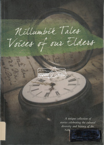
Book, Nillumbik Shire Council, Nillumbik tales : voices of our elders, 2014
On 4th October 2014 Nillumbik Shire Council launched a publication titled ‘Nillumbik Tales - Voices of our Elders’, which is a collection of colourful and personal snapshots of our local community. The unique Nillumbik based stories have been written by a variety of authors, including some who are members of our Society. In collating and publishing this historically important collection Nillumbik Shire Council has documented many aspects of our area and of the people who contributed to our community. The original print run of ‘Nillumbik Tales’ was sold out and there has been a reprint.Catalogue labels on spine and cover from Yarra Plenty Regional Library. Electronic ID label (RFID tag) inside rear covergardens, school, family, characters, organisations, place, local history, kangaroo ground, kinglake, nillumbik, bend of islands, eltham, cave, reminscences -
 Eltham District Historical Society Inc
Photograph, Tess Justine (Nillumbik Shire Council), Murray's Bridge over the Diamond Creek, Eltham North, 19 Feb 2022
Murray's Bridge over the Diamond Creek on the Diamond Creek Trail just prior to demolition and replacement with a new steel bridge. Heritage advice obtained by Nillumbik Shire Council, following a suggestion by the Eltham District Historical Society (EDHS), is that the original bridge appears to have been a simplified version of the Country Roads Board’s (CRB) standard timber bridge design of the early-to-mid 1920s. In c1990 Murray’s bridge was renovated with three recycled steel girders as part of a bike/pedestrian path in the reserve. During these alterations many parts of the bridge were removed, and some were replaced. Heritage advice indicates the condition of Murray’s bridge is poor. The remaining original parts are all in poor condition, with severe weathering, splitting and rot, especially to the stringers retained on the bridge. Heritage advice is that Murray’s Bridge does not have sufficient significance in the cultural history of the Nillumbik area to warrant inclusion in the Nillumbik Shire Heritage Overlay and also does not have sufficient significance as a rare survivor to warrant inclusion in the Nillumbik Shire Heritage Overlay. There are no indications in the historical record that this site was individually important to the cultural history of this area. EDHS is comfortable with the heritage advice provided to Council and has worked closely on this project with Council. EDHS has suggested some of the removed timbers be used in the vicinity of the bridge for landscaping and possibly seating, so as to retain these remnants close to the site of the original bridge, which is the last old timber bridge along the lower reaches of the Diamond Creek. Mary (Sweeney) Murray and John Wright Murray selected 80 acres, Lot C Section 16 and Lot 5 Section 17 Parish of Nillumbik, under an occupation license in 1866. John died in 1867 and freehold was granted to his son John in 1873. The farm was known as ‘Laurel Hill’. John Junior was an Eltham Shire councillor and sometime president from 1887 up until 1897. He added Lot A Section 16 to the farm in ca1888. John and his younger brother James arranged to rent/purchase Lot B Section 17, across Diamond Creek to the west, in ca1900. It appears that John and James farmed separately for a few years, with a new homestead built for James ad family on the high point of Lot B Section 17 in ca1910. John sold off Lot 5 Section 17 in 1912. When John died in 1912 James took over the land on both sides of the Diamond Creek. The old homestead on the west side of the Creek disappeared. A farm bridge over Diamond Creek from this period may have been located close to the northern boundary of the farm. John Langlands, owner of the farm known as ‘Ihurst’ on the west side of Diamond Creek to the south of the Murray’s land, died in 1907. In 1909 his land was then subdivided into 100 lots to become the ‘Glen Park Estate’. Other similar subdivisions of nineteenth century farms around Eltham in this period included the ‘Franktonia (or Beard’s) Estate’ to the northeast and ‘Bonsack’s Estate’ between Eltham and Greensborough. Soon after the opening of the railway extension line from Eltham to Hurstbridge in 1912, Glen Park and nearby residents including James Murray agitated for a railway station or siding to be located half-way between Eltham and Hurstbridge, so that the Glen Park residents who used the railway daily did not have to walk into the Eltham or Hurstbridge stations. Some believed Coleman’s Corner (opposite Edendale Farm) was an appropriate spot for the platform. James Murray was among those who thought the railway should be located on his land, closer to half-way between Eltham and Hurstbridge stations. The Railways Commissioners warned that the locals would have to fund these works themselves. The Glen Park Estate residents initially had difficulty accessing Eltham by road, with only an old low-level bridge over Diamond Creek at the south end of their estate. A new timber trestle bridge across the creek, now on Wattletree Road, was opened in 1915. Road access to the north was gained in 1927 when the new Murray’s Road, which crossed the Murray’s land, was built. Residents continued to agitate for a Glen Park station. By 1926 the Railways Commissioners’ preferred site was on the Murray’s land. They arranged an estimate of cost of a full-length platform. The estimate was too much for the locals, who in 1928 argued unsuccessfully for a shorter and hence cheaper platform. By 1929 Murray had agreed to donate the land, but the locals would still have to fund the works. Murray decided, unilaterally it would appear, to commence work on a timber trestle road bridge over Diamond Creek to link the new Murray Road to the proposed station. Late in 1929 he stopped work on the bridge, for reasons unknown, but started work again and completed the bridge in 1931. There is no further newspaper evidence of the campaign for the Glen Park station until 1939, when Murray and another local, Mr Maxwell, met the Railways Commissioner. The Glen Park locale now included 45 homes on the west side of the creek and 20 on the Eltham side. Most of the residents used the train every day. The Commissioner remained adamant that only a full-length platform could be built for safety reasons. It appears the campaign dissolved at this point. The increasing move to cars may have had an impact. There is no evidence of Murray’s bridge ever being connected to Murray’s Road, or of it having wide use for any purpose by locals. James Murray died in 1947 and the farm was taken over by his son James (Jim). Jim started to sell off parts of the farm in the 1980s, retaining a few acres around the ca1910 homestead and building a new house there. Recreation reserves were established along the creek. In ca1990 Murray’s bridge was renovated with steel girders as part of a bike/pedestrian path in the reserve. The old farmhouse was demolished in ca2014. * * * A theory posted on local community Facebook groups was that the bridge was built in the 1860s and was built to be more robust than was necessary for the movement of cows from one side of the creek to the other. It was suggested the robustness was necessary to support the weight of gold ore being transferred from a mine on Murray’s land to a railway siding near Murrays Bridge (presumably for transfer and processing at Diamond Creek). Perhaps this may have been one of the motivators for Murray, who really knows? Knowing when mining operations ceased on his land and how that fits the overall timeline would be useful but at the time the bridge was built, local gold production was minimal at best. The known facts are: • The railway line came to Eltham in 1902. • The extension of the railway from Eltham to Hurstbridge was constructed in 1912 so no railway line even existed through Murray's property until 1912 and the Victorian Railways maps at the time show no such siding on Murray’s property. • In 1923 a new company was formed in anticipation of the old Diamond Creek Gold Mine being re-opened. The mine had been previously closed and flooded. It was noted in the press at the time that the mine was within a mile of the railway. Nothing really came of this. • Construction of Murrays Bridge was commenced by James Murray in early 1929 in anticipation of a proposed flag station being nominated on his land, but work ceased shortly afterwards. The proposed flag station was commonly referred to as Glen Park as the residents of the Glen Park Estate wanted Option 1, located near them with the platform adjacent to Colemans corner. This was probably never going to fly as it was virtually in eyesight of Eltham station. Allandale Road was the third option, but the Commissioners' preferred option was No. 2 - on Murray's property. • The Railway Commissioners were not going to finance any such station and the works had to be funded by private landowners and residents, hence Murray investing in this himself. • Murray recommenced work two years later and finished his bridge in 1931 but unfortunately for him, the proposed flag station never eventuated. The bluestone siding you reference may well have been built by Murray as part of the proposed station platform. • Up until then, apart from the Main Road bridge, which was washed away in 1924, virtually all local crossings over the Diamond Creek were low lying bridges – Kaylocks Bridge at Brougham Street, Diamond Street bridge, Glen Park Road bridge. It is expected that Murray also had a low-lying bridge to connect his land either side of the creek. These were all washed away or severely damaged multiple times in the 1920s. Lessons were learnt, and Murrays Bridge appears to have been built in accordance with Country Road Board standards of the time. Flood damage was ongoing, and even more recently constructed raised bridges kept getting washed away, e.g., the new Wattle Tree Road bridge in 1958 just months after completion. Murray’s bridge was reinforced with steel some 30 years ago presumably to provide additional floodwater resistance, given the history of bridges disappearing in floodwaters. • In March 1932 it was reported in the Advertiser that there were still some prospectors operating around Eltham North who apart from further scarring the face of the earth over the previous two years had gained significant experience but little gold - hardly a driving factor for constructing a dedicated railway siding and bridge to transfer gold ore. It is far more probable that James Murray was hoping to have the railway station located on his property and invested his money by building the bridge to lead to it as well as a station platform. Had the station eventuated, it may well have driven up the value of his land for subdivision and new housing estates like the Glen Park Estate. That did not eventuate. Whilst the bridge was indeed old (90 years), the core structure being completed in 1931, it had been modified substantially from original and hence had no significant historic value – i.e., it was not a representative example of its type, construction, and age. Given that the bridge was not worthy of saving, the Eltham District Historical Society with Council’s support, and the Eltham Woodworkers group endeavoured to see what suitable sized timbers were salvageable to fabricate a commemorative seat. Unfortunately, the experts at the Woodworkers group were unable to salvage any suitable length/width timbers to fabricate the seat due to the presence of rot. Last remaining wooden trestle bridge on the Diamond Creek Trail just prior to demolition and replacementBorn digital image (27)diamond creek (creek), diamond creek trail, murrays bridge, ‘laurel hill’, john wright murray, mary (sweeney) murra, john murray jnr, james murray, john langlands, ‘ihurst’, ‘glen park estate’, beard's estate, franktonia, bonsack's estate, glen park estate, glen park railway station -
 Eltham District Historical Society Inc
Photograph, Tess Justine (Nillumbik Shire Council), Construction work on replacement of Murray's Bridge over the Diamond Creek, Eltham North, 31 Mar 2022
Construction work on replacement of Murray's Bridge over the Diamond Creek on the Diamond Creek Trail Mary (Sweeney) Murray and John Wright Murray selected 80 acres, Lot C Section 16 and Lot 5 Section 17 Parish of Nillumbik, under an occupation license in 1866. John died in 1867 and freehold was granted to his son John in 1873. The farm was known as ‘Laurel Hill’. John Junior was an Eltham Shire councillor and sometime president from 1887 up until 1897. He added Lot A Section 16 to the farm in ca1888. John and his younger brother James arranged to rent/purchase Lot B Section 17, across Diamond Creek to the west, in ca1900. It appears that John and James farmed separately for a few years, with a new homestead built for James ad family on the high point of Lot B Section 17 in ca1910. John sold off Lot 5 Section 17 in 1912. When John died in 1912 James took over the land on both sides of the Diamond Creek. The old homestead on the west side of the Creek disappeared. A farm bridge over Diamond Creek from this period may have been located close to the northern boundary of the farm. John Langlands, owner of the farm known as ‘Ihurst’ on the west side of Diamond Creek to the south of the Murray’s land, died in 1907. In 1909 his land was then subdivided into 100 lots to become the ‘Glen Park Estate’. Other similar subdivisions of nineteenth century farms around Eltham in this period included the ‘Franktonia (or Beard’s) Estate’ to the northeast and ‘Bonsack’s Estate’ between Eltham and Greensborough. Soon after the opening of the railway extension line from Eltham to Hurstbridge in 1912, Glen Park and nearby residents including James Murray agitated for a railway station or siding to be located half-way between Eltham and Hurstbridge, so that the Glen Park residents who used the railway daily did not have to walk into the Eltham or Hurstbridge stations. Some believed Coleman’s Corner (opposite Edendale Farm) was an appropriate spot for the platform. James Murray was among those who thought the railway should be located on his land, closer to half-way between Eltham and Hurstbridge stations. The Railways Commissioners warned that the locals would have to fund these works themselves. The Glen Park Estate residents initially had difficulty accessing Eltham by road, with only an old low-level bridge over Diamond Creek at the south end of their estate. A new timber trestle bridge across the creek, now on Wattletree Road, was opened in 1915. Road access to the north was gained in 1927 when the new Murray’s Road, which crossed the Murray’s land, was built. Residents continued to agitate for a Glen Park station. By 1926 the Railways Commissioners’ preferred site was on the Murray’s land. They arranged an estimate of cost of a full-length platform. The estimate was too much for the locals, who in 1928 argued unsuccessfully for a shorter and hence cheaper platform. By 1929 Murray had agreed to donate the land, but the locals would still have to fund the works. Murray decided, unilaterally it would appear, to commence work on a timber trestle road bridge over Diamond Creek to link the new Murray Road to the proposed station. Late in 1929 he stopped work on the bridge, for reasons unknown, but started work again and completed the bridge in 1931. There is no further newspaper evidence of the campaign for the Glen Park station until 1939, when Murray and another local, Mr Maxwell, met the Railways Commissioner. The Glen Park locale now included 45 homes on the west side of the creek and 20 on the Eltham side. Most of the residents used the train every day. The Commissioner remained adamant that only a full-length platform could be built for safety reasons. It appears the campaign dissolved at this point. The increasing move to cars may have had an impact. There is no evidence of Murray’s bridge ever being connected to Murray’s Road, or of it having wide use for any purpose by locals. James Murray died in 1947 and the farm was taken over by his son James (Jim). Jim started to sell off parts of the farm in the 1980s, retaining a few acres around the ca1910 homestead and building a new house there. Recreation reserves were established along the creek. In ca1990 Murray’s bridge was renovated with steel girders as part of a bike/pedestrian path in the reserve. The old farmhouse was demolished in ca2014. Born digital image (5)diamond creek (creek), diamond creek trail, murrays bridge, ‘laurel hill’, john wright murray, mary (sweeney) murra, john murray jnr, james murray, john langlands, ‘ihurst’, ‘glen park estate’, beard's estate, franktonia, bonsack's estate, glen park estate, glen park railway station -
 Eltham District Historical Society Inc
Document, Nillumbik Shire Council, Information Bulletin, 1996 Nillumbik Festival, 8 Aug 1996
In 1996 the Eltham Festival was renamed the Nillumbik Festival, centred around Alistait Knox Park and the Rugby Oval. The theme for the 1996 Nillumbik Festival held 9-10 November 1996 was "Celebrating Our Lifestyle" Information bulletin issued by Nillumbik Shire Council addressing how community groups can be involved and interpretation of the festival's theme covering the Grand Parade, Stage performance and sporting displays and Stalls3 x A4 photocopy, various coloured papereltham community festival, eltham festival, 1996, nillumbik festival -
 Eltham District Historical Society Inc
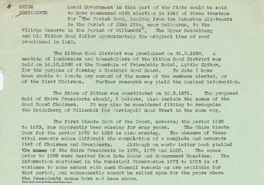
Document - Appendix, M.B. Watson, Shire Secretary, List of Former Road Board Chairmen and Shire Presidents (1856-1966), 28 Nov 1966
Appendix to Shire Secretary’s Report, 28 November 1966 SHIRE PRESIDENTS Local Government in this part of the State could be said to have commenced with election in 1846 of three trustees for "The Parish Road, leading from the Suburban Allotments in the Parish of Jika Jika, near Melbourne, to the Village Reserve in the Parish of Nillumbik". The Upper Heidelberg and Old Eltham Road follow approximately the original line of road proclaimed in 1840. The Eltham Road District was proclaimed on 24.9.1856. A meeting of landowners and householders of the Eltham Road District was held on 14.10.1856 at the Fountain of Friendship Hotel, Little Eltham, for the purpose of forming a District Road Board. To date I have been unable to locate any record of the names of the members elected, or of the first Chairman. Further research may yield the desired information. The Shire of Eltham was constituted on 28.3.1871. The proposed Roll of Shire Presidents should, I believe, also include the Road Board Chairmen. It may also be considered fitting to recognise the Heidelberg or Nillumbik (or Warringal) Road Trust in the same way. The first Minute Book of the Board, covering the period 1856 to 1863, has apparently been missing for many years. The Shire Minute Book for the period 1878 to 1885 is also missing. The absence of these vital records makes difficult the compilation of a complete and accurate list of Chairmen and Presidents. Although an early letter book yielded the names of the Shire Presidents in 1878, 1879 and 1800. The names prior to 1863 were derived from Rate Books and Government Gazettes. The information contained in the Municipal Directories 1875 to 1885 is at variance to some extent with such Council records as are available for that period, and consequently cannot be relied upon for the years where the Presidents names have not been shown. shire of eltham archives, series listing, a. armstrong, a. beale, a. brinkkotter, a. donaldson, a.h. price, a.j. braid, c.h. bath, c.m.a. pelling (mrs.), c.t. bell, d.c. o'beirne, e.d. butler, e.h. cameron, e.j. andrew, e.p. harmer, f.e. griffith, f.v. squire, f.w. nankervis, g. love, g. robertson, h. dendy, h. hewitt, h. stooke, l.t. wilmot, j. cox, j. murray, j. barr, j. bell, j. fitch, j. herbert, j. lawrey, j. mealy, j. pape, j. ryan, j. smedley, j.b. shallard, j.l. beale, l. c. docksey, r. mcadam, r.a. bell, r.c. white, r.r. woolcott, rutter, s.s. addison, s.w. scott, t. armstrong, t. irvine, w. horris, w. hubbard, w. lorimer, w. morris, w. taylor, w.c. farrell, w.f. ford, w.g. gray, w.h. bradbury, w.j. taylor, w.v. houghton -
 Eltham District Historical Society Inc
Film - Video (Digital), Geoff Paine, Eltham District Historical Society: Stories of the Nillumbik Shire with Geoff Paine, May 2020
One of a series of videos "Stories from the Nillumbik Shire with Geoff Paine" Features the Justice Precinct located at 728-730 Main Road Eltham made up of the former Police Residence (1859), replica Police Station (c.1989) and the former Eltham Courthouse (1860); home of the Eltham District Historical Society. President Jim Connor gives an overview of the history behind the establishment of the Courthouse and Police Residence, the beginnings of Little Eltham and the impact of the railway arriving in 1902. Also a potted history on the establishment of the historical society.MP4 Digital file 00:04:35; 260MBeltham courthouse, eltham district historical society, eltham justice precinct, geoff paine, jim connor, lock-up, police residence, police station, shillinglaw cottage, shillinglaw cottage preservation committee, shire of eltham historical society, video recording -
 Eltham District Historical Society Inc
Film - Video (Digital), Geoff Paine, Skipper Cottage: Stories of the Nillumbik Shire with Geoff Paine, June 2020
One of a series of videos "Stories from the Nillumbik Shire with Geoff Paine" A brief overview of the Skipper Cottage or Whitecloud and the Bootmakers cottage (mid 1850s) with Sue Thomas, partner of Adam Skipper who have lived there for about 40 years. Includes a view inside the Bootmaker's cottage. Discusses the flood plain and how the house was moved to its present site on high ground due to flooding. The high ground came about due to dumping of rubble from the quarry where the school car park is which was used to source stone to build the schoolhouse across the road. It was moved on horse and wagon approximately 200 metres. The cottage was previously a Cobb and Co stopping station for mail. When Montsalvat was being built in the 1940s, Lena Skipper who was originally from Sydney invested her money into buying Whitecloud rather than putting money into Montsalvat like many others. Upon her death, Matcham Skipper inherited the house. Seaweed was used as insulation in the ceiling and after Matcham owned it a spark from the fireplace set the seaweed on fire and gutted the front of the house which is now all one big room. Also illustrates some of the changes to the house over the years and its construction. The Elm forest has grown naturally from suckers spread from one tree.MP4 Digital file 00:05:50; 674MBvideo recording, bootmakers cottage, lena skipper, lena thomas, matcham skipper, school residence, skipper house, whitecloud cottage -
 Eltham District Historical Society Inc
Film - Video (Digital), Geoff Paine, St Margaret's Church, Eltham: Stories of the Nillumbik Shire with Geoff Paine, June 2020
One of a series of videos "Stories from the Nillumbik Shire with Geoff Paine" Geoff Sandy, Parish Historian and Archivist gives a history of the church which was opened 12 December 1861. It is constructed of polychrome bricks (lots of different colours). References a long relationship of over 159 years between the church committee and the Eltham Hotel across the road for refeshments for church events. The land was donated by Henry Dendy, the founder of Brighton where he lived for five years before going bankrupt and moving to Eltham where he bought a steam powered flour mill on the banks of the Diamond Creek at the end of Pitt Street. The church is heritage protected as well as the 1870 parsonage, Dendy House. It was always meant to be a much bigger church and extended along the north wall. This was finally achieved in 2014. Shows views inside of the original section and the extension. Also discusses the original tall windows on the south with gold trimming and other windows with gold trimming. Some original windows have been replaced by stained glass. Discussion about the Patron Saint of the Church, Margaret of Scotland. The original window made for £1 by Yuri and Fergusson in Melbourne and possibly one of the first made in the Colony of Victoria was relocated to the north wall during the 2014 extension. The crucifix was made by Matcham Skipper. Also features the Honour Roll. The walls of the extension are mudbrick, timber from a variety of sources and very much in keeping of the character of Eltham. The bell and bell tower are original. At the end of the First World War the bell was rung so vigorously that the bell broke.MP4 Digital file 00:05:48; 672MBvideo recording, church bell, dendy house, eltham, eltham hotel, flour mill, geoff sandy, henry dendy, honour roll, matcham skipper, mudbrick construction, pitt street, st margaret's anglican church, stained glass -
 Eltham District Historical Society Inc
Newspaper clipping, Program; Rotary Eltham Town Festival 19-20 November 2005, Diamond Valley Leader, 16 November 2005, p8, 2006
News articles on reverse (p7) include stories on Councillors refusing plans on a three-storey development in Ramptons RoadNewsprintdevelopment application, eltham festival, eltham north, nillumbik shire council, ramptons road, program -
 Eltham District Historical Society Inc
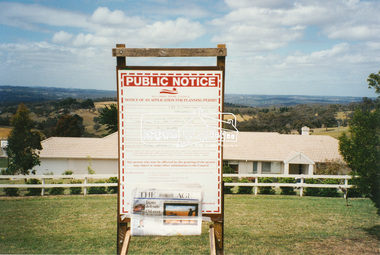
Negative - Photograph, Harry Gilham, Nillumbik Shire Council Notice of an Application for Planning Permit, 385 Eltham-Yarra Glen Road, Kangaroo Ground, 2002
Planning application 293/2002/06P by Harry Gilham for the Moor-rul viewing platform, road entrance revisions, earthworks and coach parking bays at the Shire of Eltham Memorial ParkRoll of 35mm colour negative film, 1 strip, 2 framesKodak Gold 200-6eltham-yarra glen road, kangaroo ground, moor-rul viewing platform, shire of eltham memorial park, harry gilham, nillumbik shire council, planning permit -
 Eltham District Historical Society Inc
Photograph, Harry Gilham, Nillumbik Shire Council Notice of an Application for Planning Permit, 385 Eltham-Yarra Glen Road, Kangaroo Ground, 2002
Planning application 293/2002/06P by Harry Gilham for the Moor-rul viewing platform, road entrance revisions, earthworks and coach parking bays at the Shire of Eltham Memorial ParkColur photo print (4)eltham-yarra glen road, kangaroo ground, moor-rul viewing platform, shire of eltham memorial park, harry gilham, nillumbik shire council, planning permit -
 Eltham District Historical Society Inc
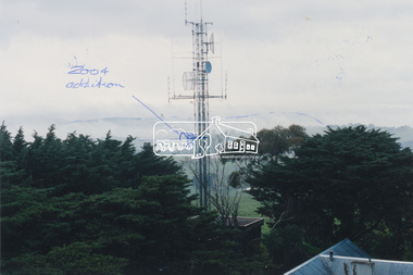
Photograph, View of communications tower from War Memorial tower, Kangaroo Ground, July 1998
Handwritten sketches showing additions to the Police/Emergency services communications tower in 2004. Harry Gilham noted that the cylindrical shaped object was blocking the view from the War Memorial tower to the land area and made suggestions to the Nillumbik Shire Council and CFA that it be raised to the sky area above the Mt St Leonard-Healesville range.Colour photo print 12.5 x 19 cmHandwritten notes on both sides regarding 2004 modificationskangaroo ground, shire of eltham memorial park, emergency services communications tower, harry gilham, nillumbik shire council, war memorial tower -
 Eltham District Historical Society Inc
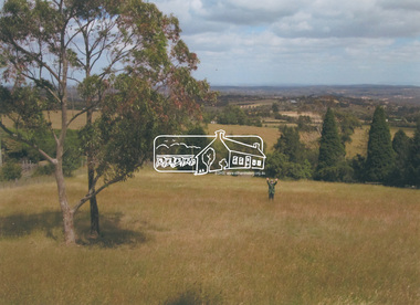
Photograph, Harry Gilham on field adjacent to Memorial Park, Kangaroo Ground, 2015
Harry Gilham standing in the field adjacent to the Memorial Park purchased by Eltham Shire Council in 1973 on the western side of the park. The Moor-rul Viewing Platform is behind the photographger's view. It was planned to utilise this field for improved access to the park and parkingColour photo inkjet print on glossy paper 15 x 21 cmkangaroo ground, shire of eltham memorial park, harry gilham, nillumbik shire council, moor-rul viewing platform -
 Eltham District Historical Society Inc
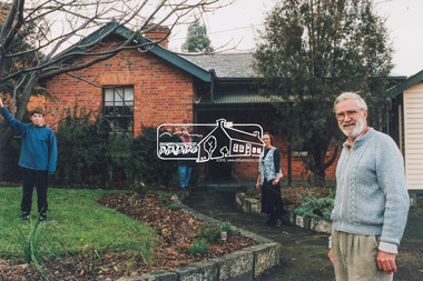
Photograph, Diamond Valley Leader, Eltham Local History Centre, former Police Residence, 728 Main Road, Eltham, 1998
Members of the Eltham District Historical Society transfer collection items from storage into their new home. Previously occupied by the Parks and Environment Department of Nillumbik Shire Council (L-R: Mark Gillham, Margaret Ball Vice President, Sue Law Immediate Past President, Harry Gilham President) Nillumbik Shire Council Commissioner Vin Heffernan (1996-97) worked with Harry Gilham to obtain use of the former Eltham Shire Parks and Gardens office at 728 Main Road for use by the Society. Harry as a younger man had played in the scrum for Heidelberg Football Club along with Vin's brother who was on the wing. Apparently Heffernan was able to access $30K to spend on the site to fix it up for occupation.Colour photo print 12.5 x 19 cmLeaser Newspaper Groupmargaret ball, mark gilham, police residence, sue law, 728 main road, activities, eltham, eltham district historical society, harry gilham, justice precinct, local history centre -
 Eltham District Historical Society Inc
Photograph, Jim Connor, Avenue of Honour, Main Road, Eltham, 14 Jan 2017
Eltham Gateway, Victorian Artists Supplies, 715 Main Rd, Eltham Victorian Artists Supplies was established in 1987 in this beautiful mud brick building. This small buisness supports the arts community of Eltham and the Shire of Nillumbik which flourishes through events such as Nillumbik Artists Open Studios.Tomorrow's history documented todayeltham, jim connor collection, main road, eltham gateway, avenue of honour, victorian artists supplies -
 Eltham District Historical Society Inc
Photograph, Jim Connor, Main Road, Eltham, 14 Jan 2017
Eltham Gateway, Living & Learning Nillumbik, 739 Main Road, Eltham Tomorrow's history documented todayeltham, jim connor collection, main road, eltham gateway, eltham living and learning centre -
 Eltham District Historical Society Inc
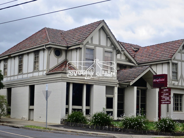
Photograph, Jim Connor, Main Road, Eltham, 14 Jan 2017
The Eltham Hotel is the oldest continually operating hotel in the Eltham district. Initially referred to as the Little Eltham Hotel, it has been known as the Eltham Hotel since the 1850s through to present time with a very brief period as the Eltham Tavern in the late 1980s. Benjamin Oliver Wallis was a prominent Eltham resident, publican and Councillor during the second half of the nineteenth century. He owned the house that is now the Nillumbik Living and Learning Centre at 739 Main Road Eltham and one stage the Eltham Hotel. Wallis migrated to Melbourne in 1853 but his wife and children remained in Cornwall for a further 10 years. Later in 1853 Richard Warren engaged Wallis to build the Eltham Hotel and it opened in 1854. The hotel was constructed of hard basaltic blue stone quarried in the Eltham district and cemented together with mud, and partly of bricks made at Eltham. The Fountain of Friendship Hotel on the opposite side of Maria Street (Main Road) opened shortly after. The hotel was a well-known resting place for gold diggers during the gold rush at Woods’ Point and Warren would buy the gold from the diggers. In 1858 Warren fell into financial difficulties and had to sell the hotel. Wallis bought the hotel and obtained a publican’s licence in 1861. In the 1850s the Fountain had been the more popular hotel but after that the Eltham Hotel became more popular. It is understood that in about 1857 Wallis probably built the “Living and Learning house” for tanner John Pearson. In 1868 Pearson became bankrupt and Wallis acquired the house and he lived there until his death in 1896. For some of this time the house was in the name of Benjamin’s son Richard but he died in 1888 and ownership reverted to his father. Wallis was a member of the Eltham Jockey Club and in 1867 his wife Anna rode her horse Charlotte in the Annual Races. Anna was also an angler and is reported to have caught a large perch in the Yarra River. She died in 1887. On 16th September 1886 Wallis sold the hotel to Christopher Watson (Snr). Watson died in 1887 and the hotel passed to his son Christopher Watson (Jr) who owned it until his death in 1909 at which time his wife Emily took over the license. Upon her death, their son Herbert applied for the license in January 1915. In July 1925, Herbert Watson demolished the original building and, in its place, erected a modern hotel which remains the foundation of the present Eltham Hotel. The contractors at the time commented on how well the original building had been constructed. A description of the new building was detailed in the Advertiser newspaper of January 8, 1926: “The new building consists of. two stories. designed in English tavern style, and contains-all told, 24 rooms. On the second floor, in front uninviting the two gables is a deep balcony, which will be much appreciated by visitors. The lower story is wholly of brick, and the upper one of wood and fibrous cement plaster. The rooms are spacious and lofty, and the windows are large and of latest style, and light the rooms splendidly. The entrance hall is 8 feet wide. The bar is a very commodious room and is furnished in the most up-to-date and convenient manner. The dining room, a very attractive apartment, is 30 feet by 15 feet 6 inches, and the bar parlor is also a large and well furnished room. A large cellar, an indispensable adjunct to an hotel, has been excavated beneath the bar. On the upper story are 12 bedrooms, and among other conveniences are two bath rooms in which hot and cold water can be used. All the rooms have been supplied with the necessary appliances for electric lighting, which will be one of the progressive evidences which Eltham will shortly enjoy.” “In the yard a brick garage to accommodate three cars at once, has been erected. This, as well as the hotel, is roofed with tiles.” “From the front of the hotel (especially the balcony) a lovely view of the country west and, north may be obtained.” “It may be added that it Is intended to have an ornamental garden, a tennis court. and a kiosk in connection with the hotel, and the property will have a rustic fence round it.” The hotel has since undergone several modifications and extensionsTomorrow's history documented todayeltham, jim connor collection, main road, eltham gateway, eltham hotel, pitt street -
 Eltham District Historical Society Inc
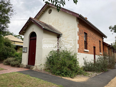
Photograph, Jim Connor, Avenue of Honour, Main Road, Eltham, 3 Apr 2021
Former Eltham Courthouse, 730 Main Road immediately prior to major restoration works undertaken by Nillumbik Shire Council. The Courthouse is the oldest public building in the shire. It was built in 1860 and ceased operations as part of the Court of Petty Sessions in 1985.Tomorrow's history documented todayeltham, jim connor collection, main road, eltham gateway, eltham courthouse, eltham justice precinct, avenue of honour -
 Eltham District Historical Society Inc
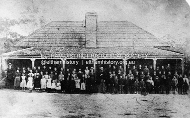
Negative - Photograph, Eltham State School No. 209, Dalton Street, Eltham, c.1990 (1864)
Negative copy of copy by Yeoman and Co. of original c.1864 photograph. The first Eltham State School building with school group. David Clarke (Head Teacher) and his sister, Catherine are standing in the centre of the group. Built with stone walls and wooden shingles on the roof. This was the first State School building which was built in 1856 and replaced with a new building in 1875 after the stone walls collapsed outwards. Published in Nillumbik Maii; Edition 20, 13 Sep Harry Gilham notes: - Believed to be the National School at Eltham on the Dalton Street site 1857-1874 - £220 cost; £110 National Board and £110 local patrons - 40' (38'6") x 16' x 10' walls - David Clark Head Teacher and Catherine Clark, Sewing Mistress - Its building materials came from the western edge of the site where sandstone removed is still evident and children are protected from the site by the fences of 1994 of wire mesh and palings beside the residence - School had 7' verandah added in 1861 - Clarks used half the building as a residence from 1857-1866 when enrollments required use of the whole building - The Clarks moved to then Shoestring residence in Metery Road adjacent to the end of the school ovalRoll of 35mm Black and White negative film, 3 strips, (2 of 14 frames)Film - Agfa Ortho 25catherine clarke, class photo, dalton street, david george clark, eltham, eltham state school no. 209, school group, national school -
 Eltham District Historical Society Inc
Slide - Photograph, 728 Main Road, cnr of Brougham Street, Eltham, May 1988, c.May 1988
728 Main Road, cnr of Brougham Street, Eltham, May 1988. Former Police House (1859) which at time of photo was the offices of the Shire of Eltham Parks and Environment. This photo was taken prior to the building of the replica Police Station to serve as a lunch room. The origional timber weatherboard building had been relocated around the rear of the residence years earlier but had since been demolished due to termite infestation. Ten years later (1998) the residence was made available by Nillumbik Shire Council for occupation by the Eltham District Historical Society (former Shire of Eltham Historical Society) to be used as their Local History Centre.35mm colour positive transparency (1 of 36) Mount - Kodak KodachromeProcess Date MAY 88Meltham, infrastructure, main road, brougham steet, eltham justice precinct, local history centre, parks and environment, police residence, shire of eltham -
 Eltham District Historical Society Inc
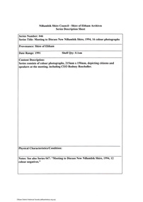
Document - Series Listing, Fraser Faithfull et al, Series 46: Meeting to Discuss New Nillumbik Shire, 1994, 16 colour photographs, 2000
Series consists of colour photographs, 215mm x 150mm, depicting citizens and speakers at the meeting, including CEO Rodney Roscholler.shire of eltham archives, series listing -
 Eltham District Historical Society Inc
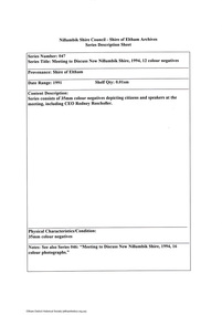
Document - Series Listing, Fraser Faithfull et al, Series 47: Meeting to Discuss New Nillumbik Shire, 1994, 12 colour negatives, 2000
Series consists of 35mm colour negatives depicting citizens and speakers at the meeting, including CEO Rodney Roscholler.shire of eltham archives, series listing -
 Eltham District Historical Society Inc
Document - Series Listing, Fraser Faithfull et al, Series 72: Shire of Eltham Alan Marshall Short Story Award and Presentation, photographs, 2000
27 colour snapshots taken on the occasion of the presentation of awards. The ceremony was conducted in the new Eltham Library. This was the final Shire of Eltham Alan Marshall Short Story Award. The presentation was held during the Nillumbik Shire Council period.shire of eltham archives, series listing -
 Eltham District Historical Society Inc
Document - Series Listing, Fraser Faithfull et al, Series 73: Shire of Eltham Alan Marshall Short Story Award and Presentation, photographic negatives, 2000
Series consists of 25 colour negatives taken on the occasion of the presentation of awards. The ceremony was conducted in the new Eltham Library. This was the final Shire of Eltham Alan Marshall Short Story Award. The presentation was held during the Nillumbik Shire Council period.shire of eltham archives, series listing -
 Eltham District Historical Society Inc
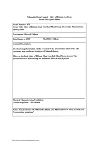
Slide, Motor Picnic, Kangaroo Ground, c.1920
Colour positive photograph taken c. Nov. 1974 of an original black and white print Indian Motor Bike, Dodge Car owned by Wraights of Kangaroo Ground (Nillumbik Historical Society)35 mm colour positive transparency Mount - Kodak Kodachrome CardProcessed Nov 1974kangaroo ground, motor picnic, motor vehicles, motorcycles, nillumbik historical society, picnic, vic registration 22115, wraight family -
 Eltham District Historical Society Inc
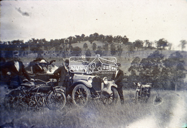
Slide, Indian Scout Motorbike owned by D. Wraight of Kangaroo Ground, c.1920
Colour positive photograph taken c. Nov. 1974 of an original black and white print Indian Motor Bike owned by D. Wraight of Kangaroo Ground (Nillumbik Historical Society)35 mm colour positive transparency Mount - Kodak Kodachrome CardProcessed Nov 1974d. wraight, indian scout, motorcycles, nillumbik historical society, vic registration 22506, kangaroo ground -
 Eltham District Historical Society Inc
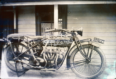
Slide, Fish caught in Yarra being shown outside Kangaroo Ground Hotel, c.1920
Colour positive photograph taken c. Nov. 1974 of an original black and white print (Nillumbik Historical Society)35 mm colour positive transparency Mount - Kodak Kodachrome CardProcessed Nov 1974fish, kangaroo ground, kangaroo ground hotel, nillumbik historical society -
 Eltham District Historical Society Inc
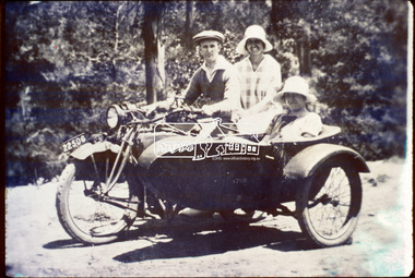
Slide, D. Wraight on his Indian Scout with sidecar, c.1920
Colour positive photograph taken c. Nov. 1974 of an original black and white print (Nillumbik Historical Society)35 mm colour positive transparency Mount - Kodak Kodachrome CardProcessed Nov 1974d. wraight, indian scout, kangaroo ground, motorcycles, nillumbik historical society, side-car, vic registration 22506 -
 Eltham District Historical Society Inc
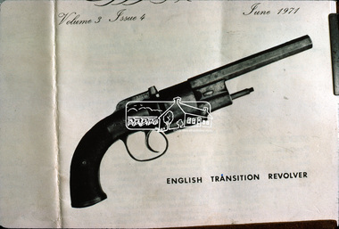
Slide, English Transition Revolver, c.1920
Colour positive photograph taken c. Dec. 1974 of an illustration (in a book?) dated June 1971 held by Nillumbik Historical Society. The illustration is of an English Transition Revolver, the same type of gun used by the Bushranger Burke to shoot and kill Henry Hurst in 186635 mm colour positive transparency Mount - Kodak Kodachrome CardProcessed Dec 1974burke, bushranger burke, english transition revolver, henry hurst, nillumbik historical society, pistol -
 Eltham District Historical Society Inc
Slide - Photograph, Shillinglaw Cottage, Eltham Common, Panther Place, Eltham, 27 May 1990
Local Cemetery Excursion Sunday 27 May 1990 departed Eltham Shire Office at 9.30am and finish mid afternoon. Visits to Eltham , Kangaroo Ground, Queenstown (Smiths Gully), Nillumbik (Diamond Creek), St Katherines (St Helena) Hurst family graves at Hurstbridge and a little known early cemetery at Grteensborough. Attended by 20 members. In each case we were introduced to the cemetery with a brief talk. At Eltham, Frank Burgoyne gave us the benefit of his knowledge as a member of the cemetery trust and at Kangaroo Ground, Bruce Ness spoke in a similar capacity. The lunch stop was at Hurstbridge where we visited the Hurst family graves. The President of Nillumbik Historical Society, Jock Ryan, joined us at the Nillumbik (Diamond Creek) cemetery. He travelled on to St Katherines, St Helena, where he talked on the history of the church and cemetery.35mm colour positive transparency (1 of 25) Mount - Kodak EktachromeProcessing Date Code Jun 90Mshillinglaw cottage, eltham common, panther place, eltham, activities, shire of eltham historical society, cemetery excursion