Showing 663 items
matching one pound
-
 Flagstaff Hill Maritime Museum and Village
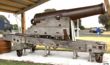
Weapon - Cannon, 1861
The artillery piece of the cannon was cast at the Low Moor foundry in England in 1861. It is a 68 pound muzzle loading cannon, capable of firing a 68 pound weight projectile. The arrow on the top of the barrel is the symbol of government ownership. It is probably one of the artillery pieces purchased by the Victorian government in response to the 1863 report by Captain Scratchley, which recommended 19 such artillery pieces be bought for the defence of Hobsons Bay, (Williamstown, Melbourne) (Billets p.12). It was possibly brought to Warrnambool in the late 1860s or the 1870s, to be used for training purposes by volunteers and local militia. The wrought iron runners were probably added to the slides at a later date. This model of carriage had been manufactured since 1855, and the traversing slide since 1860. The traversing slide of the wooden carriage absorbs the recoil when the gun is then returns to the gun to its original position for loading and re-firing. The properties of the timber (regarded as being Burmese teak) have helped to preserve these carriages in Australia. This particular carriage and traversing slide would have been manufactured about the same time as the gun (in 1861) in the Royal Carriage Department of the Royal Gun Factory in Woolwich, England. The gun would then have been assembled on the traversing slide of the carriage, then despatched as a unit. The wooden slide compressor mechanism that belongs to the cannon was used to limit the recoil when the cannon was fired. It is now stored separately for purposes of preservation. It is extremely rare, as it is the only one surviving in this group of South Western Victorian cannons.This 68 pdr cannon, mounted with its original wooden carriage, is part of the South Western Victoria collection of surviving 19th Century artillery pieces, item number W/F/02. It is rated as EXTREMELY RARE on a State, National and World level. The 68 pound smooth bore cannon of this period are not particularly rare either in Australia or overseas; its significance lies in its Victorian provenance and as an element in a major collection of 19th century cannon. The number of surviving carriages with traversing slides in this group in South Western Victoria is unique in Australia and probably in the World. Out of 10 such platforms surviving in Australia, the South Western Victorian group has half. Several survive around the world but probably not in such a large group. The wooden sliding compressor mechanism belonging to this cannon is extremely rare, and the only one in this South Western Victorian group of Guns and Cannons. As a whole, this cannon has undergone very little restoration or modification, giving it a high level of integrity.Warrnambool Garrison Cannon. 68pdr smoothbore, muzzle-loading, cast-iron cannon. Manufactured in Low Moor, 1861, No. 10310. Mounted on the wooden carriage with wrought iron traversing slide and wrought iron runners and fittings. The cannon's Cascabel is cast with a loop. The wooden slide Compressor Mechanism, or Recoil Mechanism, is extremely rare. This mechanism comprises two equal-sized sections of wood, one on each side of the centre, joined by metal rods. In the centre of this wooden platform, with openings, top and bottom is a 15cm diameter metal cylinder with two cusps on the edge of the top (this wood has split over time). Two parallel sides each have two 1cm thick metal "L' plates attached 15cm long and 8.5cm wide. With the unit is ‘ L’ bracket, curved bracket and bolt head.Cannon trunnion "LOW MOOR / 10310 / 1861" Top of the barrel "7045, (symbol of an arrow pointing up), 95 – 3 – 14, 1861, 209" Cascabel "CV / N / C" The rear of left-hand slide " "OD” “JW” “No 33” Side chock – “JW” twice. flagstaff hill, warrnambool, shipwrecked-coast, flagstaff-hill, flagstaff-hill-maritime-museum, maritime-museum, shipwreck-coast, flagstaff-hill-maritime-village, muzzle loading cannon, 68 pound cannon, low moor foundry, royal gun factory, warrnambool militia, warrnambool garrison volunteers, warrnambool fortifications, wooden sliding compression mechanism, carriage and traversing slide, 19th century cannon, traversing platform, garrison sliding carriage, 68 pounder -
 Flagstaff Hill Maritime Museum and Village
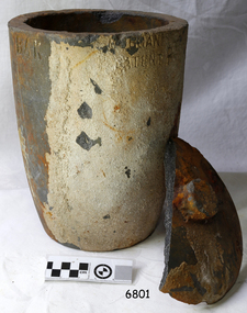
Functional object - Crucible, The Patent Plumbago Crucible Company, circa 1878
This crucible was raised from the wreck of the LOCH ARD. It is one of six similar relics, in a range of sizes, now in the Flagstaff Hill collection. All bear markings to indicate their manufacture by the Morgan brothers of Battersea, trading as the Patent Plumbago Crucible Co. A crucible is a container used for purifying and melting metals so that they can be cast in a mould to a predetermined shape and use. They must withstand extremely high temperatures, abrupt cooling, and shed their contents with minimal adherence. The addition of graphite to the traditional firing clays greatly enhanced the durability of industrial crucibles in mid-Victorian Britain, a significant technological advance at a time of great activity in foundries and expansion of demand for refined metals. The Morgans first noticed the advantages of graphite crucibles at the Great Exhibition held in London in 1851. Initially they contracted to be sole selling agents for the American-made products of Joseph Dixon and Co. from New Jersey, but in 1856 they obtained that firm’s manufacturing rights and began producing their own graphite crucibles from the South London site. The Morgans imported crystalline graphite in 4-5 cwt casks from the British colony of Ceylon (now Sri Lanka) and mixed it with conventional English (Stourbridge) clays to be fired in kilns. Their products were purchased by the Royal Mints in London and India, and exported to official mints in France and Germany. They were successful exhibitors of their crucibles and furnaces at the London Exhibition held in 1861 (Class 1, Mining, quarrying, metallurgy and mineral products, Exhibit 265, Patent Plumbago Crucible Co). The range of sizes represented by the six crucibles retrieved from the LOCH ARD, suggest they may have been part of a sample shipment intended for similar promotion in the Australian colonies ― at Melbourne’s International Exhibition to be held in 1880. The summary of cargo manifest, by Don Charlwood in ‘Wrecks and Reputations’ does not mention any crucibles, implying that they were not a large consignment of uniform items. A newspaper account of an 1864 tour of the Morgan brothers’ ‘Black Potteries’ at Battersea indicates: “All the pots were numbered according to their contents, each number standing for one kilogram, or a little over two pounds; a No. 2 crucible contains two kilogrammes; a No. 3, three kilogrammes, and so on.” These numbers are obscured by marine sediment on three of the crucibles in the Flagstaff Hill collection, but those legible on the remaining three are 5, 6, and 8. None of the six are of the same size from a visual appraisal.The shipwreck of the LOCH ARD is of State significance ― Victorian Heritage Register S417A large crucible, or fluxing pot, for heating and pouring molten metal. It was recovered from the wreck of the LOCH ARD. The clay fired vessel rises from circular flat base to a larger rim with pouring lip. It is stained a rust colour and bears some sedimentary accretion. Half of its loose fitting lid with central knob has also survived. Markings on the artefact indicate it is a Morgan’s crucible, made with graphite to prevent cracking in the furnace and provide a smooth (non-adhesive) inner surface. On base: “…RGAN’S PATENT CRUCIBLE”. On rim: “MORGAN’S PATENT P…” Below top edge "BAK"flagstaff hill, warrnambool, shipwrecked-coast, flagstaff-hill, flagstaff-hill-maritime-museum, maritime-museum, shipwreck-coast, flagstaff-hill-maritime-village, graphite crucible, plumbago crucible, morgans crucible company, loch ard, fluxing pot, crucible -
 Flagstaff Hill Maritime Museum and Village
Functional object - Crucible, The Patent Plumbago Crucible Company, circa 1873
This crucible was raised from the wreck of the Loch Ard. It is one of six similar relics, in a range of sizes, now in the Flagstaff Hill collection. All were manufactured by the Morgan brothers who founded the Patent Plumbago Crucible Company in 1856, making crucibles in a small factory in Battersea London. A crucible is a container used for purifying and melting metals so that they can be cast in a mold to a predetermined shape and use. They must withstand extremely high temperatures, abrupt cooling, and shed their contents with minimal adherence. The addition of graphite to the traditional firing clays greatly enhanced the durability of industrial crucibles this technique was pioneered by the Morgan Bros thereby making a significant technological advance in foundry technology and metallurgy. The Morgans first noticed the advantages of graphite crucibles at the Great Exhibition held in London in 1851. Initially, they contracted to be sole selling agents for the American-made products of Joseph Dixon and Co. from New Jersey, but in 1856 they obtained that firm's manufacturing rights and began producing their graphite crucibles from the South London site. The Morgans imported crystalline graphite in 4-5 cwt casks from the British colony of Ceylon (now Sri Lanka) and mixed it with conventional English (Stourbridge) clays to be fired in kilns. Their products were purchased by the Royal Mints in London and India and exported to official mints in France and Germany. They were successful exhibitors of their crucibles and furnaces at the London Exhibition held in 1861 (Class 1, Mining, quarrying, metallurgy and mineral products, Exhibit 265, Patent Plumbago Crucible Co). The range of sizes represented by the six crucibles retrieved from the Loch Ard suggests they may have been part of a sample shipment intended for similar promotion in the Australian colonies or at Melbourne's International Exhibition to be held in 1880. A newspaper account of an 1864 tour of the Morgan brothers' 'Black Potteries' at Battersea indicates: "All the pots were numbered according to their contents, each number standing for one kilogram, or a little over two pounds; a No. 2 crucible contains two kilograms; a No. 3, three kilograms, and so on." These numbers are obscured by marine sediment on three of the crucibles in the Flagstaff Hill collection, but those legible on the remaining three are 5, 6, and 8. None of the six is of the same size. (For more information on the Loch Ard wreck see note sec this document) The shipwreck of the Loch Ard is of significance for Victoria and is registered on the Victorian Heritage Register ( S 417). Flagstaff Hill has a varied collection of artefacts from Loch Ard and its collection is significant for being one of the largest accumulation of artefacts from this notable Victorian shipwreck of which the crucible is a small part. The collections objects give us a snapshot of how we can interpret the story of this tragic event. The collection is also archaeologically significant as it represents aspects of Victoria's shipping history that allows us to interpret Victoria's social and historical themes of the time. Through is associated with the worst and best-known shipwreck in Victoria's history.A medium size crucible, or fluxing pot, for heating and pouring molten metal. The container rises in a slight curve from a smaller flat base to a wider open top with a lip for pouring. It was recovered from the wreck of the LOCH ARD. The crucible has a coating of sediment that obscures its numerical specifications of size and capacity. The markings that remain visible indicate it is a Morgan’s crucible, made with graphite to prevent cracking and provide a smooth non-adhesive inner surface. .On base: “…ORGAN’S …ENT”flagstaff hill, warrnambool, flagstaff-hill-maritime-museum, shipwreck-coast, flagstaff-hill-maritime-village, graphite crucible, plumbago crucible, morgan's crucible company, loch ard, morgan potteries, crucible, fluxing pot -
 Flagstaff Hill Maritime Museum and Village
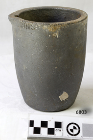
Functional object - Crucible, The Patent Plumbago Crucible Company, circa 1878
This crucible was raised from the wreck of the LOCH ARD. It is one of six similar relics, in a range of sizes, now in the Flagstaff Hill collection. All bear markings to indicate their manufacture by the Morgan brothers of Battersea, trading as the Patent Plumbago Crucible Co. A crucible is a container used for purifying and melting metals so that they can be cast in a mould to a predetermined shape and use. They must withstand extremely high temperatures, abrupt cooling, and shed their contents with minimal adherence. The addition of graphite to the traditional firing clays greatly enhanced the durability of industrial crucibles in mid-Victorian Britain, a significant technological advance at a time of great activity and expansion in foundries and demand for refined metals. The Morgans first noticed the advantages of graphite crucibles at the Great Exhibition held in London in 1851. Initially they contracted to be sole selling agents for the American-made products of Joseph Dixon and Co. from New Jersey, but in 1856 they obtained that firm’s manufacturing rights and began producing their own graphite crucibles from the South London site. The Morgans imported crystalline graphite in 4-5 cwt casks from the British colony of Ceylon (now Sri Lanka) and mixed it with conventional English (Stourbridge) clays to be fired in kilns. Their products were purchased by the Royal Mints in London and India, and exported to official mints in France and Germany. They were successful exhibitors of their crucibles and furnaces at the London Exhibition held in 1861 (Class 1, Mining, quarrying, metallurgy and mineral products, Exhibit 265, Patent Plumbago Crucible Co). The range of sizes represented by the six crucibles retrieved from the LOCH ARD, suggest they may have been part of a sample shipment intended for similar promotion in the Australian colonies ― at Melbourne’s International Exhibition to be held in 1880. A summary of the LOCH ARD cargo manifest, by Don Charlwood in ‘Wrecks and Reputations’ does not mention any crucibles, implying that they were not part of a larger consignment of uniform items. A newspaper account of an 1864 tour of the Morgan brothers’ ‘Black Potteries’ at Battersea indicates: “All the pots were numbered according to their contents, each number standing for one kilogram, or a little over two pounds; a No. 2 crucible contains two kilogrammes; a No. 3, three kilogrammes, and so on.” These numbers are obscured by marine sediment on three of the crucibles in the Flagstaff Hill collection, but those legible on the remaining three are 5, 6, and 8. None of the six are of the same size from a visual appraisal. The shipwreck of the LOCH ARD is of State significance ― Victorian Heritage Register S417A No. 6 size Morgan’s graphite crucible (i.e. 6kgs capacity). The crucible rises in a slight curve from a smaller flat base up to a wider top with a (chipped) pouring lip. It was recovered from the wreck of the LOCH ARD. The artefact is largely accretion free despite its long period of submersion at the wreck site. It has a number of visible maker’s markings which identify the manufacturer and the smelting capacity of the pot. The graphite crucible is in fair and stable condition. The number “6” which is framed in a square. The letters “THE PATENT PLUMBAGO CRUCIBLE COMPANY” and “BATTERSEA WORKS COMPANY”. Below rim "... GNS"flagstaff hill, warrnambool, shipwrecked-coast, flagstaff-hill, flagstaff-hill-maritime-museum, maritime-museum, shipwreck-coast, flagstaff-hill-maritime-village, graphite crucible, plumbago crucible, morgan's crucible company, loch ard, crucible, fluxing pot -
 Phillip Island and District Historical Society Inc.
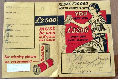
Photograph Folder, Kodak, Kodak Photograph & negative Folder
... pound with one simple snapshot.... pound world competition. You may win 3300 pound with one simple ...Light cardboard folder in mainly mustard colour with woman on cover. Opens to hold pockets for negatives and printed photosKodak 20,000 pound world competition. You may win 3300 pound with one simple snapshot.phpotograph folder, kodak -
 Phillip Island and District Historical Society Inc.
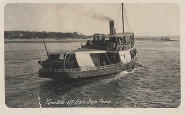
Photograph - Post Card, circa 1927
One of two photographs donated by Ken PoundBlack & White photograph of the Steam Ferry "Genista" off from San Remo. Newhaven and pier in the background."Genista" off from San Remogenista, ss genista, san remo, phillip island, ken pound -
 Phillip Island and District Historical Society Inc.
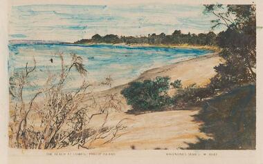
Photograph - Post Card, circh 1927
One of two photographs donated by Ken PoundColoured postcard of a windswept Cowes beach. Looks like a photograph of a painting."The Beach at Cowes, Phillip Island" Valentine's Series M 4847cowes beach, phillip island, ken pound -
 Greensborough Historical Society
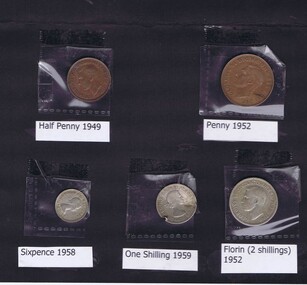
Coin - Coins, Royal Australian Mint, Pre-Decimal coins, 1949-1959
5 pre-decimal coins: half penny (1949), penny (1952), sixpence (1958), one shilling, damaged (1959) and florin (2 shillings) (1952).In 1966, Australian currency changed from sterling (pounds, shillings and pence) to decimal (dollars and cents). 5 coins, in black folder with contents listed on cover.currency, coins, pre-decimal coins, australian coins -
 Mission to Seafarers Victoria
Letter - Correspondence, 31/01/1951
Indicates a friendship at the timeQuinn CollectionFive page letter (0857.a1-5) written to Allan in black ink on pale brown paper headed Alfred Wolff, c/- Gilbert, 41 Kensington Road, Melbourne S.E.1. Port Adelaide 31/01/51. Airmail envelope (0857.b) has been re- addressed from C/- Australia House, The Strand, London, England to General Delivery G.P.O. Oslo, Norway. The post-mark, only partly legible, is South Australia and the value of the Australian stamp one shilling and sixpence. On the back of the envelope is a promotional stamp for 'British Industries Fair, 30 April - 11 May 1951, London & Birmingham'. Also a London postmark, an Oslo postmark and a return address as per the heading on the letter with 'South Yarra' substituted for 'Melbourne'.Letter commences "Dear Al,...." and concludes "...your pal Fred". This letter is in reply to a letter from Allan and contains descriptions of life as a crew member on board a Swedish ship. The writer comments on how much prices have increased in Australia in the last twelve months and lists various items (clothing, hair cuts, cigarettes) and their prices. A 1950 Buick is being sold for 3,500 pounds, a 1950 Plymouth for 3,200 pounds and a 1950 Ford for 2,900 pounds. Holden cars sell for about 1,300 pounds.letters-from-abroad, quinn, 1951, alfred wolff -
Mission to Seafarers Victoria
Letter - Correspondence, 20/04/1951
Letter commences "My Dear Old Pal,.." and concludes "...all the very best, Frank". He mentions the cost of living; Royal Doulton crockery set nineteen pounds, bedroom suite and lounge one hundred and ninety-five pounds, rent for a house " a modern place situated in a very nice area" three guineas a week. Also that the choice at the moment "... is 'Pig Iron Bob' or 'Old Man Chifley'..".Quinn CollectionA four-page letter written on four sheets of lined, buff coloured paper (0867.a1-4) headed Mr O F Mauhews, 101 Whatley Crescent, Bayswater, Western Australia and dated 20/04/51. The matching envelope (0867.b) is addressed to Mr Allan Quinn, C/- General Delivery, G.P.O. Oslo, Norway. The stamps, most of the post-mark and the last letter of 'Quinn' have been torn off. On the back of the envelope is an Oslo post-mark dated '2-5.51'. The date 22/4/51 and the return address for Mr Mauhews is written diagonally across the bottom right hand corner.letters-from-abroad, allan quinn, o. f. mauhews (frank) -
 Montmorency–Eltham RSL Sub Branch
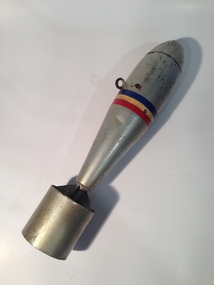
Weapon - Bomb, Aerial Practice
The 11 Pound Practice Bomb was used in Australia to train air crews both during and after WW2. When the bomb hit the ground it produced a smoke cloud so that the aircrew could see where their bomb had landed. There was only a small explosive charge in them. Cylindrical, finned steel bomb weighing approx. 11lb painted silver with three stripes (blue, yellow, red) painted around the mid-section. One attachment point/loop. Cast iron nose. None. -
 Montmorency–Eltham RSL Sub Branch
Weapon - 6-Pounder Shell Case, E.C.C, 1942
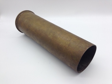
The Ordnance QF 6-pounder (57mm) 7 cwt was a British anti-tank gun used by both British and Commonwealth forces during World War II. Different versions of the gun were used on tanks, armoured cars and naval vessels. One version - the Molins Gun - was even used on an aircraft. Designed to replace the QF 2-pounder (40mm) it was first used by Australian troops during the El Alamein battles in 1942. The guns were also made in Australia by General Motors Holden who produced 615 of them, delivering the first gun in July 1942. The United States Army also adopted it and called it the 57mm Gun M1. Ammunition was primarily armour-piercing but in March 1944 a high-explosive round was introduced. The shell case shown here would have contained a 2.86kg (6lb 5oz) armour-piercing projectile. Brass Shell CaseOn Base of Cartridge: 6PR 7CWT LOT E.C.C. 236 On central firing disc: No. 15 II 11C 41 115 TH 1- -42 7 1942 F. T -
 Phillip Island and District Historical Society Inc.
weapon, Cannon Balls, Prior to 1826
One of three Cannon Balls found c1920 on the north side of Rhyll by Oswald Underdown. It is presumed to be from the 1826 British battery Fort Dumaresq. This together with the settlement near Corinella was set up to deter the French from taking possession of the area.Cannon ball, black cast iron, minor rusting - one of three. fort dumaresq, cannon, samuel wright, 3 pound cannon ball, oswald underdown -
 Phillip Island and District Historical Society Inc.
Photograph, 1935
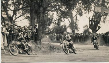
One of a collection of over 400 photographs in an album commenced in 1960 and presented to the Phillip Island & Westernport Historical Society by the Shire of Phillip Island The race in this photograph was the Australian Junior Tourist Trophy race over 75 miles/12 laps. The winner, Cec Weatherby received 20 pounds prize money and a sash. The race was run concurrectly with the Lightweight race, which was common back then. Peter Shannon's brother has the actual bike that came 3rd in that 1935 Lightweight race.Photograph of C. Weatherby leading other Motor Cyclists rounding "Tin Pot Corner" in a Motor Cycle Race in 1935. Corrections to the above given by Peter Shannon 2/11/2018. No. 11 was Don Bain actually leading the group, who came 3rd, No. 64 was Cec Weatherby who won the race and No. 25 was Ron Walters who came 4th. The Flyer was also given to us by Peter Shannon.local history, photography, motor cycle race, black & white photograph, sport, motor cycle racing, "tin pot corner", c weatherby, john jenner, bryant west -
 Phillip Island and District Historical Society Inc.
Photograph, 1959
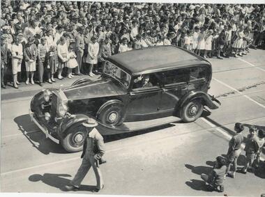
One of a collection of over 400 photographs in an album commenced in 1960 and presented to the Phillip Island & Westernport Historical Society by the Shire of Phillip IslandPhotograph of Rolls Royce car in the 1959 Moomba Parade. The car was stated to have cost 8,000 pounds in 1945, and was used on the set for filming part of "On the Beach" in 1959 at Cowes, Phillip Island. local history, photography, a rolls royce limousine, black & white photograph, motor transport, moomba, on the beach filming, john jenner, bryant west -
 Greensborough Historical Society
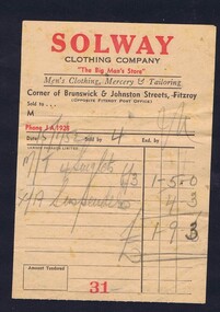
Receipt, Solway Clothing Company, Solway Clothing Company 1952, 15/01/1952
Receipt for purchase of four singlets and suspenders value pound 1/9/3 from Solway Clothing Company 15/1/1952.Printed on one side in red and black on white paperHand-written receipt.solway clothing compay, black family -
 Greensborough Historical Society
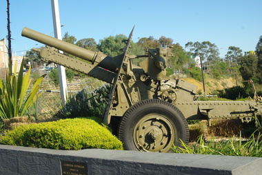
Photograph - Digital Image, Greensborough RSL - military hardware at entrance to RSL, 1940o
This photo shows the gun at the entrance to the Greensborough RSL (Main Street Greensborough). It is a 25 pounder gun-howitzer, the standard British field gun of WW2, introduced here from 1940. We used them in great numbers, right up to the 1960s, and even manufactured them here, hence why every RSL seems to have one. Digital copy of colour photograph.greensborough rsl -
 Greensborough Historical Society
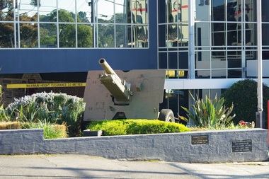
Photograph - Digital Image, Greensborough RSL - artillery piece at entrance to RSL 2, 1940o
This photo shows the artillery piece at the entrance to the Greensborough RSL (Main Street Greensborough). It is a Howitzer 25 pounder gun. It was the standard British field gun of WW2, introduced here from 1940. Australia used them in great numbers, right up to the 1960s, and even manufactured them here, hence why every RSL seems to have one. Digital copy of colour photograph.greensborough rsl -
 Halls Gap & Grampians Historical Society
Postcard - Sepia, C 1918
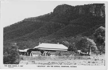
Bellfield' was a guest house during the period 1910-191924 Cabins provided additional accommodation for guests. One undated post card had the following words hand written on the reverse side: "Dear Florrie and William I expect you have worried not getting a line lately, it's such a job getting letters posted. This is the back of the house where I go to work. they had 43 boarders last week. 3 pounds each We had to work like niggers Im writing a letter to tell you all about it. With fond love Mary xxx"View of side of building with a number of cabins in foreground surrounded by a picket fence. The southern end of the Wonderland Range is in the background with sundial Peak being the predominant featureThe rose series P 1667 2 post cards and 1 photo of post card 1 original post card has message writtenaccommodation, guesthouses, bellfield -
 Halls Gap & Grampians Historical Society
Newspaper - Photocopy
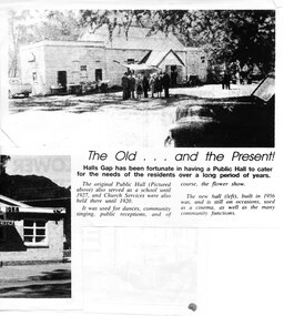
The article shows a photo of the original Hall's Gap Hall and the (then) new Hall, which was built in 1956. The copy has been scanned as two separate images (because it was too large for the scanner). the second image is stored under "Additional Images". HISTORY OF HALL'S GAP HALL: No village, no matter how small, could possibly survive without a public meeting place, and Hall's Gap was no exception, even in 1899-1900. Actually it was the locals of Stony Creek village, as Hall's Gap was known for a short time, who decided to hold a meeting to find out how much interest there was in building a town hall! They soon found out that support was overwhelming, as can be seen by the fact that 14 gentlemen nominated for a position on the committee of four! Several motions were moved at that meeting, mainly with reference to the materials to be used, for instance that no "wattle and daub", but rather slabs of bark and local bush logs be used. The walls were to be constructed of slabs, 6 feet long, 9 inches wide and two inches thick. Uprights were to be 9 feet high and at least 9 inches thick. Sheets of bark, all 32 of them, had to be 8 feet by 8 feet. Tenders for the building materials were called on 9 March 1899 and, 21 days later, McKeon Brothers won the right to supply all the material for the princely sum of 4 pounds 10 shillings. The size of the hall was to be 20 feet by 10 feet. The first hall served the community well for the next thirteen years, being regularly used as a place of entertainment and religious worship. The growing community soon realised the need for a larger venue, with better facilities, so once again the townsfolk rallied to raise funds for a new hall, realising their dream around 1913. In 1921 a schoolteacher was provided by the education department but as there was no school building she was expected to use the hall. Mainly lessons were held in the kitchen as it was much warmer than the hall itself, and it was not unusual for up to twenty children to be taught, ranging in age from 5 to 14 years. It was not until 1928 that an official school was built. 1955-56 were years of great excitement. The Progress Association was in charge of deciding the format for the new hall, and there were many rowdy meetings beforehand. Some members had much more vision than others, and to some the amount of money required seemed astronomical. Two hall committee members resigned over differences of opinion but amazingly it all came together in the end, albeit at a greater cost than had been anticipated. There is only one record of a grant being made for the building,1500 pounds, and it came for the Minister of Public Works. Estimated cost of the building was around 8,000 pounds, and when finally finished it was just slightly over, but bank charges and interest took it to well over 9,000 pounds. An electric light generator was included and lighting installed. The SEC electricity was connected in 1962.A copy of a newspaper article entitled 'The Old . . . and the Present!', which includes two photographs.buildings, halls -
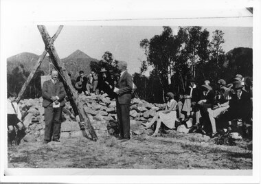 Halls Gap & Grampians Historical Society
Photograph - B/W, 14/04/1931
The photo shows the opening ceremony of Henham Township by Lord Stradbroke (the man on the right of the structure). A strip of land 2 kilometres long and half a kilometre wide had been approved as suitable for subdivision into 591 quarter acre blocks valued at 30-35 pounds each. Unfortunately it turned out to be a "fizzer". For further information see Victoria's Wonderland pp 93-95, 103.Photo shows a group of people sitting on and standing behind a low pile of rocks that sweeps around a wooden structure, which is three rough logs standing and lashed together to form a rough pyramid. A pulley is attached to the apex of the pyramid and a large stone block is suspended from it. Two men stand, one in front of and one beside the structure, both wear suits and are holding pieces of paper. A young boy sits in the left foreground in front of one of the poles.events, ceremonies -
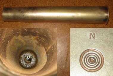 Friends of the Cerberus Inc
14 pounder Shell casing, circa 1888
A 14 pounder shell casing manufactured for the two prototype guns used by the Victorian Navy. Unlike the later Mk I and M II 14 pounders which used separate components the ammunition for the prototype guns was assembled into one fixed piece and crimped together.Only a handfull of these sheels are known to exist as later 14 pounder guns used separate shell casing and projectiles.Cylindrical shell casing made of brass.On base - "N"nordenfelt shell case, ammunition -
 Eltham District Historical Society Inc
Photograph, Upper Yarra Dam, Spring Tour, 22 Oct 1995, 22/10/1995
EXPLORING THE UPPER YARRA (Newsletter No. 105, November 1995, by Bettina Woodburn) We enjoyed the Spring Excursion, this year "Exploring the Upper Yarra" - in spite of the constant rain and the countryside under the cloud cover, especially in the valleys, being mainly shiny shades of green. The occasional fields of buttercups, clumps of arum lilies and splendid rhododendron and other flowering bushes became very special. The Cobb and Co coach was warm and a cosy retreat as we zig-zagged on the highways and byways to glimpse the Yarra River, upstream and down, its secret places, and particularly the many bridges. Russell excelled as 'Poet Laureate', reading from Dacre Smyth's book. This 1979 publication includes paintings of all the bridges along the river with poems and brief descriptions of each one. Some of the bridges are in out of the way places and are not very well known. We looked forward to hearing the poetry as much as seeing the ' constructions'…Big Pat (was he short or tall, lean or fat? He did win the two hundred pound reward for discovering gold and had the creek named after him), about the 'Eddies'?, and the disliked 'meccano' bridge in Warburton, etc. etc. The hot roast lunch in the old Reefton Hotel was also most welcome. It was easy to imagine it peopled by miners and early settlers. Starting by crossing the new (1974) concrete bridge at Warrandyte we headed through Wonga Park with views to the Christmas Hills and to the escarpment of the Yering Gorge, which causes flood waters to back up through the Yarra Glen plain, so avoiding disasters downstream. At the end of a long driveway we found the wooden, privately owned Henley Bridge (1935 after the 1934 floods). This facilitates access to different parts of Henley Farm and to Lilydale. Everard Park, named after Blanche Shallard's father, a State Member for 17 years, below the Highway Yarra crossing was in need of care. It is 10 miles from Yarra Glen by road but, as "Yarra Marra” canoeists well know, 32 winding miles down by water. After more delightful countryside scenes we joined the Warburton Highway at Woori Yallock. From the old Railway Station at Launching Place the Centennial Trail for walkers, cyclists and ' horse riders has replaced the rails. The line from Lilydale was opened in 1901, and the last diesel freight train ran to Warburton in 1965. It continued to rain as we had morning tea in Warburton in a shelter between footbridges. From here we continued upstream past the Bridge to O'Shannasy Lodge and Reservoir, Starvation Creek, and the Peninsular tunnel (miners dug it as at Pound Bend) which we visited (scrambling down those steps!) on our return after lunch. Our furthermost point was the Upper Yarra Dam Reserve (and vast catchment area). Finished in 1957 after ten years work and 100 years after Yan Yean, it supplies much of Melbourne's water. After crossing the 30m Launching Place Bridge to the Eltham side of the Yarra and Healesville, we saw in the distance the Yarra Glen Timber Trestle Bridge over the river flats "the longest for years in the land it was said!" Harry's dream of "better weather over the Divide" unfortunately didn't come true, but I'm sure we 36 members will retain happy memories of a day that was wet and green and filled with Bridges. Bettina Woodburn - October 1995 Record of the Society's history of activities - Spring 1995 excursionRoll of 35mm colour negative film, 3 stripsKodak Gold 200-4shire of eltham historical society, activities, upper yarra dam, henley bridge -
 Eltham District Historical Society Inc
Photograph, Upper Yarra Dam, Spring Tour, 22 Oct 1995, 22/10/1995
EXPLORING THE UPPER YARRA (Newsletter No. 105, November 1995, by Bettina Woodburn) We enjoyed the Spring Excursion, this year "Exploring the Upper Yarra" - in spite of the constant rain and the countryside under the cloud cover, especially in the valleys, being mainly shiny shades of green. The occasional fields of buttercups, clumps of arum lilies and splendid rhododendron and other flowering bushes became very special. The Cobb and Co coach was warm and a cosy retreat as we zig-zagged on the highways and byways to glimpse the Yarra River, upstream and down, its secret places, and particularly the many bridges. Russell excelled as 'Poet Laureate', reading from Dacre Smyth's book. This 1979 publication includes paintings of all the bridges along the river with poems and brief descriptions of each one. Some of the bridges are in out of the way places and are not very well known. We looked forward to hearing the poetry as much as seeing the ' constructions'…Big Pat (was he short or tall, lean or fat? He did win the two hundred pound reward for discovering gold and had the creek named after him), about the 'Eddies'?, and the disliked 'meccano' bridge in Warburton, etc. etc. The hot roast lunch in the old Reefton Hotel was also most welcome. It was easy to imagine it peopled by miners and early settlers. Starting by crossing the new (1974) concrete bridge at Warrandyte we headed through Wonga Park with views to the Christmas Hills and to the escarpment of the Yering Gorge, which causes flood waters to back up through the Yarra Glen plain, so avoiding disasters downstream. At the end of a long driveway we found the wooden, privately owned Henley Bridge (1935 after the 1934 floods). This facilitates access to different parts of Henley Farm and to Lilydale. Everard Park, named after Blanche Shallard's father, a State Member for 17 years, below the Highway Yarra crossing was in need of care. It is 10 miles from Yarra Glen by road but, as "Yarra Marra” canoeists well know, 32 winding miles down by water. After more delightful countryside scenes we joined the Warburton Highway at Woori Yallock. From the old Railway Station at Launching Place the Centennial Trail for walkers, cyclists and ' horse riders has replaced the rails. The line from Lilydale was opened in 1901, and the last diesel freight train ran to Warburton in 1965. It continued to rain as we had morning tea in Warburton in a shelter between footbridges. From here we continued upstream past the Bridge to O'Shannasy Lodge and Reservoir, Starvation Creek, and the Peninsular tunnel (miners dug it as at Pound Bend) which we visited (scrambling down those steps!) on our return after lunch. Our furthermost point was the Upper Yarra Dam Reserve (and vast catchment area). Finished in 1957 after ten years work and 100 years after Yan Yean, it supplies much of Melbourne's water. After crossing the 30m Launching Place Bridge to the Eltham side of the Yarra and Healesville, we saw in the distance the Yarra Glen Timber Trestle Bridge over the river flats "the longest for years in the land it was said!" Harry's dream of "better weather over the Divide" unfortunately didn't come true, but I'm sure we 36 members will retain happy memories of a day that was wet and green and filled with Bridges. Bettina Woodburn - October 1995 Record of the Society's history of activities - Spring 1995 excursionRoll of 35mm colour negative film, 2 stripsKodak Gold 100-4shire of eltham historical society, activities, upper yarra dam, henley bridge -
 Eltham District Historical Society Inc
Photograph, Upper Yarra Dam, Spring Tour, 22 Oct 1995, 22/10/1995
EXPLORING THE UPPER YARRA (Newsletter No. 105, November 1995, by Bettina Woodburn) We enjoyed the Spring Excursion, this year "Exploring the Upper Yarra" - in spite of the constant rain and the countryside under the cloud cover, especially in the valleys, being mainly shiny shades of green. The occasional fields of buttercups, clumps of arum lilies and splendid rhododendron and other flowering bushes became very special. The Cobb and Co coach was warm and a cosy retreat as we zig-zagged on the highways and byways to glimpse the Yarra River, upstream and down, its secret places, and particularly the many bridges. Russell excelled as 'Poet Laureate', reading from Dacre Smyth's book. This 1979 publication includes paintings of all the bridges along the river with poems and brief descriptions of each one. Some of the bridges are in out of the way places and are not very well known. We looked forward to hearing the poetry as much as seeing the ' constructions'…Big Pat (was he short or tall, lean or fat? He did win the two hundred pound reward for discovering gold and had the creek named after him), about the 'Eddies'?, and the disliked 'meccano' bridge in Warburton, etc. etc. The hot roast lunch in the old Reefton Hotel was also most welcome. It was easy to imagine it peopled by miners and early settlers. Starting by crossing the new (1974) concrete bridge at Warrandyte we headed through Wonga Park with views to the Christmas Hills and to the escarpment of the Yering Gorge, which causes flood waters to back up through the Yarra Glen plain, so avoiding disasters downstream. At the end of a long driveway we found the wooden, privately owned Henley Bridge (1935 after the 1934 floods). This facilitates access to different parts of Henley Farm and to Lilydale. Everard Park, named after Blanche Shallard's father, a State Member for 17 years, below the Highway Yarra crossing was in need of care. It is 10 miles from Yarra Glen by road but, as "Yarra Marra” canoeists well know, 32 winding miles down by water. After more delightful countryside scenes we joined the Warburton Highway at Woori Yallock. From the old Railway Station at Launching Place the Centennial Trail for walkers, cyclists and ' horse riders has replaced the rails. The line from Lilydale was opened in 1901, and the last diesel freight train ran to Warburton in 1965. It continued to rain as we had morning tea in Warburton in a shelter between footbridges. From here we continued upstream past the Bridge to O'Shannasy Lodge and Reservoir, Starvation Creek, and the Peninsular tunnel (miners dug it as at Pound Bend) which we visited (scrambling down those steps!) on our return after lunch. Our furthermost point was the Upper Yarra Dam Reserve (and vast catchment area). Finished in 1957 after ten years work and 100 years after Yan Yean, it supplies much of Melbourne's water. After crossing the 30m Launching Place Bridge to the Eltham side of the Yarra and Healesville, we saw in the distance the Yarra Glen Timber Trestle Bridge over the river flats "the longest for years in the land it was said!" Harry's dream of "better weather over the Divide" unfortunately didn't come true, but I'm sure we 36 members will retain happy memories of a day that was wet and green and filled with Bridges. Bettina Woodburn - October 1995 Record of the Society's history of activities - Spring 1995 excursionRoll of 35mm colour negative film, 2 stripsKodak Gold 100-4shire of eltham historical society, activities, upper yarra dam, henley bridge