Showing 396 items
matching ordnance
-
 Wodonga & District Historical Society Inc
Uniform - Australian Military Uniform - RAEME Corps, c1965
RAEME Corps was first established in 1942 when the Ordnance Corps and the Service Corps were combined. This uniform was donated by a RAEME member who served during the Vietnam War. The Corps began sending advisers to Vietnam in 1964 and this foreshadowed a massive build- up of RAEME personnel and equipment which peaked in 1971. The first direct RAEME support was provided in early 1965 as part of 1 Aust Logistic Support Coy (1 ALSC). Prior to 1971 the RAEME elements of 1 Australian Logistic Support Group built up to a stage where there were two field workshops. The withdrawal of all Australian forces was completed in 1972 and RAEME reverted to its peacetime role.This uniform was worn by a member of the Wodonga community who served with RAEME during the Vietnam War. RAEME Corps members are also represented at the Army Logistic Training Centre at Bandiana.Australian Military uniform - this uniform was issued during Australia's involvement in the Vietnam war. It was worn by a member of RAEME (The Royal Australian Engineers), Damien Hunt who is a resident of Wodonga.On shoulder badge: "ROYAL AUSTRALIAN ELECTRICAL / & MECHANICAL ENGINEERS"raeme, military uniforms, australian army -
 Wodonga & District Historical Society Inc
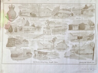
Work on paper - Sketch - The School of Military Survey, Bonegilla
Bonegilla operated as an army base from September 1940 and by 1943 was expanded to 848 buildings, including a general hospital. It provided training for small arms instructors, signallers, transport workers, bomb disposal and gas warfare personnel. In a response to the need to house the growing number of displaced persons coming to Australia, the Bonegilla Reception and Training Centre began operating in 1947. For some time it was a shared facility but the Army withdrew temporarily from Bonegilla in 1949, whilst still retaining ownership of the site. From 1949-65 Bonegilla Reception and Training Centre operated without a military presence. However, in the late 1960s and Australia’s commitments to the Vietnam War and pressed by the need to find accommodation to train men, especially National Servicemen, the Army negotiated with the Department of Immigration to take over several blocks at Bonegilla in 1965. Thirty-five huts were acquired by the Royal Australian Army Ordnance Corps as a Recruit Training Centre in which National Servicemen and recruits could attend 10-week ordnance courses. Shortly afterwards additional huts were acquired by the School of Military Survey, which established field-survey practical training areas and special astronomical observation sites as it began conducting courses in surveying. Instructors and trainees co-located at Bonegilla with migrant reception centre. In 1971 the Reception Centre closed and the site reverted to the Army. Progressively after 1971 the Army undertook a major site redevelopment with the construction of Latchford Barracks as the Army Apprentice School. Later Latchford Barracks was redeveloped into part of the Army Logistic Training Centre. Block 19 of the Mirant Reception Centre later became the Bonegilla Migrant Experience Heritage Park.This item depicts a heritage listed historical site located in the Wodonga district.A large poster size representation of the variety of buildings at Bonegilla, Victoria when it served as the location for the Royal Australian School of Military Survey. The insignia of the Royal Australian Survey Corps is featured in the top left hand corner.Top left corner: Insignia of the Royal Australian Survey Corps At bottom of sketches: "The School of Military Survey, Bonegilla Victoria / January 1966 - December 1982migrant reception centre bonegilla, army at bonegilla, australian military -
 Doncaster RSL Sub Branch
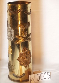
Shell Case, 18 Pound Shell Case, shell case marked 1940
Brass shell case with various insignia attachedInsignia; Royal Marines Epaulette;Royal Marines Gibralter; Kings Own Scotland Borderers;Royal Army Ordnance Corp;Australian Engineers; Australian Intelligence Corp;Tank Corp Badges;Australian Rising Sun Hat Badge AIF;Tunic Collar Badge AIF; Australian Epaulette AIF;Australian Artillery Hat Badge Perm Forces;Cross Cannons with No 70 Italian found in abandoned fort in North Africa1941;Eagle with spread wings Italian pound in abandoned fort North Africa -
 Bendigo Military Museum
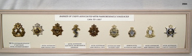
Badge - VARIOUS BADGES, FRAMED, c.1998
Cream wooden framed selection of 9 badges displayed on cream coloured background.Top centre: “BADGES OF CORPS ASSOCIATED WITH PASSCHANDAELE BARRACKS 1964 TO 1977” Underneath each badge: “1. Royal Australian Infantry 2nd Battalion Royal Victorian Regiment 2. & 3. Royal Australian Army Service Corps 4. Royal Australian Electrical & Mechanical Engineers” 5. Royal Australian Army Medical Corp 6. Australian Army Catering Corp 7. Women's Royal Australian Army Corps 8. Royal Australian Army Ordnance Corps 9. Royal Australian Corps of Transportpasschendaele barracks trust, badges, framed -
 Flagstaff Hill Maritime Museum and Village
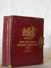
Book - Instruction Manual, British War Office, Manual of Siege and Garrison Artillery Exercises Vol 1, ca 24-06-1882
This little book has been designed to fit into a small space such as a pocket, backpack or trunk. The brass book lock helps keep the pages and covers together, preserving them from being bent, torn or damaged in handling.The book includes four of ten parts of the Manual, published for use in training the garrison troops, including the placement and firing of cannon. The four parts included in this Volume I are: - Part 1 - Gunnery Part 2 - Ammunition Part 3 - Siege Artillery Part 4 - Garrison Gun Drills The remaining six of then parts are: - Part 5 - Material and Appliances Part 6 - Elementary Instruction Part 7 - Machines Part 8 - Mounting and Dismounting Ordnance Part 9 - Sleighs Part 10 - Sheers and DerricksThe book is significant to both British and Australian history, being issued for the training of the garrison defense of both countries in the late 10th Century. It is also significant for its connection with other historical military items within the Collection at Flagstaff Hill Maritime Museum and Village.Manual of Siege and Garrison Artillery Exercises Vol 1 [Parts I, II, III, IV] Publisher Her Majestys Stationery Office Date 1879, Corrected June 24th 1882 Small, red, hard-cover book with embossed gold letters and British Coat of Arms on the front. The book has a brass closure or locking clip across the text block. There are diagrams and a foldout table within the text. flagstaff hill, flagstaff hill maritime museum and village, warrnambool, maritime museum, maritime village, great ocean road, shipwreck coast, training manual, book, british garrison, garrison artillery, siege exercises, british government training book, technical book, pocket book, manual of siege and garrison artillery exercises vol 1, garrison exercises, military training, defense training, british artillery, royal artillery, gunnery, gun drill, brass book lock, british war office, locking clip, reference book -
 Bendigo Historical Society Inc.
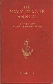
Book - THE NAVY LEAGUE ANNUAL
A red hard covered book with an illustration of an anchor on the front cover. Titled ''The Navy League Annual.'' '' (corrected to October 10th, 1909). Founded and edited by Alan H. Burgoyne. :The Fleet of England is her all in all.'-Tennyson. Third year of issue. Part 1 The Editor Part 11Lord Elcho; Graf Ernst Von Reventlow; Hector C. Bywater; Maurice Loir, Secretaire Central de la Ligue Maritime Francaise; Satori Kato; Maxime Laubeuf, late Engineer in-Chief of the French Navy; J. Alec Mitchell; ''Naval Constructor''; 'Blue Peter.' Part 111 List of ships, comparative, statistical, dock and ordnance tables : The Editor.'' October 21st (Trafalgar Day), 1909. London John Murray, Albemarle Street, W. 279pgs. (ii.)Alan H. Burgoyne, Editorbooks, military, navy, book, books, ships, shipping, navy, navies, war, warships, battleships, bendigo free library view street -
 Montmorency–Eltham RSL Sub Branch
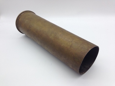
Weapon - 6-Pounder Shell Case, E.C.C, 1942
The Ordnance QF 6-pounder (57mm) 7 cwt was a British anti-tank gun used by both British and Commonwealth forces during World War II. Different versions of the gun were used on tanks, armoured cars and naval vessels. One version - the Molins Gun - was even used on an aircraft. Designed to replace the QF 2-pounder (40mm) it was first used by Australian troops during the El Alamein battles in 1942. The guns were also made in Australia by General Motors Holden who produced 615 of them, delivering the first gun in July 1942. The United States Army also adopted it and called it the 57mm Gun M1. Ammunition was primarily armour-piercing but in March 1944 a high-explosive round was introduced. The shell case shown here would have contained a 2.86kg (6lb 5oz) armour-piercing projectile. Brass Shell CaseOn Base of Cartridge: 6PR 7CWT LOT E.C.C. 236 On central firing disc: No. 15 II 11C 41 115 TH 1- -42 7 1942 F. T -
 Wodonga & District Historical Society Inc
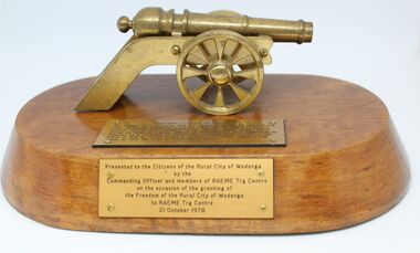
Memorabilia - Commemorative Award from RAEME unit to the Rural City of Wodonga, 1978
RAEME Corps was first established in 1942 when the Ordnance Corps and the Service Corps were combined. The royal ascent was granted in 1948. The Royal Australian Electrical and Mechanical Engineers (RAEME) is a technical corps tasked with the maintenance of the Army's modern hardware and equipment. RAEME personnel are represented in most Army units. The Royal Australian Electrical and Mechanical Engineers corps motto is ‘Arte et Marte’, which is Latin for ‘With Skill and Fighting’. This item, was presented to the Council of the Rural City of Wodonga in 1978. RAEME has a long association with Wodonga due to its service at the Bandiana base just outside of Wodonga. The inscription on the side of the base reads: "Presented to the Citizens of the Rural City of Wodonga by the Commanding Officer and members of RAEME Trg Centre on the occasion of the granting of the Freedom of the Rural City of Wodonga to RAEME Trg Centre 21 October 1978RAEME Corps has a long association with the city of Wodonga through its involvement in training and logistics at the army base at Bandiana.An award featuring a small model of the cannon "Zamzama" (Captor of Forts) mounted on a polished wooden base. The award includes a plaque outlining the significance of "Zamzama" on the top and another plaque explaining the significance on this award on the front of the base.Explanation of "Zamzama" beside cannon: "ZAMZAMA (CAPTOR OF FORTS)/ The original 14' 4 1/2" long, with 9 1/2" bore, was cast in brass in one/ piece by Muslim engineers in the year 1757 on the orders of the/ emperor AHMAD-SHAH-ABDALI. It was used in several battles and/ proved its value as a great weapon of destruction. It soon became to be/ regarded as a "Tallsman of Power" and continued as such until it was/ ruined in 1818 at Multan. Today it is housed in Lahore, where it was/ placed by H.R.H. the Duke of Edinburgh in 1870."raeme, rural city of wodonga, freedom of the city wodonga, australian military, bandiana -
 Wodonga & District Historical Society Inc
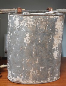
Equipment - Knapsack spray unit for agriculture and firefighting, A. Simpson & Son, c1939
This model of knapsack sprayer was used for both agricultural and firefighting purposes throughout Australia. The manufacturer, A. Simpson & Son who had a long history as a prominent metals manufacturer in Adelaide, South Australia. Alfred Simpson arrived in South Australia in 1849 and by the mid 1950s had established himself as a tinsmith. His son, also Alfred, joined the business in 1864. By the time of Alfred senior's death in 1891, A. Simpson and Son had the largest metal manufacturing plant in Australia. The business was incorporated in 1910, with Alfred as chairman, and his sons Allen and Frederick as directors. During World War I the company also manufactured munitions as well as ordnance. In the 1920s the company expanded into the production of tools for use in agriculture and in the 1940s they began the manufacture of whitegoods. In 1963 A. Simpson and Son merged with Pope Industries to form Simpson Pope Holdings.This item is representative of agricultural equipment used throughout Australia by a major Australian manufacturer. They were used extensively in the Wodonga district. A Backpack Sprayer unit made from galvanised iron used for agricultural and fire-fighting purposes. It has a nozzle spray attachment and originally had leather straps.On side: SIMPSON PAT. 11?472 23/7/39fire equipment, a. simpson & son, agricultural tools -
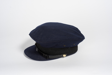 City of Greater Bendigo - Civic Collection
Uniform - Department of Supply Cap, 1971
Established in 1950, the Department of Supply headquarters transferred to Canberra in January 1968 and was dissolved in 1974. It was superseded by the Department of Manufacturing Industry and Department of the Special Minister of State. The Department was a Commonwealth Public Service department, staffed by officials who were responsible to the Minister for Supply. The department's main function was to support Australia's Navy, Army and Air Force in defence production, research and development, purchasing, transport and storage. The Department was also the Commonwealth Disposals Authority. Finally, the Department was responsible for the Australian Antarctic program. Bendigo was the site of an Ordnance Factory and manufactured and reconditioned naval guns and mountings, turbine gears for large ships, general heavy engineering work, large fabricated structure and missile handling equipment. The factory was managed in 1970 by R.I.M Moss. The department may have had an office in the former Bendigo Post Office now the Bendigo Visitor Information Centre.Blue, felt or wool peaked service cap with woven band and plastic strap. Small brass buttons. The cap has a synthetic lining around the crown and on the roof of the cap. Marked on the inside with the maker's details.bendigo post office, city of greater bendigo uniform -
 Wodonga & District Historical Society Inc
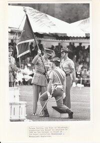
Mixed media - Presentation of Prince Philip's Banner to RAEME, 1986
RAEME Corps was first established in 1942 when the Ordnance Corps and the Service Corps were combined. The royal ascent was granted in 1948. The Royal Australian Electrical and Mechanical Engineers (RAEME) is a technical corps tasked with the maintenance of the Army's modern hardware and equipment. RAEME personnel are represented in most Army units. The Royal Australian Electrical and Mechanical Engineers corps motto is ‘Arte et Marte’, which is Latin for ‘With Skill and Fighting’. On the 5th March 1959, His Royal Highness, The Prince Philip, Duke of Edinburgh, accepted the appointment of Colonel-in-Chief of the Corps of the Royal Australian Electrical and Mechanical Engineers. On Tuesday 20 May 1986, His Royal Highness, The Prince Philip, Duke of Edinburgh, Colonel in Chief of the Royal Australian Electrical and Mechanical Engineers (RAEME) presented the Prince Philip Banner to the Corps at a Ceremonial Parade held at the RAEME Training Centre, Bandiana.These items are significant because they document an important event for the RAEME Unit at Bandiana.A collection of images and newspaper articles documenting an important event for the RAEME unit at Bandiana, Victoria. The Prince Philip features the Royal Cipher on the front and the RAEME Badge on the reverse.raeme, prince philip duke of edinburugh -
 Ringwood and District Historical Society
Newspaper, Scrapbook Clipping, Library Collection, Ringwood, Victoria
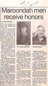
Newspaper Clipping from "The Mail", 28-1-97. P12 "Maroondah men receive honours"'. Two Maroondah men have been recognised in this year's Australia Day honours' list. They are Colonel David Jamison of North Ringwood, who has been appointed a member of the Order of Australia in the Military Division (AM), and Gordon Parker of Ringwood, who will receive the Order of Australia in the General Division. Mr Parker has been an active member of the British Commonwealth Occupation Forces Japan Association of Australia for more than 20 years. Col. Jamison has served 34 years in the Australian Army Ordnance Corps including six years as head of Capital Procurement in Melbourne. Both men are very proud to receive their awards. -
 Bendigo Military Museum
Album - PHOTOGRAPHS WW2, Post 1945
These photos were taken at Training Camps in Australia, Shepparton, Royal Park, Darby Camp, Balcombe, Alice Springs, NT, Larrakeyah, Darwin, Bombing of Darwin, Alice Springs, Adelaide River, New Guinea. There is several interesting photos of damage to Darwin Hotels by AIF units disgruntled at not being sent overseas. Allen Edward Malone VX46797 enlisted in the AIF on 13.7.1940, allotted to 8th Division, transferred to 2/4th Australian Field Workshops 8.2.1941, Moved to the NT arriving 8.5.1941, unit renamed 23rd Independant Group Ordnance W/Shops, moved to QLD 4.6.1943, posted to 2/137 Brigade W/Shops, promoted A/Cpl 26.6.1943, embark 12.7.1943 for New Guinea, detached for duty with 6th Aust Field Ambulance (Had previously done this with prior unit as a medical Orderly) Promoted Cpl 8.12.1943, Leave to Victoria 5.11.1944, embark at Townsville for New Britain 2.2.1945, disembark Brisbane 5.6.1945, discharged from the AIF 28.11.1945.1) Cover for Album, cardboard with a buckram finish, all black colours. .2) Album black covers, black pages with white glassien tissue sheets between each page, rear cover page has a envelope for a disc. Pasted on inside front cover is an A4 sheet typed with the service details re the owner and when taken, 20 pages have photos on with photo corners, photos have details written in white pen under them.On first page in white pen, "A.E. Malone Photo Album - photos taken during War service 1940 - 1945. Many of the photos were taken and developed by A.E. Malone"album ww2, malone collection -
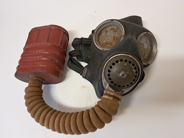 Glenelg Shire Council Cultural Collection
Functional object - World War II Gas Mask, 1939-1945
This gas mask was the standard issue gas mask for the Australian Army prior to and going into the Second World War. The mask featured two eye pieces made out of splinter-less glass which were removable to allow for decontamination of the mask without damaging the splinter-less glass eye pieces. The filter box was manufactured by Willow in Melbourne. The mask features a tissot system, which uses air provided by the intake assembly to defog the eyepieces. Air breathed out passes directly through the outlet valve which was designed work as voice membrane in order to enhance the speech of the user Unknown to most is that the GSR series of masks were manufactured in Australia rather than being imported from the United Kingdom. This was mainly due to the long travel distance between the UK and Australia, as well as the fact that the UK could not afford to give out masks during the war. The majority of the masks were manufactured at the Commonwealth Ordnance Facility Maribyrnong in Melbourne.This mask is representative of Australian manufacture during WWII. It is part of the story of Australian military history.Gas mas with dark coloured rubber mask. The back of the mask has elastic harness with 6 straps. They can be tightened or loosened to fit. The front of the mask has two large glass eye pieces with metal rims and a metal outlet valve. A concertina fabric and rubber tube leads from the outlet valve to a reddish brown box which is the filter. One side of the mask has the word 'Normal' stamped into it.Mask: NORMAL (on left side) / DPR 12/40 (right side) Back of harness: No. 4 III / 5-11-49 Filter canister: No 4A / 1940 / E VIwar, wwii, world war two, second world war, adult gas mask, military, portland, glenelg shire, army -
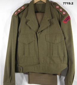 Bendigo Military Museum
Uniform - JACKET, TROUSERS, BATTLE DRESS, ARMY, Australian Defence Industries, 1. 1977 2. 1968
Uniform issued to "LOCKYER" 114493.Jacket - khaki colour wool serge fabric, Battle dress style, belted at waist with metal buckle. Dark green plastic buttons. Collar, shoulder epaulettes, two front pockets with concealed button down flap and sleeve cuffs. Shoulder epaulettes - rank three pips, red, cream and brown embroidery for Captain. Shoulder sleeve insignia, red fabric with dark blue embroidered lettering. "ROYAL AUSTRALIAN ARMY/ ORDNANCE CORPS". Green colour cotton twill fabric pocket and waist lining, manufacturers white cor=tton label inside pocket lining. 2. Trousers - khaki colour wool serge fabric, Battle Dress style, with fob pocket, two side pockets, one back pocket with concealed button down flap. Green colour polyester fabric lining with manufacturers white cotton label inside on back pocket, 6 button fly. Manufacturers information on labels - black ink print. 1. "A.G.C.F./ VIC 1977/^ /8405.66.025.6423/ SIZE OF CHEST/ SIZE 109/ 112PR/ YARRA FALLS 69/ BATCH, 21657/ DRY CLEAN ONLY/ CREASE UPPER/ HALF OF LAPELS ONLY/ NO./ NAME" Handwritten - blue ink pen - "LOCKYER/ 114493". 2. CONWAY BROS. PTY LTD/ ADELAIDE ^ 1968/ CLASS 8405-66-025-6199/ Y.F. PP2/ SIZE & WAIST 41PR/ MATCHING JACKET 43/44 P.R. / Dry Clean only/ Repress on original seams/ Creases set by Si-ro-set./ mending patch attached/ NAME/ ARMY NO." Handwritten black ink pen "LOCKYER/ 114493"uniform, army, battle dress, lockyer -
 Bendigo Historical Society Inc.
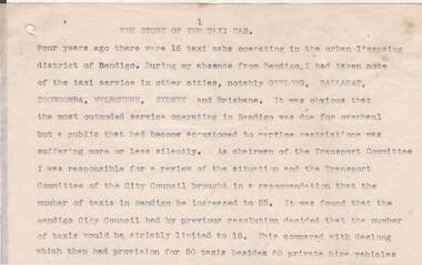
Document - NORMAN OLIVER COLLECTION: SPEECH NOTES FROM YEARS 1949-1971
The Norman Oliver collection. Norman Oliver was three times Mayor of Bendigo - 1950-51, 1964-65, 1970-71. a) Seventeen pages of typed notes for a speech. Topics include : The story of the taxi cab, Your library, Regional library development, Land reclamation, Traffic control, A point about parking, Social (visit to Fortuna by Major General Brown Director of Ordnance survey, British Army), The historical society. Undated, but next to other notes marked 1951. b) a donation letter headed 'The Mayor Speaks' states: Herein are the texts of addresses given by the Mayor Cr N.J Oliver over Radio Station 3BO, together with other talks given by him. They were given to Alex H Stone by Mr Oliver on his leaving Bendigo. They are now handed by him to Bendigo Branch - Royal Historical Society of Victoria, as they are worthy of preservation. 26-3-1982 signed Alex H Stone.bendigo, council, speech notes, norman joseph oliver , councillor norman oliver, sometime mayor of bendigo. radio station 3bo 'the mayor speaks'. bendigo centenary 1951. -
 Bendigo Military Museum
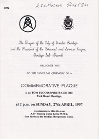
Pamphlet - COMMEMORATIVE PLAQUE 1997, C.1997
The Tom Flood Sports Centre was originally called The Bendigo Show Grounds. This plaque was unveiled by the City of Greater Bendigo & the Bendigo RSL Sub Branch to Commemorated the venue as a "Training Camp" during WW2. Order of Service was, Welcome, Mr Alan Holmes (President Bendigo RSL) Introduction of Recruits & Others associated with the Camp. A brief history of the Camp and Anecdotes was read by Mr Alan Holmes. Presentation and unveiling of the Plaque by Cr Barry Ackerman, Mayor City of Greater Bendigo. The wording: "Commemorating this site as an Australian Imperial Force Training Camp during WW2. "To the following Corps we pay Tribute" "10th AIF Training Depot" "Australian Army Medical Corps" "Australian Army Ordnance Corps" "Australian Army Service Corp". "Australian Electrical and Mechanical Engineers" Prayer of Thanksgiving & Commemoration by; Rev J. South. This was followed the "ODE, Last Post, One minutes Silence, Reveille and The National Anthem. As far as records available the Camp was first set up on 17.6.1940 with an Advance Party. The last Troops left there on 30.4.1943 for Ingleburn NSW, the Camp was vacated in May 1943. Pamphlet white paper, A4 folded making 4 pages, all print in black.On the front, "This Commemorative Plaque was unveiled at the Tom Flood Sports Centre Park Road Bendigo Sunday 27th April 1997"brsl, smirsl, plaque, tom flood, training camp -
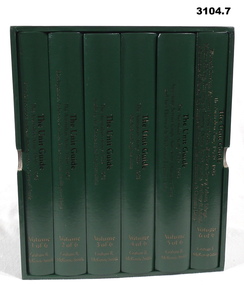 Bendigo Military Museum
Book - BOOKS, BOXED SET OF 6, Graham R McKenzie - Smith, The Unit Guide, 2018
Boxed set of 6 books. The Unit Guide, The Australian Army 1939 - 1945. .1) Box, open, cardboard, dark green buckram, white paper lining, gold print on sides. .2) - .7) Hard cover book, cardboard, dark green buckram with gold print on front cover & spine. Pages plain cut, black print, black & white illustrations. .2) 483 pages. .3) 605 pages. .4) 626 pages. .5) 654 pages. .6) 706 pages. .7) 568 pages..2) Volume 1 of 6. Unit & Location Indexes, Bibliography, Orders of Battle .3) Volume 2 of 6. Headquarters, Infantry, Cavalry, Armoured & Intelligence Units. .4) Volume 3 of 6. Artillery, Air Defence & Engineer Units. .5) Volume 4 of 6. Medical & Signals Units. .6) Volume 5 of 6. Aust Army Service Corp, Aust Army Ordnance Corp & Aust Electrical & Mechanical Engineer Units. .7) Volume 6 of 6. Women's Services, Volunteer Defence Corps, War Graves Survey, Labour Salvage, Military Policing, Recruiting & Training, Dental, Bath & Laundry, Veterinary & Animal, Movements & Transit, Pay, Records & Printing & Postal, Amenities & Canteens Units.books-military-history, units, 1939 - 45 -
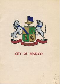 Bendigo Historical Society Inc.
Book - JOAN O'SHEA COLLECTION: 150TH ANNIVERSARY OF BENDIGO BOOKLET, 1850 - 1950's
Joan O'Shea Collection. Buff Coloured Booklet City of Bendigo. 150th anniversary of Bendigo 1850s to 1950s. Image on cover coat of arms for City of Bendigo underneath word progress, left hand side horse, right hand side bullock. History of Bendigo: From Sheep Run to Provincial City in 100 years. Map of Bendigo and Surrounds Railways, Water Courses & Storage, Power, Municipal Boundaries & Land Available for Industry. Municipal District Creation 1855, Borough Proclamation 1863, Proclaimed City 1871, Area: 7992 Acres Population as of last census City of Bendigo 28,722, City of Bendigo and adjacent Urban Areas 36,909. City of Bendigo Map, The Past Prior to 1850. Icons of Bendigo The Bendigo base Hospital,Law Courts & Post Office, Primary Schools, Housing, Industry including Butter Production, Poultry Farming, Livestock Sales & Tomato Growing, Slaughter House & ordnance factory. The Present Recreation Photos: Bendigo Bowling Club, Queen Elizabeth Oval, Municipal Lawn Tennis Courts The Future of Bendigo, Bendigo Photographs From The 1950s,Cambridge Press Bendigobendigo, history, progress of bendigo 1850s on. -
 Ballarat Heritage Services
Photograph - Colour, Earth Banks, Old Sarum, England, 2016, 01 November 2016
William the Conqueror inherited Old Sarum from the last Saxon king of England. It was an ideal site for a royal castle. It was here in 1070 that William paid off his army after a long and bitter campaign in northern England. It was here in 1086 that he called together all the major landholders in England so they could swear allegiance to him. It was a crucial moment. The Domesday Book was being written, a threatened Viking invasion had only just been averted and William's eldest son was in armed rebellion. Old Sarum was an important place where this Norman king of England held power. In 1794 the Ordnance Survey set out to check the accuracy of the first mapping of Southern England, which had begun ten years earlier. From a point just below Old Sarum Lieutenant William Mudge laid out a base-line 36,574 feet (11,253 metres) long. From each end of the line the positions of distant places were plotted using a huge theodolite made in 1791 by Jesse Ramsden. The accuracy of the process, which was repeated all over England, depended on Jesse Ramsden's craftsmanship and on William Mudge's surveying skill in setting out this first base-line from Old Sarum. The nearer end of Mudge's line is marked by an inscribed stone beside the modern A345 at Old Sarum. ordnance survey, william mudge, jesse ramsden, william the conqueror, old sarum, saxon, 1086, england -
 Ballarat Heritage Services
Photograph - Colour, Earth Banks, Old Sarum, England, 01 November 2016
William the Conqueror inherited Old Sarum from the last Saxon king of England. It was an ideal site for a royal castle. It was here in 1070 that William paid off his army after a long and bitter campaign in northern England. It was here in 1086 that he called together all the major landholders in England so they could swear allegiance to him. It was a crucial moment. The Domesday Book was being written, a threatened Viking invasion had only just been averted and William's eldest son was in armed rebellion. Old Sarum was an important place where this Norman king of England held power. In 1794 the Ordnance Survey set out to check the accuracy of the first mapping of Southern England, which had begun ten years earlier. From a point just below Old Sarum Lieutenant William Mudge laid out a base-line 36,574 feet (11,253 metres) long. From each end of the line the positions of distant places were plotted using a huge theodolite made in 1791 by Jesse Ramsden. The accuracy of the process, which was repeated all over England, depended on Jesse Ramsden's craftsmanship and on William Mudge's surveying skill in setting out this first base-line from Old Sarum. The nearer end of Mudge's line is marked by an inscribed stone beside the modern A345 at Old Sarum. ordnance survey, william mudge, jesse ramsden, william the conqueror, old sarum, saxon, 1086, england -
 Ballarat Heritage Services
Photograph - Colour, Stonework, Old Sarum, England, English Heritage Site, 01 November 2016
William the Conqueror inherited Old Sarum from the last Saxon king of England. It was an ideal site for a royal castle. It was here in 1070 that William paid off his army after a long and bitter campaign in northern England. It was here in 1086 that he called together all the major landholders in England so they could swear allegiance to him. It was a crucial moment. The Domesday Book was being written, a threatened Viking invasion had only just been averted and William's eldest son was in armed rebellion. Old Sarum was an important place where this Norman king of England held power. In 1794 the Ordnance Survey set out to check the accuracy of the first mapping of Southern England, which had begun ten years earlier. From a point just below Old Sarum Lieutenant William Mudge laid out a base-line 36,574 feet (11,253 metres) long. From each end of the line the positions of distant places were plotted using a huge theodolite made in 1791 by Jesse Ramsden. The accuracy of the process, which was repeated all over England, depended on Jesse Ramsden's craftsmanship and on William Mudge's surveying skill in setting out this first base-line from Old Sarum. The nearer end of Mudge's line is marked by an inscribed stone beside the modern A345 at Old Sarum. ordnance survey, william mudge, jesse ramsden, william the conqueror, old sarum, saxon, 1086, england -
 Ballarat Heritage Services
Photograph - Colour, Stonework, Old Sarum, England, English Heritage Site, 2016, 01 November 2016
William the Conqueror inherited Old Sarum from the last Saxon king of England. It was an ideal site for a royal castle. It was here in 1070 that William paid off his army after a long and bitter campaign in northern England. It was here in 1086 that he called together all the major landholders in England so they could swear allegiance to him. It was a crucial moment. The Domesday Book was being written, a threatened Viking invasion had only just been averted and William's eldest son was in armed rebellion. Old Sarum was an important place where this Norman king of England held power. In 1794 the Ordnance Survey set out to check the accuracy of the first mapping of Southern England, which had begun ten years earlier. From a point just below Old Sarum Lieutenant William Mudge laid out a base-line 36,574 feet (11,253 metres) long. From each end of the line the positions of distant places were plotted using a huge theodolite made in 1791 by Jesse Ramsden. The accuracy of the process, which was repeated all over England, depended on Jesse Ramsden's craftsmanship and on William Mudge's surveying skill in setting out this first base-line from Old Sarum. The nearer end of Mudge's line is marked by an inscribed stone beside the modern A345 at Old Sarum. ordnance survey, william mudge, jesse ramsden, william the conqueror, old sarum, saxon, 1086, england -
 Ballarat Heritage Services
Photograph - Colour, Stonework and well, Old Sarum, England, English Heritage Site, 2016, 01 November 2016
William the Conqueror inherited Old Sarum from the last Saxon king of England. It was an ideal site for a royal castle. It was here in 1070 that William paid off his army after a long and bitter campaign in northern England. It was here in 1086 that he called together all the major landholders in England so they could swear allegiance to him. It was a crucial moment. The Domesday Book was being written, a threatened Viking invasion had only just been averted and William's eldest son was in armed rebellion. Old Sarum was an important place where this Norman king of England held power. In 1794 the Ordnance Survey set out to check the accuracy of the first mapping of Southern England, which had begun ten years earlier. From a point just below Old Sarum Lieutenant William Mudge laid out a base-line 36,574 feet (11,253 metres) long. From each end of the line the positions of distant places were plotted using a huge theodolite made in 1791 by Jesse Ramsden. The accuracy of the process, which was repeated all over England, depended on Jesse Ramsden's craftsmanship and on William Mudge's surveying skill in setting out this first base-line from Old Sarum. The nearer end of Mudge's line is marked by an inscribed stone beside the modern A345 at Old Sarum. ordnance survey, william mudge, jesse ramsden, william the conqueror, old sarum, saxon, 1086, england