Showing 527 items
matching panoramas
-
 Kew Historical Society Inc
Photograph, J F C Farquhar, Studley Park Road, 1891
At the beginning of the 1890s, the Kew businessman and Town Councillor, Henry Kellett, commissioned J.F.C. Farquhar to photograph scenes of Kew. These scenes included panoramas as well as pastoral scenes. The resulting set of twelve photographs was assembled in an album, Kew Where We Live, from which customers could select images for purchase.The preamble to the album describes that the photographs used the ‘argentic bromide’ process, now more commonly known as the gelatine silver process. This form of dry plate photography allowed for the negatives to be kept for weeks before processing, hence its value in landscape photography. The resulting images were considered to be finely grained and everlasting. Evidence of the success of Henry Kellett’s venture can be seen today, in that some of the photographs are held in national collections.It is believed that the Kew Historical Society’s copy of the Kellett album is unique and that the photographs in the book were the first copies taken from the original plates. It is the first and most important series of images produced about Kew. The individual images have proved essential in identifying buildings and places of heritage value in the district.In this view of Studley Park Road, looking northeast to the Junction, the photographer invites the viewer to participate in a point-of-view that emphasises the elevated, tranquil vantage point of the hill in contrast to the bustling commercial area in the distance. The view emphasises the exclusiveness of Studley Park, with its high fences behind which a number of significant Kew mansions were concealed. Contemporary advertisements for the sale of mansions in Studley Park Road often included fulsome descriptions of their elaborate formal gardens, as well as paddocks for grazing, stabling and dairies. None can be seen here. The use of high, protective wooden pickets to surround the newly planted avenue of elms on the south side of the road appears to be typical of the period. Similar examples can be seen in early photographs of Wellington and Princess Streets.The horse and carriage, selected as a central focus of the view, reinforces the residential, exclusive nature of this part of Kew in the early 1890s. Studley Park Roadkew illustrated, kew where we live, photographic books, henry kellett -
 Kew Historical Society Inc
Photograph, J F C Farquhar, A View in Studley Park Road, 1891
At the beginning of the 1890s, the Kew businessman and Town Councillor, Henry Kellett, commissioned J.F.C. Farquhar to photograph scenes of Kew. These scenes included panoramas as well as pastoral scenes. The resulting set of twelve photographs was assembled in an album, Kew Where We Live, from which customers could select images for purchase.The preamble to the album describes that the photographs used the ‘argentic bromide’ process, now more commonly known as the gelatine silver process. This form of dry plate photography allowed for the negatives to be kept for weeks before processing, hence its value in landscape photography. The resulting images were considered to be finely grained and everlasting. Evidence of the success of Henry Kellett’s venture can be seen today, in that some of the photographs are held in national collections.It is believed that the Kew Historical Society’s copy of the Kellett album is unique and that the photographs in the book were the first copies taken from the original plates. It is the first and most important series of images produced about Kew. The individual images have proved essential in identifying buildings and places of heritage value in the district.This is the earliest known photograph of the exterior of Byram (later Tara Hall). It shows the original red brick fence, its asymmetrical gate and gateposts, with a large terra cotta gargoyle surmounting the higher of the two. The architect, Edward Kilburn designed Byram in the Arts & Crafts style for the industrialist George Ramsden. Construction began in 1888 and was reputed to have lasted three years. The mansion had frontages to Studley Park Road and Stevenson Street, including gardens laid out with great taste, including pleasure grounds, tennis lawn, fruit and flower garden, and paddock. The size of many of the trees in the garden indicate that many survived from the garden of Clifton Villa, the previous single-storeyed house built on the site by the Stevenson brothers. Byram had views to Melbourne and Port Phillip Bay. The house was demolished in 1960, despite opposition from the National Trust (Victoria), and its gardens subdivided into residential allotments.A View in Studley Park Roadkew illustrated, kew where we live, photographic books, henry kellett, byram, tara hall, goathlands -
 Kew Historical Society Inc
Photograph, J F C Farquhar, Railway Bridge Over the Yarra, 1891
At the beginning of the 1890s, the Kew businessman and Town Councillor, Henry Kellett, commissioned J.F.C. Farquhar to photograph scenes of Kew. These scenes included panoramas as well as pastoral scenes. The resulting set of twelve photographs was assembled in an album, Kew Where We Live, from which customers could select images for purchase.The preamble to the album describes that the photographs used the ‘argentic bromide’ process, now more commonly known as the gelatine silver process. This form of dry plate photography allowed for the negatives to be kept for weeks before processing, hence its value in landscape photography. The resulting images were considered to be finely grained and everlasting. Evidence of the success of Henry Kellett’s venture can be seen today, in that some of the photographs are held in national collections.It is believed that the Kew Historical Society’s copy of the Kellett album is unique and that the photographs in the book were the first copies taken from the original plates. It is the first and most important series of images produced about Kew. The individual images have proved essential in identifying buildings and places of heritage value in the district.Completed in November 1890, the railway viaduct (now the Chandler Highway Bridge) linked Kew and Fairfield. The viaduct is significant as the most substantial extant engineering remnant of the Outer Circle Railway Line. Opened in March 1891, the viaduct crossed the Yarra River in a single span, atop three supporting brick pillars. Following the closure of the railway line in 1927, and the construction of the Chandler Highway in 1930, the bridge was used for vehicular traffic. In 1891 when this panoramic photograph was taken, the grounds of what was then the Kew Lunatic Asylum extended down to the River and eastward beyond the viaduct. The landscape surrounding the Asylum was planted with traditional exotic trees such as Oaks, Pines and Cedars, and landmark trees from northern Australia such as the Hoop Pine. Remnant indigenous trees such as the River Red Gum, Yellow Box and Lightwood were scattered around the site, including beside the Yarra River.Railway Bridge Over the Yarrakew illustrated, kew where we live, photographic books, henry kellett, railway viaduct - - kew (vic) -
 Kew Historical Society Inc
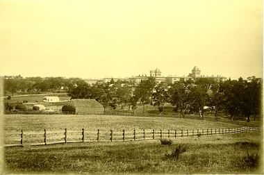
Photograph, J F C Farquhar, Kew Asylum & Grounds, 1891
At the beginning of the 1890s, the Kew businessman and Town Councillor, Henry Kellett, commissioned J.F.C. Farquhar to photograph scenes of Kew. These scenes included panoramas as well as pastoral scenes. The resulting set of twelve photographs was assembled in an album, Kew Where We Live, from which customers could select images for purchase.The preamble to the album describes that the photographs used the ‘argentic bromide’ process, now more commonly known as the gelatine silver process. This form of dry plate photography allowed for the negatives to be kept for weeks before processing, hence its value in landscape photography. The resulting images were considered to be finely grained and everlasting. Evidence of the success of Henry Kellett’s venture can be seen today, in that some of the photographs are held in national collections.It is believed that the Kew Historical Society’s copy of the Kellett album is unique and that the photographs in the book were the first copies taken from the original plates. It is the first and most important series of images produced about Kew. The individual images have proved essential in identifying buildings and places of heritage value in the district.When the Kew Lunatic Asylum was opened in 1871, its extensive 340 acres of grounds were intended for farming, agriculture and recreation for the inmates. The point-of-view chosen by Farquhar for this panoramic photograph focuses on the ordered open fields, haystacks and remnant trees that extended from the foreground to the rear of the Asylum. The inmates are the absent players in this pastoral idyll. In 1891, The Argus reported on the Annual Asylum Picnic: “Wednesday saw the Kew picnic, the yearly festival of the mad folks and their keepers. Once a year the public subscribes for cakes and ale for all these mad folks, and their keepers, from superintendent to lowest wardsman, turn out, and use their best endeavours to make one day in the year sanely merry.” Regardless of such merriment, the Asylum’s development and ongoing status were frequently a source of disquiet to the residents of Kew, who regularly petitioned the State Government for its removal. Despite these views, the Asylum was to remain a functioning institution from 1871 to 1988. Kew Asylum & Groundskew illustrated, kew where we live, photographic books, henry kellett, kew lunatic asylum -
 Kew Historical Society Inc
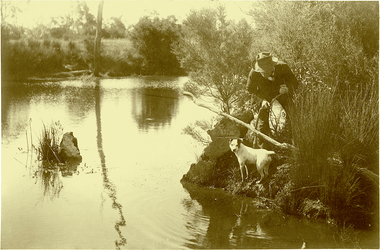
Photograph, J F C Farquhar, Ratting on the Yarra, 1891
At the beginning of the 1890s, the Kew businessman and Town Councillor, Henry Kellett, commissioned J.F.C. Farquhar to photograph scenes of Kew. These scenes included panoramas as well as pastoral scenes. The resulting set of twelve photographs was assembled in an album, Kew Where We Live, from which customers could select images for purchase.The preamble to the album describes that the photographs used the ‘argentic bromide’ process, now more commonly known as the gelatine silver process. This form of dry plate photography allowed for the negatives to be kept for weeks before processing, hence its value in landscape photography. The resulting images were considered to be finely grained and everlasting. Evidence of the success of Henry Kellett’s venture can be seen today, in that some of the photographs are held in national collections.It is believed that the Kew Historical Society’s copy of the Kellett album is unique and that the photographs in the book were the first copies taken from the original plates. It is the first and most important series of images produced about Kew. The individual images have proved essential in identifying buildings and places of heritage value in the district.In Farquhar’s close-up portrait of the rat catcher and his dog, the photographer excludes any extraneous data that otherwise might have provided a spatial or motivational context. The contemporary or the present day viewer is required to construct a narrative to explore or understand what is occurring. The title of the picture might incline a viewer to believe that what they see is an exercise in vermin control, and that the rat concerned might be an introduced black or brown rodent. A more likely scenario is that the rat catcher is focussed on catching ‘rakali’, a native water-rat once widely trapped for its fur. The trapping of rakali for use in the manufacture of fashionable clothing accelerated as introduced furs such as musquash became more expensive. It was not until 1938 that rakali were granted protected status.Ratting on the Yarrakew illustrated, kew where we live, photographic books, henry kellett, yarra river -
 Kew Historical Society Inc
Photograph, J F C Farquhar, Dight's Falls, 1891
At the beginning of the 1890s, the Kew businessman and Town Councillor, Henry Kellett, commissioned J.F.C. Farquhar to photograph scenes of Kew. These scenes included panoramas as well as pastoral scenes. The resulting set of twelve photographs was assembled in an album, Kew Where We Live, from which customers could select images for purchase.The preamble to the album describes that the photographs used the ‘argentic bromide’ process, now more commonly known as the gelatine silver process. This form of dry plate photography allowed for the negatives to be kept for weeks before processing, hence its value in landscape photography. The resulting images were considered to be finely grained and everlasting. Evidence of the success of Henry Kellett’s venture can be seen today, in that some of the photographs are held in national collections.It is believed that the Kew Historical Society’s copy of the Kellett album is unique and that the photographs in the book were the first copies taken from the original plates. It is the first and most important series of images produced about Kew. The individual images have proved essential in identifying buildings and places of heritage value in the district.Dight’s Falls in Studley Park is an artificial weir built on a natural rock bar across the Yarra. The weir was built in the 1840s to provide water to the ‘Ceres’ flour mill, one of the earliest industrial sites in Melbourne. The falls were later to be named after the owner of this mill. In 1888, William Guilfoyle, Director of the Melbourne Botanical Gardens had called for fresh water to be piped from above the weir to the Botanical Gardens, using a pumping station on the Kew side of the Falls, a holding reservoir in Walmer Street and a series of pipes from there to the Gardens. This system was opened in May 1891. Farquhar’s photograph of the man-made weir obscures the industrial activity on both sides of the Falls and focusses solely on the river and the surrounding natural vegetation. The photograph probably predates the disastrous flooding of the Yarra River in July 1891, the greatest to have occurred in the Colony since the foundation of Melbourne.Dight's Fallskew illustrated, kew where we live, photographic books, henry kellett, yarra river -
 Kew Historical Society Inc
Photograph, J F C Farquhar, The Yarra in Hyde Park, 1891
At the beginning of the 1890s, the Kew businessman and Town Councillor, Henry Kellett, commissioned J.F.C. Farquhar to photograph scenes of Kew. These scenes included panoramas as well as pastoral scenes. The resulting set of twelve photographs was assembled in an album, Kew Where We Live, from which customers could select images for purchase.The preamble to the album describes that the photographs used the ‘argentic bromide’ process, now more commonly known as the gelatine silver process. This form of dry plate photography allowed for the negatives to be kept for weeks before processing, hence its value in landscape photography. The resulting images were considered to be finely grained and everlasting. Evidence of the success of Henry Kellett’s venture can be seen today, in that some of the photographs are held in national collections.It is believed that the Kew Historical Society’s copy of the Kellett album is unique and that the photographs in the book were the first copies taken from the original plates. It is the first and most important series of images produced about Kew. The individual images have proved essential in identifying buildings and places of heritage value in the district.Hyde Park is now a small recreation reserve bordered by Willsmere and Kilby Roads and White Avenue. In 1982, Hyde Park was cut off from the Yarra River by the construction of the Eastern Freeway. The building of the latter was to transform the natural landscape, including the Yarra, as well as Hyde Park. The construction of the Freeway makes it difficult to view the scene with the photographer’s eye. Today’s Hyde Park is located on land purchased in 1847 by John Cowell, and in 1851 Catherine Cowell, yet the scene selected by the photographer may well have been located on farmland owned by the Wills family. Farquhar’s point-of-view emphasises both the pastoral and recreational elements of the scene: the grazing cows, three boys, and in the distance two figures, seated on the bank with a parasol. By 1891, an environmental consequence of human activity, including farming, was deforestation, leading to the erosion of the south bank of the Yarra. In contrast, the land on the Alphington side of the river in 1891 included remnant bushland.The Yarra in Hyde Parkkew illustrated, kew where we live, photographic books, henry kellett, yarra river -
 Kew Historical Society Inc
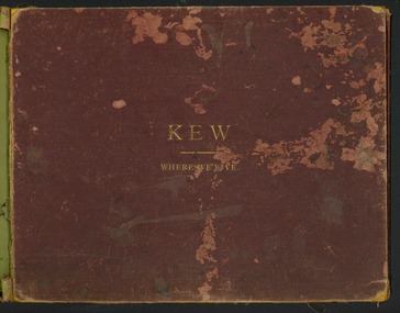
Book, Henry de Castres Kellett BT, Kew Where We Live : Kew Illustrated, 1891
At the beginning of the 1890s, the Kew businessman and Town Councillor, Henry Kellett, commissioned J.F.C. Farquhar to photograph scenes of Kew. These scenes included panoramas as well as pastoral scenes. The resulting set of twelve photographs was assembled in an album, Kew Where We Live, from which customers could select images for purchase.The preamble to the album describes that the photographs used the ‘argentic bromide’ process, now more commonly known as the gelatine silver process. This form of dry plate photography allowed for the negatives to be kept for weeks before processing, hence its value in landscape photography. The resulting images were considered to be finely grained and everlasting. Evidence of the success of Henry Kellett’s venture can be seen today, in that some of the photographs are held in national collections.It is believed that the Kew Historical Society’s copy of the Kellett album is unique and that the photographs in the book were the first copies taken from the original plates. It is the first and most important series of images produced about Kew. The individual images have proved essential in identifying buildings and places of heritage value in the district.A unique Illustrated book, comprising a series of twelve plates of panoramic and landscape photographs of Kew, commissioned from the Melbourne (and Kew) photographer JFC Farquhar, by the Kew stationer Henry Kellett. The book was published in 1891, so it is presumed that the photographs provided by Farquhar were taken in 1891 or in the previous year. Photographs from the cloth bound book were offered by Kellett for sale separately; hence a number are in public collections. The book is in very poor condition, the leaves having separated from the spine. The cover is suffering from red rot while the mounts of each book plate are dirty and frequently suffering from foxing. The actual silver albumen plates variably suffer from foxing and iridescence caused by the deterioration resulting from the photographic process. Each part of the book can be viewed in this record in sequential format.KEW WHERE WE LIVE / KEW ILLUSTRATED / THE ACCOMPANYING ILLUSTRATIONS ARE PHOTOGRAPHIC VIEWS OF KEW AND ITS SURROUNDINGS, EXECUTED BY THE "ARGENTIC BROMIDE PROCESS", WHICH ENSURES ABSOLUTE PERMANENCY OF THE PHOTOGRAPH. IN A FEW YEARS HENCE WHEN MOST OF THE OLD LANDMARKS WILL HAVE DISAPPEARED THESE VIEWS WILL BE A VALUABLE MEMENTO OF KEW AS IT WAS IN 1891. ANY OF THESE ILLUSTRATIONS GAN BE OBTAINED FROM MR. H. KELLETT, HIGH STREET, KEW, IN SINGLE COPIES, IN THE SAME SIZE AS THOSE HEREIN AT 2s PER COPY. THEY MAY ALSO BE OBTAINED IN THE FOLLOWING SIZES FOR FRAMING:- / ACTUAL SIZE OF PHOTOGRAPH 15 INCHES X 12 INCHES @ 8. 6d EACH / 22 INCHES X 16 INCHES @ 15s EACH / PRIVATE RESIDENCES AND ESTATES / SPECIAL ARRANGEMENTS CAN BE MADE FOR TAKING VIEWS OF PRIVATE RESIDENCES - INTERIOR AND EXTERIOR - AND FOR GROUPS, &C., IN ANY SIZE UP TO 40 INCHES BY 30 INCHES BY THE "ARGENTIC BROMIDE" PROCESS UPON APPLICATION TO / MR H. KELLETT / HIGH STREET, KEW.kew illustrated, kew where we live, photographic books, henry kellett, jfc farquhar - photographer -
 Warrnambool and District Historical Society Inc.
Album, Warrnambool and District 1886 Western Hotel, 1886
This album contains a number of local coastal and seascapes including Thunder Point, views of local streets such as Liebig and Fairy streets, panorama views of the town from Manse Hill and Booval Hill and the Botanic Gardens. Buildings included are Cramond and Dickson, St Joseph’s Church, the saleyards. The book itself would have been used by patrons of the Western Hotel when J Fox was licensee, from 1880 until 1887. The hotel had been operating since 1870 when William O’Brien applied for a publican’s license for the house on the corner of Timor and Kepler Streets with five sitting rooms and eight bedrooms. The stone building was designed by Andrew Kerr and built by Williams & Co. The Western Hotel was also the booking office for Cobb and Co Coaches which operated until the railway came to town in 1890. This album has historical significance on different levels. Firstly the photographs provide a view of Warrnambool in the late 19th century. The photos are aesthetically and artistically significant. Many of the buildings in the streetscapes are still recognizable. Secondly the Western Hotel has occupied a prominent site within the CBD for nearly 150 years. It has links to Cobb & Co, an important part of early Australian transport. Large hard covered album. Dark green cover with title in red rectangle on front cover. Text in gold lettering. A variety of photographs mounted on card.Chuck Photo Ballarat on front cover. Small cutting pasted inside front cover, reads as follows,” Will and Estates. Joseph Fox, late of Grosvenor Street, Balaclava who died on 29th July by his will of 11th August 1915 left 3737pounds real estate and 2342 pounds personality to relatives. warrnambool, warrnambool history, warrnambool photographs of the past, western hotel photographs -
 Eltham District Historical Society Inc
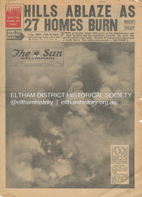
Newspaper - Newspaper articles, Sun News-Pictorial, Hills Ablaze As 27 Homes Burn, The Sun News-Pictorial, Monday, January 15, p1, 1962
Various news articles pertaining to the January 1962 Victorian bushfires in the Dandenong and Healesville districts. • Hills Ablaze As 27 Homes Burn; Night Fight, p1 (Illust.) • Yarra Glen, Healesville Saved; Fire into main street, p2 (Illust.) • Flare-up at Montrose, p2 • 20 scouts flee as fire sweeps camp, p2 • Gaol for fires today …, p2 • Timber lost, p2 • Heathmont home lost, but others saved, p2 • The desperate fight, p3 (Illust.) • Rubbish fire got away; Basin blaze, p3 • Panorama of destruction, p3 • Fire Captain Killed; 7 road deaths at week-end, p5 (Illust.) • Heartbreak, ruin as … Fire Sweeps the Hills, pp18-19 .(Illust.) • Tea; they made it for the fire fighters, pp18-19 (Illust.) tom fielding collection, victorian bushfires - 1962, victorian bushfires – 1962, dandenongs, the basin, yarra glen, healesville, montrose, chum creek, scouts, australian logging co., a.w. larkins, heathmont, vermont, r. pearson, mike ryan, vic parker, c.g. wilson, hillside farm, clive brewer, ron anderson, mrs anderson, mt dandenong, healesville rural fire brigade, malcolm barber, yarra flats, r. bicknell, ferny creek, blue hills gues house, heatherset road, sassafras, olinda, presbyterian manse, john gorie, janice gorie, lynette gorie, jacky wilson, patricia cortie -
 Eltham District Historical Society Inc
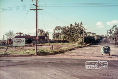
Slide, Site for the new Apex-Diamond Valley Ambulance Station, corner of Main Road and Grand Boulevard, Montmorency, July 1969, 1969
View looking west along Grand Boulevard from the intersection with Main Road and Panorama Avenue, Montmorency showing the site for the new Apex-Diamond Valley Ambulance Station and before construction of Apex Way, July 1969. The Eltham Apex Club conducted a Community Service Project (1965-1968) to raise funds for a new Ambulance Station to service the community. A site bounded by the intersection of Main Road, Grand Boulevard and Looker Road at Montmorency was purchased in 1969. In 1970, Eltham Shire Council undertook roadworks to construct Apex Way in preparation for the new station as well as duplicate Main Road, Lower Plenty, east of Grand Boulevard including the new Lower Plenty Bridge, which had been opened in November 1966, bordering with the City of Heidelberg.35 mm colour positive transparency Mount - Agfacolor Service (Blue)1969-07, ambulance station, apex way, grand boulevard, lower plenty, main road, montmorency, eltham ambulance station, apex-diamond valley ambulance station, eltham apex club -
 Victorian Interpretive Projects Inc.
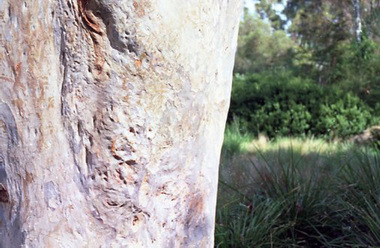
Photograph - Black and White, Ballarat, c1854
The town you see had over 50,000 people. Bridge Street on the left is well established. The crude pans and cradles of the early “diggers’ were already giving way to steam power and the deep shafts of the “miners”. Money and machinery were needed to get to the deeper leads, and the smoke stacks of the great company mines can be seen across the photo.Four black and white photographs placed together to make a panorama of Ballarat looking towards Mt Warrenheip. On the left the chimney and gasometer indicate the corner of Dana Street and Albert Street. This is now the Ballarat Law Courts. The photograph is behind glass in a black frame. These four photographs were taken from the slope of the Ballarat School of Mines where the Uniting Church now stands. When joined they give a panoramic view of one of the world’s richest alluvial goldfields. The Waterloo Mine was one of the first deep shafts and was sunk at the foot of the Dana Street hill. Its tailings are seen in the second photo from left. The following was typed and placed with the framed image. Ballarat Circa 1858 This is the most significant of the photographs of early Ballarat. The photographer stood on the slope near S.M.B. where the Wesley Church now stands and took four pictures. When joined them have this panoramic view of one of the world's richest alluvial goldfields. Seven years earlier this landscape was empty. The town you see had over 50,000 people. Bridge Street on the left is well established the Ballarat gas Company stands on the same place as today. The crude pans and cradles of the early "diggers" were already giving way to steam power and the deep shafts of the :"miners". Money and machinery were needed to get to the deeper leads, and the smoke stacks of the great company mines can be seen across the photo. The Waterloo mines was one of the first deep shafts and was sunk at the foot of the Dana Street hill. Its tailings are seen in the second photo from the left. ballarat, ballarat townscape, panorama, waterloo mine -
Stawell Historical Society Inc
Postcard, Stawell Photographic Booklet
Letter containing the following To whom it may Concern, I located this photographic memento of Stawell & the Surrounding district amongst my late parents belongings and thought it may be of interest tp your group as a curio. I would be please if you would accept and retain it.Yellow card Cover containing 9 B/W Photo Scenes of Stawell and Surrounding landmarksFront Cover Stawell Photographic Booklet Rear Cover: From ..... Published by the Valentine Publishing Co. Pty. Ltd. Melbourne an d Sydney 1: Panorama of Stawell 2: The Pinnacle The Grampians 3: The Oval, Central Park 4: Grand Canyon, The Grampians 5: The Willows, Victoria Park 6: Central Park 7: Main Street Looking west 8; The Sister Rocks 9: Rounda, Victoria Park STAWELL. Victoriatourism postcards -
 Bendigo Historical Society Inc.
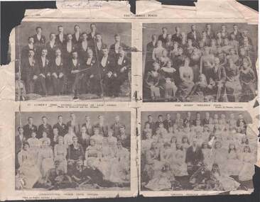
Newspaper - WEEKLY TIMES - CHURCH PHOTOS
Piece of Weekly times newspaper, (October 1900) in poor condition. Exact Date unknown. Four images,Page 9 - St. Andrew's Choir, Bendigo, winners of male chorus,- photo by Richards & Co Ballarat / Neil Street Wesleyan Choir -photo by Fraser , Ballarat / , Congregational Church Choir, Bendigo -photo by Fraser , Ballarat/ , Vernon's Junvenile Choir./ Pages 10 and 11 deal with photos taken at the horse races Mr Godfrey Watson , starter - Johnstone ? O'Shannessy & Co photo / Panorama of Grandstand and lawn - photo of a crowd watching the races / page 12 -photo 'Ballarat Liedertafel Winners of Intercolonial 1899-1900 a Images appear to date from late 1800's - early 1900's ?bendigo, churches, st. andrew's, congregational church, bendigo, choirs, st. andrew's, congregational church, neil street wesleyan choir, vernon's juvenile choir.'ballarat liedertafel winners of intercolonial 1899-1900 -
 Federation University Historical Collection
Photograph - Photograph - Black and White, Ballarat, c1858, c1858
Four photographs framed together to produce a panorama. The four photographs were taken from the slope of the Ballarat School of Mines where the Wesley Church now stands. When joined they gave a panoramic view of one of the world’s richest alluvial goldfields. The town you see had over 50,000 people. Bridge Street on the left is well established. The crude pans and cradles of the early “diggers’ were already giving way to steam power and the deep shafts of the “miners”. Money and machinery were needed to get to the deeper leads, and the smoke stacks of the great company mines can be seen across the photo. The waterloo mines was one of the first deep shafts and was sunk at the foot of the Dana Street hill. Its tailings are seen in the second photo from left. ballarat, ballarat gas works, mount warrenheip, shingle roof, mullock heap, mining -
 Marysville & District Historical Society
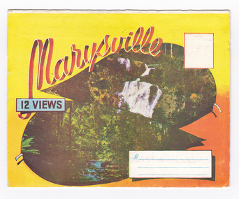
Postcard (item) - Colour photographs, Murray Views, Marysville 12 Views, 1950's
A fold out postcard of 12 colour photographs of scenes and landscapes in and around Marysville in Victoria.A fold out postcard 12 colour photographs of scenes and landscapes in and around Marysville in Victoria. These photographs were produced by Murray Views in Gympie, Queensland as a souvenir of Marysville.Marysville/ 12 VIEWS PRODUCED BY MURRAY VIEWS./ GYMPIE./ Q COPYRIGHT SAMUEL LEE & CO., PRINTERS. STEAVENSON'S FALLS, MARYSVILLE, VIC. TOURISTS AT MARYSVILLE, VIC. "FRUIT SALAD FARM", MARYSVILLE MAIN STREET, MARYSVILLE, VIC. ROAD SCENE, MARYSVILLE, VIC. THE CROSSWAYS, MARYSVILLE, VIC ROAD TO CUMBERLAND VALLEY, MARYSVILLE PANORAMA FROM BLACK SPUR, MARYSVILLE ROAD, MARYSVILLE, VIC. NICHOLL'S LOOKOUT, MARYSVILLE, VIC. TREE FERNS, MARYSVILLE, VIC. THE BRIDGE, MARYSVILLE, VIC.steavenson falls (image 1), tourists in marysville (image 2), taggerty river (image 3), fruit salad farm (image 4), main street marysville (image 5), road scene marysville (image 6), the crossways (image 7), cumberland valley (image 8), black spur (image 9), nicholl's lookout (image 10), tree ferns (image 11), bridge (image 12), marysville, victoria, postcard, souvenir, murray views -
 Marysville & District Historical Society
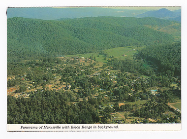
Postcard (item) - Colour postcard, K. & H. Ellis, Panorama of Marysville with Black Range in background, Pre 2009
A colour photograph of a view of Marysville in Victoria.A colour photograph of a view of Marysville in Victoria. The photograph has been taken from one of the many lookouts that surround Marysville.Panorama of Marysville with Black Range in background. Colorscans MARYSVILLE - VICTORIA Panorama of Marysville with Black/ Range in background. c PUBLISHED & PRINTED BY COLORSCAPES PUBLISHING PTY LTD 118-120 BRIGHTON STREET RICHMOND 3121 Supa-vu/ cards Photographed and Distributed by:/ K. & H. ELLIS - 35 Old Warburton Road/ Warburton 3799 20-1-81/ Dear Mum/ Just a line/ to let you know we/ have settled in here./ Its a nice park not to/ big, with a river in/ behind the van. (its/ more like a swift/ running creek, the/ kids are really enjoying/ it. There are plenty of/ walks to go on, up here/ tracks everywhere./ Hows the cooler going/ keeping you cool?/ We are able to say here until/ Sunday./ See you Mum/ Love Lois, Tom,/ & Kids. Mrs A. McTaggart/ 2 Frederick Street/ Kyabram Vic/ 3620. On reverse of postcard are 5 black marks; one in each corner and one in the centre from where the postcard has been removed from an album.marysville, victoria, postcard, souvenir, k & h ellis, colorscans publishing -
 Falls Creek Historical Society
Booklet - Falls Creek Information 2004
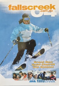
This publication was a major item in the Falls Creek marketing program for 2004. A major feature of 2004 winter season was the opening of Drover’s Dream, arguably Australia’s most picturesque chairlift. Taking over from Panorama Poma, the new four-seat high-speed chairlift would open up more top to bottom riding. This was a multi-million dollar resort investment and expanded the Sun Valley area. It was over 700 metres long and added an additional 7.4 hectares of beginner and intermediate terrain. It was predicted to reduce queues on the Towers Chairlift as it had a capacity of 2,400 riders per hour. XC Skiing was strongly promoted including Cross-Country Trail Passes, Lessons and Ski Hire available from Falls Creek Nordic Hire at Windy Corner, Gebi’s Ski Hire, Viking Ski Hire and Koki Ski Hire. Accommodation rates for 43 different venues were included. Corporate Partners in 2004 were Bilia Volvo, Nursing Australia, Milo and Ten TV, with Hewlett Packard sponsor of the Falls Creek Racing and Events Department.This booklet is significant because it documents seasonal activities at Falls Creek in 2004 and the opening of the Drover's Dream Chairlift.A glossy publication of 40 pages promoting Falls Creek all year round. It includes detailed information of activities at Falls Creek, images and advertising,falls creek activities 2004, drover's dream falls creek, falls creek marketing -
 Eltham District Historical Society Inc
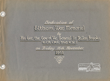
Photo album, Dedication of Eltham War Memorial by His Exc. the Governor of Vic., General Sir Dallas Brooks, K.C.B., C.M.G., D.S.O., K.StJ., on Friday 16th November, 1951, 1952c
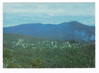
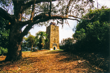
On November 11th 1929 the Shire of Eltham War Memorial Tower at Kangaroo Ground was opened. It is regarded as one of Melbourne’s most outstanding lookout towers. It commands a magnificent 360 degree panorama from Kinglake across the Diamond Valley to Macedon and the You Yangs. It is built on a peak which was once a volcano, 237 metres above sea level. After World War one a memorial cairn was erected on the site, and in 1925 a committee of public-minded citizens began to plan for a tower. Many generous donations of material and money were forthcoming so that in 1926 the Governor General Lord Stonehaven was able to unveil the plaque before a crowd of 500 people. There was some concern in the 1960s when the Forests Commission wanted to build a firespotters cabin on the top. At first R.S.L. branches opposed the idea, but it was realised that this use could combine with its use as a tourist attraction, and would ensure its maintenance for the future, Today the Kangaroo Ground tower provides one of the best views around Melbourne and is a fitting memorial to those who died in two world wars. From: Historic items for Diamond Valley Community Radio September 1990 (EDHS collection) Red hard bound binder, 2-ring holder; 18 grey coloured page inserts (3 blank) with 7 photos. Two pages of text in white paint. Also includes inserted leaves of manila card with photocopies of relevant news clippings pasted to card. An additional photo mounted on card dated 1952 has also been inserted into album.eltham, dedication, opening day, sir dallas brooks, kangaroo ground, war memorial, kangaroo ground tower -
 Eltham District Historical Society Inc
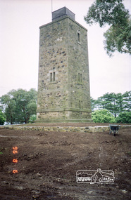
Photograph, Shire of Eltham War Memorial Tower, Memorial Park, Garden Hill, Kangaroo Ground Tower, 6 Aug 1996, 1996
On November 11th 1926 the Shire of Eltham War Memorial Tower at Kangaroo Ground was opened. It is regarded as one of Melbourne’s most outstanding lookout towers. It commands a magnificent 360 degree panorama from Kinglake across the Diamond Valley to Macedon and the You Yangs. It is built on a peak which was once a volcano, 237 metres above sea level. After World War one a memorial cairn was erected on the site, and in 1925 a committee of public-minded citizens began to plan for a tower. Many generous donations of material and money were forthcoming so that in 1926 the Governor General Lord Stonehaven was able to unveil the plaque before a crowd of 500 people. There was some concern in the 1960s when the Forests Commission wanted to build a firespotters cabin on the top. At first R.S.L. branches opposed the idea, but it was realised that this use could combine with its use as a tourist attraction, and would ensure its maintenance for the future, Today the Kangaroo Ground tower provides one of the best views around Melbourne and is a fitting memorial to those who died in two world wars. From: Historic items for Diamond Valley Community Radio September 1990 (EDHS collection) Roll of 35mm colour negative film, 7 stripsKodak Gold 100-5garden hill, kangaroo ground memorial, memorial park, shire of eltham war memorial tower, war memorial tower, war memorials -
 Eltham District Historical Society Inc
Photograph, View of Mount Macedon from the Shire of Eltham War Memorial Tower, Garden Hill, Kangaroo Ground, 1983, 1983
On November 11th 1926 the Shire of Eltham War Memorial Tower at Kangaroo Ground was opened. It is regarded as one of Melbourne’s most outstanding lookout towers. It commands a magnificent 360 degree panorama from Kinglake across the Diamond Valley to Macedon and the You Yangs. It is built on a peak which was once a volcano, 237 metres above sea level. After World War one a memorial cairn was erected on the site, and in 1925 a committee of public-minded citizens began to plan for a tower. Many generous donations of material and money were forthcoming so that in 1926 the Governor General Lord Stonehaven was able to unveil the plaque before a crowd of 500 people. There was some concern in the 1960s when the Forests Commission wanted to build a firespotters cabin on the top. At first R.S.L. branches opposed the idea, but it was realised that this use could combine with its use as a tourist attraction, and would ensure its maintenance for the future, Today the Kangaroo Ground tower provides one of the best views around Melbourne and is a fitting memorial to those who died in two world wars. From: Historic items for Diamond Valley Community Radio September 1990 (EDHS collection) Digital copy of colour photographfred mitchell collection, 1983, kangaroo ground, mount macedon, war memorial tower, shire of eltham war memorial tower -
Dutch Australian Heritage Centre Victoria
tourists bicycle pennants, mid 20th century
TourismHow people went on holiday. A memento of simple holidays. The tradition of camping as the holiday of choice.calico, triangular pennant. One edged in blue, the other in red.4089.R1 - blue edged pennant, showing the tourist sites around a place called Epen in the southern part of the province of Limburg. This is known because the name of the town is in large red letters. Three locations shown 1. Kamper Boerderij - A farm providing camping grounds. 2. Kasteel Beusdael - The Beusdael Castle 3. Wingbergermoelen - Wingberger Mill Also a little tent beneath the name of the town, with refers to the camping holiday. Also a maker's mark on the pennant, a small triangle with the letters L, A & B within it. 4089.R2 - red edged pennant, showing the area around Vaals in Limburg province, the name is in large red letters. The scene shows the meeting point between the Netherlands, Germany & Belgium - "Drie Landen Punt" (Three Country Meeting Point) Also shows the height of the viewing point (193m), as well showing other features including: - Hotel Bellevue - Uitzichttoren - viewing tower - Panorama Aken - Panorama of Aachen, Germany - Spoorbrug-Moresnet - Railwaybridge-Moresnet in Belgium. Small makers mark. Black triangle, possible the same as that shown in the other pennant, though obscured. -
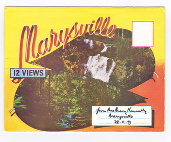 Marysville & District Historical Society
Postcard (item) - Colour photographs, Murray Views, Marysville 12 Views, 1950's
A fold out postcard of 12 colour photographs of scenes and landscapes in and around Marysville in Victoria.A fold out postcard 12 colour photographs of scenes and landscapes in and around Marysville in Victoria. These photographs were produced by Murray Views in Gympie, Queensland as a souvenir of Marysville.Marysville/ 12 VIEWS from Mrs Mary Keneally/ Marysville/ 28.11.91 PRODUCED BY MURRAY VIEWS./ GYMPIE./ Q COPYRIGHT SAMUEL LEE & CO., PRINTERS. STEAVENSON'S FALLS, MARYSVILLE, VIC. TOURISTS AT MARYSVILLE, VIC. "FRUIT SALAD FARM", MARYSVILLE MAIN STREET, MARYSVILLE, VIC. ROAD SCENE, MARYSVILLE, VIC. THE CROSSWAYS, MARYSVILLE, VIC ROAD TO CUMBERLAND VALLEY, MARYSVILLE PANORAMA FROM BLACK SPUR, MARYSVILLE ROAD, MARYSVILLE, VIC. NICHOLL'S LOOKOUT, MARYSVILLE, VIC. TREE FERNS, MARYSVILLE, VIC. THE BRIDGE, MARYSVILLE, VIC.steavenson falls (image 1), tourists in marysville (image 2), taggerty river (image 3), fruit salad farm (image 4), main street marysville (image 5), road scene marysville (image 6), the crossways (image 7), cumberland valley (image 8), black spur (image 9), nicholl's lookout (image 10), tree ferns (image 11), bridge (image 12), marysville, victoria, postcard, souvenir, murray views -
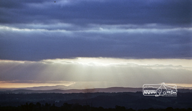
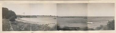 Phillip Island and District Historical Society Inc.
Photographs, 11/1946
Part of a collection of photographs donated by Julie Barnett. Photographs taken by Julie's In-law's whilst on their honeymoon in November 1946.229-50. Black & White panorama of 4 photographs joined together of Westernport from San Remo looking towards Newhaven. Piers with bridge in background & boats in the bay. 229-51. Black & White photograph of Shelly Beach. 229-52. Black & White photographs (2 pasted together) of Inverloch Inlet. 229-53. Black & White photograph of Westernport with S. S. Reliance in the bay. 229-54. Black & White photograph of a Sea bird sitting on top of a pole. 229-55. Black & White photograph of the Chapel at St. Paul's Training School in Newhaven, Phillip Island. 229-56. Black & White photograph of the Summerland Jetty and coastline. 229-57. Black & White photograph of a Corvette in Westernport Bay. Trees in foreground and man walking on the beach. 229-58. Black & White photograph of Westernport looking towards French Island. 229-59 to 229-62. Black & White photographs of a Koala in a tree.westernport bay, westernport, shelly beach, inverloch inlet, s.s.reliance, wildlife - seabirds, seagull, st. paul's training school newhaven, phillip island, chapel at st. paul's training school, summerland jetty phillip island, corvette westernport bay, wildlife - koala, koala -
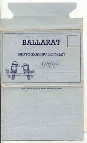 Ballarat Tramway Museum
Postcard - Folder set, Valentine & Sons Publishing Co, "Ballarat Photographic Booklet", 1940's
Shows views of the Ballarat CBD and nearby features in the 1930's and 1940's of views of Ballarat, including some trams in the photographs. Demonstrates production of souvenirs of the era - folded postcards. The photos could also be used for individual postcards.Set of 9 black and white views of Ballarat printed on a folded strip, glued within a blue colour light weight cardboard folder, titled "Ballarat Photographic Booklet". Booklet printed with an address area with title and kookaburras. Produced by The Valentine Publishing Co. Pty Ltd Melbourne & Sydney The rear has a slit on the rear cover that allowed the folder to be secured. Pictures are: 1. Panorama from Sturt Street, looking up Bridge St 2. City Hall 3. The Avenue of Honour (14 Miles Long) 4. Lake Wendouree 5. King George V. Memorial 6. The Pergola, Botanical Gardens 7. Eureka Stockade 8. Lydiard Street, showing Craig's Hotel 9. Sturt Street, Ballarat. Made during 1940, with photographs of the 1930's as well given motor cars in the photo. Has a date of "5/10/1951" on the front cover in ink. Has a date of "5/10/1951" on the front cover in ink.trams, tramways, sturt st, town hall, lake wendouree, memorial arch avenue of honour, memorial, gardens, lydiard st, eureka -
 Marysville & District Historical Society
Postcard (item) - Colour postcard, Nucolorvue Productions Pty. Ltd, MARYSVILLE-Victoria, Pre 2009
A colour photograph of the view of Marysville from the Cumberland Range.A colour photograph of the view of Marysville from the Cumberland Range.The Cumberland Valley is notable for its giant mountain ash (Eucalyptus regnans) trees within the Cumberland Memorial Scenic Reserve, and relics from former sawmills and gold mining. The Big Culvert is located nearby on the Marysville-Woods Point Road, which was historically part of the Yarra Track. Cambarville, which is in the Cumberland Valley, was established as a timber mill town in the 1940s. Timber mill owners A Cameron and FJ Barton named Cambarville. They established the mill to salvage timber from trees destroyed in the 1939 bushfires. Cambarville was impacted by the 2009 Black Saturday bushfires and any remaining structures were destroyed. Barton's Lookout was named after a member of the Barton Family who were amongst Marysville's earliest pioneering families. This postcard was produced by Nucolorvue Productions as a souvenir of Marysville.Panorama of Marysville from/ Cumberland Range. NU-COLOR-VUE/ OF/ AUSTRALIA NUCOLORVUE PRODUCTIONS PTY. LTD./ COPYRIGHT PRINTED IN AUSTRALIA NCV 1658 POST CARD Dear Anne & tribe,/ Well as you can see,/ I'm here at Marysville./ This little surprise/ was waiting for me/ at the airport. We're/ here for a few days,/ & it's in the mountains/ outside Melb./ Traditionally it's/ a spot for Honeymooners./ There are lots of/ bush tracks &/ places to see and/ the hotel has a pool./ The weather is hot,/ 42 today so it/ is lovely to be out/ of Melb./ bye for now/ all my love/ illegiblemarysville, barton's lookout, victoria, nucolorvue productions, postcard, souvenir, cumberland valley, cumberland memorial scenic reserve, big culvert, marysville-wood's point road, yarra track, mining, timber mills, a cameron, fj barton, cambarville, 1939 bushfires, 2009 black saturday bushfires -
 Flagstaff Hill Maritime Museum and Village
Postcard - Postcard Folder, scenes, George Rose, Rose Stereographic Company, Rose Series, Picturesque Views of Warrnambool Australia, 1880-1942
GEORGE ROSE 1861-1942: - George Rose was a well-known Victorian photographer, famous for his late 19th and early 20th century photography. He was born in Clunes, Victoria, and was in his 20th year when he founded Rose Stereograph Company in 1880. He took the opportunity of a popular trend of the times to produce stereographs, pairs of almost duplicate photographs that appeared in 3D when viewed in a handheld stereo viewer. By the 1920s, these lost their popularity, so he used his photographic skills to produce cards and postcards of scenes and people. The twelve photographs in the Rose postcard folders include locations connected to other items in our Collection, including the Valentine postcard folder in this set. The photographs are titled: - . The Avenue and War Memorial. Warrnambool. Vic. . The Blow-hole. Thunder Point. Warrnambool. Vic. . Botanical Gardens. Warrnambool. Vic. . Eagle Rock. Warrnambool. Vic. . The New Concrete Bridge and Breakwater. Warrnambool. Vic. . Liebig Street. Warrnambool. Vic. . Looking to Thunder Point. Warrnambool. Vic. . The Beach. Warrnambool. Vic. . Hopkins Falls. Warrnambool. Vic. . Shelly Beach. Warrnambool. Vic. . The Mouth of the Hopkins River. Warrnambool. Vic. . Panorama of Warrnambool, Vic. [Kepler Street towards Presbyterian Church on Spence St] This postcard folder shows scenes and places of interest in and around Warrnambool. The George Rose postcard folders in this set were produced in Victoria and include pictures taken by the renowned photographer between 1880 and 1942. Other postcards in our collection have photographs of the same or similar locations at different periods in time. Each postcard records a moment in history and is significant as a way to compare and show the changes in the local environment and community, building a story of the local history. The images record changes in the coastline, land, bay, buildings and other structures, roads, transportation and even the fashions of the times. This copy folder is one of a set of three. This folder has a green-grey textured rectangular card cover with a sketch of a rose on the front. The cover also contains the name of the postcard series, the location of the series' focus, the producer's details, and lines for adding an address. The folded cover contains a long, concertinaed page with six titled photographs on each side, totalling twelve. The folder contains scenes from Warrnambool and nearby popular areas, including Lady Bay, the Port of Warrnambool, the Warrnambool Breakwater, the Viaduct, the Merri River Footbridge, the Hopkins River Mouth, and Proudfoot’s and the Fanny Nelson/Flett boathouses. The cover has a sketch of a rose and inscriptions. The lithograph photographs were taken between 1880 and 1942 by well-known Victorian photographer George Rose, Rose Stereograph Company of Armadale, Victoria.Image: [Rose with rosebud and leaves] Printed: "Rose Series / Picturesque Views of / WARRNAMBOOL / AUSTRALIA" "PUBLISHED BY / ROSE STEREOGRAPH CO / ARMADALE. VIC."flagstaff hill maritime museum and village, great ocean road, shipwreck coast, warrnambool, flagstaff hill, flagstaff hill maritime museum, flagstaff hill maritime village, warramble, postcard, postcard folder, warrnambool scenes, picturesque views of warrnambool, lady bay, port of warrnambool, breakwater, warrnambool breakwater, viaduct, merri river footbridge, merri river suspension bridge, suspension footbridge, merri river mouth, hopkins river mouth, proudfoot's, fanny nelson, nelson's boatsheds, nelson's boathouse, boathouse, hopkins river boathouses, flett's boathouse, flett, george rose, image of a rose, rose series, rose stereograph co, rose stereographic company, lighograph, armadale victoria, lady bay beach, beach scene, lower light, concrete footbridge, 1922 footbridge, viaduct road, rose postcard, new concrete bridge, 1945, 1890, 1922, small footbridge, 1872 footbridge, 1872, merri river estuary, stingray bay, postcards, green-grey postcard folder, shipwrecked coast, maritime museum, souvenir, warrnambool local scenes, photography, local history, tourism, photographs, visitors, travel, scenes, mid-20th century, 1940s, 1950s, concertina fold, z-fold, 1880s, collection, correspondence, rose stereograph co armadale, victorian photographer, soldiers’ memorial, hopkins river, the cliffs at shelly beach, the road to sandy beach, pier, botanic gardens, post office, municipal buildings, merri river, proudfoot’s -
 Flagstaff Hill Maritime Museum and Village
Postcard - Postcard Folder, scenes, George Rose, Rose Stereographic Company, Rose Series Picturesque Views of Warrnambool Australia, 1880-1942
GEORGE ROSE 1861-1942: - George Rose was a well-known Victorian photographer, famous for his late 19th and early 20th century photography. He was born in Clunes, Victoria, and was in his 20th year when he founded Rose Stereograph Company in 1880. He took the opportunity of a popular trend of the times to produce stereographs, pairs of almost duplicate photographs that appeared in 3D when viewed in a handheld stereo viewer. By the 1920s, these lost their popularity, so he used his photographic skills to produce cards and postcards of scenes and people. The twelve photographs in the Rose postcard folders include locations connected to other items in our Collection, including the Valentine postcard folder in this set. The photographs are titled: - . The Avenue and War Memorial. Warrnambool. Vic. . The Blow-hole. Thunder Point. Warrnambool. Vic. . Botanical Gardens. Warrnambool. Vic. . Eagle Rock. Warrnambool. Vic. . The New Concrete Bridge and Breakwater. Warrnambool. Vic. . Liebig Street. Warrnambool. Vic. . Looking to Thunder Point. Warrnambool. Vic. . The Beach. Warrnambool. Vic. . Hopkins Falls. Warrnambool. Vic. . Shelly Beach. Warrnambool. Vic. . The Mouth of the Hopkins River. Warrnambool. Vic. . Panorama of Warrnambool, Vic. [Kepler Street towards Presbyterian Church on Spence St] The photographs in this postcard folder were taken between 1880 and 1942 by the renowned Victorian photographer George Rose. The locations match photographs and postcards in our collection that were taken at different times. A comparison between them shows the changes over time in the land and bay, the buildings and other structures, transportation and even the fashions of the times, building the story of our local history.Postcard folder, Rose Series, blue cover. One of a set of three containing images of Warrnambool and district before 1942. Green folder, textured cardboard folder containing a Z-folded strip of white matte photographic paper with six black and white photographs on each side. Titles are printed below the images. The folder is secured by placing two tabs into two slots on the back cover to hold the cover in place and create an envelope shape. Three horizontal lines are printed on the front for the receiver’s address. There is a logo of a long-stemmed rose on the left side and inscriptions on the front cover. The lithograph photographs were taken between 1880 and 1942 by well-known Victorian photographer George Rose and published by Rose Stereograph Company of Armadale, Victoria. The folder contains scenes of popular areas at Warrnambool and nearby locations including Lady Bay, the Port of Warrnambool, the Warrnambool Breakwater, the Viaduct, the Merri River Footbridge, the Hopkins River Mouth, and Proudfoot’s and the Fanny Nelson/Flett boathouses. Image: [Rose with rosebud and leaves] Printed: "Rose Series / Picturesque Views of / WARRNAMBOOL / AUSTRALIA" "PUBLISHED BY / ROSE STEREOGRAPH CO / ARMADALE. VIC." flagstaff hill maritime museum and village, great ocean road, shipwreck coast, warrnambool, flagstaff hill, flagstaff hill maritime museum, flagstaff hill maritime village, warramble, postcard, postcard folder, warrnambool scenes, picturesque views of warrnambool, picturesque views of warramble, lady bay, port of warrnambool, breakwater, warrnambool breakwater, viaduct, merri river footbridge, merri river suspension bridge, suspension footbridge, merri river mouth, hopkins river mouth, proudfoot's, fanny nelson, nelson's boatsheds, nelson's boathouse, boathouse, hopkins river boathouses, flett's boathouse, flett, george rose, image of a rose, rose series, rose stereograph co, rose stereographic company, lighograph, armadale victoria, lady bay beach, beach scene, lower light, concrete footbridge, 1922 footbridge, viaduct road, rose postcard, new concrete bridge, 1945, 1890, 1922, small footbridge, 1872 footbridge, 1872, merri river estuary, stingray bay, postcards -
 Eltham District Historical Society Inc
Photograph, War Memorial Tower, Kangaroo Ground
View of Kangaroo Ground Tower from the entrance gate area beside the footpath (Contained in an album originally put together by Harry Gilham. Photos subsequently relocated to photosafe archival storage.) On November 11th 1926 the Shire of Eltham War Memorial Tower at Kangaroo Ground was opened. It is regarded as one of Melbourne’s most outstanding lookout towers. It commands a magnificent 360 degree panorama from Kinglake across the Diamond Valley to Macedon and the You Yangs. It is built on a peak which was once a volcano, 237 metres above sea level. After World War one a memorial cairn was erected on the site, and in 1925 a committee of public-minded citizens began to plan for a tower. Many generous donations of material and money were forthcoming so that in 1926 the Governor General Lord Stonehaven was able to unveil the plaque before a crowd of 500 people. There was some concern in the 1960s when the Forests Commission wanted to build a firespotters cabin on the top. At first R.S.L. branches opposed the idea, but it was realised that this use could combine with its use as a tourist attraction, and would ensure its maintenance for the future, Today the Kangaroo Ground tower provides one of the best views around Melbourne and is a fitting memorial to those who died in two world wars. From: Historic items for Diamond Valley Community Radio September 1990 (EDHS collection) Colour photographgarden hill, kangaroo ground, memorial park, shire of eltham war memorial, shire of eltham war memorial tower, war memorial tower -
 University of Melbourne, Burnley Campus Archives
Album - Colour prints, negatives and 35mm slides, Staff, Collection of Photographs Used by Staff, 1994-2000
Collection of photographs in envelopes which had belonged to staff members. Some are photographs from excursions, others are teaching material, plants. Some labelled: 1. Ruth Upper Merri Creek - negatives and prints; Merri Creek - negatives and prints; Merri Creek Panorama - prints; Merri Creek Posters 1995 - negatives and prints; Plants - negatives. 2. Western District Exhibition, labelled - negatives and prints of paintings; Mt Ridley (Excursion?) - negatives and prints; Energy Education Centre 15 November 1995; Gardens - Spring 1995 negatives (mostly James Hitchmough, Native Grasslands and Luffmann Ponds) Scanned; Student Party June 1994 - negatives; 3. Pot Trial - negatives and prints; Miscellaneous plant trials, Centenial Centre Shop, Arborists, Plants, Excursions - negatives; Excursions , 1 year 2000 - negatives and prints; Orchard (older) - black and white negatives and prints; Arborists - negatives and prints; 4. Staff, Graduate students - negatives and prints; Miscellaneous: Plants, - negatives, slides and prints. 7. Native Garden and other garden views - prints and negativesstaff, excursions, teaching material, merri creek, mt ridley, energy education centre, student party, pot trial, centenial centre shop, arborists, plants, graduates, students, plant database, jill kellow, orchard, james hitchmough grasslands, horticulture shop, ruth beilin, upper merri creek, merri creek panorama, merri creek posters