Showing 2310 items matching "parish"
-
 Eltham District Historical Society Inc
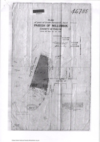
Document - Photocopy, Survey Fleld Notes of Part of Crown Portion 13, Section 4 at Eltham, Parish of Nillumbik, County of Evelyn, 7 May 1925
Portion of land bounded by: Main Road, Eltham Railway Station Application 46785 J.T. Robinson, Surveyor, 7 May 1925application 46785, arthur street, bible street, eltham, eltham railway station, luck street, main road, map, survey plan -
 Eltham District Historical Society Inc
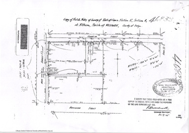
Document - Photocopy, Survey Fleld Notes of Part of Crown Portion 12, Section 4 at Eltham, Parish of Nillumbik, County of Evelyn, 30 September 1925
Portion of land bounded by: Main Road, Franklin Street, Bible Street, Brougham Street Application 46839 R. Woodcock, Licensed Surveyor, 30 September 1925application 46839, bible street, brougham street, eltham, franklin street, main road, map, survey plan -
 Eltham District Historical Society Inc
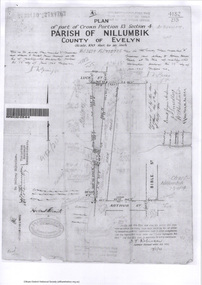
Survey Fleld Notes of Part of Crown Portion 13, Section 4 at Eltham, Parish of Nillumbik, County of Evelyn, 17 May 1926
Portion of land bounded by: Eltham Railway Station, Main Road, Luck Street, Arthur Street Application 4182/215 J.T. Robinson, Licensed Surveyor, 17 May 1926application 4182/215, arthur street, eltham, eltham railway station, luck street, main road, map, survey plan -
 Eltham District Historical Society Inc
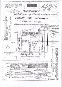
Document - Photocopy, Survey Fleld Notes of Part of Crown Portion 12, Section 4 at Eltham, Parish of Nillumbik, County of Evelyn, 18 March 1926
Portion of land bounded by: Main Road, York Street, Bible Street, Bridge Street Application 46906 R.H. Woodcock, Licensed Surveyor, 18 March 1926application 46906, bible street, bridge street, eltham, main road, map, survey plan, york street -
 Eltham District Historical Society Inc
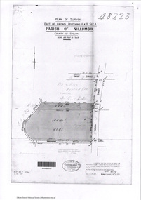
Document - Photocopy, Survey Fleld Notes of Part of Crown Portions 12 & 13, Section 4 at Eltham, Parish of Nillumbik, County of Evelyn, 6 May 1929
Portion of land bounded by: Main Road, York Street, Diamond Creek, Swan Street Application 48223 P.N. Guy, Licensed Surveyor, 6 May 1929application 48223, diamond creek (creek), eltham, main road, map, survey plan, swan street, york street -
 Eltham District Historical Society Inc
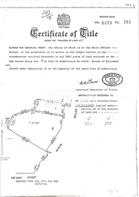
Document, Photocopy of Certificate of Title, Eltham War Memorial Trust, Lot 2, Plan of Subdivision No. 63242, Parish of Nillumbik; derived from Vol. 7073 Fol. 498, 18 May 1964, 1964
A4 photocopy Also Shire of Eltham plan of site with proposed security fence highlighted, c.1970 And Plan of Eltham Activity Centre, c.2010certificate of title, eltham war memorial, eltham war memorial trust -
 Marysville & District Historical Society
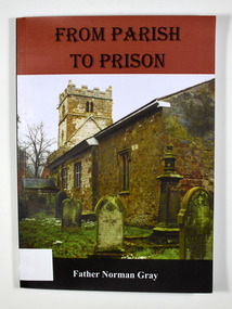
Book, From Parish to Prison
Paperback. Front cover has a colour photograph of the outside of a church with five headstones in the foreground.To Marysville Historical / Society / With every blessing / From Father Norman / 8th Feb 2014 Stamp of Marysville & District / Historical Society Inc / P.O. Box 22 / Marysville 3779anglican church, anglican girls' grammar school, pentridge prison -
 Federation University Historical Collection
Plan, Crown Lands Department Melbourne, Parish of Clarkesdale, County of Grenville
Geolgical plan.clarkesdake, berringa, staffordshire reef, piggoreet -
 Federation University Historical Collection
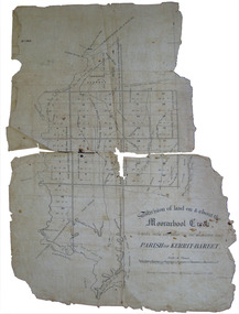
Plan, Eugene Bellairs, Moorabool Creek, Parish of Kerrit-Bereet, 01/08/1855
Plan of the Moorabool Creek on the Melbourne Roadmoorabool, kerrit-bareet, moorabool creek, eugene bellairs -
Phillip Island and District Historical Society Inc.
Book, DICKENS, Charles, Oliver Twist, or, the Parish Boy's progress ; Great expectations
Stamped 'Cowes Free Public Library'. Labelled 'Cowes Free Public Library', 'Phillip Island Historical Society, Cleeland Bequest'. -
 Greensborough Historical Society
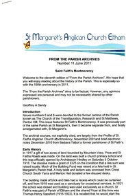
Magazine - Newsletter, St Margaret's Anglican Church Eltham, St Faith's Montmorency: from the Parish Archives Number 11 June 2011, 11/06/2011
History of St Faith's Montmorency4 p. text and colour photographst faith's montmorency, st margaret's anglican church eltham -
 Greensborough Historical Society
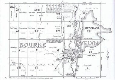
Map, Dianne Edwards, Part of Parish of Yan Yean 1878, 1978
Map includes Crown Portions V - XVII, showing Yan Yean Reservoir, Melbourne-Whittlesea Railway route, names of landowners, roads and various other features west of Greensborough Road. Redrawn by A. R. Blair in 1978.1 p. black and white photocopy of mapyan yean reservoir, yan yean -
 Greensborough Historical Society
Photograph, St Mary's Parish Primary School Gr1539 1964 Grade 3A, 1964_
A black and white photograph of St Mary's Primary School Greensborough 1964, Grade 3AA black and white photograph of St Mary's Primary School Greensborough 1964, Grade 3A -
 Eltham District Historical Society Inc
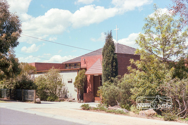
Photograph, Marjorie North, St Francis Xavier Parish Church, Mayona Road, Montmorency, 1985, 1986
Negatives supplied by Marjorie North 1 July 1986 for Montmorency France albumRoll of 35mm colour negative film, 3 stripsKodak CL 200 5093montmorency, st francis xavier parish, mayona road, church -
 Ringwood and District Historical Society
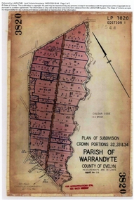
Document, Titles of land subdivision, Crown Portions 32, 33 & 34, Parish of Warrandyte, 1884 and 1907, Ringwood, Victoria
Evolution of the subdivision and the use of landBlack plastic bound pockets containing copies of 18 LANDATA subdivision maps and mortgage transfer pages dating from 1884 for 303 acres 2 roods and 1 perch bounded by Warrandyte Road, Wonga Road, Oban Road and Mullum Mullum Creek in Ringwood, Victoria. Certificates of Title include Vol 1606 Fol 045 Frederick Walter Purches 1884 and subsequent transfers to 1902, and Vol 3232 Fol 646357 Ann Jane Kennedy 1907 and transfers to 1921. -
 Ringwood and District Historical Society
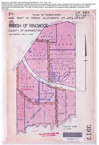
Document, Sale of Land Act documents - Part of Crown Allotments 14A, 40A, 40B & 4C, Parish of Ringwood - 1895
Certificate of Title - Georgina Elizabeth Wingfield Knox, wife of William Robert Knox, part of allotments 14A and 40A, 27th November, 1895, and subsequent transfers up to 1959. Plan of Subdivision includes Allens Road, The Greenway, Dickasons Road, and Canterbury Road, Ringwood. (With further residential and commercial developments taking place since the 1920s, this area became part of the suburb of Heathmont.) -
 Ringwood and District Historical Society
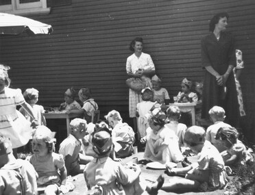
Photograph, 1950 - Parish Hall Xmas Party, Church of England, Ringwood Street, Ringwood. Mrs. Linda Evans and Mrs. Gray
Typed below photograph, "1950 - Mrs. Linda Evans, Mrs. Gray". -
 Ringwood and District Historical Society
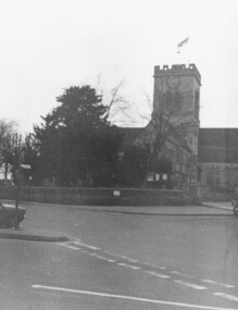
Photograph, Parish Church of St. Peter and St. Paul in Ringwood, Hampshire, England
Church in Ringwood, EnglandWritten below photograph, "Church Ringwood England" -
 Federation University Historical Collection
Document, Report on Parish of Haddon, 1898, 1898
Ferdinand Krause was a lecturer at the Ballarat School of Mines.1 double sided printed page with 2 geological diagrams.haddon, ferdinand krause -
 Federation University Historical Collection
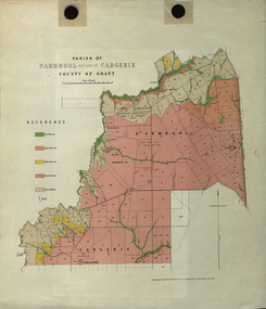
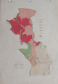
Plan - Map, Mines Department, Parish of Narmbool and part of Cargerie, County of Grant, 1892, 06/1992
This map shows the position of the homestead on the Narmbool Pre-emptive Right, volcanic craters, stock reserve, quarry and geological eras,Geological map showing Narmbool and part of Cargerie in the County of Grant in five colours, predominantly pink.narmbool, cargerie, narmbool pre-emptive right, williamson's creek, leigh river, green hill, collyer's hill, volcano, crater, krause, ferdinand krause -
 Federation University Historical Collection
Plan, Plan of Survey Crown Allotment 9A and Part of Crown Allotment 8 Section 10 City and Parish of Ballaarat, after 1929
ink and watercolor on watermarked laid paper dated 1928text and measurementsballaraat, ballarat, plan, plan of survey, armstrong street, skipton street -
 Federation University Historical Collection
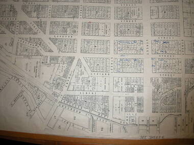
Plan, Ballaarat City Parish Plans, 1931, 09/03/1931
Large Scale plans showing streets, allotments, dimensions, crown grantees, dates granted, etc Sheet 2: Sturt Street, Rubicon Street, Pryor Street, Humffray Street, Sebastopol Street, Armstrong Street South, Fraser Street, Hickman Street ballarat, ballaarat, plans, city of ballarat -
 Federation University Historical Collection
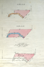
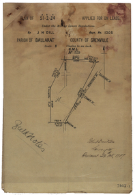
Plan, Parish Of Ballarat Mining Lease applied for by J.H. Dill, 1907, 24/10/1907
Removed from Catalogue No 3601.Lease, plan and field notes showing the survey for the New Kohinoor Comapny Lease No 1205. Scale: 8 chains to 1 inch (1:6336)new kohinoor, survey, robert davidson, j.h. dill, dill, mining, ballarat, new koh-i-nor -
 Federation University Historical Collection
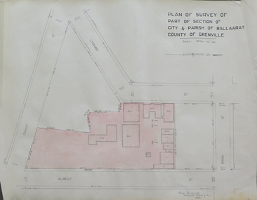
Plan, Plan of Survey of Part of Section 9A City & Parish of Ballarat County of Grenville (Albert Street frontage), 1932
The M.B. John Trade Building was built on the Albert Street Frontage..1) Plan of SMB showing Albert, Grant, Lydiard and Dana streets, on paper with colored highlights undertaken by Ballarat School of Mines student George Murrowood in 1932 .2) Hand written page by George Murrowood, of technical description of land surveying Grade II 1932ballarat school of mines, surveying, george murrowood, albert street, alumni, m.b. john building, architectural plan -
 Federation University Historical Collection
Plan, Parish of Dowling Forest, County of Ripon and Grenville, 19
Scale [1:31 680]. 40 chains to 1 in.Geological map on a cadastral base, showing the occurence of reefs, and alluvial deposits. Relief shown by contours.dowling forest, wyndholm, wyndholm pre-emptive right, miners rest, ballarat racecourse, winter's swamp, police reserve, miner's rest, winters swamp, geology -
Federation University Historical Collection
Plan, Nick O'Time Lead, Parish of Tarnagulla
A3 Photocopy of the Nick'O'Time Leadplan, mining, cgt, tarnagulla, nick o'time -
 Federation University Historical Collection
Plan, Parish of Lal-Lal County of Grant
Printed colour map on paperlal lal, mt doran, lal lal racecourse, geology, geological, moorabool river, mount duran -
Federation University Historical Collection
Report, Report on Parish of Carngham, 1898, 1898
Foolscap report by Ferdinand Krause, issued by James Travis, Acting Secretary for Mines. carngham, ferdinand krause, department of mines -
 Federation University Historical Collection
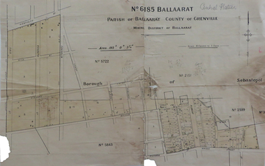
Map, No 6185 Ballaarat Parish of Ballaarat County of Grenville, not dated
Printed map with pencil inscriptionsmap, parish of ballaarat, grenville county, sebastopol, central company engine house, wesleyan reserve, victoria street, yarrowee street, charlotte st, kyle street -
 Federation University Historical Collection
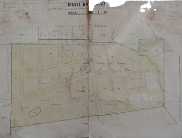
Map, No 6817 Ballaarat, Parish of Ballaarat, Mining District of Ballaarat, c1908
Printed map with pencil inscriptions on recto and versomap, mining districts, mining district of ballaarat