Showing 2028 items matching "planning document"
-
 Eltham District Historical Society Inc
Work on paper (item) - Photograph, 2 Metery Road, Eltham South
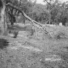
Robert and Ada Zull built an Alistair Knox designed house at 2 (lot 8) Metery Road, Eltham, a one acre property for their family of five in the mid 1960s. This series of photographs show the bush block before construction, concrete footings and base being poured and the timber frame takes shape. The house had a concrete floor. Susan Bennett, nee Zull's reminiscences are published in EDHS Newsletter, February and April 2020. ".. the block was big.. Building the house was slow going. The plans had to be discussed, then drawn up, finance found, council permits obtained and labourers engaged. "This series of photographs together with the account of personal remiscences provide a unique document of the construction of an Alistair Knox designed home. Knox was a pioneer in the use of mudbricks and recycled materials and is significant to his contribution of this style of architecture in Eltham and the wider Shire of Nillumbik.zull family, eltham south, 2 metery road, alistair knox, footings, concrete, concrete mixer, frame, bush block, fj holden standard sedan -
 Eltham District Historical Society Inc
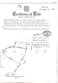
Document, Photocopy of Certificate of Title, Eltham War Memorial Trust, Lot 2, Plan of Subdivision No. 63242, Parish of Nillumbik; derived from Vol. 7073 Fol. 498, 18 May 1964, 1964
A4 photocopy Also Shire of Eltham plan of site with proposed security fence highlighted, c.1970 And Plan of Eltham Activity Centre, c.2010certificate of title, eltham war memorial, eltham war memorial trust -
 Eltham District Historical Society Inc
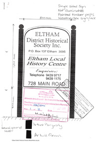
Document - Folder, Application for a street sign, 1999-2000
Folder 67 of the Harry Gilham Collection. Folder includes information and some duplication relating to the installation of a sign in front of 728 Main Road, Eltham by Eltham District Historical Society. Includes newsletter no 138, design of sign and related wording on sign, quotation by John Sharp Signs, Eltham, notes and planning permit submitted to Nillumbik Shire Council, and associated plans 1999-200030 pages in manilla foldereltham district historical society, planning permit, signage, john sharp signs, local history centre -
 Eltham District Historical Society Inc
Document - Folder, Eltham Town Focus Group, 1996-1997
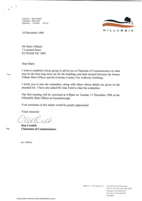
Documents relating to a focus group brought together by the Shire of Nillumbik Chairman of Commissioners in 1996 to provide advise on the best long term use for the buildings and land situated between the former Eltham Shire Offices and Country Fire Authority buildings. These buildings are known as the Eltham War Memorial buildings located at 903-907 Main Road, Eltham. In May 2020, the Heritage Council Victoria did not recommend the site for inclusion in the Victorian Heritage Register. 11 pagesharry gilham collection, consultation, planning, eltham, eltham war memorial, eltham war memorial buildings, commissioners -
 Federation University Historical Collection
Document - E.J. Barker Papers, Papers collected by E.J. Barker Related to School of Mines Ballarat and Ballarat Institute of Advanced Education Merger
E.J. Barker is a past principal of the School of Mines Ballarat and the Library at the Mt Helen Campus is named after him. School of Mines is a predecessor of Federation UniversityCorrespondence, Reports, Plans, Newspaper articles, Newsletters, notes and other papers from various institutions and Government departments relating to the merger school of mines ballarat, e.j. barker, merger report, approach to a merger, merger, d. woolley, scv/vic joint committee, scv, vic, ballarat institute of advanced education, state college of victoria, education advisory committee, minster for education, councils of colleges, academic committee, the age, uni must employ surplus staff, university boycott campaign, committees of council, enrolments, master plan soon for new state college, new principal for state college, bendigo advertiser, early decision expected on amalgamation, b.i.t and state college will be merged, f.j. rogers, j.a. chisholm, state college will build, tertiary planning in state of chaos, phone message, victoria institute of colleges, t. swanson, j. ryan, r. mcmullen, r. hinkley, commission on advanced education, newsletter, bendigo institute of technology, dr. law, r.w. birrell, colleges head for merger, mr mcdonnell, tender recommended, k.g. scarrott, r.w wirrell, r.e parry, enrolment forecasts, monash reporter, mt helen campus plan, notes, submission to the minister, report, choice of umbrella body, education merger sound, city of ballarat, i.c smith, australian universities commission, education department, ballarat institute of advanced education staff association, k.l jennings, multi-campus institutions, corporate nature of councils, future development, comments on merger, umbrella organisations -
Federation University Historical Collection
Document - SMB Documents E.J. Barker, Various School of Mines Ballarat Papers collected by E.J. Barker
E.J. Barker is a past principal of the School of Mines Ballarat and the Library at the Mt Helen Campus is named after him. School of Mines is a predecessor of Federation UniversityLetters, Reports Plans, Ephemera and Clipboard associated with E.J. Barker and the School of Mines Ballaratplanning requirements, individual rooms, dr ron wild, school of mines and industries ballarat, institute profile, location map, university of ballarat, campus plan, great hall/arts complex, notes, 1970-72 building program, operations and decisions, report to council, visit by principal, priorities, electrical engineering, mt helen, minutes of special council meeting, university of melbourne, engineering, mt helen development report, administration building, technical art school, former ballarat gaol, the court house, smb community centre, trust news, articles, discovery day, k.j. flecknoe, retirement, membership of sub committee, n.a crouch, e.j. barker, k.l. cross, w.j. gribble, l.f.j. hillman, r.c lovett, d. nicholson, g. robertson, p.r. shiells, b. tanner, r. feary, i. harris, b.c. mclennan, m. stevens, t.a. wiseman, d.r. bolster, p.h. dixon, r. dunlop, r. furness, e.j. lumsdon, a. mccaffrey, p.r. davies, d. farnsworth, j. harrison, k. mcfarlane, j. mills, s.a. mendelson, i. robinson, d.j. fraser, j. van dreven, k. alsop, b. bridges, m. palmer, r. sutton, l. snibson, h. van hammond, t. runnalls, p. sculley, g. shearer, t. slater, michael ronaldson, robert lovett, edward john barker, e.j. barker building, council membership, clipboard, n.g curry, state college of victoria, articles of association, memorandum, australian conference of principles of colleges of advanced education, commonwealth ministerial working party, victorian post secondary education commission, australian institute of physics symposium, royal australian institute of public administration, premier of victoria, r.j. hamer, m.b. john, new south wales institute of technology, phone messages, peter o'loughlin, annual report, signing of agreement, position description, certificates, fifth form -
Federation University Historical Collection
Document - Fourth University, Documents relating to a Fourth University for Victoria collected by E.J. Barker
E.J. Barker is a past principal of the School of Mines Ballarat and the Library at the Mt Helen Campus is named after him. School of Mines is a predecessor of Federation UniversityVarious Letters, Reports Newspaper articles and notes collected by E.J. Barker on the proposed Fourth University for Victoria victorian institute of colleges staff association, r.w. hinkley, e.j. barker, ballarat institute of advanced education, vicsac, fourth university, summary, k.l jennings, mr swanson, australian universities commission, plea on varsity staff rejected, list of visitors, professor p.h. karmel, professor f.b. bull, sir ernest coates, dr w.l. hughes, sir samuel jones, professor a.r. main, professor p.h. partridge, r.a. simpson, professor sir sydney sunderland, t.b. swanson, r.h. arthur, a. freebody, sir willis h. connolly, l.h.s. thompson, geelong advertiser, newspaper articles, the age, i.c. smith, city of ballarat, j.a chisholm, 16 named to plan fourth university, newsletter, report, future developement of tertiary education, summary of statements, education age, m.b. john, tertiary education advisory council, a.s buchanan, the chartered engineer, dr. d.m. myers, r. law, victorian institute of colleges, a.s. craig, meetings, mr hamer, h.p. mason, bendigo institute of technology, mary p. lawn, k.d. green, premiers department, recommendations, k. beazley, a.m mackinnon, gordon institute of technology, e. szomanski -
 Federation University Historical Collection
Document - Document - Correspondence, VIOSH: Correspondence between Ballarat College of Advanced Education and The College of Occupational Medicine, 1984
Victorian Institute of Occupational Safety and Health (VIOSH) Australia is the Asia-Pacific centre for teaching and research in occupational health and safety (OHS) and is known as one of Australia's leaders on the field. VIOSH has a global reputation for its innovative approach within the field of OHS management. VIOSH had its first intake of students in 1979. At that time the Institution was known as the Ballarat College of Advanced Education. In 1990 it became known as Ballarat University College, then in 1994 as University of Ballarat. It was 2014 that it became Federation University. VIOSH Australia students are safety managers, senior advisors and experienced OHS professionals. They come from all over Australia and industry. Students are taught active research and enquiry; rather than textbook learning and a one-size fits all approach. VIOSH accepts people into the Graduate Diploma of Occupational Hazard Management who have no undergraduate degree - on the basis of extensive work experience and knowledge. The Australian College of Occupational Medicine outlined the requirement and provided the syllabus of coursework required for Associateship to Ballarat College of Advanced Education. They were concerned that the Graduate Diploma in Occupational Hazard Management did not meet requirements. It was indicated to the ACOM that a number of students have been medical practitioners and a number of units coincide with the subject areas of the course work requirements. The units on occupational health at BCAE taught by Dr Keith Brown. The Planning Group would discuss it at their June meetingTen A4 sheet - type writtenLetterhead of The Australian College of Occupational Medicine. Signature of David Ferguson, Professor, MD Letterhead of Ballarat College of Advanced Education. Signature of Derek Woolley, Head School of Engineeringviosh, victorian institute of occupational safety and health, australian college of occupational surgeons, associateship to college, derek wooley, keith brown, david ferguson, chief censor, school of engineering -
 Federation University Historical Collection
Document - Document - Correspondence, VIOSH: Ballarat College of Advanced Education; Submission put to the Victoria Institute of Colleges re Occupational Hazard Management Course, 1978, 1978
Victorian Institute of Occupational Safety and Health (VIOSH) Australia is the Asia-Pacific centre for teaching and research in occupational health and safety (OHS) and is known as one of Australia's leaders on the field. VIOSH has a global reputation for its innovative approach within the field of OHS management. VIOSH had its first intake of students in 1979. At that time the Institution was known as the Ballarat College of Advanced Education. In 1990 it became known as Ballarat University College, then in 1994 as University of Ballarat. It was 2014 that it became Federation University. VIOSH Australia students are safety managers, senior advisors and experienced OHS professionals. They come from all over Australia and industry. Students are taught active research and enquiry; rather than textbook learning and a one-size fits all approach. VIOSH accepts people into the Graduate Diploma of Occupational Hazard Management who have no undergraduate degree - on the basis of extensive work experience and knowledge. BCAE was submitting a proposal to the Victoria Institute of Colleges (VIC) for acceptance of the course in Occupational Hazard Management and the approval of the Federal Government Tertiary Education Committee for this course. If approval was received, after many submissions and adjustments, the course planned to start in January 1979. This was the First Intake of the course of VIOSH.Two type written pagesLetterhead of Ballarat College of Advanced Education. Signature of Derek Viner - Course Co-ordinator, School of Engineering. Hand written - Derek (Woolley)viosh, victorian institute of occupational safety and health, ballarat college of advanced education, submission, victoria institute of colleges, federal government tertiary education committee, first intake, derek viner, derek woolley -
Federation University Historical Collection
Document - Document - Proposal, VIOSH : Ballarat College of Advanced Education; Proposal for a Post-Graduate Diploma Course in OHM, 1977
... and knowledge. Documents relate to the planning for the introduction... and knowledge. Documents relate to the planning for the introduction ...Victorian Institute of Occupational Safety and Health (VIOSH) Australia is the Asia-Pacific centre for teaching and research in occupational health and safety (OHS) and is known as one of Australia's leaders on the field. VIOSH has a global reputation for its innovative approach within the field of OHS management. VIOSH had its first intake of students in 1979. At that time the Institution was known as the Ballarat College of Advanced Education. In 1990 it became known as Ballarat University College, then in 1994 as University of Ballarat. It was 2014 that it became Federation University. VIOSH Australia students are safety managers, senior advisors and experienced OHS professionals. They come from all over Australia and industry. Students are taught active research and enquiry; rather than textbook learning and a one-size fits all approach. VIOSH accepts people into the Graduate Diploma of Occupational Hazard Management who have no undergraduate degree - on the basis of extensive work experience and knowledge. Documents relate to the planning for the introduction of a Graduate Diploma in Occupational Safety and Health to begin in 1978. It was developed for the Victorian Institute of Colleges 1977-81 Academic Master Plan. The working party submitted a Third Draft in April 1977. The Course Co-ordinator was Derek Viner, Senior Lecturer, School of Engineering. The internal working party was Dr E Phillips, Head of School of Applied Science; Derek Woolley, Head of School of Engineering; Tom Norwood, Head of Department of Mechanical Engineering; Max Brooke, School of Business Studies; G Fernandez, School of Business Studies; J Harvey, School of Applied Science; B Rollins, School of Community and General Studies. An External Advisory Panel was also formed was different safety and injury bodies. Eric Wigglesworth - Injury Research Project became lectured at BCAE when the course began.Typed pages - A4 and foolscapviosh, victorian institute of occupational safety and health, graduate diploma in occupational safety and health, victorian institute of colleges, academic master plan, derek viner, course co-ordinator, school of engineering, dr e phillips, head of applied science, internal working party, derek woolley, head of school of engineering, tom norwood, head of department od mechanical engineering, max brooke, school of business studies, g fernandez, j harvey, school of applied science, b rollins, school of community and general studies, external woking party, s barklay, loss control officer, dr w cooper, medical officer gmh, f davis, risk management consultant, w jinkins, industrial safety advisory council, h jones, f mccabe, c polglaze, sec, w spratt, royal insurance co., f turley, national safety council victoria, eric wigglesworth, royal australian college of surgeons, c willis, loss control consultant -
 Federation University Historical Collection
Document, Folio of papers and plans relating to Albert Sutton, Son of Henry Sutton
Henry Sutton is a talented world-wide accepted inventor with inventions relating to the telephone, photography, wireless, cars, motorcycles, and bicycles as well as many more inventions. Henry was also one of four brothers that ran the Sutton's Music Store after the death of their Father Richard Sutton. Henry Sutton taught Applied Electricity at the Ballarat School of Mines in 1883 to 1886.Folio of papers and plans relating to Albert Sutton, Son of Henry Suttonhenry sutton, albert sutton, racv, plans, son of henry -
Federation University Historical Collection
Document, Federation University Covid Safe Plan, August 2020, 08/2020
... University Covid Safe Plan, August 2020 Document ...In early 2020 the state of Victoria was in lock down due to the Covid19 pandemic. This Covid Safe Plan aimed for a safe transition to campus. A pdf of the Federation University's Transition to Campus Control Groups Covid Safe Plan. covid19, pandemic -
 Federation University Historical Collection
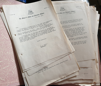
Documents, Ballarat School of Mines General Internal Adminstration, 1966-1967
Correspondence relating to the Ballarat School of Mines. ballarat school of mines, e.j. barker, jack barker, harold trudinger, prize night, fees, t.g. seymour, correspondence, graduation, ballarat civic hall, floor plan, e.a. bald, royal australian chemical institute, open night -
Federation University Historical Collection
Document - Documents, Federation University Notifications Referring to Covid-19, 2020, 06/04/2020
On 12 January, the World Health Organization (WHO) confirmed that a novel coronavirus was the cause of a respiratory illness in a cluster of people in Wuhan City, Hubei Province, China, who had initially come to the attention of the WHO on 31 December 2019. On 3 March, the Reserve Bank of Australia became the first central bank to cut interest rates in response to the outbreak. Official interest rates were cut by 0.25% (25 base points) to a record low of 0.5%. On 12 March, the Federal Government announced a A$17.6 billion stimulus package, the first since the 2008 GFC. he package consists of multiple parts, a one-off A$750 payment to around 6.5 million welfare recipients as early as 31 March 2020, small business assistance with 700,000 grants up to $25,000 and a 50% wage subsidy for 120,000 apprenticies or trainees for up to 9 months, 1 billion to support economically impacted sectors, regions and communities, and $700 million to increase tax write off and $3.2 billion to support short-term small and medium-sized business investment. On 16 March, Premier Dan Andrews and Minister for Health Jenny Mikakos declared a state of emergency for Victoria for at least four weeks. On 19 March, the Reserve Bank again cut interest rates by a further 0.25% to 0.25%, the lowest in Australian history. On 22 March, the government announced a second stimulus package of A$66bn, increasing the amount of total financial package offered to A$89bn. This included several new measures like doubling income support for individuals on Jobseeker's allowance, granting A$100,000 to small and medium-sized businesses and A$715 million to Australian airports and airlines. It also allowed individuals affected by the outbreak to access up to A$10,000 of their superannuation during 2019–2020 and also being able to take an additional same amount for the next year. on the same day Victorian Premier Daniel Andrews announced on 22 March that the state will bring the school holiday forwards to 24 March from 27 March. On 30 March, the Australian Federal Government announced a $130 billion "JobKeeper" wage subsidy program offering to pay employers up to $1500 a fortnight per full-time, part-time or casual employee that has worked for that business for over a year. For a business to be eligible, they must have lost 30% of turnover after 1 March of annual revenue up to and including $1 billion. For businesses with a revenue of over $1 billion, turnover must have decreased by 50%. Businesses are then required by law to pay the subsidy to their staff, in lieu of their usual wages. This response came after the enormous job losses seen just a week prior when an estimated 1 million Australians lost their jobs. This massive loss in jobs caused the myGov website to crash and lines out of Centrelink offices to run hundreds of metres long.The program was backdated to 1 March, to aim at reemploying the many people who had just lost their jobs in the weeks before. Businesses would receive the JobKeeper subsidy for six months. On 2 April, the number of cases in Victoria exceeded 1,000, including over 100 healthcare workers. On 5 April, New South Wales Police launched a criminal investigation into whether the operator of Ruby Princess, Carnival Australia, broke the Biosecurity Act 2015 (Cwth) and New South Wales state laws, by deliberately concealing COVID-19 cases. On 6 April, the Department of Health revealed that 2,432 people recovered from the infection as the federal government started reporting recovery statistics. This is more than a third from the official number reported so far, Deputy Chief Medical Officer Professor Paul Kelly stating, "I think it is important. Firstly it really reinforces that message, which is a true one, that most people who get this disease do recover”. The day before, at 3pm, it was announced that 2,315 of the 5,687 confirmed coronavirus cases had recovered. May 2020 - An outbreak in Victoria at a meatworks that was later revealed to be Cedar Meats was announced on 02 May with eight cases. By 8 May, the cluster of cases linked to Cedar Meats in Victoria was 71, consisting of at least 57 workers and 13 close contacts, including a nurse, aged care worker and high school student. The number had increased to 75 by 9 May, 88 by 13 May, and 90 by 14 May. On 9 May, two Victorian cases were announced to be related to McDonald's Fawkner. By 18 May, this had increased to 12 cases, and on that day it was revealed that a delivery driver had tested positive, prompting the closing for cleaning of 12 more McDonald's locations: Melton East, Laverton North, Yallambie, Taylors Lakes, Campbellfield, Sunbury, Hoppers Crossing, Riverdale Village, Sandown, Calder Highway Northbound/Outbound, Calder Highway Southbound/Inbound, and BP Rockbank Service Centre Outbound. On 15 May, South Australia became the second jurisdiction, after the ACT, to be free of any active cases, however on 26 May, a woman returning from overseas who was granted exemption into South Australia from her hotel quarantine in Victoria tested positive for COVID-19. This was the first new case in 19 days for the state.[101] On 4 June, it was announced that the woman had recovered and the state was free of any active cases once again.[102] On 17 May, Victoria announced two further business sites had been shut down due to a suspected case at each. Domino's Pizza in Fairfield has been shut for two weeks, and mattress manufacturer The Comfort Group in Deer Park was closed from Friday 15 May to at least Wednesday 20 May. On 6 June, both New South Wales and Victoria reported no new cases for the previous 24 hours, with only Queensland and Western Australia reporting one new case each, the lowest national total since February. Western Australia also announced two old cases. However, the new case in Queensland was linked to the Rydges on Swanston cluster in Melbourne when a man who travelled from Melbourne to Brisbane on Virgin flight VA313 on 1 June tested positive.Notifications to staff and students relating to the worldwide Covid-19 Pandemic. * Federation University COVIDSafe Plan prepared by the Transition to Campus Control Group, Version 1.4, 21 July 2020 * Federation University Notifications Referring to Covid-19, 18 August 2020covid-19, corona virus, pandemic, social distancing, lock down, federation university australia, covidsafe plan -
Federation University Historical Collection
Document - Document - Letter, Ballarat Junior Technical School: Letter from The Metropolitan Technical Men's Branch of the V.T.U. re class sizes, 1952
Letter from the Secretary of the Metropolitan Technical Men's Branch of the Victorian Teachers' Union, Findlay Masson, outlining the problem of class sizes in Technical Schools. Classes of 48 students are regular in English, Mathematics and Social Studies. In practical classes the size has been set. Asking Technical Schools to submit details of extra accommodation required to allow for reduction of class size to 40 students or less. These needs to be incorporated into a proposed plan to be submitted to the Education Department through the V.T.U. Cream sheet of paper, typed Headmaster Ballarat Junior hand written in red pen Answered 23/10 in pencil Signature of Findlay C Masson, Secretary in red penballarat junior technical school, headmaster, l garner, victorian teachers' union, v.t.u., findlay masson, secretary, metropolitan technical men's branch, class sizes, reduction in number, extra accommodation, proposed plan, education department -
Federation University Historical Collection
Document, Part of a report into disaster planning
... of a report into disaster planning Document ... -
Federation University Historical Collection
Document - Document - Letter, Ballarat Junior Technical School: Letter to Mrs O'Dell re Scholarship recipients for 1952
Letter to Mrs O'Dell, Honorary Secretary Mothers' Club, with a receipt for Six Pounds for their scholarships for 1952. Information on past students who had scholarships given. Colin Hocking - gained Intermediate Technical Certificate at Diploma entrance level, now in an architect's office. Kevin Parkinson passed his Junior Technical Certificate. Norman Leckie plans to complete Form 4 and ultimately become a teacher.Cream pages, typed ballarat junior technical school, head master, l garner, mrs o'dell, hon secretary, mothers' club, scholarship money, colin hocking, intermediate technical certificate, diploma entrance level, architect's office, kevin parkinson, junior technical certificate, norman leckie, form 4, teacher -
Federation University Historical Collection
Document - Document - Letter, Ballarat Junior Technical School: Letter to the Education Department re Suggested alterations to School Entrance, 1952
Letter to the Education Department thanking them for additional desks and lockers. Wishes to put forward for consideration a proposal to improve the entrance to the building. Present entrance inadequate and opens on to a cloak room and wash basins. Parents are expected to wait in the area. Plan show suggested changes and carried out at small cost and greatly enhance the appearance and prestige of the school.2 Cream pages, typed ballarat junior technical school, head master, l garner, education department, acknowledge receiving new desks and lockers, changes to entrance needed, wash basins, lockers coat pegs, accommodation for parents inadequate, plans, enhance building -
Federation University Historical Collection
Document, Ballarat Junior Technical School Building
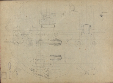
The Ballarat Junior Technical School, a division of the Ballarat School of Mines, was established in 1913 and moved into a new, custom built building in 1921.Four photographs of the newly completed Ballarat Junior Technical School. .1) Drawing of a plan for a building on the Ballarat Gaol site in 1947 .2) Newspaper photographs of entrance to the Ballarat Junior Technical School .3 & .4) Plans for the Ballarat Junior Technical School on the Gaol Reserve drawn by George Crawley in 1934. ballarat junior technical school -
 Federation University Historical Collection
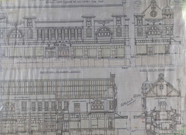
Plan - Architectural Plans, Australian Natives' Association Ballarat Branch No 4 Architectural Plans
Percy Richards taught Architecture and Building Construction at The Ballarat Art School - a division of Ballarat School of Mines from 1918-1921. He was responsible for the design of a number of buildings in the district. This item is the "Specification of work required to be done and materiaals required for construction of the new A.N.A. Building at the corner of Sturt, Albert and Lewis Streets, Ballarat. Prepared by and to the satisfaction of P.S. Richards, A.R.V.I.A. Architect and subject to the General Conditions of Contract." "BALLARAT CITY A.N.A. BALLARAT, Wednesday — The Ballarat City branch, A.N.A., which was formed nearly 50 years ago, ranks fourth on the association records, but several of the members were prominent in establishing the association in Melbourne a year or two earlier. On the past half-year's operations the total funds increased by £1558/18/3 to £29.389/11/11. The membership now totals 949. The committee recommended that as the property at the corner of Sturt and Albert Streets, which had been intended as the site of a new hall, had been sold, steps should he taken to remodel the present hall, and bring It up to date. The report was adopted." (The Herald, 18 June 1924)Fourteen detailed drawings showing the specifications for each section of the new A.N.A. building for Ballarat. A 24 page document submitted to the Public Health Department, Victoria, received 15 January 1918 and a 3 page document related to Reinforced Concrete Particulars. All contained in a labelled black metal cylinder.A.N.A.4. PLANS painted on side and lid. Signature of P.S. Richards.ana, australian natives' association, architecture, percy richards, building specifications, ballarat, technical art school ballarat, materials, construction, p.s. richards, percival selwyn richards -
Federation University Historical Collection
Document - Reference, Correspondence between Herbert H. Smith and E.J. Tippett, 1911
H. H. Herbert was the Principal of the Ballarat Technical Art School.Handwritten correspondenceDear Mr Tippett Re Your Suggestions that I supply you with a record of the history of the Art School. To be placed on record which I think is very desirable & as I am the ony living man that can do so, I will be very please to do so now, before I get into my dotage. I was one of the first students - when it was established by the Art-Gallery & was for 7 years the first and only assistant master - under Mr Carew-Smyth leaving for 5 years to take charge of the Sale Techl Art School for 5 years to take charge of Art School Ballarat, until my retirement in 1940. I think the history of the School will be a valuable & interesting record. I was responsible for getting the present building & the plan initiated by me was adopted and carried out by Col Watson of the Public Works Dept. My approach through the Ladies Art Assn to Sir Alexander Peacock resulted in him placing 80,000 on the estimates for the building of same. ...kalgoorlie school of mines reference, kalgoorlie school of mines, a.f. heseltine, f.b. allen, herbert h. smith, h. h. smith, ballarat technical art school -
Federation University Historical Collection
Document, Federation University Coronavirus - Advice for staff and students, 17/05/2021
On 12 January, the World Health Organization (WHO) confirmed that a novel coronavirus was the cause of a respiratory illness in a cluster of people in Wuhan City, Hubei Province, China, who had initially come to the attention of the WHO on 31 December 2019. On 3 March, the Reserve Bank of Australia became the first central bank to cut interest rates in response to the outbreak. Official interest rates were cut by 0.25% (25 base points) to a record low of 0.5%. On 12 March, the Federal Government announced a A$17.6 billion stimulus package, the first since the 2008 GFC. he package consists of multiple parts, a one-off A$750 payment to around 6.5 million welfare recipients as early as 31 March 2020, small business assistance with 700,000 grants up to $25,000 and a 50% wage subsidy for 120,000 apprenticies or trainees for up to 9 months, 1 billion to support economically impacted sectors, regions and communities, and $700 million to increase tax write off and $3.2 billion to support short-term small and medium-sized business investment. On 16 March, Premier Dan Andrews and Minister for Health Jenny Mikakos declared a state of emergency for Victoria for at least four weeks. On 19 March, the Reserve Bank again cut interest rates by a further 0.25% to 0.25%, the lowest in Australian history. On 22 March, the government announced a second stimulus package of A$66bn, increasing the amount of total financial package offered to A$89bn. This included several new measures like doubling income support for individuals on Jobseeker's allowance, granting A$100,000 to small and medium-sized businesses and A$715 million to Australian airports and airlines. It also allowed individuals affected by the outbreak to access up to A$10,000 of their superannuation during 2019–2020 and also being able to take an additional same amount for the next year. on the same day Victorian Premier Daniel Andrews announced on 22 March that the state will bring the school holiday forwards to 24 March from 27 March. On 30 March, the Australian Federal Government announced a $130 billion "JobKeeper" wage subsidy program offering to pay employers up to $1500 a fortnight per full-time, part-time or casual employee that has worked for that business for over a year. For a business to be eligible, they must have lost 30% of turnover after 1 March of annual revenue up to and including $1 billion. For businesses with a revenue of over $1 billion, turnover must have decreased by 50%. Businesses are then required by law to pay the subsidy to their staff, in lieu of their usual wages. This response came after the enormous job losses seen just a week prior when an estimated 1 million Australians lost their jobs. This massive loss in jobs caused the myGov website to crash and lines out of Centrelink offices to run hundreds of metres long.The program was backdated to 1 March, to aim at reemploying the many people who had just lost their jobs in the weeks before. Businesses would receive the JobKeeper subsidy for six months. On 2 April, the number of cases in Victoria exceeded 1,000, including over 100 healthcare workers. On 5 April, New South Wales Police launched a criminal investigation into whether the operator of Ruby Princess, Carnival Australia, broke the Biosecurity Act 2015 (Cwth) and New South Wales state laws, by deliberately concealing COVID-19 cases. On 6 April, the Department of Health revealed that 2,432 people recovered from the infection as the federal government started reporting recovery statistics. This is more than a third from the official number reported so far, Deputy Chief Medical Officer Professor Paul Kelly stating, "I think it is important. Firstly it really reinforces that message, which is a true one, that most people who get this disease do recover”. The day before, at 3pm, it was announced that 2,315 of the 5,687 confirmed coronavirus cases had recovered. May 2020 - An outbreak in Victoria at a meatworks that was later revealed to be Cedar Meats was announced on 02 May with eight cases. By 8 May, the cluster of cases linked to Cedar Meats in Victoria was 71, consisting of at least 57 workers and 13 close contacts, including a nurse, aged care worker and high school student. The number had increased to 75 by 9 May, 88 by 13 May, and 90 by 14 May. On 9 May, two Victorian cases were announced to be related to McDonald's Fawkner. By 18 May, this had increased to 12 cases, and on that day it was revealed that a delivery driver had tested positive, prompting the closing for cleaning of 12 more McDonald's locations: Melton East, Laverton North, Yallambie, Taylors Lakes, Campbellfield, Sunbury, Hoppers Crossing, Riverdale Village, Sandown, Calder Highway Northbound/Outbound, Calder Highway Southbound/Inbound, and BP Rockbank Service Centre Outbound. On 15 May, South Australia became the second jurisdiction, after the ACT, to be free of any active cases, however on 26 May, a woman returning from overseas who was granted exemption into South Australia from her hotel quarantine in Victoria tested positive for COVID-19. This was the first new case in 19 days for the state.[101] On 4 June, it was announced that the woman had recovered and the state was free of any active cases once again.[102] On 17 May, Victoria announced two further business sites had been shut down due to a suspected case at each. Domino's Pizza in Fairfield has been shut for two weeks, and mattress manufacturer The Comfort Group in Deer Park was closed from Friday 15 May to at least Wednesday 20 May. On 6 June, both New South Wales and Victoria reported no new cases for the previous 24 hours, with only Queensland and Western Australia reporting one new case each, the lowest national total since February. Western Australia also announced two old cases. However, the new case in Queensland was linked to the Rydges on Swanston cluster in Melbourne when a man who travelled from Melbourne to Brisbane on Virgin flight VA313 on 1 June tested positive.Printout of a webspage designed to guide staff and students through the COVID-19 pandemic. covid-19, corona virus, pandemic, federation university australia, covidsafe plan, response -
Federation University Historical Collection
Document, Federation University CovidSafe Plan, 17/05/2021
... pandemic. Federation University CovidSafe Plan Document ...On 12 January, the World Health Organization (WHO) confirmed that a novel coronavirus was the cause of a respiratory illness in a cluster of people in Wuhan City, Hubei Province, China, who had initially come to the attention of the WHO on 31 December 2019. On 3 March, the Reserve Bank of Australia became the first central bank to cut interest rates in response to the outbreak. Official interest rates were cut by 0.25% (25 base points) to a record low of 0.5%. On 12 March, the Federal Government announced a A$17.6 billion stimulus package, the first since the 2008 GFC. he package consists of multiple parts, a one-off A$750 payment to around 6.5 million welfare recipients as early as 31 March 2020, small business assistance with 700,000 grants up to $25,000 and a 50% wage subsidy for 120,000 apprenticies or trainees for up to 9 months, 1 billion to support economically impacted sectors, regions and communities, and $700 million to increase tax write off and $3.2 billion to support short-term small and medium-sized business investment. On 16 March, Premier Dan Andrews and Minister for Health Jenny Mikakos declared a state of emergency for Victoria for at least four weeks. On 19 March, the Reserve Bank again cut interest rates by a further 0.25% to 0.25%, the lowest in Australian history. On 22 March, the government announced a second stimulus package of A$66bn, increasing the amount of total financial package offered to A$89bn. This included several new measures like doubling income support for individuals on Jobseeker's allowance, granting A$100,000 to small and medium-sized businesses and A$715 million to Australian airports and airlines. It also allowed individuals affected by the outbreak to access up to A$10,000 of their superannuation during 2019–2020 and also being able to take an additional same amount for the next year. on the same day Victorian Premier Daniel Andrews announced on 22 March that the state will bring the school holiday forwards to 24 March from 27 March. On 30 March, the Australian Federal Government announced a $130 billion "JobKeeper" wage subsidy program offering to pay employers up to $1500 a fortnight per full-time, part-time or casual employee that has worked for that business for over a year. For a business to be eligible, they must have lost 30% of turnover after 1 March of annual revenue up to and including $1 billion. For businesses with a revenue of over $1 billion, turnover must have decreased by 50%. Businesses are then required by law to pay the subsidy to their staff, in lieu of their usual wages. This response came after the enormous job losses seen just a week prior when an estimated 1 million Australians lost their jobs. This massive loss in jobs caused the myGov website to crash and lines out of Centrelink offices to run hundreds of metres long.The program was backdated to 1 March, to aim at reemploying the many people who had just lost their jobs in the weeks before. Businesses would receive the JobKeeper subsidy for six months. On 2 April, the number of cases in Victoria exceeded 1,000, including over 100 healthcare workers. On 5 April, New South Wales Police launched a criminal investigation into whether the operator of Ruby Princess, Carnival Australia, broke the Biosecurity Act 2015 (Cwth) and New South Wales state laws, by deliberately concealing COVID-19 cases. On 6 April, the Department of Health revealed that 2,432 people recovered from the infection as the federal government started reporting recovery statistics. This is more than a third from the official number reported so far, Deputy Chief Medical Officer Professor Paul Kelly stating, "I think it is important. Firstly it really reinforces that message, which is a true one, that most people who get this disease do recover”. The day before, at 3pm, it was announced that 2,315 of the 5,687 confirmed coronavirus cases had recovered. May 2020 - An outbreak in Victoria at a meatworks that was later revealed to be Cedar Meats was announced on 02 May with eight cases. By 8 May, the cluster of cases linked to Cedar Meats in Victoria was 71, consisting of at least 57 workers and 13 close contacts, including a nurse, aged care worker and high school student. The number had increased to 75 by 9 May, 88 by 13 May, and 90 by 14 May. On 9 May, two Victorian cases were announced to be related to McDonald's Fawkner. By 18 May, this had increased to 12 cases, and on that day it was revealed that a delivery driver had tested positive, prompting the closing for cleaning of 12 more McDonald's locations: Melton East, Laverton North, Yallambie, Taylors Lakes, Campbellfield, Sunbury, Hoppers Crossing, Riverdale Village, Sandown, Calder Highway Northbound/Outbound, Calder Highway Southbound/Inbound, and BP Rockbank Service Centre Outbound. On 15 May, South Australia became the second jurisdiction, after the ACT, to be free of any active cases, however on 26 May, a woman returning from overseas who was granted exemption into South Australia from her hotel quarantine in Victoria tested positive for COVID-19. This was the first new case in 19 days for the state.[101] On 4 June, it was announced that the woman had recovered and the state was free of any active cases once again.[102] On 17 May, Victoria announced two further business sites had been shut down due to a suspected case at each. Domino's Pizza in Fairfield has been shut for two weeks, and mattress manufacturer The Comfort Group in Deer Park was closed from Friday 15 May to at least Wednesday 20 May. On 6 June, both New South Wales and Victoria reported no new cases for the previous 24 hours, with only Queensland and Western Australia reporting one new case each, the lowest national total since February. Western Australia also announced two old cases. However, the new case in Queensland was linked to the Rydges on Swanston cluster in Melbourne when a man who travelled from Melbourne to Brisbane on Virgin flight VA313 on 1 June tested positive.Printout of a webpage designed to guide staff and students through the COVID-19 pandemic. covid-19, corona virus, pandemic, federation university australia, covidsafe plan, response -
Federation University Historical Collection
Document, Federation University Coronavirus Updates, 2020-2021, 17/05/2021
On 12 January, the World Health Organization (WHO) confirmed that a novel coronavirus was the cause of a respiratory illness in a cluster of people in Wuhan City, Hubei Province, China, who had initially come to the attention of the WHO on 31 December 2019. On 3 March, the Reserve Bank of Australia became the first central bank to cut interest rates in response to the outbreak. Official interest rates were cut by 0.25% (25 base points) to a record low of 0.5%. On 12 March, the Federal Government announced a A$17.6 billion stimulus package, the first since the 2008 GFC. he package consists of multiple parts, a one-off A$750 payment to around 6.5 million welfare recipients as early as 31 March 2020, small business assistance with 700,000 grants up to $25,000 and a 50% wage subsidy for 120,000 apprenticies or trainees for up to 9 months, 1 billion to support economically impacted sectors, regions and communities, and $700 million to increase tax write off and $3.2 billion to support short-term small and medium-sized business investment. On 16 March, Premier Dan Andrews and Minister for Health Jenny Mikakos declared a state of emergency for Victoria for at least four weeks. On 19 March, the Reserve Bank again cut interest rates by a further 0.25% to 0.25%, the lowest in Australian history. On 22 March, the government announced a second stimulus package of A$66bn, increasing the amount of total financial package offered to A$89bn. This included several new measures like doubling income support for individuals on Jobseeker's allowance, granting A$100,000 to small and medium-sized businesses and A$715 million to Australian airports and airlines. It also allowed individuals affected by the outbreak to access up to A$10,000 of their superannuation during 2019–2020 and also being able to take an additional same amount for the next year. on the same day Victorian Premier Daniel Andrews announced on 22 March that the state will bring the school holiday forwards to 24 March from 27 March. On 30 March, the Australian Federal Government announced a $130 billion "JobKeeper" wage subsidy program offering to pay employers up to $1500 a fortnight per full-time, part-time or casual employee that has worked for that business for over a year. For a business to be eligible, they must have lost 30% of turnover after 1 March of annual revenue up to and including $1 billion. For businesses with a revenue of over $1 billion, turnover must have decreased by 50%. Businesses are then required by law to pay the subsidy to their staff, in lieu of their usual wages. This response came after the enormous job losses seen just a week prior when an estimated 1 million Australians lost their jobs. This massive loss in jobs caused the myGov website to crash and lines out of Centrelink offices to run hundreds of metres long.The program was backdated to 1 March, to aim at reemploying the many people who had just lost their jobs in the weeks before. Businesses would receive the JobKeeper subsidy for six months. On 2 April, the number of cases in Victoria exceeded 1,000, including over 100 healthcare workers. On 5 April, New South Wales Police launched a criminal investigation into whether the operator of Ruby Princess, Carnival Australia, broke the Biosecurity Act 2015 (Cwth) and New South Wales state laws, by deliberately concealing COVID-19 cases. On 6 April, the Department of Health revealed that 2,432 people recovered from the infection as the federal government started reporting recovery statistics. This is more than a third from the official number reported so far, Deputy Chief Medical Officer Professor Paul Kelly stating, "I think it is important. Firstly it really reinforces that message, which is a true one, that most people who get this disease do recover”. The day before, at 3pm, it was announced that 2,315 of the 5,687 confirmed coronavirus cases had recovered. May 2020 - An outbreak in Victoria at a meatworks that was later revealed to be Cedar Meats was announced on 02 May with eight cases. By 8 May, the cluster of cases linked to Cedar Meats in Victoria was 71, consisting of at least 57 workers and 13 close contacts, including a nurse, aged care worker and high school student. The number had increased to 75 by 9 May, 88 by 13 May, and 90 by 14 May. On 9 May, two Victorian cases were announced to be related to McDonald's Fawkner. By 18 May, this had increased to 12 cases, and on that day it was revealed that a delivery driver had tested positive, prompting the closing for cleaning of 12 more McDonald's locations: Melton East, Laverton North, Yallambie, Taylors Lakes, Campbellfield, Sunbury, Hoppers Crossing, Riverdale Village, Sandown, Calder Highway Northbound/Outbound, Calder Highway Southbound/Inbound, and BP Rockbank Service Centre Outbound. On 15 May, South Australia became the second jurisdiction, after the ACT, to be free of any active cases, however on 26 May, a woman returning from overseas who was granted exemption into South Australia from her hotel quarantine in Victoria tested positive for COVID-19. This was the first new case in 19 days for the state.[101] On 4 June, it was announced that the woman had recovered and the state was free of any active cases once again.[102] On 17 May, Victoria announced two further business sites had been shut down due to a suspected case at each. Domino's Pizza in Fairfield has been shut for two weeks, and mattress manufacturer The Comfort Group in Deer Park was closed from Friday 15 May to at least Wednesday 20 May. On 6 June, both New South Wales and Victoria reported no new cases for the previous 24 hours, with only Queensland and Western Australia reporting one new case each, the lowest national total since February. Western Australia also announced two old cases. However, the new case in Queensland was linked to the Rydges on Swanston cluster in Melbourne when a man who travelled from Melbourne to Brisbane on Virgin flight VA313 on 1 June tested positive.Printout of a number of regular Coronavirus updates that were distributed during the Covid-19 Pandemic. covid-19, corona virus, pandemic, federation university australia, covidsafe plan, response, face masks, blended workfore, lock down, office capacity, gatherings, physical distancing, social distancing, cotact tracing, exams, safe start on campus, transition to campus, employee assistance program -
Federation University Historical Collection
Document, Allum Lovell, Former Ballarat Brewery Conservation Analsysis, c1990
Carlton and United Breweries purchased the Ballarat Brewering Company Limited site in 1958, including its chain of 114 hotels. In the mid 1980s CUB transferred the production of Blalarat Bertie to the Abbotsford plants and started producing Guimes under license in the Ballarat plant. On 30 June 1989 CUB closed the Ballarat site.Report conducted by Allum Lovell for the Ballarat School of Mines. former ballarat brewery, conservation management plan, james coglan, william kenna, tulluch and mclaren, phoenix brewery, chimney, brew tower, cooling tower, carlton and united breweries, brewery building -
 Bendigo Military Museum
Map - PLAN, FRAMED
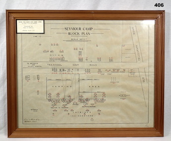
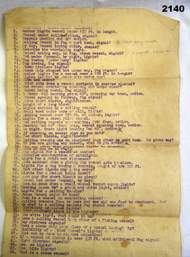
... and 2nd AIF. Refer 2039 for Service History also 2034P. documents ...LT COL BENJAMIN THOMAS ROY CHADD No's 10594, VX20311, 1st and 2nd AIF. Refer 2039 for Service History also 2034P. Plan, detailing Seymour Camp Block Plan, Signals 7th Aust Div Camp 1940, re LT COL BENJAMIN THOMAS ROY CHADD. Tan coloured frame, glass front, cardboard backing, detail of camp layout, scale 160' = 1".documents - maps/plans, military history - army, frames -
 Bendigo Military Museum
Newspaper - NEWSPAPER, ARGUS, Melbourne Argus, C. June 1942
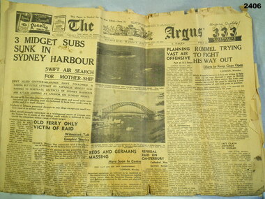
The Argus, Melbourne Tuesday June 2 1942. 6 pages. Main headlines: - 3 midget subs sunk in Sydney Harbour - Rommel trying to fight his way out - No more beer for Germany - Planning vase air offensivedocuments - newspapers, military history, the argus -
 Bendigo Military Museum
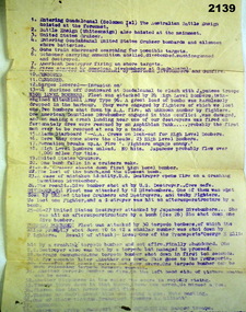
Administrative record - DOCUMENT, NAVAL, Est late 1942
... Hobart. Refer 2134 for service history also 2137, 2147. Documents ...Item belonged to Arthur George Holley No 13556 RAN, HMAS Hobart. Refer 2134 for service history also 2137, 2147. Typed sheet in purple listing points 1-41 re brief description of the retaking of Gaudalcanal in 1942. There are 3 underlined headings, "High level bombers, Dive bombers, Torpedoe bombers". HMAS Hobart and Australia were involved. documents, naval, plans -
 Bendigo Military Museum
Accessory - DOCUMENT, NAVAL
... . Naval plans documents Typed sheet in purple ink with points ...Item belonged to Arthur George Holley No 13556 RAN, HMAS Hobart. Refer 2134 for service history also 2135.3, 2137, 2147. Typed sheet in purple ink with points numbered from 1-66 re basically questions on Naval actions covering a range of subjects. naval, plans, documents -
 Bendigo Military Museum
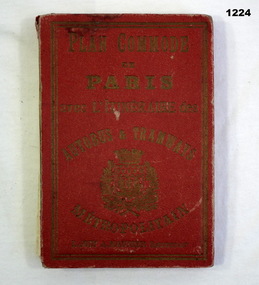
Plan - MAP, TOURIST, L Joly, A Maunier, WWI
... . Refer 1317P, 1320P. documents-maps french "Plan commode de Paris ...The map belonged to Jack Grinton No 1043 38th Batt AIF. At Wars end extensive leave was granted, Jack journeyed to Paris, Nice, Monte Carlo taking many photos. Part of the Grinton collection which included hundreds of negatives and developed photos that he took during the War. Refer Cat No 1280 for service details. Refer 1317P, 1320P.Map of Paris. Red cardboard or paper hardcover, new edition guide of metropolitan Paris (ministries, tramways, monuments), Index in front, folded paper map attached to back cover. "Plan commode de Paris avec l'itineraire des autobus & tramways metropolitan"documents-maps, french