Showing 821 items matching "plenty river"
-
 Greensborough Historical Society
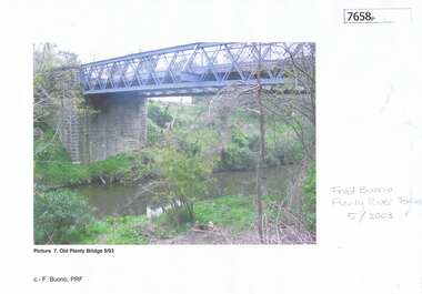
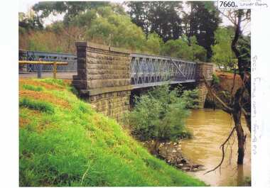
Photograph - Photograph (Copy), Anne Paul, Old Plenty Bridge Lower Plenty, 2003_05
... plenty river bridge..., now Edward Willis Drive, including the old Plenty River Bridge.... the old Plenty River Bridge. lower plenty main road lower plenty ...Various views of entry into Lot 2A Main Road Lower Plenty, now Edward Willis Drive, including the old Plenty River Bridge.3 colour photographs printed on paper, handwritten or typed captionslower plenty, main road lower plenty, edward willis drive lower plenty, plenty river bridge, plenty river forum -
 Greensborough Historical Society
Photograph - Digital Image, Marilyn Smith, Willinda Park bridge to George Court, 06/11/2017
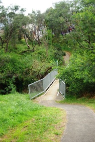
... plenty river... River. This photograph shows the footbridge across the Plenty... and is adjacent to the Plenty River. This photograph shows the footbridge ...Willinda Park is situated in Beatrix Street Greensborough. It has an athletics track and field and is adjacent to the Plenty River. This photograph shows the footbridge across the Plenty River to George Court.Digital copy of colour photographwillinda park, beatrix street greensborough, athletics, plenty river -
 Greensborough Historical Society
Photograph - Digital Image, Marilyn Smith, Willinda Park bridge to Simms Road, 06/11/2017
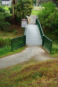
... plenty river... River. This photograph shows the footbridge across the Plenty... and is adjacent to the Plenty River. This photograph shows the footbridge ...Willinda Park is situated in Beatrix Street Greensborough. It has an athletics track and field and is adjacent to the Plenty River. This photograph shows the footbridge across the Plenty River to Simms Road Reserve.Digital copy of colour photographwillinda park, beatrix street greensborough, athletics, plenty river -
 Greensborough Historical Society
Aerial Photograph - Digital Image, Greensborough central with modern landmarks, 2015_
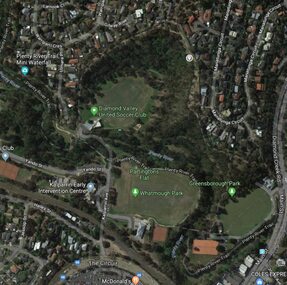
... plenty river... and businesses, including Partington's Flat, Whatmough Park, Plenty River... Flat, Whatmough Park, Plenty River Trail. Bounded by Diamond ...Aerial photograph of Greensborough showing modern landmarks and businesses, including Partington's Flat, Whatmough Park, Plenty River Trail. Bounded by Diamond Creek Road to the East and the Plenty River to the East, The Circuit to the South. Aerial photograph in colour with overlay text indicating modern landmarksgreensborough, manatunga circuit greensborough, plenty river, diamond creek road greensborough, the circuit greensborough, aerial photograph -
 Greensborough Historical Society
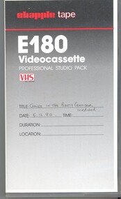
Film - Video Cassette, John Ramsdale, Change in the Plenty corridor, 05/12/1990
... plenty river... in 1990, investigating changes along the Plenty River.... the Plenty River. Part of the John Ramsdale collection of slides ...Video of a fieldwork for teachers, taken by John Ramsdale in 1990, investigating changes along the Plenty River.Part of the John Ramsdale collection of slides and audio visual material.VHS video tape, 2 copies."Chapple E180 videocassette" and "Change in the Plenty corridor unedited 5.12.90"plenty river, plenty gorge -
 Eltham District Historical Society Inc
Negative - Photograph, J.A. McDonald, Eltham-Yarra Glen Road, Lower Plenty footbridge, Sep. 1955
... Plenty River Trail... at the Shire of Eltham boundary at the Plenty River. West of the river... at the Shire of Eltham boundary at the Plenty River. West of the river ...The Eltham-Yarra Glen Road as designated originated at the Shire of Eltham boundary at the Plenty River. West of the river the road was known as the Heidelberg-Eltham Road. The section from the Plenty River is now known as Lower Plenty Road which becomes Main Road. The footbridge no longer exists but was originally sited to the south, adjacent to the old Lower Plenty Bridge, now part of the Plenty River Trail. Record of various Shire of Eltham infrastructure works undertaken during the period of 1952-1962 involving bridge and road reconstruction projects, sometimes with Eltham Shire Council Project Reference numbers quoted. It was during this period that a number of significant improvements were made to roads and new bridges constructed within the shire that remain in place as of present day (2022). In many situations, the photos provide a tangible visible record of infrastructure that existed throughout the early days of the Shire. The album was put together by or under the direction of the Shire Engineer, J.A. McDonald.1955-09, eltham-yarra glen road, lower plenty footbridge, lower plenty, lower plenty bridge, lower plenty road, main road, plenty river trail, bridge construction, infrastructure, shire of eltham -
 Greensborough Historical Society
Photograph - Digital Image, River's up on Greensborough Bridge, 1910c
... plenty river...Plenty River in flood at old Greensborough bridge.... Plenty Lower Plenty melbourne Plenty River in flood at old ...Plenty River in flood at old Greensborough bridge.Digital copy of black and white photograph.plenty river, floods -
 Eltham District Historical Society Inc
Negative - Photograph, J.A. McDonald, Eltham-Yarra Glen Road, Lower Plenty footbridge, Sep. 1955
... Plenty River Trail...-Eltham Road. The section from the Plenty River is now known...-Eltham Road. The section from the Plenty River is now known ...Tony Carberry and J. Jolly The Eltham-Yarra Glen Road as designated originated at the Shire of Eltham boundary at the Plenty River. West of the river the road was known as the Heidelberg-Eltham Road. The section from the Plenty River is now known as Lower Plenty Road which becomes Main Road. The footbridge no longer exists but was originally sited to the south, adjacent to the old Lower Plenty Bridge, now part of the Plenty River Trail. Record of various Shire of Eltham infrastructure works undertaken during the period of 1952-1962 involving bridge and road reconstruction projects, sometimes with Eltham Shire Council Project Reference numbers quoted. It was during this period that a number of significant improvements were made to roads and new bridges constructed within the shire that remain in place as of present day (2022). In many situations, the photos provide a tangible visible record of infrastructure that existed throughout the early days of the Shire. The album was put together by or under the direction of the Shire Engineer, J.A. McDonald.1955-09, eltham-yarra glen road, lower plenty footbridge, j. jolly, lower plenty, lower plenty bridge, lower plenty road, main road, plenty river trail, tony carberry, bridge construction, infrastructure, shire of eltham -
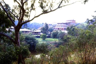
![Photograph - Digital image, Pioneer Children's Cemetery [from above], 1985_](/media/collectors/4f729f5697f83e03086015b8/items/54bb56202162f10ca8d79013/item-media/54bb56452162f10ca8d79127/item-fit-380x285.jpg) Greensborough Historical Society
Greensborough Historical SocietyPhotograph - Digital image, Pioneer Children's Cemetery [from above], 1985_
... plenty river... pioneer families lie in a private cemetery on the Plenty River... on the Plenty River. Burials occurred between 1848 and 1860 ...The unmarked graves of the children of two Greensborough pioneer families lie in a private cemetery on the Plenty River. Burials occurred between 1848 and 1860. This photograph is taken from above the cemetery site looking towards the Plenty River with the Maroondah Aqueduct in the background.An important historical site in Greensborough.Digital copy of colour photograph.pioneer childrens cemetery, plenty river, maroondah aqueduct, partington, whatmough -
 Greensborough Historical Society
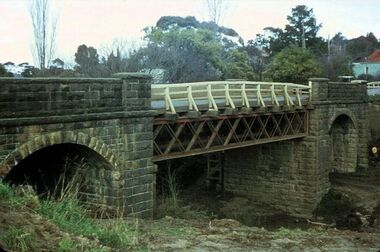
Photograph - Photograph - Digital Image, Bluestone bridge Greensborough 1960s, 1960s
... plenty river greensborough...A photograph of the bluestone bridge over the Plenty River... bridge over the Plenty River at Greensborough 1960s. bluestone ...A photograph of the bluestone bridge over the Plenty River at Greensborough 1960s.Digital copy of colour photograph. Second photo is cropped copy.bluestone bridge greensborough, plenty river greensborough, main street greensborough -
 Greensborough Historical Society
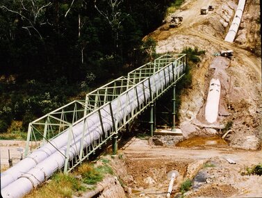
Photograph - Digital image, New pipeline replacing Watts Reservoir aqueduct, 1977_
... plenty river...Photograph of new aqueduct pipe near Plenty River... near Plenty River Greensborough. aqueduct maroondah aqueduct ...Photograph of new aqueduct pipe near Plenty River Greensborough.Digital copy of colour photograph.aqueduct, maroondah aqueduct, plenty river -
 Greensborough Historical Society
Photograph - Digital Image, Pipes over Plenty, construction of original bridge for Watts Reservoir aqueduct, 1950-1970
... plenty river...Photograph of the Maroondah aqueduct bridge over the Plenty... aqueduct bridge over the Plenty River in Greensborough. maroondah ...Photograph of the Maroondah aqueduct bridge over the Plenty River in Greensborough.Digital copy of black and white photograph.maroondah aqueduct, aqueduct, plenty river -
 Greensborough Historical Society
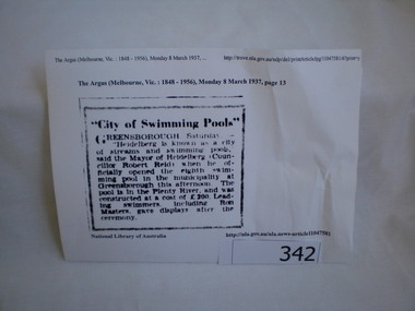
Newspaper clipping, City of swimming pools, 08/03/1937
... plenty river... in the Plenty River 1937.... of the Greensborough swimming pool in the Plenty River 1937. This pool ...A report on the opening of the Greensborough swimming pool in the Plenty River 1937.This pool on the Plenty River still exists today.Article downloaded from Trove (National Library of Australia).greensborough, swimming pools, plenty river, heidelberg city council -
 Greensborough Historical Society
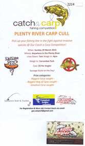
Advertising Poster, Aussie Angler, Catch a carp fishing competition, 29/03/2015
... plenty river...Flyer advertising the Plenty River carp cull March 2015... Plenty Lower Plenty melbourne Flyer advertising the Plenty River ...Flyer advertising the Plenty River carp cull March 2015Colour advertisement. Attached is business card.aussie angler, plenty river -
 Greensborough Historical Society
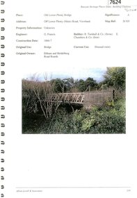
Document - Document Collection, Allom Lovell & Associates, Old Lower Plenty Bridge, 2001
... plenty river...-opening of the bridge as a link in the Plenty River Trail.... on the re-opening of the bridge as a link in the Plenty River Trail ...Heritage citation for the Old Lower Plenty Bridge, copied from Banyule Heritage Places Study; a short history of the bridge and a news clipping, dated 2001 reporting on the re-opening of the bridge as a link in the Plenty River Trail.4 p., illus. Heritage citation, 2p.; history of bridge, 1p.; newspaper clipping, 1p. plenty river, plenty river trail, old lower plenty bridge, lower plenty -
 Greensborough Historical Society
Photograph - Photograph (Copy), Anne Paul, Old bridge, Lower Plenty 2003, 2003_12
... plenty river...Two views of the old bridge over the Plenty River in Lower... the Plenty River in Lower Plenty. lower plenty plenty river floods ...Two views of the old bridge over the Plenty River in Lower Plenty.2 colour photographs printed on paper, handwritten captionslower plenty, plenty river, floods, edward willis drive lower plenty -
 Greensborough Historical Society
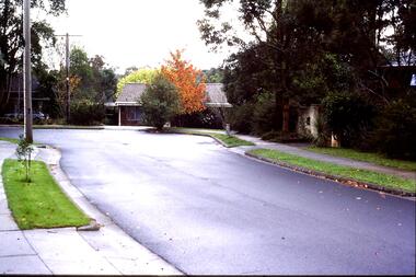
Slide - Photograph, John Ramsdale, Lower Plenty houses: Slide 79, 1990s
... plenty river... - the Plenty River is behind.... street in Lower Plenty - the Plenty River is behind. Part ...Photograph shows a residential street in Lower Plenty - the Plenty River is behind.Part of the John Ramsdale collection of slides and audio visual material.Colour photograph scanned from slide.No caption. Printed maker's mark on slide "Kodak Kodachrome Slide"lower plenty, plenty river, residential development -
 Greensborough Historical Society
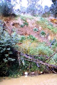
Slide - Photograph, John Ramsdale, Poor riverbank management: Slide 62, 1990s
... plenty river... of the Plenty River.... management along the banks of the Plenty River. Part of the John ...Photograph shows poor riverbank management along the banks of the Plenty River.Part of the John Ramsdale collection of slides and audio visual material.Colour photograph scanned from slide.No maker's marks. No caption on slide.plenty river -
 Greensborough Historical Society
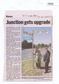
Newspaper Clipping, Junction gets upgrade, 19/12/2007
... plenty river drive greensborough...Article on the upgrade of the Diamond Creek Road and Plenty... of the Diamond Creek Road and Plenty River Drive intersection. plenty ...Article on the upgrade of the Diamond Creek Road and Plenty River Drive intersection. Black and white text, colour imageplenty river drive greensborough, diamond creek road greensborough -
 Greensborough Historical Society
Photograph - Digital image, Marilyn Smith, Partington's Flat, 16/08/2015
... plenty river trail...Partington's Flat. These photos show the Plenty River Trail... show the Plenty River Trail at Partington's Flat. partingtons ...Partington's Flat. These photos show the Plenty River Trail at Partington's Flat.Digital copy of colour photographspartingtons flat, plenty river trail -
 Greensborough Historical Society
Photograph - Digital image, Marilyn Smith, Partington's Flat: River crossing / floodway, 16/08/2015
... plenty river... crossing over the Plenty River.... the floodway / river crossing over the Plenty River. partingtons flat ...Partington's Flat. This photo shows the floodway / river crossing over the Plenty River.Digital copy of colour photographpartingtons flat, plenty river -
 Greensborough Historical Society
Report, Examining Draughtsman's Report - Watts River Aqueduct, 20/07/1897
... plenty river... north of Greensborough at its crossing point on the Plenty River... on the Plenty River. It incorporated the use of wrought iron water pipes ...This Field Survey was commissioned by the Melbourne Board of Works and was used to position the Maroondah Aqueduct bridge north of Greensborough at its crossing point on the Plenty River. It incorporated the use of wrought iron water pipes and therefore is of lighter construction than other similar bridges in the district. It features a traverse of the Plenty RiverThe Maroondah Aqueduct bridge is a significant example of late 19th century engineering. A 4 page reproduction of an Office of Titles document. Copy of handwritten report includes maps.maroondah aqueduct, watts river aqueduct, bridge, greensborough, office of titles, 1897, wrought iron water pipes, plenty river, melbourne board of works -
 Greensborough Historical Society
Photograph - Photograph (Copy), Anne Paul, Water Watch under old bridge, Lower Plenty 1990s, 1990s
... plenty river... the Plenty River in Lower Plenty.... around the bridge over the Plenty River in Lower Plenty. lower ...Two views of "Waterwatch" working around the bridge over the Plenty River in Lower Plenty.2 colour photographs printed on paper, handwritten captionslower plenty, plenty river, waterwatch -
 Greensborough Historical Society
Article - Newspaper Clipping (copy), John Harrison, Original correspondence to the Editor, by John Harrison, 09/05/1842
... plenty river... of bushrangers raiding station on the Plenty River... River bushrangers plenty river 2 p. typescript copied from Port ...Correction of a report made about the killing and capture of bushrangers raiding station on the Plenty River2 p. typescript copied from Port Phillip Patriot and Melbourne Advertiser 9 May 1842bushrangers, plenty river -
 Greensborough Historical Society
Slide - Photograph, John Ramsdale, Encroaching suburbia: Slide 10, 1990s
... plenty river... undeveloped to developed side of Plenty River.... residential looking from undeveloped to developed side of Plenty River ...Photograph shows encroaching residential looking from undeveloped to developed side of Plenty River.Part of the John Ramsdale collection of slides and audio visual material.Colour photograph scanned from slide.No maker's marks. No caption on slide.plenty river, residential development, urbanisation -
 Greensborough Historical Society
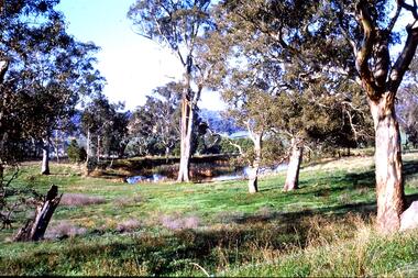
Slide - Photograph, John Ramsdale, Farmland Yallambie: Slide 49, 1990s
... plenty river...; this is near Yallambie on the Plenty River.... with gum trees and dam; this is near Yallambie on the Plenty River ...Photograph shows a rural landscape with gum trees and dam; this is near Yallambie on the Plenty River.Part of the John Ramsdale collection of slides and audio visual material.Colour photograph scanned from slide.No maker's marks. No caption on slide.plenty river, yallambie -
 Greensborough Historical Society
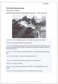
Article and Photograph, Main Street Bluestone bridge, 2017_
... plenty river... the Plenty River in Main Street Greensborough... the bluestone bridge over the Plenty River in Main Street Greensborough ...Information and photos about the bluestone bridge over the Plenty River in Main Street GreensboroughThis photograph and text was copied from a Facebook site. Members are people who lived in the Greensborough area and share their reminiscences of the area with others. The site is administered by a GHS member but is not officially affiliated with the Society. Any information is the opinion of the contributor. Article and photograph sourced from social media.bluestone bridge greensborough, plenty river, main street greensborough -
 Greensborough Historical Society
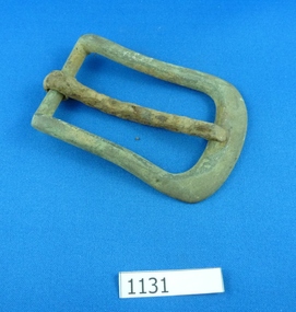
Buckle, 1880c
... plenty river...Metal buckle, possibly for horse gear. Found along Plenty... gear. Found along Plenty River near Yallambie. buckles horse ...Metal buckle, possibly for horse gear. Found along Plenty River near Yallambie.Metal buckle, some rust.buckles, horse buckles, plenty river, yallambie -
 Eltham District Historical Society Inc
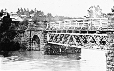
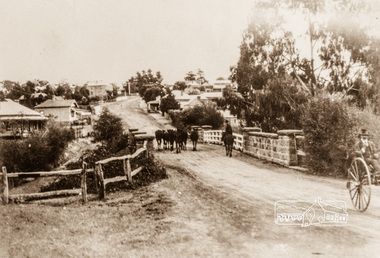
Photograph, Main Street, Greensborough, c.1900, 1900c
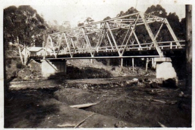
... plenty river bridge... the Plenty River Bridge... the Plenty River Bridge greensborough main street plenty river bridge ...Shows view looking up Main Street, Greensborough across the Plenty River BridgePhotograph copy originally located in a magnetic style album titled 'Greensborough Bypass 1990s 5' suffering significant degradation. No information contained in album or on reverse of photos except where noted. Relocated to archival photosafe storage.greensborough, main street, plenty river bridge -
 Greensborough Historical Society
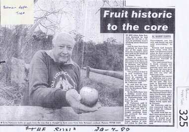
Newspaper clipping, Fruit historic to the core, 29/07/1988
... plenty river... of the "Batman" apple tree on the banks of the Plenty River.... of the Plenty River. batman apple tree greensborough kevin patterson ...Local historian Kevin Patterson discusses the origins of the "Batman" apple tree on the banks of the Plenty River.Photocopy of news clipping from "The Sun" 29/7/1988Handwritten in black pen "The Sun" 29/7/1988.batman apple tree, greensborough, kevin patterson, frederick flintoff, plenty river