Showing 4267 items matching "railway stations"
-
 Whitehorse Historical Society Inc.
Document, Stationmasters at Mitcham, n.d
... Mitcham Railway Station... Railway Station.... Mitcham melbourne Railways Mitcham Railway Station Bowman George ...List of stationmaster's between 1898 and 1934 at Mitcham Railway Station.List of stationmaster's between 1898 and 1934 at Mitcham Railway Station.List of stationmaster's between 1898 and 1934 at Mitcham Railway Station.railways, mitcham railway station, bowman, george, fraser, william, mclean, john francis., koster, j.h., mitchell, stewart, fricker, r.e., kelly, c, pascoe, w.c., whitelaw, c, hutchinson, tom, johnson, h (mrs) -
Whitehorse Historical Society Inc.
Pamphlet, Springvale Road Rail Separation project, 2009
... Nunawading Railway Station... and Nunawading railway station.... Separation Project Nunawading Railway Station Springvale Road Rail ...Overview and concept plans for the rail separation and Nunawading railway station.Overview and concept plans for the rail separation and Nunawading railway station.Overview and concept plans for the rail separation and Nunawading railway station.springvale road nunawading, springvale road rail separation project, nunawading railway station, springvale road rail alliance -
 Whitehorse Historical Society Inc.
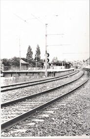
Photograph, Blackburn Railway Station, 1984
... Blackburn Railway Station...Blackburn Railway Station...Laser Print of black and white photo of Blackburn Railway... at Blackburn Lake. Meagher Dorothy Blackburn Railway Station Laser ...Donor developed Educational Programme at Blackburn Lake.Laser Print of black and white photo of Blackburn Railway Station.meagher, dorothy, blackburn railway station -
 Whitehorse Historical Society Inc.
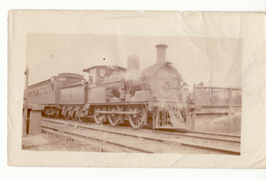
Photograph, Steam Engine at Mitcham Railway Station, C.1917
... Steam Engine at Mitcham Railway Station...mitcham railway station...Black and white photo of Steam Engine at Mitcham Railway... Mitcham melbourne mitcham railway station Black and white photo ...Black and white photo of Steam Engine at Mitcham Railway Station.mitcham railway station -
 Whitehorse Historical Society Inc.
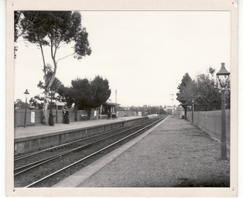
Photograph, Blackburn Railway Station, 6/01/2001 12:00:00 AM
... Blackburn Railway Station...blackburn railway station....Black and white photograph of Blackburn Railway Station... Mitcham melbourne blackburn railway station. Black and white ...Black and white photograph of Blackburn Railway Station looking west.blackburn railway station. -
 Whitehorse Historical Society Inc.
Article, Public Loo Finally Opens, 2018
... blackburn railway station...A Disabled Toilet at Blackburn Railway Station is finally... crossing removal authority blackburn railway station A Disabled ...A Disabled Toilet at Blackburn Railway Station is finally open for use.public utilities, toilet block, disabled, level crossing removal authority, blackburn railway station -
 Whitehorse Historical Society Inc.
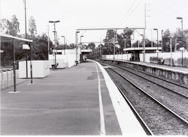
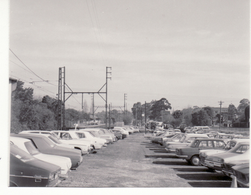
Photograph, Blackburn Railway Station, 2/08/1979 12:00:00 AM
... Blackburn Railway Station...blackburn railway station...Black and white photo of Blackburn Railway Station looking... Mitcham melbourne blackburn railway station Station Carpark Black ...Black and white photo of Blackburn Railway Station looking westblackburn railway station, station carpark -
 Whitehorse Historical Society Inc.
Photograph, Blackburn Railway Station circa 1918, C.1918
... Blackburn Railway Station circa 1918....blackburn railway station...2 copies of black and white photo of Blackburn Railway... Mitcham melbourne blackburn railway station Blackburn 2 copies ...2 copies of black and white photo of Blackburn Railway Stationblackburn railway station, blackburn -
 Ballarat Heritage Services
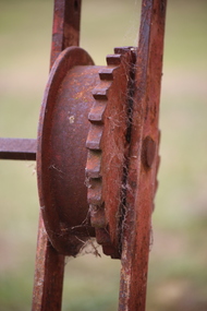
Photograph - Digital photographs, L.J. Gervasoni, Koroit Railway Station, 2016
... Koroit Railway Station ...koroit railway station... Railway Station....Koroit Railway Station, Koroit, Victoria, Australia... of rusty railway infrastructure at Koroit Railway Station. Koroit ...Digital images of rusty railway infrastructure at Koroit Railway Station.transport, rail trail, koroit, koroit railway station, sign, wood, equipment, stairs, switch, rust -
 Ballarat Heritage Services
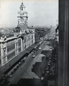
Photograph - Image, Flinders Street Railway Station, Melbourne, c1951
... Flinders Street Railway Station, Melbourne...railway station...A black and white photograph of Flinders Street Railway... Office goldfields Flinders Street station railway station ...A black and white photograph of Flinders Street Railway Station in Melbourne.flinders street station, railway station, flinders street, melbourne, railway -
 Ballarat Heritage Services
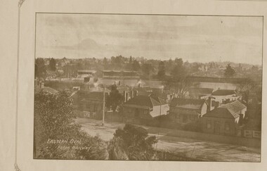
Photograph - Image, Eastern Oval from Ballarat Railway Station
... Eastern Oval from Ballarat Railway Station...Image of the Eastern Oval taken from the Ballarat Railway... Railway Station. Eastern Oval from Ballarat Railway Station ...The first cricket match at the Eastern Oval was held in 1853, and the first Australian Rules football match played on the ground was in 1866. W.G. Grace visited the Eastern Oval in the 1870s considering it the most English ground in Australia. The W.G. Grace Tree is located at the end of the historic grandstand. Former Australian Cricket captain Ricky Ponting has a tree planted at the oval also. Image of the Eastern Oval taken from the Ballarat Railway Station.eastern oval, eastern oval ballarat, cricket, australian rules football, w.g. grace tree, ricky ponting tree -
 Ballarat Heritage Services
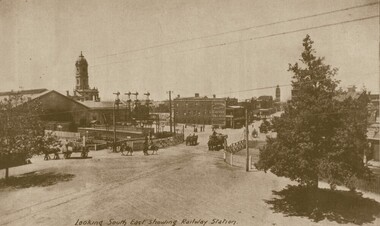
Photograph - Image, Looking South East Showing the Ballarat Railway Station
... Looking South East Showing the Ballarat Railway Station...ballarat railway station...Ballarat looking South East from the Ballarat Railway... Office goldfields ballarat railway station ballarat railway gates ...Ballarat looking South East from the Ballarat Railway Station. ballarat railway station, ballarat railway gates, lydiard street ballarat, reid's coffee palace, lydiard street north -
 Bendigo Historical Society Inc.
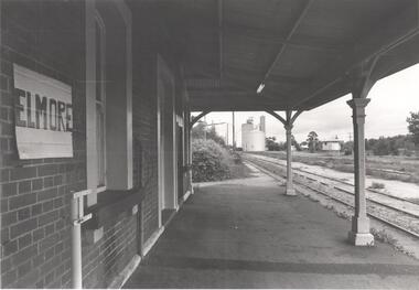
Photograph - PHOTOGRAPH. ELMORE RAILWAY STATION, 1993
... PHOTOGRAPH. ELMORE RAILWAY STATION....Photograph. Elmore Railway Station. Looking at Silos... Photograph. Elmore Railway Station. Looking at Silos beside ...Photograph. Elmore Railway Station. Looking at Silos beside the line. -
 Ballarat Heritage Services
Photograph - Photograph - Colour, Maryborough Railway Station, 2011, 06/08/2011
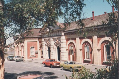
... Maryborough Railway Station, 2011...maryborough railway station...Colour photograph of a large red brick railway station... maryborough railway station Colour photograph of a large red brick ...Maryborough is a ground level premium station, featuring one side platform. It opened on 7 July 1874 The current station building was erected in 1890, with 25 rooms and a clock tower, of red brick with stucco trimming. It was initially closed on 12 September 1993, then reopened on 25 July 2010 with the reintroduction of V/Line passenger services to the station.Colour photograph of a large red brick railway station at Maryborough. maryborough, maryborough railway station -
 Ballarat Heritage Services
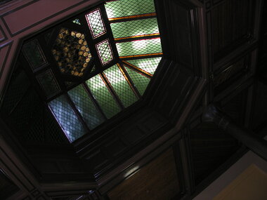
Photograph - Photograph - Colour, Ceiling and roof windows, Ballarat Railway Precinct
... Ballarat Railway Station...Colour photograph of the ceiling of the Ballarat Railway...Ballarat Railway Station Ballarat Colour photograph ...Colour photograph of the ceiling of the Ballarat Railway Station waiting room.ballarat railway station, ballarat -
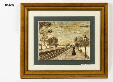 Whitehorse Historical Society Inc.
Painting, 2007
... A bark painting of Blackburn Railway Station c1918... of Blackburn Railway Station c1918. It is a copy of NP217 Painting ...Purchased by Society from Jan Robertson, a member of the Art in Bark Association Inc. The painting was copied from a photograph in our collection - NP217 by Jan Robertson of 3/15 Harrison Street Mitcham.A bark painting of Blackburn Railway Station c1918. It is a copy of NP217illustrations, bark -
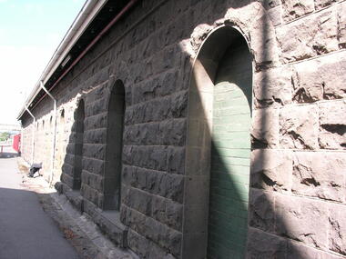 Ballarat Heritage Services
Photograph - Photograph - Colour, Goods sheds, Ballarat Railway Precinct
... Ballarat Railway Station... Railway Station. ...Ballarat Railway Station goods shed bluestone Colour ...Colour photograph of a bluestone goods shed at Ballarat Railway Station. ballarat railway station, goods shed, bluestone -
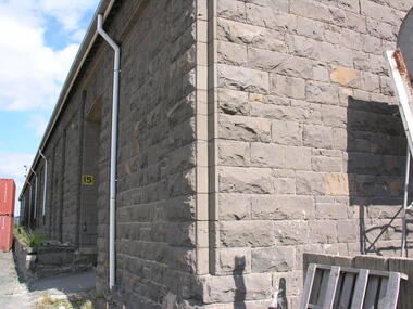 Ballarat Heritage Services
Photograph - Photograph - Colour, Goods sheds, Ballarat Railway Precinct, c2018
... Railway Station. ... photograph of a bluestone goods shed at Ballarat Railway Station ...Colour photograph of a bluestone goods shed at Ballarat Railway Station. ballarat railway precinct, bluestone, goods shed -
 Whitehorse Historical Society Inc.
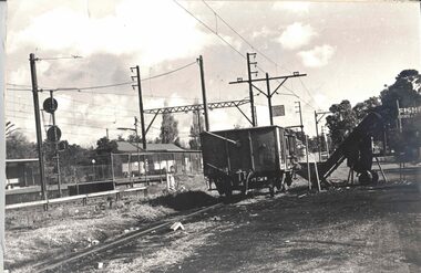
Photograph - Black and white photo, Blackburn Railway Station Goods Yard
... Blackburn Railway Station Goods Yard...Railway Station...Blackburn Railway Station showing goods yard and open...Blackburn Railway Station Goods Yard Blackburn Railway ...Blackburn Railway Station showing goods yard and open carriage.blackburn, railway station, goods yard -
 Sunbury Family History and Heritage Society Inc.
Photograph, Rosa McCall, November 2012
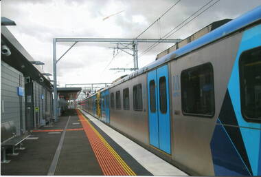
... train at a railway station. ... of the railway line was completed to Sunbury in 2012 and the Metro train ...The photograph was taken when the electrification of the railway line was completed to Sunbury in 2012 and the Metro train services commenced running in November.For 153 years Sunbury had relied on a regional train service to Melbourne. The extension of the electrified Metro service provided the town with more frequent services.A coloured scanned photograph of a stationary electric train at a railway station. metro trains, electrification, railways, sunbury -
 Bendigo Historical Society Inc.
Photograph - ESTELLE HEWSTON COLLECTION: FAÇADE OF EASTERN BENDIGO RAILWAY STATION BUILDING, FEBRUARY 1990, february 1990
... RAILWAY STATION BUILDING, FEBRUARY 1990...two colour facades of the eastern Bendigo Railway Station... OF EASTERN BENDIGO RAILWAY STATION BUILDING, FEBRUARY 1990 ...two colour facades of the eastern Bendigo Railway Station building. dated February 1990 15A façade of the eastern railway plarform building 15B entrance to the eastern railway station buildingEstelle Hewston -
Ringwood and District Historical Society
Plastic packet, PTC - Maroondah City Council, Public Transport Commission, Ringwood Railway Station Development Study, Interchange Upgrade, Community Workshops - various printed documents 1995-2013, 1995 to 2013
... Public Transport Commission, Ringwood Railway Station... Railway Station to be upgraded October 1995... - Ringwood Railway Station Redevelopment Study October 1995, Ringwood... Feasibility Study, Ringwood Railway Station to be upgraded October ...The urban consulting group commissioned Maroondah City Council and the Public Transport Feasibility Study, Ringwood Railway Station to be upgraded October 1995Various printed documents relating to PTC (Public Transport Commission), Maroondah City Council, Department of Transport - Ringwood Railway Station Redevelopment Study October 1995, Ringwood Station Bus interchange upgrade, designing new look Ringwood Station. Workshops were held for the community. +Additional Keywords: Ringwood Station Bus Interchange upgrade feed back sheet October 2011 / Ringwood Station Precinct Redevelopment Workshop held 26 July 2011 / Ringwood Station and bus upgrade December 2011 / Ringwood Town Centre South Project / Precinct Plans Planning Report. / Ringwood Town Centre Draft Report November 2000 / Ringwood Activities Community Newsletter August 2011 - Ringwood Station Update / State Government to sell Central Ringwood Railway land - Herald Sun 30 December 2013 / Ringwood Town Centre Precinct 4 Station Superblock for Railway Station July 2009 / Media release $66m station 15 April 2015 / Ringwood Station and Interchange Upgrade, Wednesday 27 August 2014 / Lifts left off upgrade plan - Leader Community Paper, 10 December 2013 / How to submit your feedback - Ringwood Station Precinct proposed concept, December 2011 / Designing a new look Ringwood Station workshop handout / State Government announces $66 million redevelopment of Ringwood Train Station, Herald Sun 6 June 2013 / Ringwood Station and bus interchange upgrade project update July 2012 / Set Concept design plans of $66 million Ringwood Railway Station over the years / Set photos of Ringwood Station taken between 2004 to 2005 / A3 drawing - Plan of Ringwood Station / A3 drawing - Ringwood Station proposed layout / A3 drawing - Old Station, Ringwood / A3 drawing - Proposed plan 2011 / A4 drawing - Final plan of Ringwood Station 2014 / A4 drawing - Proposed plan 2010 Ringwood Railway Station / A3 drawing - Proposed plan Ringwood Station with bridge across Maroondah Highway -
 Bacchus Marsh & District Historical Society
Map, Maddingley Township, Parish of Parwan, circa 1890s
... are present in the map, These include the Bacchus Marsh Railway... railway station in the township of Maddingley. The map is pasted..., the railway line and Bacchus Marsh railway station in the township ...Maddingley is a locality or township within the broader township area of Bacchus Marsh. This map is not dated. However features in Maddingley which appeared in the 1880s and 1890s are present in the map, These include the Bacchus Marsh Railway Station and the Bacchus Marsh Showgrounds. The main residential and commercial area of Maddingley is shown on this map in an area bounded by Bacchus Street, Barry Street, Griffith Street and Maddingley Road. Other streets visible are Franklin Street, Inglis Street, Labilliere Street, McCrae Street, Moore Street and part of Station Street.A single page paper map showing land allotments, streets, rivers, creeks, park lands, the railway line and Bacchus Marsh railway station in the township of Maddingley. The map is pasted into a bound volume containing 76 maps or plans in total. bacchus marsh victoria maps, maddingley victoria maps, land use, maddingley victoria history -
 Wodonga & District Historical Society Inc
Photograph - Fred Rochow Railways Collection - Cudgewa as it was, 27 January 1989
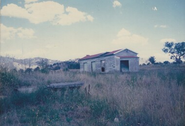
... related to the operation of the Wodonga Railway Station including...What remains of the Cudgewa Railway Station taken... to the operation of the Wodonga Railway Station including different types ...The Fred Rochow Railways Collection incorporates photos related to the operation of the Wodonga Railway Station including different types of trains and railways staff C. 1930 – 1990. It was donated to the Wodonga Historical Society by Fred Rochow, a railwayman who spent many years based in Wodonga. He joined the Victorian Railways on 17th June l947 and retired in 1988. For some time, he was a member of the Australian Federated Union of Locomotive Enginemen and served a term as a member of the Trades Hall Council. He had an extensive knowledge of the struggles that took place to achieve better conditions for railway workers. Fred worked for many years as a fireman and then worked his way up the ranks to driver, experiencing many changes from the days of steam locomotives through to diesel trains, locomotives and even the modern XPT train. He worked throughout Victoria at different stages of his career, with his final working years focused on the northeast of Victoria and the Albury to Melbourne line. After his retirement, Fred continued to share his love of steam miniature trains with the community. Cudgewa Line -The Cudgewa railway line opened in stages between 1889 and 1921. The first section from Wodonga to Huon opened on 10 September 1889. It was extended to Bolga on 18 July 1890, Tallangatta on 24 July 1891, Shelley on 13 June 1916 (the highest station in Victoria), Beetomba on 10 April 1919 and Cudgewa on 5 May 1921. In 1919, the line was used to carry materials for the construction of Hume Weir, and three years later a spur line connecting Ebden to the weir was opened. In the 1960s, Cudgewa became the railhead of materials for the Snowy Mountains Scheme. The last passenger service from Wodonga to Tallangatta ran on 30 September 1961 The turntable and passenger platform at Cudgewa were abolished in 1976.This collection has local and statewide significance as it captures images of trains, locomotives and personnel who operated the railway services in Wodonga and throughout Northeast Victoria. The railways played a critical role in opening up Victoria and connecting Australia for trade, business, social communication and transport.What remains of the Cudgewa Railway Station taken in January 1989. A disused shed in a paddock is all that remains of a once busy station.railways wodonga, fred rochow, cudgewa station, high country railway line -
 Otway Districts Historical Society
Photograph, Near Weeaproinah (Dinmont) railway station, 1907, 1907
... Near Weeaproinah (Dinmont) railway station, 1907...Photograph, B/W, A4. Near the Weeaproinah railway station...; Photograph, B/W, A4. Near the Weeaproinah railway station (later ...Photograph, B/W, A4. Near the Weeaproinah railway station (later known as Dinmont railway station) in 1907. Note the trolley with two men aboard following the line on the left-hand side.weeaproinah; dinmont; railways; -
Glen Eira Historical Society
Letter - O’Neill College, Nagle Avenue, 2, Elsternwick
... Gardenvale Railway Station... Estate Elsternwick Railway Stations Brentani Avenue Caulfield ...2 articles related to O’Neill College. Photocopy of advertising leaflet for the auction of house- blocks, on the O’Neill College Estate, Elsternwick Auction held 08/04/1922. Copies of 4 letters dated 17/07/1936 to 12/04/1937 from the Victorian Public Health Dept. to the Mother Superior, O’Neill College, regarding alterations to the college buildings.o’ neill college estate, elsternwick, burke t. m., subdivisions, railway crescent, nagle avenue, denver court, robinson c.h., gardenvale railway station, presentation novitiate, auctions, catholic schools, convents, nuns, colleges, school houses, building construction, building permits, public health department, o'neill college, o'neill college estate, elsternwick railway stations, brentani avenue, caulfield city council -
 Glen Eira Historical Society
Article - Bentleigh East Primary School
... Railway Stations... Supply Salmagundi Tamrakis Socrates School libraries Railway ...This file contains 5 items. A limited edition of a book "A History of the Bentleigh East Primary School No. 2083 formerly Bentleigh formerly East Brighton 1878-1978" published to mark the centenary of the Bentleigh East Primary School celebrated from 1 – 5th August 1978. The book was compiled by the Principal Peter Morris and is a collection of incidents, reminiscences and anecdotes arranged in chronological order to capture the character of the differing periods through which the school passed. It provides an insight to the development of the area and of the school and includes a list of school principals from 1878 – 1978, an honor roll for WW1 students etc. Notes on the Camm family who donated the School Centenary Book A newspaper article on the centenary celebrations. The article is undated and the source is not known. It includes 2 photographs of the celebrations. A name badge for Duchie Laven issued for the centenary. The badge is on pink cardboard. A Black + White school photograph taken in 1948. Josephine and Wilma Newman are identified in the photograph.malane thomas market gardener, atkinson william – head teacher 1878 – 1883, initial school staff, jack margaret, stevens eliza (pupil teacher), water supply, mills henry (prominent head teacher), craig robert district inspector, centre road, primitive methodist church 22/07/1884, tram lines, taylor mr., head teacher list, shelter sheds., joyce colin dr., thiele mr. (head teacher), north road state school, ormond state school no 3074, east bentleigh state school, east brighton state school no. 2083, bentleigh state school no 2083, bentleigh east primary school no 2083, school 213 brighton east, bentleigh elementary school no 2083, bentleigh west state school no 4318, coatesville primary school, tucker road moorabbin primary school, bent thomas sir, honor lists, honour book, awards, snowball o.r. mla gilbert mr. head teacher, brighton gas lighting, sloyd classes, gilbert mr. (head teacher), cross bob (pupil), school strap, henderson w. (district inspector), school rooms, school work books, schools, school concerts, school committees, caretaker’s residence, fencing, higgins a., higgins stan, bentleigh public hall, marriott william (chairman school committee), bentleigh theatre, old scholars, trenches 1937 (slit), donald j.r. (head teacher), war savings certificates, shelter pavilions, bristol units – classrooms, redmond mr (head teacher), school pedestrian crossings, sound systems, school canteen, world war 1914 – 1918, electricity supply, salmagundi, tamrakis socrates, school libraries, railway stations, education, school rolls, market gardens, cattle – nuisance, bushrangers, toll gates, chinese school, chinese community, school curriculum – historical, flora, aborigines, snakes, migrant teachers, japanese language, rats, caretaker’s residences, fencing, cattle, horse racing, caulfield military hospital, advertising, street lighting, anglican school st stephens, chinese christian church arthur’s seat road (now nepean hwy), st john’s anglican church bentleigh, hit & miss hotel, live & let live hotel, plough & harrow hotel, moorabbin district roads board, army huts, higgins stan mr, . marriott william mr, cremean mr. mla, arnett kevin, vanderlaven vanderlaven adrian, vanderlaven josephine, laven fredericha willamena, laven adrian, laven duchie, newman wilma, newman josephine, camm josephine, marshall gladys, neville gladys, holis ivy, monroe victor, duckmanton keith, tram lines - mordialloc sandringham, school paper, public works dept., springthorpe j.w. dr., vosey joseph, camm terry, camm josie, barrenger elsie, bentleigh oval, race course east bentleigh 1899, keys's hotel, unveiling of honor book and cabinet 25/08/1922 -
Glen Eira Historical Society
Document - MCKINNON
... Railway Stations... Schools Progress Associations Ormond Railway Stations Residential ...Information on the naming of McKinnon downloaded from OnlyMelbourne Website 1/2/2011.mckinnon, secondary schools, progress associations, ormond, railway stations, residential development, bentleigh, railway buildings, demography, killearnan, vineyards, hotels, primary schools, agriculture, clubs and associations -
Glen Eira Historical Society
Plan - Nettalie
... Elsternwick Railway Station... Rosstown Railway Elsternwick Railway Station Caulfield Railway ...An A4 photocopy of the 'Plan of the Caulfield Road District' dated 1867. This plan shows the location of the properties owned by A Shaw and Blundell on Balaclava and Orrong Roads where Nettalie is situated. The plan includes all the landowners listed where their property was, the street names and other landmarks of 1867 including railways, hotels and reserves.caulfield, caulfield north, elsternwick, st kilda east, parish of prahran, parish of moorabbin, caulfield road district, melbourne and brighton railway, rosstown railway, elsternwick railway station, caulfield railway station, rosstown railway station, murrumbeena railway station, baptist church, paddy’s swamp reserve, cemetery reserve, leman swamp reserve, caulfield racecourse reserve, brighton cemetery, the vine caulfield hotel, the tam o’shanter hotel, melbourne hunt hotel, royal hotel, hotham street, horne street, nepean highway, north road, orrong road, dandenong road, princes highway, kooyong road, alma road, inkerman road, balaclava road, glen eira road, glen huntly road, hawthorn road, cemetery road, bambra road, redan road, kambrook road, neerim road, booran road, racecourse road, grange road, koornang road, murrumbeena road, crosbie road, kangaroo road, poath road, ford w, lempriere, cople j, riddell j c, manifold j, testar t, billing r h, semple, blundell, shaw a, butchart g, stephen j w, stephen g sir, hart j, duncan g, blackie r, stephen f, mccombie t, woollaston h, higgins j, lloyd j c, daish j, mcleod j, hughes d, wilson a, jamieson g, webb g h, renwick s, pennington h, dunn j, kirkpatrick w, ricketson w, toad a, sayce j, watts t, widgery, store, guess j, anketell j, clack j, sissen w, clayton g, dickson d, bevan j, hart t, anderson j, hart mrs, webb h, masters s, waghorn j, hemming c, hiam c, farquhar w, newing t, payne t, cooper r, snipe s, chambers j, forster w, summers r, harriman b, warrick, o’connell, long j, peck r, cochrane c, murray ross w, evans c, kennedy j, maclean n, forster, lyall w, dean j, newton h, looker w, baker c, johnston, crosbie j, kerr, jones, parr, nelson c, montgomery l, parsons w, james j c, sibon c, smith sydney w, plans, maps, land subdivisions, land use, settlements, roads and streets, hotels, churches, police stations, post offices, land surveys, railway stations, railways, schoolhouses, commerce, clergy residences, official buildings, local government, road districts -
Glen Eira Historical Society
Document - GARDENVALE ROAD, 77, GARDENVALE
... Railway stations... of the building of Gardenvale Station in 1906 and the railway underpass ...This file contains research by the Brighton Historical Society into this property: 1/A photocopy of a typed document describing the history of the property at 77 Gardenvale Road, with a brief history of Gardenvale, including the impact of the building of Gardenvale Station in 1906 and the railway underpass in 1927. Before the station was built, the area had many market gardens, many of which were sub-divided after the station was built. Includes a list of past owners/residents of 77 Gardenvale Road (previously number 49). 2/Also includes a carbon copy of this document which is faded. 3/Handwritten notes covering mostly same information. By Hilary Bullock and Rosalind Landells of the Birghton Historical Society, printed on 22 July, 1987.market gardens, railway lines, gardenvale station, gardenvale road, o’neill family, chinese community, lempriere’s paddock, martin street, judd frederick, drayton me, agg george, agg family, agg mary, agg winifred, agg fanny, railway stations, macaulay misses, gardenvale