Showing 607 items matching "recreational"
-
 Parks Victoria - Mount Buffalo Chalet
Skates
Ice skates used to skate on Lake Catani. Ice skating was a popular activity for guest and visitors to Mt Buffalo. Ice skates were provided for hire by the the first Lessee of the Chalet, John Newton and also Norwegian born Hilda Samsing, who took over from him in 1919 and did much to pioneer and promote winter sports in the Victorian Alpine region . Ice cover on the Lake has not been sufficient for safe skating for many decades. 'After its initial popularity, skating at Mount Buffalo dwindled in the post-war years. According to Museum Victoria curator, Michelle Stevenson, few collections hold historic ice-skates, so any early examples identified in the Chalet collection will be important for their rarity." (Pg 94. Historica) 'Ice-skating was a popular recreational activity in the later nineteenth and early twentieth centuries...According to Michelle Stevenson, Australian Collections hold little material culture relating to its practice other than images and film. The few pairs of ice skates in the Chalet collection, which are in good condition, are important for their rarity as well as for illustrating the popularity of skating on Lake Catani prior to WW2.' Pair of black leather ice scates, mounted on wall. Skates feature white laces, metal blades and brown leather reinforcing area around laces and ankles.Boots are stffed with 1993 newsprint.On skate blade, "Made in Canada 11 1/3 CCM / Senior A" On boot sole , "Made by J Molony " plus worn name label. -
 Kiewa Valley Historical Society
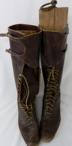
Boots Riding Women's, Circa 1950's
This pair of "adjustable" boots came from the 1950's era in which the majority of footwear was either locally manufactured or imported from England or Europe. Quality hard wearing leather was a rural necessity especially for the cattle mustering activity in the Kiewa Valley and the Bogong High Plains region. The late 1900's provided a cheaper made riding boot from Asia, however many rural based riders still prefer an Australian made boot. The better quality (stronger stitching) of Australian boots is the main considerations of "stock horse riders". In 1947 a scientific research project started to provide an impact analysis of any damage to alpine vegetation by cattle grazing in the Alpine regions incorporating the Bogong High Plains area. This monitoring is the longest running ecological study ever undertaken in Australia. From this study, compelling evidence was presented to the Victorian Government to cease cattle grazing in the Alpine regions including the Bogong High Plains. All grazing was banned by the Victorian Government in 2005. Recreational horse riding within the Bogong High Plains is still permitted.These pair of women's riding boots are very significant to the Kiewa Valley as the boots were worn by one of the descendants of a pioneer family living and operating a cattle station before the SEC Hydro Electricity Scheme opened up the semi remote rural location in the 1950's. These boots were worn during the annual six weeks (approx.) mustering of cattle in the Bogong High Plains location (Victorian Alps region). The owner of these boots was Clare Roper, part of the Roper Family who built a "lodging" hut on the "High Plains" for accommodating riders during the periods (up to six weeks) when controlling grazing cattle during the summer muster seasons. It was unusual for women in the early to mid 1900's to go up on the High Plains to join the muster, which Clare Roper often did. These boots have high historical significance and good interpretive capacity.These brown "knee high" lady riding boots, are fastened by long "boot" laces which go from the base of the "fastening" position to a boot height of 22 cm. At the top end of the boot is a leather flap which crosses the front section of the boot and is fastened to the outside leg region by two straps. These provide the wearer with an adjustable tie. The boot has a "tongue" of 22 mm long. The boot has six pairs of metal boot lace "hooks" and eight pairs of boot lace "eyelets".ladies riding boots. cattle mustering footwear. rural footwear. cattlemen. bogong high plains. roper family. horses. -
 Eltham District Historical Society Inc
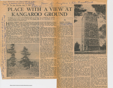
Folder, Basil Hall, 1999
Original newspaper article from "The Age" May 11, 1963. Place with a view at Kangaroo Ground by Basil Hall about the construction of the War memorial. The Hall family resided at "Fairview" Panton Hill in the 1920s. Hall was a Eltham Shire Councilor in the 1920s and was associated with the Eltham Shire war Memorial Tower Bulding Committee from 1924 to 1926. Photocopies from "The Road to Gundagi" by Graham McInnes (Hamish Hamilton, 1965), Chapter 9 pages 132 - 153 an autobiography in which the author reminiscences about visiting the Hall family at "Fairview" in Panton Hill as a child. References also to Watson's Creek where MacPherson Robertson ("The Chocolate King") had a summer home, the Shannons, Shanhun and McLaughlin familes. Includes description of the day that Hurstbridge was declared a township (May 26th, 1924), a ralway journey, picnics and rabbiting. McInnes' reminiscences about the periods of his childhood spent visiitng the Hall family in Panton Hill in the 1920s are a rare first hand glimpse into the recreational, social and municipal life in the 1920s within the this rural area within the Shire of Eltham. "Road to Gundagi" was the first of three widely acclaimed autobiographies.Original newspaper article Photocopies, 12 pages.HG Booklet 36basil hall, click here to add keywords, cr. basil hall, eltham war memorial, graham mcinnes, harry gilham collection, hurstbridge, kangaroo ground tower building committee, macpherson robertson, mclaughlin family, panton hill, picnicing, rabbiting, reminiscences, shanhun family, shannon family, shire of eltham war memorial, war memorial tower, watson's creek -
 City of Moorabbin Historical Society (Operating the Box Cottage Museum)
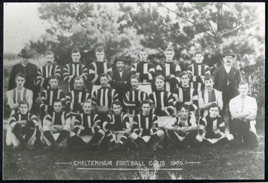
Photographs, x 3 Black & White Cheltenham Football Club 1909,1913, 1946, 20thC
Known as the Rosellas, the early Cheltenham Football Club sides began playing on a regular basis in 1890, and would travel long distances by steam train to play country teams, such as Ballarat where they would arrive at their destination, play the match, socialize then return to the station. Opposition players and supporters would give three hearty cheers on their departure. The Cheltenham home games were played on a paddock on the corner of Park and Charman roads in Cheltenham. In 1907 the Cheltenham progress committee made an application to the board of land works for land in Weatherall Road for recreational service to the public. That application was received and granted, then developed where Cheltenham Recreational Reserve now stands. The land in the early days was virgin bush and the response for voluntary help to clear the area was outstanding. Nearly all the market gardeners in the district along with horses, ploughs, axes, shovels completely cleared the area in three weeks. The Moorabbin council then leveled the playing area and erected a post and rail fence around the ground. Pine tree shrubs were then planted on the west side of the ground. The ground was opened in 1909 and the first Cheltenham side entered in the newly formed Federal Football Association along with seven other foundation members, Mordialloc, Mentone, Moorabbin, Frankston, Glenhuntly, Elsternwick, and Ellindale. The grand final for that year, 1909 was a hard encounter between Cheltenham and Ellindale with Cheltenham coming out victors, thus becoming the inaugural Federal Football Association premiers. Cheltenham went onto win five senior premierships in the Federal Football Association by the end of the 1920s, they won the flags in 1909, 1911, 1913, 1922 and 1925, with the late Percy Woff playing in all 5 premiership sides and was captain in 1922. 1928 saw the start of an outstanding career from our oldest living player Tom Connor. Cheltenham continued to win premierships in the 1920’s and 1930’s with juniors taking out the 1929 and 1933 flags, under the guidance of Woff, and that continued in 1934 when Cheltenham took out the 1st XVIII and 2nd XVIII premierships. Cheltenham produced its only Brownlow medallist in Peter Box who played in the late 1940s, before going to Footscray where he became a champion. The 3rd XVIII went through the season undefeated in 1974 winning the premiership, with Trevor Barker a key player before going to St Kilda the following year. The club won three senior premierships under coach Barry White in 1992, 1993 and 1995. ( from CFNC website 2019) Cheltenham Football Club was formed 1890 and succeeded in winning many Premierships as a member of the Federal Football Association, Outstanding players Peter Box Brownlow Medalist 1956 Footscay VFL, , Trevor Barker and Kevin Roberts St Kilda VFL.3x Black & White photographs of the players in the Australian Rules Cheltenham Football Club 1909, 1913 and 1946 extra photo of Peter Box Folio 10 MAV 01059a) CHELTENHAM FOOTBALL CLUB 1909 Cheltenham Football Club 1909. Back row: A Chandler, committee member; R. Robertson, back-pocket; J. Harris, half back flank; J Adams, ruck and forward-pocked; M. J. Monk, club president; L. Woff, back-pocket; W. Adams, ruck and back-pocket; P. Woff, rover and forward-pocket; A Monk, committee member. Middle row: W. Hore, back pocket and ruck; A. Towns, half-forward flank; W. Carson, full back; F. Andrews, captain-half forward flank; H. Butler, centre half back; J. Warburton, centre half-forward; A. Slater, half-back flank; F. Fisher, half-forward flank; C. Sherwood, trainer. Front Row: G Gouldthorpe, wing; H. King, full-forward; W. Johnston, ruck and forward-pocket; P Spears, rover and forward-pocket; F. Bichl, wing; A. Bichl. rover and forward-pocket; F. Butler, centre player. Courtesy, Lionel Seal. ( from CFC website 2019) b) CHELTENHAM 1913 PREMIERS c) CHELTENHAM -1946 / Back row - J. Fisher, G.Corrigan, N.Hocking, F.Virtue, R.Craven, L.Baker, M.Blundell / 2nd Row - J.Phillips, T.Connor, E.Hawkins, A.Blakely, G.Baker, A.Dark, J.Barker, D.Craven, J.Pickering, P.Cameron,/ W.Hicks, G.Hoskings, R.Beihl, A.Hubbard, R.Kier, C.Russell. / Front Row - Clark Taylor, J.Slade, N.Niel, J.Brooks, T,Butler, H.Hosking, C.Hacusler, E.Hornibrook, W.Briggs, B.Russell, L.Biehl, / W Ripponcheltenham football club, australian rules football, victorian football association, victorian football league, smith j l; smith mary ann, stanley helen, , chaff cutter, horse drawn carts, toll gates brighton, motor cars 1900, steam engines, early settlers, bentleigh, parish of moorabbin, city of moorabbin, county of bourke, moorabbin roads board, shire of moorabbin, henry dendy's special survey 1841, were j.b.; bent thomas, o'shannassy john, king richard, charman stephen, highett william, ormond francis, maynard dennis, market gardeners, vineyards, orchards, cheltenham, two acre village, holloway josiah,, woff percy, connor tom, box peter, barker trevor, white barry, browlow charles, -
 Eltham District Historical Society Inc
Film - Video (DVD), Melbourne and Metropolitan Board of Works, Yarra River Conference Proceedings; a Board of Works centenary event, 13-16 April 1991
Yarra River Conference History Segment [Noted on VHS tape jackets "Due to unavoidable circumstances, the quality of these tapes in some setions is less than desired."] The Yarra River Conference, organised by the Board of Works as part of the Centenary Celebrations, was held in the Board's Head Office Theatrette from 13-16 April, 1991. A segment of the Conference focussed on the role that the Yarra River has played in relation to the historical development of Melbourne. Conceived and presented by a group of prominent historians as a chronological 'trip down the river in time', and profusely illustrated with slides, this segment traced the various impacts that urban and rural growth, development of marine commerce, recreational uses, and environmental problems have had on the Yarra during a century and a half of European occupation. As no formal written paper of this combined presentation is available, these two video-tapes provide a record for anyone who has an interest in tis fascinating aspect of the Yarra's history. The speakers who combined to present this segment are identified on the cover of Tape 2. Tape 1 (2 hours) 1838-1863 Deputy ?? to Utility Early navigators of the Yarra River; developing the port of Melbourne; the gold rush and its effect on the new colony; punts and bridges; water supply; pollution of the Yarra; the discovery of gold and early settlement of the Yarra valley; floods of 1839 and 1863. 1863-1891 Formation of the Harbour Trust; Coode Canal; pollution of the Yarra by industry; aborigines, gold miners, timber getters in the Upper Yarra areas; bridges; the flood of 1891. Tape 2 ( 1 1/2 hours) 1892-1934: People Begin to See Beauty and Romance to the River Henley-on-Yarra; realignment of the Yarra; MMBW is responsible for a sewerage system; new docks to cope with increased overseas trade; development of recreational parks; new reservoirs; timber production and timber tramways; bushfire; flood of 1934. 1935-1970: The River is Neglected Still, Except When it Proves Useful Bushfirs of 1939; the end of many sawmills; birth of tourism; increased interest in conservation and preservation of land for open space; further augmentation of water supply system; birth of containerisation changes the port; environmental concerns gain momentum. Speakers Dr Tony Dingle *, Department of Economic History, Monash University Dr Carolyn Rasmussen *, History Consultant Prof. Graeme Davison, History Department, Monash University Mr. Tom Griffiths, Lecturer in Public History, Monash Uiversity Mr. Patrick Miller, History Consultant Mr. Colin Jones, Author and Historian * Co-authors of the Board's history, 'Vital Connections'.video recording, yarra river, conference proceedings -
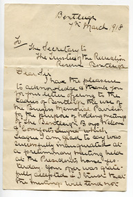 City of Moorabbin Historical Society (Operating the Box Cottage Museum)
Letter - The Bentleigh Soldier's Welcome & Comforts League 1918
A letter sent to the Secretary of the trustees of the Bentleigh Recreation Reserve, from Lucy Wood, for the Bentleigh Soldier's Comfort League requesting the use of the Burgess Pavilion for the Leagues meetings. The Bentleigh Soldier’s Comforts League is but one example of many other organisations that made use of the pavilion. After the League’s inaugural meeting a letter was sent to the Trustees of the Recreation Preserve Bentleigh requesting the use of the pavilion to hold their meetings. The objects of the Bentleigh Soldier’s Comforts League were: 1. To provide comforts for Bentleigh boys on active duty 2. To ensure a suitable public welcome upon their return 3. To visit the sick and wounded ones at the Military hospitals A committee of local ladies formed a committee, An amount of 2s was allotted to each worker who endeavored by personal effort to increase that sum. A Gymkhana, in association with the Equestrienne Club, was held to raise funds to help the return soldiers and to send Xmas boxes to the soldiers on active duty abroad. Lucy Wood (1872 - 1956) was the wife of William Howard Wood (1868 - 1947). William and Lucy lived in Jasper Road opposite the recreational reserve. William was a poultry breeder and a local accountant, auditor, real estate, insurance and general commission agent.The efforts made by the citizens of the Shire of Morrabbin to send comforts to the troups overseas during WWI, and to welcome home the soldiers.A hand written letter wwi, city of moorabbin, lucy wood, burgess pavilion, bentleigh recretional reserve, william burgess, fundraising, xmas boxes, bentleigh soldier’s comforts league, bentleigh, moorabbin -
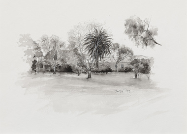 Bayside Gallery - Bayside City Council Art & Heritage Collection
Work on paper - ink and watercolour, Annette Meikle, Semco Park, 1977
In 1977, artist Annette Meikle undertook a commission to illustrate a book recording stories of places and people in the Bayside area. It was published in 1978 as Sandringham Sketchbook, with text by Elizabeth Waters. The sketches were intended to record remaining examples of Bayside’s early architecture and environment, as well as reflect newer architectural changes. Meikle went on to donate 22 of these sketches to Bayside City Council in 2003. Semco Park was a model of exemplary modern business in the 1920s. Located on Cheltenham Road, Black Rock, then considered to be an outer suburb, the property was home to Semco, a manufacturing and importing business of paper goods and cotton fabric items. The business’s governing director, Charles Mylius, wanted a firm that treated staff with fairness, created healthy and spacious working sites and offered recreational facilities. The site contained a factory as well as three houses for staff, a park with lawns, trees and flowerbeds, a cricket oval and a canteen serving hot food. Staff enjoyed soft background music played in the factory, and benefited from a superannuation scheme. Semco Park was sold to developers in 1977 but the business continued until the early 1990s with the office moving to Mulgrave, while factory work shifted to New Zealand.Annette Meikle, Semco Park 1977, ink and watercolour, 25.8 x 35.7 cm. Bayside City Council Art and Heritage Collection. Donated by the artist, 2003annette meikle, sandringham sketchbook, elizabeth waters, semco park, semco, cheltenham road, black rock -
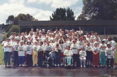 Melbourne Legacy
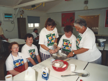
Photograph, HDC Camp 1991, 1991
Every month Legacy's handicapped dependents are invited to go on outing for take part in recreational and educational activities. These programmes aim to develop independence and thus lessen the need for reliance on others for simple routine functions. Once a year there is a two week camp at Somers Camp (believed to be Somers School Camp). This photo is from 1991. An article in the widows' newsletter in 1992 explains more detail on the 1992 camp. The article mentions that the annual camps run for two weeks at Somers Camp. It is a wonderful gathering of Junior Legatees, Legatees, and dedicated helpers. 50 junior legatees attended this camp (in 1992) with the personal attention almost one-to-one. With ages ranging from 22 to into the 60s, Legacy has to ensure it caters for the differing needs. Legatees headed by Camp Chief, Jim Hammon and Chairman of the Handicapped Dependents Committee, Merv Tickell, were supported by two Camp Co-Ordinators and 50 helpers known as 'leaders'. Many of the leaders are people in the workforce wishing to give something back to the community. Junior Legatees are organised into groups. They participate in horse-riding, swimming, golfing, strawberry picking, and many other activities. Photos were in a scrapbook of photos spanning 1983 to 1991.A record of the type of activities Legacy provided for the handicapped dependents of the Legacy families. Colour photo of a HDC camp and a yellow paper label.Handwritten in blue pen ' HDC Camp Jan 91'junior legatee outing, hdc, somers camp -
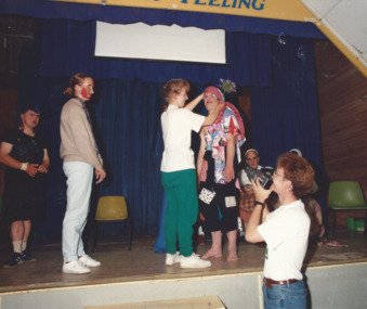 Melbourne Legacy
Photograph, HDC Camp 1992, 1992
Photos from a camp for handicapped dependents in January 1992. These photos show costumes and a stage production. Other photos from the camp are at 01560, 01562, 01563 and 01564. Some appeared in the newsletter in March 1992. The article mentions that the annual camps run for two weeks at Somers Camp (believed to be Somers School Camp). It is a wonderful gathering of Junior Legatees, Legatees, and dedicated helpers. 50 Legatees attended this camp with the personal attention almost one-to-one. With ages ranging from 22 to into the 60s, Legacy has to ensure it caters for the differing needs. Legatees headed by Camp Chief, Jim Hammon and Chairman of the Handicapped Dependents Committee, Merv Tickell, were supported by two Camp Co-Ordinators and 50 helpers known as 'leaders'. Many of the leaders are people in the workforce wishing to give something back to the community. Junior Legatees are organised into groups. They participate in horse-riding, swimming, golfing, strawberry picking, and many other activities. Every month Legacy's handicapped dependents are invited to go on outings or take part in recreational and educational activities. These programmes aim to develop independence and thus lessen the need for reliance on others for simple routine functions. Photos were in a scrapbook of photos spanning 1983 to 1991.A record of the type of activities Legacy provided for the handicapped dependents of the Legacy families. Colour photo x 3 of a HDC camp, a label and an article in the newsletter.Handwritten in blue pen 'HDC Camp -Somers / Jan 1992 / Camp Chief: L/ J Hammon / Co-ordinator Julien Hardy-Smith / Photo Eric Wadsworth / 51 J/Ls'junior legatee outing, hdc, somers camp -
 Melbourne Legacy
Photograph, HDC Camp 1992, 1992
Photos from a camp for handicapped dependents in January 1992. These photos show cooking classes. Other photos from the camp are at 01560, 01561, 01563 and 01564. Some appeared in the newsletter in March 1992. The article mentions that the annual camps run for two weeks at Somers Camp (believed to be Somers School Camp). It is a wonderful gathering of Junior Legatees, Legatees, and dedicated helpers. 50 Legatees attended this camp with the personal attention almost one-to-one. With ages ranging from 22 to into the 60s, Legacy has to ensure it caters for the differing needs. Legatees headed by Camp Chief, Jim Hammon and Chairman of the Handicapped Dependents Committee, Merv Tickell, were supported by two Camp Co-Ordinators and 50 helpers known as 'leaders'. Many of the leaders are people in the workforce wishing to give something back to the community. Junior Legatees are organised into groups. They participate in horse-riding, swimming, golfing, strawberry picking, and many other activities. Every month Legacy's handicapped dependents are invited to go on outing for take part in recreational and educational activities. These programmes aim to develop independence and thus lessen the need for reliance on others for simple routine functions. Photos were in a scrapbook of photos spanning 1983 to 1991.A record of the type of activities Legacy provided for the handicapped dependents of the Legacy families. Colour photo x 3 of a HDC camp, a label and an article in the newsletter.Handwritten in blue pen 'HDC Camp -Somers / Jan 1992 / Camp Chief: L/ J Hammon / Co-ordinator Julien Hardy-Smith / PhotoEric Wadsworth / 51 J/Ls'junior legatee outing, hdc, somers camp -
 Melbourne Legacy
Photograph, HDC Camp 1992, 1992
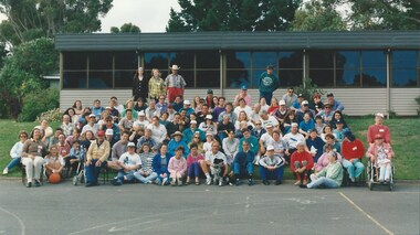
Every month Legacy's handicapped dependents are invited to go on outing for take part in recreational and educational activities. These programmes aim to develop independence and thus lessen the need for reliance on others for simple routine functions. Once a year there is a two week camp, this is believed to be Somers School Camp. These photos are from 1992. An article in the widows' newsletter in 1992 explains more detail on the 1992 camp. The article mentions that the annual camps run for two weeks at Somers Camp. It is a wonderful gathering of Junior Legatees, Legatees, and dedicated helpers. 50 junior legatees attended this camp (in 1992) with the personal attention almost one-to-one. With ages ranging from 22 to into the 60s, Legacy has to ensure it caters for the differing needs. Legatees headed by Camp Chief, Jim Hammon and Chairman of the Handicapped Dependents Committee, Merv Tickell, were supported by two Camp Co-Ordinators and 50 helpers known as 'leaders'. Many of the leaders are people in the workforce wishing to give something back to the community. Junior Legatees are organised into groups. They participate in horse-riding, swimming, golfing, strawberry picking, and many other activities. Photos were in a scrapbook of photos spanning 1983 to 1991.A record of the type of activities Legacy provided for the handicapped dependents of the Legacy families. Colour photo x 5 of the HDC camp in January 1992 and a white paper label.Label says 'January is holiday time for Legacy's Junior Legatees. Children aged 7 to 17 join together for a 10 day action packed holiday at Camp Howqua and Legacy's disabled dependants enjoy quality time at Somers Camp. Legatees, members of the Melbourne Legacy Leadership Group and volunteer helpers ensure all have a memorable time.'camp, handicapped dependents, somers school camp -
 Bendigo Historical Society Inc.
Map - Laminated map of Lake Eppalock at full capacity. Map 'E'
John Perry Collection. Laminated map of Lake Eppalock at full capacity. Black and white. The dam was built by the State Rivers and Water Supply Commission of Victoria. The dam wall height is 45 metres (148 ft) and the main embankment is 1,041 metres (3,415 ft) long. At 100% capacity the dam wall was designed to hold back 304,651 megalitres (6.7014×10¹⁰ imp gal; 8.0480×10¹⁰ US gal) of water. The surface area of Lake Eppalock is 3,011 hectares (7,440 acres) and the catchment area is 2,124 square kilometres (820 sq mi). The controlled spillway is capable of discharging 8,040 cubic metres per second (284,000 cu ft/s). Lake Eppalock supplies both stock and domestic water to the Campaspe irrigation district. It also serves as a water supply to Bendigo and Heathcote and, in more recent times, Ballarat. The lake is a major attraction for those engaging in watersports, with a number of tourist parks and accommodation facilities available. Permissible activities on the lake include high-speed boating, water skiing, sailing, canoeing, fishing and swimming. The lake's water levels were low for approximately eight years between 2002 and 2010 during a prolonged drought, which restricted the amount of recreational activity until rainfall in the latter half of 2010 returned the lake to 100 percent capacity. Built between 1961 and 1964, Lake Eppalock remains the only water storage on the Campaspe River system.map, eppalock, water, dam, reservoir -
 Melbourne Legacy
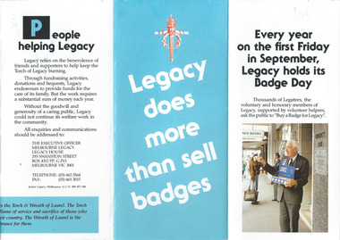
Pamphlet, Legacy does more than sell badges
A brochure promoting Legacy in the 1990's. Some of the text includes sections on How is Legacy special?; Legacy and the young; Legacy and the Aged. "Legacy and the young. Legacy is committed to the nurturing of its young members, known as Junior Legatees. Legacy helps to make sure stye get the education their fathers would have wished for them and to ensure their families enjoy a normal lifestyle. In addition to the 3,000 Junior Legatees throughout Australia, Legacy also cares for the handicapped dependants of its "family". Recreational outings and educational programs are arranged on a monthly basis. These activities aim to develop self-dependence and once a year, a two-week holiday camp is held - a highlight of the year - and lifelong friendship are often made. / For all its young members, healthy outdoor activities are arranged, financial aid, counselling, tutoring and guidance are given to ensure they are able to make the most of the opportunities open to them. Legacy and the Aged. Nowadays, the Australian population has a large proportion of elderly. The majority of Legacy widows had husbands who served in the World Wars. And so Legacy's emphasis has shifted to the needs of the ageing widows. . . Legacy widows meet for a wide range of activities, including cards, crafts, indoor bowls and theatre excursions. . . This represents a valuable social network and complements the volunteer care given by Legatees."A brochure that promotes Legacy in the 1990's.Colour brochure "Legacy does more than sell badges", folded into 4 sections.legacy promotion, fundraising -
 Eltham District Historical Society Inc
Document - Property Binder, 855 Main Road, Eltham
Individual Research Project, Catherine Loftus-Hills 1982: To what extent is the Eltham Town Park successful in providing a recreational facility for the entire community? Newspaper article: Diamond Valley News, 24 August 1982, Byways of History, Early view of Little Eltham, illustrated by photograph sometime 1902-1920. Newspaper article: Diamond Valley News, 24 August 1982, Pauline thrives on work, Australian Labor Party member of Victorian parliament. Newspaper article: unidentified, undated: Many attempts to change name, letter from Frank Burgoyne. Newspaper article: unidentified, undated: Anger over park renaming. Photocopy letter from Office of the Place Names Committee to Eltham and District Historical Society, 25 February 1982, stating naming of Eltham Town Park, not Alistair Knox Park. Newspaper article: Former shire president honoured, Diamond Valley News, Tuesday September 9, 1986, p3 (on rverse page an advertisement for Research Mowers & Chainsaws National Trust Public Art Register: Citation, 18 February 1997, of major work by sculptor Ernst Frie. Newspaper article: Diamond Valley Leader, 8 June 2005, Sign not before time, erection of Welcome to Eltham Town sign made by Greg Bebbington and Hamish Knox. Newspaper article: Diamond Valley News, 9 June 2005, p3, Former shire president honoredmain road, eltham, businesses, public art, ernst frie, eltham town park, alistair knox park, j m holloway, pauline toner, catherine loftus-hills, greg bebbington, hamish knox, frank lynch, greg johnson, advertising, research mowers & chainsaws -
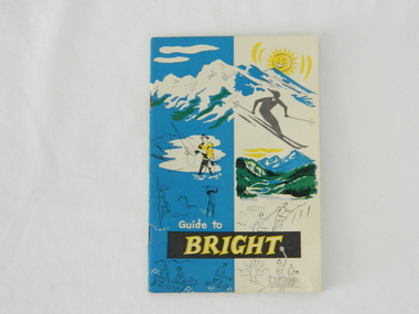 Kiewa Valley Historical Society
Pamphlet - Bright Tourism, Guide to Bright and District, late 1900s
This publication was produced in the early 1950s to provide the growing tourism trade (at this time), to the region with a more detailed overview of the facilities available to tourists of the region's attractions. This brochure is a very efficient and effective promotional publication. The increasing level of self promotion by local business and commerce sectors of the region the more sought after the region became and the greater the ability of the region to grow (non rural based economy). Some of the regions unique facilities and geological structures are well suited to those tourists who live in cities and "flat land" regional bush areas within Australia. This was a period when the average Australian domestic tourist was more able (finance and transport wise) to see more of their country within the short time they had for "holidays". In the late 1900s, however, with the increase to workers' recreational leave and better transportation (fares, ease of travel to overseas destinations) the local tourism numbers from other domestic locations have been steadily declining. From the 1970s onwards, the increased tourism demand from overseas tourists, for better facilities and easier access to these regional facilities, resulted in better transport, accommodation and communication, which has been a boon for all tourism within Australia. In the 21st century the world is becoming smaller and smaller for the international tourist, especially for those from crowded Asian cities. The greater attraction for "open" spaced locations such as this region are becoming a much sought after change of scenery. This pamphlet which targets the tourist, whether either from other Australian regions or the global tourist, is a good example of self promotion by a relatively small local population. This is especially significant because before the "tourist explosion" in the 1950s onward, these regional areas had a more introspective society with greater emphasis to locally established mores and values. The increased interactions with people from other areas and nations, combined with a greater global communication network is affecting those traditionally established mores to produce a some what unique social transformation which is constantly changing from one generation to the next. One important factor which tourism does bring is that it opens up the region to a wider range of people who look to the region for their own lifestyle changes.This pamphlet has a front cover in colour with the major activities in the region sketched depicting : sunshine, snow skiing, trout fishing, mountain climbing, golfing, swimming, alpine views, tennis, lawn bowls and picnics. The back cover is blank. The pamphlet is fastened together by two staples 30mm from top and bottom, and is folded with the cover slightly thicker than the fifteen pages. Thirteen pages have been printed on both sides. The first page has a black and white photograph of the hotel Alpine and the tall brick constructed Clock Tower. There are another five black and white photographs in the pamphlet.on front cover "Guide to BRIGHT"local tourism, regional information booklet, "time" related brochures, alpine local history -
 Eltham District Historical Society Inc
Photograph, Liz Pidgeon, Heritage Excursion; Maroondah Aqueduct, 3 September 2016, 3 September 2016
Newsletter No., 229, August 2016 Heritage Excursion - Maroondah Aqueduct Walk - Saturday 3rd September The Maroondah Aqueduct was once a major link in Melbourne’s water supply system. It was built between 1886 and 1891 to transfer water from the Watts River near Healesville to the Preston Reservoir. It was 66 km in length, made up of 41 km of open channel, 10 km of tunnel through hills and 15 km of pipeline across stream valleys known as inverted siphons. The section of the aqueduct through the Eltham area has been abandoned since the 1980s but the open channel has largely been retained. A recreational path follows the aqueduct reserve. For our excursion on 3rd September we intend to walk along the section of the aqueduct adjacent to Allendale Road. This is a section not visited on previous excursions and includes the transition from open channel to the inverted siphon across the Diamond Creek valley. Apart from the aqueduct itself the main feature of the walk is the extensive views across Eltham North and Diamond Creek. Along the way we will talk about the history of the aqueduct and the area. This easy walk is about 3 km return and will take 2 to 2.5 hours. It will start at 2pm at the junction of Allendale Road with Godber Road and Zig Zag Road North, officially Diamond Creek, but on the northern boundary of Eltham. (Melway ref.12 B10). Born Digitalmaroondah aqueduct, eltham north, activities, eltham district historical society, heritage excursion, acqueduct trail, sign -
 Eltham District Historical Society Inc
Photograph, Liz Pidgeon, Heritage Excursion; Maroondah Aqueduct, 3 September 2016, 3 September 2016
Newsletter No., 229, August 2016 Heritage Excursion - Maroondah Aqueduct Walk - Saturday 3rd September The Maroondah Aqueduct was once a major link in Melbourne’s water supply system. It was built between 1886 and 1891 to transfer water from the Watts River near Healesville to the Preston Reservoir. It was 66 km in length, made up of 41 km of open channel, 10 km of tunnel through hills and 15 km of pipeline across stream valleys known as inverted siphons. The section of the aqueduct through the Eltham area has been abandoned since the 1980s but the open channel has largely been retained. A recreational path follows the aqueduct reserve. For our excursion on 3rd September we intend to walk along the section of the aqueduct adjacent to Allendale Road. This is a section not visited on previous excursions and includes the transition from open channel to the inverted siphon across the Diamond Creek valley. Apart from the aqueduct itself the main feature of the walk is the extensive views across Eltham North and Diamond Creek. Along the way we will talk about the history of the aqueduct and the area. This easy walk is about 3 km return and will take 2 to 2.5 hours. It will start at 2pm at the junction of Allendale Road with Godber Road and Zig Zag Road North, officially Diamond Creek, but on the northern boundary of Eltham. (Melway ref.12 B10). Born Digitalmaroondah aqueduct, eltham north, activities, eltham district historical society, heritage excursion, acqueduct trail, diamond creek -
 Eltham District Historical Society Inc
Photograph, Liz Pidgeon, Heritage Excursion; Maroondah Aqueduct, 3 September 2016, 3 September 2016
Newsletter No., 229, August 2016 Heritage Excursion - Maroondah Aqueduct Walk - Saturday 3rd September The Maroondah Aqueduct was once a major link in Melbourne’s water supply system. It was built between 1886 and 1891 to transfer water from the Watts River near Healesville to the Preston Reservoir. It was 66 km in length, made up of 41 km of open channel, 10 km of tunnel through hills and 15 km of pipeline across stream valleys known as inverted siphons. The section of the aqueduct through the Eltham area has been abandoned since the 1980s but the open channel has largely been retained. A recreational path follows the aqueduct reserve. For our excursion on 3rd September we intend to walk along the section of the aqueduct adjacent to Allendale Road. This is a section not visited on previous excursions and includes the transition from open channel to the inverted siphon across the Diamond Creek valley. Apart from the aqueduct itself the main feature of the walk is the extensive views across Eltham North and Diamond Creek. Along the way we will talk about the history of the aqueduct and the area. This easy walk is about 3 km return and will take 2 to 2.5 hours. It will start at 2pm at the junction of Allendale Road with Godber Road and Zig Zag Road North, officially Diamond Creek, but on the northern boundary of Eltham. (Melway ref.12 B10). Born Digitalmaroondah aqueduct, eltham north, activities, eltham district historical society, heritage excursion, acqueduct trail, sign -
 Eltham District Historical Society Inc
Photograph, Liz Pidgeon, Heritage Excursion; Maroondah Aqueduct, 3 September 2016, 3 September 2016
Newsletter No., 229, August 2016 Heritage Excursion - Maroondah Aqueduct Walk - Saturday 3rd September The Maroondah Aqueduct was once a major link in Melbourne’s water supply system. It was built between 1886 and 1891 to transfer water from the Watts River near Healesville to the Preston Reservoir. It was 66 km in length, made up of 41 km of open channel, 10 km of tunnel through hills and 15 km of pipeline across stream valleys known as inverted siphons. The section of the aqueduct through the Eltham area has been abandoned since the 1980s but the open channel has largely been retained. A recreational path follows the aqueduct reserve. For our excursion on 3rd September we intend to walk along the section of the aqueduct adjacent to Allendale Road. This is a section not visited on previous excursions and includes the transition from open channel to the inverted siphon across the Diamond Creek valley. Apart from the aqueduct itself the main feature of the walk is the extensive views across Eltham North and Diamond Creek. Along the way we will talk about the history of the aqueduct and the area. This easy walk is about 3 km return and will take 2 to 2.5 hours. It will start at 2pm at the junction of Allendale Road with Godber Road and Zig Zag Road North, officially Diamond Creek, but on the northern boundary of Eltham. (Melway ref.12 B10). Born Digitalmaroondah aqueduct, eltham north, activities, eltham district historical society, heritage excursion, acqueduct trail -
 Eltham District Historical Society Inc
Photograph, Liz Pidgeon, Heritage Excursion; Maroondah Aqueduct, 3 September 2016, 3 September 2016
Intersection with local Street signs Newsletter No., 229, August 2016 Heritage Excursion - Maroondah Aqueduct Walk - Saturday 3rd September The Maroondah Aqueduct was once a major link in Melbourne’s water supply system. It was built between 1886 and 1891 to transfer water from the Watts River near Healesville to the Preston Reservoir. It was 66 km in length, made up of 41 km of open channel, 10 km of tunnel through hills and 15 km of pipeline across stream valleys known as inverted siphons. The section of the aqueduct through the Eltham area has been abandoned since the 1980s but the open channel has largely been retained. A recreational path follows the aqueduct reserve. For our excursion on 3rd September we intend to walk along the section of the aqueduct adjacent to Allendale Road. This is a section not visited on previous excursions and includes the transition from open channel to the inverted siphon across the Diamond Creek valley. Apart from the aqueduct itself the main feature of the walk is the extensive views across Eltham North and Diamond Creek. Along the way we will talk about the history of the aqueduct and the area. This easy walk is about 3 km return and will take 2 to 2.5 hours. It will start at 2pm at the junction of Allendale Road with Godber Road and Zig Zag Road North, officially Diamond Creek, but on the northern boundary of Eltham. (Melway ref.12 B10). Born Digitalmaroondah aqueduct, eltham north, activities, eltham district historical society, heritage excursion, street signs, acqueduct trail, allendale rd, godber rd, zig zag road, intersection -
 Eltham District Historical Society Inc
Photograph, Liz Pidgeon, Heritage Excursion; Maroondah Aqueduct, 3 September 2016, 3 September 2016
Newsletter No., 229, August 2016 Heritage Excursion - Maroondah Aqueduct Walk - Saturday 3rd September The Maroondah Aqueduct was once a major link in Melbourne’s water supply system. It was built between 1886 and 1891 to transfer water from the Watts River near Healesville to the Preston Reservoir. It was 66 km in length, made up of 41 km of open channel, 10 km of tunnel through hills and 15 km of pipeline across stream valleys known as inverted siphons. The section of the aqueduct through the Eltham area has been abandoned since the 1980s but the open channel has largely been retained. A recreational path follows the aqueduct reserve. For our excursion on 3rd September we intend to walk along the section of the aqueduct adjacent to Allendale Road. This is a section not visited on previous excursions and includes the transition from open channel to the inverted siphon across the Diamond Creek valley. Apart from the aqueduct itself the main feature of the walk is the extensive views across Eltham North and Diamond Creek. Along the way we will talk about the history of the aqueduct and the area. This easy walk is about 3 km return and will take 2 to 2.5 hours. It will start at 2pm at the junction of Allendale Road with Godber Road and Zig Zag Road North, officially Diamond Creek, but on the northern boundary of Eltham. (Melway ref.12 B10). Born Digitalmaroondah aqueduct, eltham north, activities, eltham district historical society, heritage excursion, acqueduct trail -
 Eltham District Historical Society Inc
Photograph, Liz Pidgeon, Heritage Excursion; Maroondah Aqueduct, 3 September 2016, 3 September 2016
Property related to Yarra Valley Water, Diamond Creek Newsletter No., 229, August 2016 Heritage Excursion - Maroondah Aqueduct Walk - Saturday 3rd September The Maroondah Aqueduct was once a major link in Melbourne’s water supply system. It was built between 1886 and 1891 to transfer water from the Watts River near Healesville to the Preston Reservoir. It was 66 km in length, made up of 41 km of open channel, 10 km of tunnel through hills and 15 km of pipeline across stream valleys known as inverted siphons. The section of the aqueduct through the Eltham area has been abandoned since the 1980s but the open channel has largely been retained. A recreational path follows the aqueduct reserve. For our excursion on 3rd September we intend to walk along the section of the aqueduct adjacent to Allendale Road. This is a section not visited on previous excursions and includes the transition from open channel to the inverted siphon across the Diamond Creek valley. Apart from the aqueduct itself the main feature of the walk is the extensive views across Eltham North and Diamond Creek. Along the way we will talk about the history of the aqueduct and the area. This easy walk is about 3 km return and will take 2 to 2.5 hours. It will start at 2pm at the junction of Allendale Road with Godber Road and Zig Zag Road North, officially Diamond Creek, but on the northern boundary of Eltham. (Melway ref.12 B10). Born Digitalmaroondah aqueduct, eltham north, activities, eltham district historical society, heritage excursion, yarra valley water, diamond creek -
 Eltham District Historical Society Inc
Photograph, Liz Pidgeon, Heritage Excursion; Maroondah Aqueduct, 3 September 2016, 3 September 2016
Sign for Yarra Valley Water at Diamond Creek property Newsletter No., 229, August 2016 Heritage Excursion - Maroondah Aqueduct Walk - Saturday 3rd September The Maroondah Aqueduct was once a major link in Melbourne’s water supply system. It was built between 1886 and 1891 to transfer water from the Watts River near Healesville to the Preston Reservoir. It was 66 km in length, made up of 41 km of open channel, 10 km of tunnel through hills and 15 km of pipeline across stream valleys known as inverted siphons. The section of the aqueduct through the Eltham area has been abandoned since the 1980s but the open channel has largely been retained. A recreational path follows the aqueduct reserve. For our excursion on 3rd September we intend to walk along the section of the aqueduct adjacent to Allendale Road. This is a section not visited on previous excursions and includes the transition from open channel to the inverted siphon across the Diamond Creek valley. Apart from the aqueduct itself the main feature of the walk is the extensive views across Eltham North and Diamond Creek. Along the way we will talk about the history of the aqueduct and the area. This easy walk is about 3 km return and will take 2 to 2.5 hours. It will start at 2pm at the junction of Allendale Road with Godber Road and Zig Zag Road North, officially Diamond Creek, but on the northern boundary of Eltham. (Melway ref.12 B10). Born Digitalmaroondah aqueduct, eltham north, activities, eltham district historical society, heritage excursion, diamond creek, yarra valley water, sign -
 Eltham District Historical Society Inc
Photograph, Liz Pidgeon, Heritage Excursion; Maroondah Aqueduct, 3 September 2016, 3 September 2016
Newsletter No., 229, August 2016 Heritage Excursion - Maroondah Aqueduct Walk - Saturday 3rd September The Maroondah Aqueduct was once a major link in Melbourne’s water supply system. It was built between 1886 and 1891 to transfer water from the Watts River near Healesville to the Preston Reservoir. It was 66 km in length, made up of 41 km of open channel, 10 km of tunnel through hills and 15 km of pipeline across stream valleys known as inverted siphons. The section of the aqueduct through the Eltham area has been abandoned since the 1980s but the open channel has largely been retained. A recreational path follows the aqueduct reserve. For our excursion on 3rd September we intend to walk along the section of the aqueduct adjacent to Allendale Road. This is a section not visited on previous excursions and includes the transition from open channel to the inverted siphon across the Diamond Creek valley. Apart from the aqueduct itself the main feature of the walk is the extensive views across Eltham North and Diamond Creek. Along the way we will talk about the history of the aqueduct and the area. This easy walk is about 3 km return and will take 2 to 2.5 hours. It will start at 2pm at the junction of Allendale Road with Godber Road and Zig Zag Road North, officially Diamond Creek, but on the northern boundary of Eltham. (Melway ref.12 B10). Born Digitalmaroondah aqueduct, eltham north, activities, eltham district historical society, heritage excursion, acqueduct trail -
 Eltham District Historical Society Inc
Photograph, Liz Pidgeon, Heritage Excursion; Maroondah Aqueduct, 3 September 2016, 3 September 2016
View of Diamond Creek Newsletter No., 229, August 2016 Heritage Excursion - Maroondah Aqueduct Walk - Saturday 3rd September The Maroondah Aqueduct was once a major link in Melbourne’s water supply system. It was built between 1886 and 1891 to transfer water from the Watts River near Healesville to the Preston Reservoir. It was 66 km in length, made up of 41 km of open channel, 10 km of tunnel through hills and 15 km of pipeline across stream valleys known as inverted siphons. The section of the aqueduct through the Eltham area has been abandoned since the 1980s but the open channel has largely been retained. A recreational path follows the aqueduct reserve. For our excursion on 3rd September we intend to walk along the section of the aqueduct adjacent to Allendale Road. This is a section not visited on previous excursions and includes the transition from open channel to the inverted siphon across the Diamond Creek valley. Apart from the aqueduct itself the main feature of the walk is the extensive views across Eltham North and Diamond Creek. Along the way we will talk about the history of the aqueduct and the area. This easy walk is about 3 km return and will take 2 to 2.5 hours. It will start at 2pm at the junction of Allendale Road with Godber Road and Zig Zag Road North, officially Diamond Creek, but on the northern boundary of Eltham. (Melway ref.12 B10). Born Digitalmaroondah aqueduct, eltham north, activities, eltham district historical society, heritage excursion, diamond creek, acqueduct trail -
 Eltham District Historical Society Inc
Photograph, Liz Pidgeon, Heritage Excursion; Maroondah Aqueduct, 3 September 2016, 3 September 2016
Russell Yeomann provides historical information on the heritage excursion From the Newsletter No., 229, August 2016 Heritage Excursion - Maroondah Aqueduct Walk - Saturday 3rd September The Maroondah Aqueduct was once a major link in Melbourne’s water supply system. It was built between 1886 and 1891 to transfer water from the Watts River near Healesville to the Preston Reservoir. It was 66 km in length, made up of 41 km of open channel, 10 km of tunnel through hills and 15 km of pipeline across stream valleys known as inverted siphons. The section of the aqueduct through the Eltham area has been abandoned since the 1980s but the open channel has largely been retained. A recreational path follows the aqueduct reserve. For our excursion on 3rd September we intend to walk along the section of the aqueduct adjacent to Allendale Road. This is a section not visited on previous excursions and includes the transition from open channel to the inverted siphon across the Diamond Creek valley. Apart from the aqueduct itself the main feature of the walk is the extensive views across Eltham North and Diamond Creek. Along the way we will talk about the history of the aqueduct and the area. This easy walk is about 3 km return and will take 2 to 2.5 hours. It will start at 2pm at the junction of Allendale Road with Godber Road and Zig Zag Road North, officially Diamond Creek, but on the northern boundary of Eltham. (Melway ref.12 B10). Born Digitalmaroondah aqueduct, eltham north, activities, eltham district historical society, heritage excursion, russell yeoman, aqueduct trail -
 Eltham District Historical Society Inc
Photograph, Liz Pidgeon, Heritage Excursion; Maroondah Aqueduct, 3 September 2016, 3 September 2016
Newsletter No., 229, August 2016 Heritage Excursion - Maroondah Aqueduct Walk - Saturday 3rd September The Maroondah Aqueduct was once a major link in Melbourne’s water supply system. It was built between 1886 and 1891 to transfer water from the Watts River near Healesville to the Preston Reservoir. It was 66 km in length, made up of 41 km of open channel, 10 km of tunnel through hills and 15 km of pipeline across stream valleys known as inverted siphons. The section of the aqueduct through the Eltham area has been abandoned since the 1980s but the open channel has largely been retained. A recreational path follows the aqueduct reserve. For our excursion on 3rd September we intend to walk along the section of the aqueduct adjacent to Allendale Road. This is a section not visited on previous excursions and includes the transition from open channel to the inverted siphon across the Diamond Creek valley. Apart from the aqueduct itself the main feature of the walk is the extensive views across Eltham North and Diamond Creek. Along the way we will talk about the history of the aqueduct and the area. This easy walk is about 3 km return and will take 2 to 2.5 hours. It will start at 2pm at the junction of Allendale Road with Godber Road and Zig Zag Road North, officially Diamond Creek, but on the northern boundary of Eltham. (Melway ref.12 B10). Born Digitalmaroondah aqueduct, eltham north, activities, eltham district historical society, heritage excursion, water-pipes, pipes, cattle yard, aqueduct trail -
 Eltham District Historical Society Inc
Photograph, Liz Pidgeon, Heritage Excursion; Maroondah Aqueduct, 3 September 2016, 3 September 2016
Newsletter No., 229, August 2016 Heritage Excursion - Maroondah Aqueduct Walk - Saturday 3rd September The Maroondah Aqueduct was once a major link in Melbourne’s water supply system. It was built between 1886 and 1891 to transfer water from the Watts River near Healesville to the Preston Reservoir. It was 66 km in length, made up of 41 km of open channel, 10 km of tunnel through hills and 15 km of pipeline across stream valleys known as inverted siphons. The section of the aqueduct through the Eltham area has been abandoned since the 1980s but the open channel has largely been retained. A recreational path follows the aqueduct reserve. For our excursion on 3rd September we intend to walk along the section of the aqueduct adjacent to Allendale Road. This is a section not visited on previous excursions and includes the transition from open channel to the inverted siphon across the Diamond Creek valley. Apart from the aqueduct itself the main feature of the walk is the extensive views across Eltham North and Diamond Creek. Along the way we will talk about the history of the aqueduct and the area. This easy walk is about 3 km return and will take 2 to 2.5 hours. It will start at 2pm at the junction of Allendale Road with Godber Road and Zig Zag Road North, officially Diamond Creek, but on the northern boundary of Eltham. (Melway ref.12 B10). Born Digitalmaroondah aqueduct, eltham north, activities, eltham district historical society, heritage excursion, aqueduct trail, cattle yard -
 Eltham District Historical Society Inc
Photograph, Liz Pidgeon, Heritage Excursion; Maroondah Aqueduct, 3 September 2016, 3 September 2016
Newsletter No., 229, August 2016 Heritage Excursion - Maroondah Aqueduct Walk - Saturday 3rd September The Maroondah Aqueduct was once a major link in Melbourne’s water supply system. It was built between 1886 and 1891 to transfer water from the Watts River near Healesville to the Preston Reservoir. It was 66 km in length, made up of 41 km of open channel, 10 km of tunnel through hills and 15 km of pipeline across stream valleys known as inverted siphons. The section of the aqueduct through the Eltham area has been abandoned since the 1980s but the open channel has largely been retained. A recreational path follows the aqueduct reserve. For our excursion on 3rd September we intend to walk along the section of the aqueduct adjacent to Allendale Road. This is a section not visited on previous excursions and includes the transition from open channel to the inverted siphon across the Diamond Creek valley. Apart from the aqueduct itself the main feature of the walk is the extensive views across Eltham North and Diamond Creek. Along the way we will talk about the history of the aqueduct and the area. This easy walk is about 3 km return and will take 2 to 2.5 hours. It will start at 2pm at the junction of Allendale Road with Godber Road and Zig Zag Road North, officially Diamond Creek, but on the northern boundary of Eltham. (Melway ref.12 B10). Born Digitalmaroondah aqueduct, eltham north, activities, eltham district historical society, heritage excursion, aqueduct trail, water-pipe, pipe -
 Eltham District Historical Society Inc
Photograph, Liz Pidgeon, Heritage Excursion; Maroondah Aqueduct, 3 September 2016, 3 September 2016
Newsletter No., 229, August 2016 Heritage Excursion - Maroondah Aqueduct Walk - Saturday 3rd September The Maroondah Aqueduct was once a major link in Melbourne’s water supply system. It was built between 1886 and 1891 to transfer water from the Watts River near Healesville to the Preston Reservoir. It was 66 km in length, made up of 41 km of open channel, 10 km of tunnel through hills and 15 km of pipeline across stream valleys known as inverted siphons. The section of the aqueduct through the Eltham area has been abandoned since the 1980s but the open channel has largely been retained. A recreational path follows the aqueduct reserve. For our excursion on 3rd September we intend to walk along the section of the aqueduct adjacent to Allendale Road. This is a section not visited on previous excursions and includes the transition from open channel to the inverted siphon across the Diamond Creek valley. Apart from the aqueduct itself the main feature of the walk is the extensive views across Eltham North and Diamond Creek. Along the way we will talk about the history of the aqueduct and the area. This easy walk is about 3 km return and will take 2 to 2.5 hours. It will start at 2pm at the junction of Allendale Road with Godber Road and Zig Zag Road North, officially Diamond Creek, but on the northern boundary of Eltham. (Melway ref.12 B10). Born Digitalmaroondah aqueduct, eltham north, activities, eltham district historical society, heritage excursion, aqueduct trail, cattle yards