Showing 945 items matching "reservoir"
-
 Linton and District Historical Society Inc
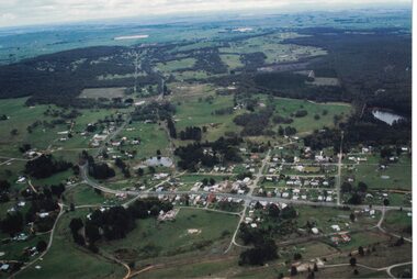
Photograph, Photographer: Alan Giles, Aerial View, Sussex Street, Linton, 1991, 1.9.1991
Aerial view of Linton, Sussex St (Glenelg Highway) running from RH bottom corner, Mortchup Road reservoir centre RH side."Linton Township, Vic-1st September 1991".linton township, sussex street linton -
 Tatura Irrigation & Wartime Camps Museum
Book, Irrigation and Water Supply Development in Victoria, 1954
History of irrigaton in Victoria. Reference to Eildon Reservoir, Goulburn Weir, Waranga Reservoir, River Murray irrigation systemsBuff and blue covered book, showing farmhouse, dairy cattle on front cover, cattle, trees and channel on backirrigation, water supply, goulburn river, books, history, local -
 Maldon Vintage Machinery Museum Inc
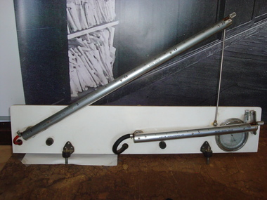
Air Flow Guage, Estimated pre 1970
Comprises two calibrated cylinders mounted on a board for measuring inches of water. Gauges measure air velocity. Cylinders are of steel with calibrations on aluminium casings. Flexible tubes are connected to reservoirs at the back of the mounting board, one black rubber the other red plastic. A reference barometer is mounted at the bottom right hand corner of the backing board. Reservoirs at the rear are of metal, coloured blue.instruments, air flow -
 Orbost & District Historical Society
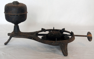
stove/burner, C 1905
A black camp stove, single burner, which uses alcohol fuel. It is made of iron and has a steel reservoir for the fuel. There is a wooden handle for fuel control. Embossed on centre of burner: ”Brilliant / D.R. Patent”.stove burner fuel-stove cooking food-preparation -
 Orbost & District Historical Society
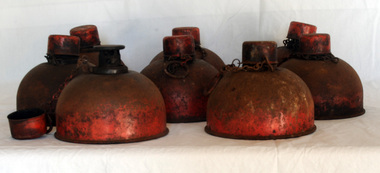
road flares, First half 20th century
These flares were possibly used during WW11. They were used by Orbost Aero Club at Marlo from 1964 onwards for transporting patients by aerial ambulance to Melbourne. They were placed on the L.H.S. of the runway to indicate wind direction. They were superseded in the late 1970's by pilot activated lighting (PAL) switched on by incoming pilots via radio.These lamps are associated with the history of the Orbost Aero Club.Eight kerosene smudge pot road flares - round metal bases painted red. There is a reservoir at the bottom used for kerosene storage. It was lit at the top for flare.DIETZ . 51 Use Kerosene only Made in U.S.A.lighting kerosene-flares road-flares beacons marlo-airport -
 Orbost & District Historical Society
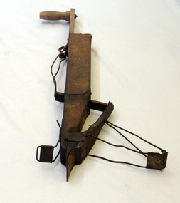
maize planter, 1900 - 1910
A hand-operated maize planted used in the maize industry, possibly used prior tothe introduction of larger horse-drawn planters which could plant two rows at a time. Associated with the large maize growing industry in the Orbost region 1880s - 1950s.A metal and wooden maize planter, a square seed reservoir, wooden handle on the top, a swing door at the bottom which is manouvered by two wires connected to the door.maize-corn-planter agricultural-implement -
 Bendigo Historical Society Inc.
Document - BENDIGO'S WATER SUPPLY
Handwritten notes titled 'Bendigo's Water Supply'. Notes mention the early water supply for Bendigo, The construction of the reservoirs, some costs, and the dates they were constructed.document, bendigo's water supply, e h emmett, bendigo water works co, no 7 reservoir, law courts, coliban scheme, j f sullivan, the bendigo council, water works, robinson crusoe gully, angus mackay, state rivers and water supply commission, lauriston reservoir, lake eppalock, dates when reservoirs were built, preston vale, bendigo and vicinity -
 Linton and District Historical Society Inc
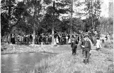
Photograph, Postcard : group of people on bushland outing, c.1911
Postcard given to Stella Todd by Linton State School head teacher Mr H. B. Williamson, wishing her a happy year in 1912.Black and white postcard photograph of men, women and children, thought to be a Linton State School group, on an outing in rural setting (possibly Mortchup Road reservoir)."To Stella Todd with best wishes for the new year 1912 from her teacher H B Williamson".stella todd, stella surman, linton state school no. 880, h. b. williamson [head teacher], picnics -
 Eltham District Historical Society Inc
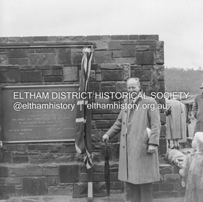
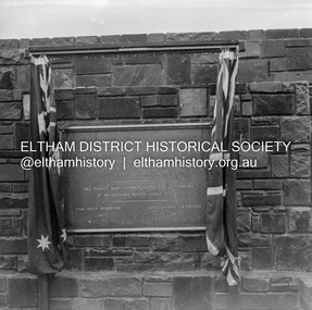
Negative - Photograph, J.A. McDonald, Upper Yarra Dam, 26 Nov. 1957
Sir Dallas Brooks following the formal opening of the Upper Yarra Reservoir, 26 November 1957 Upper Yarra Reservoir Opened by His Excellency The Governor of Victoria General Sir Dallas Brooks K.C.B.., K.C.M.G., K.C.V.O., D.S.O., K.St.J. On 26th November, 1957 This tablet also commemortyaes the centenary Of Melbourne's water supply system Yan Yean Reservoir 1857 Upper Yarra Reservoir 1957Record of various Shire of Eltham infrastructure works undertaken during the period of 1952-1962 involving bridge and road reconstruction projects, sometimes with Eltham Shire Council Project Reference numbers quoted. It was during this period that a number of significant improvements were made to roads and new bridges constructed within the shire that remain in place as of present day (2022). In many situations, the photos provide a tangible visible record of infrastructure that existed throughout the early days of the Shire. The album was put together by or under the direction of the Shire Engineer, J.A. McDonald.infrastructure, shire of eltham, 1957-11-26, opening ceremony, plaques, sir dallas brooks, upper yarra dam, upper yarra reservoir -
 Ballaarat Mechanics' Institute (BMI Ballarat)
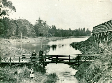
Reservoir Water Course
ballarat, reservoir, people -
 Ballaarat Mechanics' Institute (BMI Ballarat)
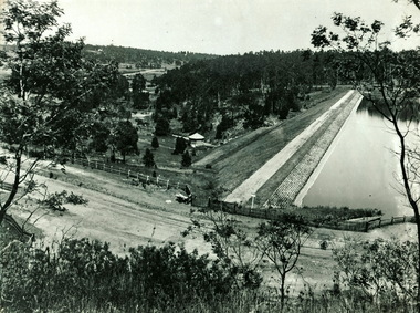
Gong Gong Reservoir
This photograph is from the Max Harris Collection held by the Ballaraat Mechanics' Institute. Please contact BMI for all print and usage inquiries.ballarat, gong gong, reservoir -
 Ballaarat Mechanics' Institute (BMI Ballarat)
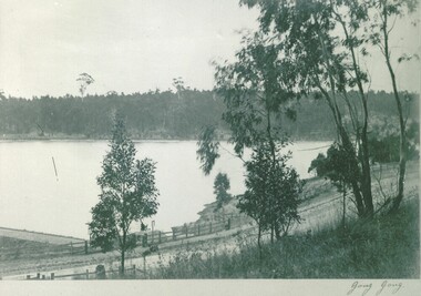
Gong Gong Reservoir
This photograph is from the Max Harris Collection held by the Ballaraat Mechanics' Institute. Please contact BMI for all print and usage inquiries.ballarat, gong gong, reservoir -
 Uniting Church Archives - Synod of Victoria
Booklet - Methdodist Girls' Comardeship Rays Section, General Grand Council of the Methodist Girls' Comradeship, Senior Ritual, 1966
Table of Contents: Comradeship hymn; diagram for seating at meeting; Ritual for the meeting; Initiation of Chief Ray or Deputy Chief Ray; Initiation; Installation Ceremony; Graduation Service.MGC044.1 and MGC044.2 - Gold soft covered 12 page booklet with black text. The cover shows the badge of the Methodist Girls' Comradeship.non-fictionTable of Contents: Comradeship hymn; diagram for seating at meeting; Ritual for the meeting; Initiation of Chief Ray or Deputy Chief Ray; Initiation; Installation Ceremony; Graduation Service.methodist girls' comradship rays section, handbooks, methodist church of australasia, reservoir methodist girls' rays pansy branch 292", jan woolhouse -
 Wodonga & District Historical Society Inc
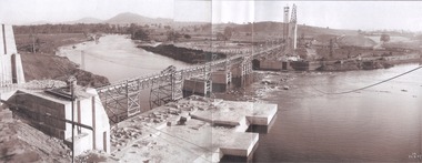
Album - Hume Reservoir Australia Album - General View of Works from New South Wales end, Looking Upstream, August 1927
This set of photos is from a leather bound album bearing the inscription "HUME RESERVOIR AUSTRALIA" plus 'The Rt. Hon. L. C. M. S. Amery, P. C., M .P.' all inscribed in gold. It was presented to The Rt. Hon. L. C. M. S. Amery, P. C., M. P, Secretary of State for Dominion Affairs on the occasion of his visit to the Hume Reservoir on 2nd November 1927. This album is of local and national significance as it documents the planning and development of the Hume Reservoir up to 1927. It was the largest water reservoir in the British Empire. The album records the pioneering engineering work that went into its construction.DEPARTMENT OF PUBLIC WORKS, N.S.W. RIVER MURRAY WATERS SCHEME. HUME RESERVOIR. 22. General View of Works from New South Wales end, Looking Upstream. Features: At the left, part of the North Wing Wall, the highest part of which is 26 feet below its ultimate height. Below in the foreground is the portion of the dam where provision is to be made for hydro-electric generation. The tubes, three in number, 13 feet in diameter, will be laid on the level shown and an early start will be made in laying them. The level for the other four regulating outlets, 9 feet in diameter, together with a part of the spillway section of the dam, is underwater at this stage and it may be remarked that at one point, about half way across the channel where the water is now flowing, the concrete foundations are about 80 feet below the level of the water. The broken surface of the water is due to the large “plums” in the concrete. The still water in the right foreground is the stilling pool over the concrete floor of which there is now more than 20 feet of water and by means of which the discharge from the outlet pipes will be quelled. The trestlework on the upstream side of the dam carries the concrete belt conveyor. It extends from the concrete mixer house, which is out of the picture, behind the wing wall, along almost the entire length of the concrete portion of the dam. The concrete is discharged from the belt at any desired point by means of trippers, one of which may be seen over the second trestle. On the other side of the flowing water is the coffer dam. A channel 300 feet wide involving about 140,000 cubic yards of excavation and dug for the temporary diversion of the river as it is flowing now. To the right top of the view beyond the Coffer Dam is the earth embankment being thrown across the major part of the valley by the Victorian Constructing Authority. The Mitta Mitta River flows into the Murray at the far end of the reach of water on the left. August 1927.hume reservoir australia, river murray waters scheme, hume reservoir construction -
Glenelg Shire Council Cultural Collection
Functional object - Whale Oil Lamp, n.d
Brass whale oil lamp, removable reservoir, lid with knob on top. Two burners, opposite each other with drip trays and a fold down carry handle. -
Port Melbourne Historical & Preservation Society
Photograph - Queen Elizabeth II and Duke of Edinburgh in Melbourne, 1954
Photograph Queen Elizabeth II and Duke of Edinburgh in Melbourne during the Royal Tour of Australia 1953-54:taken at O'Shannessey Reservoir Chalet just past Warburtonlocal government - city of port melbourne, royal visits and occasions, queen elizabeth ii, duke of edinburgh -
Tatura Irrigation & Wartime Camps Museum
Photograph, Big Eildon Project, 1954
Taken by photographer for State Rivers and Water Supply Commission.Large sepia photograph. Terraced earthen bank forming wall of reservoir main feature - trees and several telegraph poles in foreground - gently rounded hills on horizon.Below photo: "BIG EILDON PROJECT / MAIN BANK FROM OBSERVATION POINT."victoria state rivers and water supply commission, eildon, eildon dam -
Tatura Irrigation & Wartime Camps Museum
Photograph, 19/12/1946
Taken by photographer for State Rivers and Water Supply Commission.Medium sized black and white photograph. Waranga reservoir - rubble spray wall - 2'0" high - centre foreground - rail lines and trees on right mid picturegoulburn weir, victorian state rivers and supply commission -
 Southern Sherbrooke Historical Society Inc.
Mitchell's Fly spray pump
Long cylinder with retractable handle/plunger, attached to a cylindrical reservoir with screw-on lid. Paper label says "Mitchells The Brush People". Used to dispense aerosol spray.mitchells -
 Kew Historical Society Inc
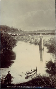
Postcard, River Yarra near Macauleys' Boathouse Kew, c.1910
The Pipe Bridge was constructed to bring fresh water from Fairfield to Kew. This bridge was destroyed in the 1934 Flood and later reconstructed.Early sepia real photo postcard of the first Pipe Bridge bringing water from the Yan Yean Reservoir to Kew. The site is upriver of the original Macauley's boathouse. Obverse: "River Yarra near Macauleys' Boat House Kew". Reverse: "(Pipe Water Line) / Kew to Fairfield above boat house / Pipe Bridge / Received from L. Bennett 1980".bridges - kew (vic.), bridges - yarra river -- kew (vic.), pipe bridge -
 Linton and District Historical Society Inc
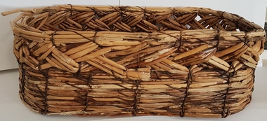
Basket, Reed Basket, Linton
Rectangular woven basket hand-made at Linton during the Great Depression (1930s). Reeds used to make it came from the old Linton Reservoir on Mortchup Road.baskets, handcrafts, great depression 1930s -
 Eltham District Historical Society Inc
Negative - Photograph, J.A. McDonald, Upper Yarra Dam, 26 Nov. 1957
Upper Yarra Reservoir Opened by His Excellency The Governor of Victoria General Sir Dallas Brooks K.C.B.., K.C.M.G., K.C.V.O., D.S.O., K.St.J. On 26th November, 1957 This tablet also commemortyaes the centenary Of Melbourne's water supply system Yan Yean Reservoir 1857 Upper Yarra Reservoir 1957Record of various Shire of Eltham infrastructure works undertaken during the period of 1952-1962 involving bridge and road reconstruction projects, sometimes with Eltham Shire Council Project Reference numbers quoted. It was during this period that a number of significant improvements were made to roads and new bridges constructed within the shire that remain in place as of present day (2022). In many situations, the photos provide a tangible visible record of infrastructure that existed throughout the early days of the Shire. The album was put together by or under the direction of the Shire Engineer, J.A. McDonald.infrastructure, shire of eltham, 1957-11-26, opening ceremony, plaques, sir dallas brooks, upper yarra dam, upper yarra reservoir -
 Eltham District Historical Society Inc
Negative - Photograph, J.A. McDonald, Upper Yarra Dam, 26 Nov. 1957
Upper Yarra Reservoir Opened by His Excellency The Governor of Victoria General Sir Dallas Brooks K.C.B.., K.C.M.G., K.C.V.O., D.S.O., K.St.J. On 26th November, 1957 This tablet also commemortyaes the centenary Of Melbourne's water supply system Yan Yean Reservoir 1857 Upper Yarra Reservoir 1957Record of various Shire of Eltham infrastructure works undertaken during the period of 1952-1962 involving bridge and road reconstruction projects, sometimes with Eltham Shire Council Project Reference numbers quoted. It was during this period that a number of significant improvements were made to roads and new bridges constructed within the shire that remain in place as of present day (2022). In many situations, the photos provide a tangible visible record of infrastructure that existed throughout the early days of the Shire. The album was put together by or under the direction of the Shire Engineer, J.A. McDonald.infrastructure, shire of eltham, 1957-11-26, opening ceremony, plaques, upper yarra dam, upper yarra reservoir -
 Greensborough Historical Society
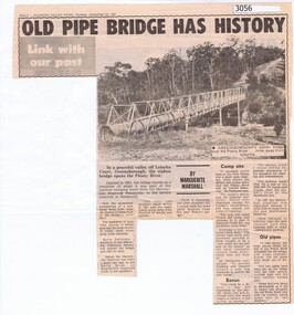
Newspaper Clipping, Diamond Valley News, Old pipe bridge has history, by Marguerite Marshall, 1891o
The aqueduct siphon bridge over the Plenty River, opened in 1891, was part of the pipeline bringing water from the service reservoir at Healesville, prior to the construction of the Maroondah Reservoir.News article, black and white text and photograph.aqueduct pipe bridge greensborough -
 Melbourne Water
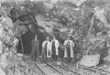
Photograph - Tunnel at the O'Shannasy Dam, 9th April 1921
The O'Shannassy Reservoir supplies water to the Silvan Reservoir, which distributes it to most parts of Melbourne. The dam was completed in 1928 and is an earthfill embankment with a reinforced concrete core wall.This photograph is significant as it provides a detailed insight into the Boards activity and construction of one of Melbourne's most important water supply systems. Furthermore, it is of historical importance to the history of Melbourne while it is representative of shaping Melbourne's environments, transforming and managing land and natural resources, and providing urban infrastructure and services. This photograph also covers the theme of Safety, depicting the safety standards of the time particularly with clothing. Black and white photographmmbw, melbourne metropolitan board of works, melbourne water, silvan reservoir, o'shannassy reservoir, construction, work, men, infrastructure -
 Marysville & District Historical Society
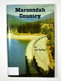
Book, Maroondah Country, 1979
A history of the Maroondah ReservoirPaperback. Front cover shows a colour photograph of the Maroondah Dam wall. Back cover shows a black and white photograph of the Maroondah Dam under construction.Madge Stevens / 85 Rose Street / West Coburg From Mena & Bill on / birthday 5.9.82 AN APPRECIATION Living all my earlier life at my birth-place, Heales-/ ville, with my sisters and brothers and our good parents,/ it was a privilege to return and re-acquaint during the/ collecting of these few impressions of the old times./ Thanks are due to the obliging attendants at MMBW/ and LaTrobe libraries, where frequent checks of old/ newspapers - including "The Healesville & Yarra Glen/ Guardian" - and records were essential./ Thanks also to my friends, and cousin Dave./ Ann Thomas Stamp of Marysville & District / Historical Society Inc / P.O. Box 22 / Marysville 3779maroondah dam, maroondah, fernshawe, healesville, maroondah aqueduct, maroondah reservoir, victoria, history -
 Halls Gap & Grampians Historical Society
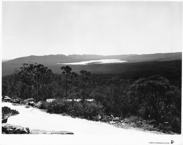
Photograph - B/W, C 1960s (?)
This photo is a view from the road at Reed's Lookout.The photo shows the view from beside a road (the road at Reed's Lookout), across bushland to a large reservoir (Lake Wartook). There is a range of peaks in the background. The road forms the foreground.'Forests Commission, Victoria' inscribed on bottom, right of border. 'Publicity & Public relations Branch, When reproducing please Acknowledge Forests Commission, Victoria, Negative No. 322-34' stamped on back.scenery, lookouts -
 Southern Sherbrooke Historical Society Inc.
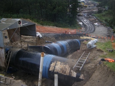
Photograph - Cardinia Reservoir works in conjunction with Wonthaggi Desalination Plant
Set of five colour photos showing preparations at Cardinia Reservoir, Narre Warren East, to allow for water to be pumped up from the Wonthaggi Desalination plant in November 2010. -
 City of Kingston
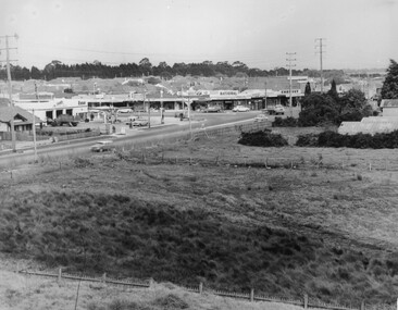
Photograph - Black and white, c. 1963
This image depicts the intersection of increasing urbanisation and the rural landscape that once made up the area now known as City of Kingston.Black and white photograph of the intersection of Warrigal Road and Centre Road, South Oakleigh, viewed from the reservoir. In the foreground are paddocks and in the background is a shopping strip, including a petrol station.Handwritten in blue ink on reverse: 2196 Handwritten in red ink on reverse: 100%oakleigh, roads, shopping strip, paddocks -
Bendigo Historical Society Inc.
Map - HARCOURT : COUNTY OF BENDIGO, December 1951
Map. Harcourt, County of Bendigo, County of Talbot, Town of Harcourt, Walmer, Sutton Grange, Ravenswood, Victorian Water Supply Reservoir, in connection with Barkers Creek Reservoir, Barkers Creek, Calder Highway, Northern Railway, Axe Creek. By authority J.J. Gourley, Government Printer, Melbourne. Drawn and reproduced at the Department of Lands and Survey, Melbourne. December 1951. Price 5/- per sheet. (number 100 in map cupboard 1)J.J. Gourley, Government Printer, Melbourne.map, bendigo, harcourt