Showing 6781 items matching "river"
-
 Marysville & District Historical Society
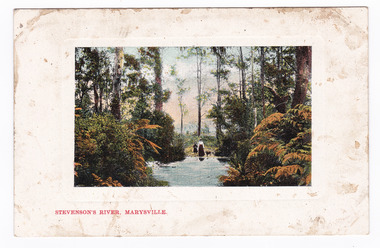
Postcard (item) - Colour postcard, Nicholas John Caire, Stevenson's River, Marysville, 1858-1918
One of a series of postcards of photographs taken by socialite photographer Nicholas John Caire.One of a series of postcards of photographs taken by socialite photographer Nicholas John Caire. N.J. Caire had a great love for the area and in the late 1800's took many photographs of Marysville and its surrounds.POST CARD. THIS SPACE FOR CORRESPONDENCE THE ADDRESS ONLY HERE PLACE/ POSTAGE/ STAMP/ HERE.steavenson river, stevenson's river, nicholas john caire, marysville, victoria, postcard, souvenir -
 Ballarat Heritage Services
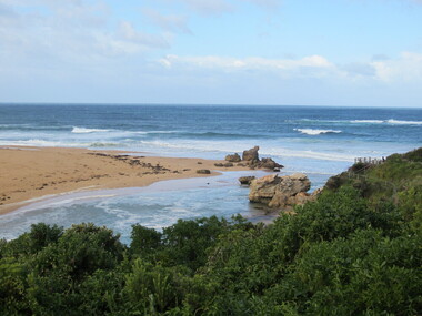
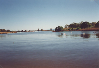
Photograph - Colour, Mouth of the Hopkins River, Warrnambool, 2012, 18/08/2012
Colour photographs of the mouth of the Hopkins River at Warrnambool.warrnambool, hopkins river, mouth, sea -
 Ballarat Heritage Services
Photograph, Lisa Gervasoni, Bridge over the Avoca River, Victoria, 2011, 06/08/2011
Colour photographs of a bridge over the Avoca Riveravoca, avoca river, pre olympic swimming pool -
 Ballarat Heritage Services
Photograph, River Boats Below Murray Bridge, South Australia
River Boats on Murray Bridge, South Australia.river boats, murray bridge, south australia -
 Ballarat Heritage Services
Photograph - Colour, L.J. Gervasoni, River at Avoca, 2011, 06/08/2011
Colour photograph of the swimming hole in the River at Avoca. avoca, pre-olympic swimming pool, avoca river -
 Ballarat Heritage Services
Photograph - Colour, L.J. Gervasoni, Bridge Over the River, Avoca, 2011, 06/08/2011
Colour photograph of the Bridge Over the River at Avoca.avoca, bridge, avoca river -
 Ballarat Heritage Services
Photograph - Colour, L.J. Gervasoni, Bridge Over the River, Avoca, 2011, 06/08/2011
Colour photograph of a bridge over the Avoca River.avoca, bridge, avoca river -
 City of Greater Geelong
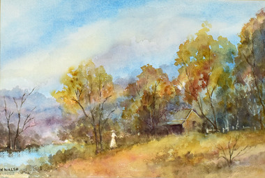
Work on paper - Watercolour, N Walsh, By the River
Rural scene with cottage and river and lots of vegetation -
 Greensborough Historical Society
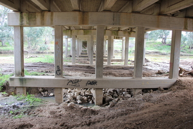
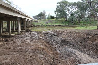
Photograph - Digital image, Marilyn Smith, Plenty River bank stabilisation 2015; path along the river, 16/08/2015
River bank stabilisation project along the Plenty River at Greensborough 2015, conducted by Melbourne Water. This photo shows the path beside the Plenty River in Greensborough.Digital copy of colour photographplenty river, melbourne water -
 Orbost & District Historical Society
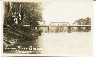
black and white photograph, first half 20th century
This is a photograph of the second Snowy River Bridge at Orbost. The section in the central span could have been built after flood damage. This bridge over the Snowy River was opened on July 4 1922. It was constructed in 1922 alongside the previous suspension bridge. Its building was a combined effort of the Victorian Railways and the Country Roads Board at a cost of 35,000 pounds. It was replaced in 1976 by the present bridge after several major floods.This bridge was replaced in 1976 after several major floods.A black / white photograph / postcard of a bridge over a river. It has what looks like a bo girder in the central section. On the left is the river bank.on front bottom left - "SNOWY RIVER BRIDGE"orbost snowy-river-bridge transport-bridge -
 Port of Echuca
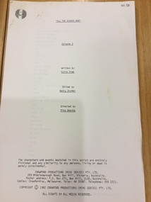
Document - Television script, Crawford Productions, All the Rivers Run Episode 3, 1982
This original script was from a television mini series titled 'All The Rivers Run' that was filmed in Echuca in 1982. The production took over the township for many months and was often filmed on board the Port of Echuca's paddle steamers.This original script from the mini series 'All the Rivers Run' is of social significance as it was filmed on location at the Port of Echuca and surrounding Echuca township. There are very few remaining scripts in existence. 70 page printed script of Episode 3 All the Rivers Run mini series 'All the Rivers Run' Episode 3 Written by Colin Free, Edited by Betty Archer, Directed by Pino Amenta. Copyright 1982 Crawford Productions Pty Ltd script, paper, miniseries, echuca, river, crawford productions, port of echuca -
 Heidelberg Golf Club
Book, Melbourne Parks and Waterways, Lower Plenty River concept plan: Maroondah Pipe Track to Yarra River, 1994
Lower Plenty River concept plan: Maroondah Pipe Track to Yarra River. Includes suggestion of Plenty River Trail along the west boundary of the Heidelberg Golf Club.66 p., illus., colour map. Also, Draft copy of document.plenty river trail, lower plenty river, heidelberg golf club, mmbw, melbourne parks and waterways -
 Federation University Historical Collection
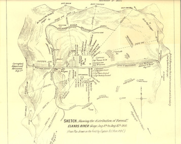
Plan, Sketch of Elands River Siege, 1900
Plan based on the field notes of Captain David John Ham, V.B.C. For article written by Ham on the event, see http://trove.nla.gov.au/ndp/del/article/9542500 For obituary of Ham, see http://trove.nla.gov.au/ndp/del/article/11023251Sketched paper map of forces' distribution at the Elands River siege. Map details surrounding hills, roads, rivers, and names all soldiers involved in siege. boer war, map, sketch, victorian's bushmen contingent, hocking, fowles, methuens, david john ham -
 Lakes Entrance Historical Society
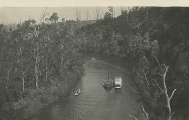
Postcard, Tambo River Cliffs/Lady Harriet Barge, 1914 c
Note on back written by A Gall who was head teacher at Tambo Upper school 1887 -1920Black and white postcard showing views of Tambo River cliffs and Lady Harriett barge on the river plus two smaller boats Tambo Upper Victoriawaterways, boats and boating -
 Lakes Entrance Historical Society
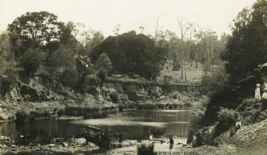
Photograph - Mitchell River, Eagle Point Victoria
Colour photograph of Mitchell River at entrance to silt jetties near Eagle Point Victoria. Plus two other photos of Mitchell River at Eagle Point waterways, topography -
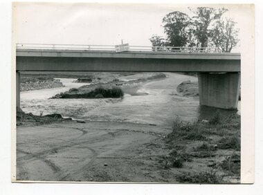 Orbost & District Historical Society
black and white photographs, October 22 1976
The road to Marlo was cut by flood waters from the Snowy River in two places. The road was closed when water flowed over Gilbert's Gulch (3243.1) The Snowy River broke its banks and flooded surrounding Orbost, Marlo, Lochend and Jarrahmond were isolated. The river bank at the bridge site was broken and filled with earth and rock fill. (3243.2) The new Snowy River Bridge was nearing completion when the river rose 7.2 metres causing erosion on the eastern bank. (3243.7) Contractors involved in the construction of the Princes Freeway and bridge were delayed by the flood waters. (3243.8) The 1976 flood at Orbost was a significant event which delayed the construction of the current Snowy River Road Bridge.These photographs record that event.Nine black / white photographs of flood waters across roads. orbost-flood-1976 snowy-river-bridge marlo-road-flood-1976 gilbert;s-gulch-flood -
 Ballarat Heritage Services
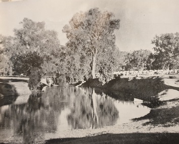
Photograph, River
river -
Glenelg Shire Council Cultural Collection
Booklet - Booklet - Nelson and Glenelg River, Victoria, Compiled by N.F. Learmonth, Three Ways to Cross a River, Mar-63
Booklet - 'Three Ways to Cross a River', a short history of Nelson, focussing on the crossings of the Glenelg River - ford, punt and bridge. Blue card, cover, black print. Complied to mark the occasion of the opening of the new Glenelg River bridge at Nelson, 14 Mar 1963 -
 Lakes Entrance Historical Society
Postcard - Nicholson River, Bulmer and Segenberg Bairnsdale, 1910
Also a second black and white postcard showing two rowboats on river at wide bend 05350.1 8.5 x 13.5 cmBlack and white postcard showing view of Upper Nicholson River with three women shown, water level low Nicholson VictoriaNicholson River waterways, boats and boating -
 Melbourne Legacy
Slide, Operation Firewood - Red Gum Forest, Murray River, 1960s
Colour slide of red gum trees in a forest near the Murray River. It was during Operation Firewood. Legatees would organise collection of wood from the country and distribute it to widows in metropolitan Melbourne. More photos show the cutting and loading of wood and delivery to widows in metropolitan Melbourne. Was with many other slides taken in the 1950s and 1960s. The slides have been photographed to make digital images and moved to archive quality sleeves. In many cases the original images were not well focussed and the digital image the best available.A record of Legacy helping widows by sourcing, supplying and delivering firewood. When open fires were the main source of heating, a load of firewood and help moving it, would have been very important to the widows.Colour slide of trees in a Red Gum forest during Operation Firewood in brown Anscochrome cardboard mount. Printed on reverse in red ink 'Processed by Verycolor photo labs. Melbourne, Victoria'.Printed on front in red ink 'Anscochrome / View from this side / Made in Australia'. Hand written on front 'Red gum trees / River Murry' in blue pen.operation firewood, trees, forest -
 Lakes Entrance Historical Society
Photograph, Tambo River looking upstream from McMeekins Killarney Tambo Upper Victoria, 1/02/2024 12:00:00 AM
Black and white photograph of view of Tambo River looking upstream from McMeekins Killarney Tambo Upper Victoria. Also two similar photographs of Tambo River boats and boating, waterways -
 Kew Historical Society Inc
Photograph, Floods in North Kew, 1971
Living with natural processes was frequently a challenge to early European settlers and later residents of what was in the 1850s administered by the Borondara Road Board. This was compounded by the area being bounded on three sides by rivers (Yarra River, Koonung Creek and Gardiner's Creek). In 1849, the historian James Bonwick recorded that "our district [Kew] suffered considerably. Mr Wade speaks of 80 acres, out of 100 acres of his cultivated paddock, covered by water." Newspapers continued to describe major flooding in Kew in 1863, 1869, 1878, 1880, 1889, 1891, 1916 and 1934. While the construction of the Upper Yarra dam in 1957 reduced the levels of flowing downstream, local and riverine floods continue.The Kew Historical Society's pictures and map collections testify to the impact of flooding in the district. They have historical importance in documenting the extent of flooding in the district and its affects on homes, services and recreation. Numerous photographs record flooding throughout the Twentieth Century.Floods in North Kew, 1971. Looking northeast towards Kilby Road from River Avenue. Annotation on reverse: map and date "8 Nov. 71 10.30am".floods (kew), yarra river, kew flood, kilby road flood -
 Orbost & District Historical Society
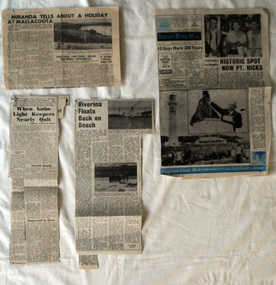
newspaper clippings, mid 20th century?
This folder of newspaper articles was compiled by Mary Gilbert. Mary Isabelle Gilbert was born in 1905 in Orbost, Australia. She was born to John Gilbert and Annie Cameron Gilbert, and had seven sisters and one brother. Four siblings died at a young age. .She was a teacher historian loved and respected by her family and the wider community. The articles are generally pertaining to Gabo and Point Hicks.These articles are contemporary records of interest in places close to Orbost and are a useful reference tool.A manila folder of black / white newspaper articles relating to Orbost and the surrounding district. 744.2 is titled, " Miranda Tells About a Holiday at Mallacoota". 744.3 is from the Snowy River Mail and is titled, " Historic Spot Now Pt Hicks". 744.4 is from the Snowy Mail and is titled, "Riverina Floats Back on Beach". 744.5 is from the Snowy River Mail and has three articles: "When Gabo Light Keepers Nearly Quit"; "Sydney Convicts For Gabo?'; "Nothing to Eat But Shark".newspaper-articles-gabo- point hicks riverina -
University of Melbourne, Burnley Campus Archives
Photograph - Black and white print, 30c Rose Bed & View of Trees Near River
Labelled,"Rose Bed & View of Trees Near River."rose bed, trees, mrs. jessep, alexander william jessep, principal, a.w. jessep -
 Lorne Historical Society
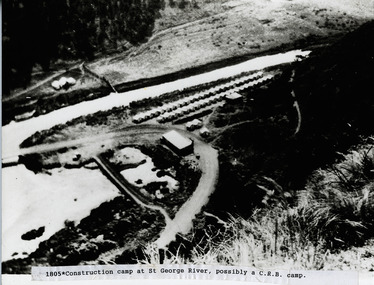
Photograph, St. George River C.R.B. Camp
Photo of the C.R.B. Construction Camp at St George Riverg.o.r.: c.r.b. camp site: st george river. -
 Lorne Historical Society
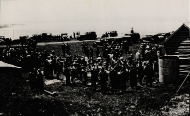
Photograph, Opening Ceremony G.O.R. at Wye River 1932
Photograph of G.O.R. Opening Ceremony at Wye River, 1932opening-ceremony-wye-river-1932; g.o.r -
 Lorne Historical Society
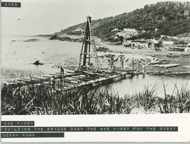
Photograph, Building of the bridge at Wye River, on G.O.R
Photograph showing construction of the bridge at Wye River on the G.O.R.g.o.r; wye-river; g.o.r; bridge-construction; -
 Brimbank City Council Art Collection
Photograph, Robert Pointon, West Bank of Maribyrnong River, North Sunshine, 1987
Local SceneWest Bank of Maribyrnong River, North Sunshine - AR0034 -
 Wodonga & District Historical Society Inc
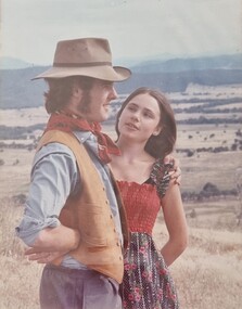
Album - Ringer's River by Des Martin - Finis
Time heals all wounds. Federation is now a fact, and Sean O'Day, managing partner in Gooloora Station can look far across the rolling country in which his children will grow up as individual members of a single nation. There is still much to be done, and the miles, and the years, and the future are calling him to the task, while the Mona Lisa-like expression of his young bride seems to say, "Yes, you have your dreams of a world to run, but I can find all my happiness in running a home for you!" FINIS.The album and images are significant because they document literature written by a prominent member of the Wodonga community. The presentation of this precis was supported by several significant district families and individuals.Ringer's River Album Coloured photo - Final Scene.des martin, many a mile, ringer's river, northeast victoria stories -
 Wodonga & District Historical Society Inc
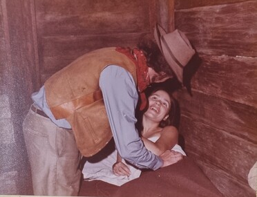
Album - Ringer's River by Des Martin - Plate 37 - Reunion
Convalescent but weak, Erin is asleep in the sapling and bag bed in the corner of Pulcherry's slab hut when O'Day finds her. Wakened by his voice she momentarily thinks he is a hallucination, but the touch of his hands sends her own arms reaching up to claim him as her own.The album and images are significant because they document literature written by a prominent member of the Wodonga community. The presentation of this precis was supported by several significant district families and individuals.Ringer's River Album Coloured photo Plate 37des martin, many a mile, ringer's river, northeast victoria stories