Showing 296 items matching "river crossing"
-
 Melbourne Tram Museum
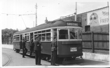
Photograph - Set of 5 Black & White - First AETA tour, 15-2-1947
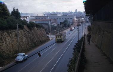
Set of five photographs of the first Australian Electric Traction Association (AETA) tram tour of Melbourne on 15/2/1947. See page 8 of the March 1947 issue of "Tram Tracks" for details of the tour and the MMTB Crew. 1 - SW6 881 about to leave Glen Huntly Depot 2 - Crossing Balaclava Junction 3 - Crossing the Kooyong railway level crossing in Glenferrie Road - has the railway signal box and gates in view. 4 - Turning into Riversdale Road from Glenferrie Road with the Stotts Business College building in the background. 5 - Just to the east of Yarra River Bridge in Swan Street with the Burnley Gardens on the right.Yields information about the first AETA tram tour in 1947Set of 5 Black and white photograph on paper. Two copies of each held.Each one of the set has a photographers file stamp on the rear, but no details filled in.trams, tramways, aeta, tram tours, tram 881, sw6 class, glen huntly, kooyong level crossing, glenferrie road, riversdale road, burnley, hawthorn, balaclava junction, glen huntly depot, hawthorn road, swan st -
 Melbourne Tram Museum
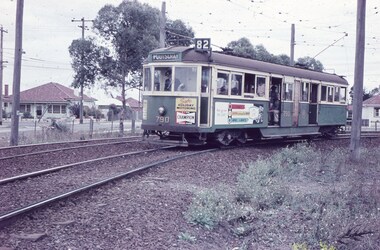
Slide - Set of 2, Keith Caldwell, 10/03/1960 12:00:00 AM
... Trams tramways Maribyrnong Footscray Rosamond Rd River St Level ...Set of 2 Agfa Colour slide, cardboard mount, by Keith Caldwell of 10 March 1960 - .1 - W5 790, turning on Rosamond Road Maribyrnong into River St, destination of Footscray, Route 82. Tram has the adverts for Champion spark plugs and a recruiting advert for MMTB Conductors. .2 - W5 790 returning, photographed in Rosamond Road, destination Moonee Ponds, Route 82. Has an adverts for Knight? and Tulip? Note the cattle guard on the level crossing and the "Trams No Road Only" and "No Road" signs.All hand stamped "10 Mar '60". .1 - marked "Footscray Connection"trams, tramways, maribyrnong, footscray, rosamond rd, river st, level crossings, w5 class, route 82, moonee ponds, tram 790 -
 Melbourne Tram Museum
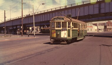
Photograph - Set of 3 Colour Negatives, Phil A'Vard, 10/02/1962 12:00:00 AM
Set of 3 photographs taken on the AETA tour Sat. 10/2/1962 - Closure of the Local Tram Routes at Footscray. .1 - W4 670 passing under the King St bridge in Queensbridge St, South Melbourne. Has an AETA tour Auxiliary board is showing Special. .2 - ditto, followed by W3 655 crossing the Maribyrnong Road Bridge. .3 - ditto - turning on the reserved track alongside Wests Road. Taken on Perutz film - see 3997 for the AETA Tour circular. and see 5998 for other photographs.trams, tramways, footscray, aeta, maribyrnong river bridge, maribyrnong rd, wests rd, queensbridge st, w4 class, w3 class, tram 670 -
 Melbourne Tram Museum
Negative - Set of 2, Ellis Collection, c1940?
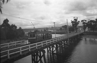
Set of two Negatives (120) of a wide body car crossing the Wallen St Road Bridge Hawthorn possibly after the construction of The Boulevard. Taken from either side of the river. Hi Res image filed in the dbtext/hawthtramcoll/Large Images/htd3595aLarge.jpg and htd3595bLarge A low resolution A4 laminated was received with the negatives. Image i2 - taken from Glan Avon Rd in Hawthorn of Wallen Rd bridge – the tram is one of three SW2 class trams (not the first one due to the door sizes, but one of 426, 432 or 478, most probably 478 as that was a Camberwell car)trams, tramways, wallen rd, bridges, sw2 class -
 Melbourne Tram Museum
Slide - Set of 2, John Webster, 14/06/1960 12:00:00 AM
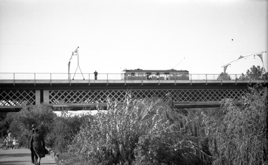
Set of two Colour slides Kodak, white cardboard of trams: .1 - an SW6 (route 42) car descending the Barkers Road hill through the cutting towards Victoria Bridge over the Yarra river, Has the Vickers Ruwolt factor in the background and the city skyline. .2 - SW6 893 (City Route 42), crossing the Victoria Bridge after leaving the Barkers Road cutting. Shows the overhead support structure on the bridge. Slide datedHand writing on rear in ink "14-6-60 - Retrieving a trolley pole Church St Hawthorn."trams, tramways, route 42, barkers road, sw6 class, bridges, victoria bridge, tram 893 -
 Melbourne Tram Museum
Negative, Wal Jack, c1941
Black and white negative, by Wal Jack, of W2 392 (from information in the Wal Jack Album) crossing the Swan St or Wallen St bridge over the Yarra River. Photo not dated, in the Wal Jack album.trams, tramways, swan st, wallen road, bridges, w2 class, yarra river, tram 392 -
 Melbourne Tram Museum
Negative, Wal Jack, 10/02/1941 12:00:00 AM
... in Swan St Richmond or Burnley after crossing the Yarra River... or Burnley after crossing the Yarra River bridge. Photo dated 10-2 ...Black and white negative, by Wal Jack, of No.Y1 611 inbound in Swan St Richmond or Burnley after crossing the Yarra River bridge. Photo dated 10-2-1941 in the Wal Jack album along with details of the location.trams, tramways, swan st, y1 class, burnley, tram 611 -
 Melbourne Tram Museum
Negative, Wal Jack, 1/09/1941 12:00:00 AM
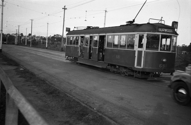
... , Route 74) in Swan St Burnley, prior to crossing the Yarra River...) in Swan St Burnley, prior to crossing the Yarra River. Photo ...Black and white negative, by Wal Jack, of CW5 681, (Burwood, Route 74) in Swan St Burnley, prior to crossing the Yarra River. Photo dated 1-9-1941 in the Wal Jack album along with details of the location.trams, tramways, burnley, cw5 class, swan st, route 74, tram 681 -
 Melbourne Tram Museum
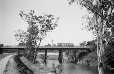
Negative, Wal Jack, 1943-44
... Special B, crossing the Maribyrnong River Bridge westbound... Trams tramways W5 class Special B Maribyrnong River Bridge ...Black and white negative, by Wal Jack, of W5 832, showing Special B, crossing the Maribyrnong River Bridge westbound with a number of passengers. The tram only bridge has been duplicated during September 1943. Photo not dated in the Wal Jack album, c1943 - 44trams, tramways, w5 class, special b, maribyrnong river bridge, maribyrnong rd, world war 2, tram 832 -
 Melbourne Tram Museum
Photograph - Digital Image, Kevin O'Reilly, series of three images of the Hawthorn Bridge over the Yarra, c1930, c1930's
Image from CD (Compact Diskette for use in computers) - see Reg Item 135. A series of three images of the Hawthorn Bridge over the Yarra, c1930, during the era with problems with the bridge. See separate article for more details. Richmond 6, Richmond, Richmond 3 on the CD as original files. .1 - Looking from the south west, at the Hawthorn bridge with the temporary wooden bridge being constructed on the south side. Has the cable tram depot in the photo and part of the Burnley racing course. Temporary track on the north side of the steel bridge and crossings can be seen. .2 - Looking along Bridge Road to the east with Hawthorn Bridge in the middle of the photograph. Shows the industrial and residential areas, Hawthorn Railway Station and part of the Burnley Race course, the cable tram depot building. W class tram in Church St Hawthorn and W class tram crossing the bridge on the north side temporary track. Note the cable tram used as a shelter on the north east corner of the bridge. .3 - Looking south along River St towards Bridge Road, with the Yarra River and Hawthorn Bridge on the left side of the photograph. Shows the industry in the area at the time, wool and skin Merchants, north side of the cable depot, housing and the outlook to the river!trams, tramways, hawthorn, yarra river, burnley, richmond, hawthorn bridge -
 Melbourne Tram Museum
Photograph - Digital Image, Kevin O'Reilly, Richmond looking east along the Yarra River, c1930's
Image from CD (Compact Diskette for use in computers) - see Reg Item 135. Image titled "Richmond 7" on CD, of looking east along the Yarra River where the Church St Bridge Richmond crosses the River, Alexandra Ave. Has an ex HTT Maximum Traction tram crossing the bridge. Shows now Herring Island after the Yarra River was cut through to form the island.trams, tramways, richmond, chapel st, church st, yarra river -
 Melbourne Tram Museum
Ephemera - Calendar, Topmill Pty Ltd, "Australian Trams - 1996 Calendar", 1995
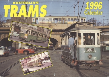
... large format photos of 672 crossing the wooden Maribyrnong River... crossing the wooden Maribyrnong River Bridge, 672, 671, 980, X2 676 ...Wall Calendar - heavy card covers, 12 gloss art pages inside, titled "Australian Trams - 1996 Calendar" containing cull colour photographs of Sydney, Adelaide, Bendigo, Ballarat, Melbourne, Fremantle 29 and Victor Harbor. Has a punched hole along the top edge to enable wall use. Provides dates for holidays, school holidays and Pension payment days and phases of the moon. Produced by Topmill Pty Ltd and distributed by Gordon & Gotch Pty Ltd. All Photos by Dr D. Ellerton. Features large format photos of 672 crossing the wooden Maribyrnong River Bridge, 672, 671, 980, X2 676, X 217, VR 52, S164 Second copy from AETA collection added 17/1/1014.trams, tramways, ballarat, bendigo, melbourne, adelaide, sydney, tram 672, tram 671, tram 980, tram 217, tram 52, tram 164 -
 Stawell Historical Society Inc
Photograph, Roadway and crossing which was the site of the Glenorchy Weir
Roadway and crossing which was the site of the Glenorchy Weir. Part of water supply scheme which was completed in 1882 and used until approximately 1900.Black & white photograph showing a steep dirt roadway and crossing over a water body. Trees surrounding the roadway.water river -
 Greensborough Historical Society
Photograph - Photograph - Digital Image, Marilyn Smith, Aqueduct crossing the Plenty River, Greensborough 2019, 02/07/2019
... Aqueduct crossing the Plenty River, Greensborough 2019...The aqueduct crossing the Plenty River, 2019, overgrown...The aqueduct crossing the Plenty River, 2019, overgrown ...The aqueduct crossing the Plenty River, 2019, overgrown with vegetation. Originally part of the Maroondah Aqueduct pipeline, all that remains is the bridge that once carried the pipe over the Plenty River. This photograph was taken from the Plenty River Trail in Greensborough. 3 colour digital photographsplenty river trail, maroondah pipetrack, maroondah aqueduct, plenty river, graffiti -
 Stawell Historical Society Inc
Photograph, Glenorchy Bridge on the Wimmera River 1866
Glenorchy Bridge Wimmera River. Part of a collection of Photographs by Mr. O.G. Armstrong as commissioned by the Shire of Stawell for the Inter-colonial and Paris Exhibition in Melbourne in 1866. Prior to the construction of this bridge in 1860, there existed two forwards across the Wimmer River at Glenorchy. One was 2 miles on the Stawell side of Glenorchy and 500 metres from the present railway bridge. It was well made, stone floor and can be seen today. The second was located 800 metres downstream of the town and was known as Stuart’s Crossing. These Fords were popular crossing spots for Bullock Drays which were delayed for days during floods before the bridge was built. The original Bridge was built near the site of the present ‘old’ bridge. stawell -
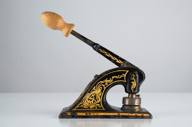 City of Greater Bendigo - Civic Collection
Ceremonial object - Common Seal
Bridgewater is a situated 39km northwest of Bendigo and 170 km from Melbourne. It was established as a crossing point over the Loddon River for gold diggers en route to the Inglewood gold diggings. As gold began to dry up in the district the town of Bridgewater developed due to its proximity to the river which it relied on for industries such as brewing, farming and market gardens. As demand on the water supply grew, the Water Works were established to ensure supply and manage the quality of the water for drinking. Decorated hand operated cast iron embosser with 40mm seal head attached. Gold and orange painted decorations extend from top edge of handle to sides of base. Original knob has been replace with a newer wooden knob. Well used showing all over signs of wear. Seal is for the Bridgewater Waterworks Trust 1927.Bridgewater Waterworks Trust 1927.loddon shire -
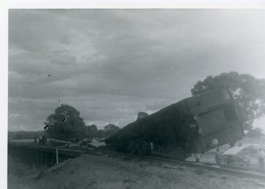 Stawell Historical Society Inc
Photograph, Train Derailment near Glenorchy February 1971-- 6 Photos, 1971
Series of six photographs of Train derailment near Glenorchy February 1971. These Photographs are copies o=from negatives held by the society - Made possible by grant 1991. These photographs taken of a train accident. The Afternoon Passenger Train - at the level crossing on the Warracknabeal - Stawell Road. There are 2 crossings on the road - This crossing is near the Wimmera River Rail Bridge. The cause of the accident - was a collision between a loaded Gravel truck and the passenger train. The Driver of the Truck was killed. 1231-2 B/w Photo of Train Smash near Glenorchy. This photo was donated from the estate of Mr Boothey in 2010, and is almost identical to one in 1231. This Photo is in album 4. B/W Photos of a Train Smash - 1231 The deisel Engine completely derailed off the rail line. 1231-1 showing the derailed rolling stock from another angle. Many onlookers. 1231-2 The Boogie is completely off the carriage 3 Photogrpahsstawell railways transport, glenochy -
 Lakes Entrance Historical Society
Photograph - Swan Reach Bridge, 1/12/2027 12:00:00 AM
The temporary bridge was in use until for four years, following the collapse of the permanent bascule bridge on 17 November 1925 due to attack by teredo worm. The temporary bridge was swept away during a flood in June 1930.Sepia toned photograph of a pontoon bridge over the Tambo River at Swan Reach Victoria, built as a temporary crossing after the collapse of the bascule bridge on 17 November 1925. Tambo River Christmas 1927 on reversereligion, buildings -
 Greensborough Historical Society
Article, R. A. Marsh, Church Street Greensborough, 1907_
... and Partington families. In particular a dispute about a log crossing... and Partington families. In particular a dispute about a log crossing ...Deals with a tenancy agreement between the Marsh and Partington families. In particular a dispute about a log crossing on the Plenty River, the access to which was across Marsh's land. There is also a brief family history of the Marsh family in Greensborough.Marsh and Partington families are Greensborough pioneer families.Collection of documents relating to the Marsh family. Some handwritten documents.marsh family, partington, greensborough, plenty river, church street greensborough, hailes street greensborough -
 Lakes Entrance Historical Society
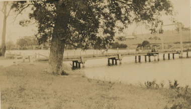
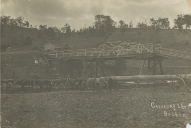
Photograph, John Flynn, Crossing the Buchan, 1906
Bridge was built in 1896 and never finishedBlack and white photograph of bullock team pulling timber jinker with very long logs across the Buchan River beside the footbridge. Several men in charge of team and four girls on the hill, cottage and barn seen, bridge not finished Buchan VictoriaCrossing the Buchantransport, waterways, bridges, people -
 Chelsea & District Historical Society Inc
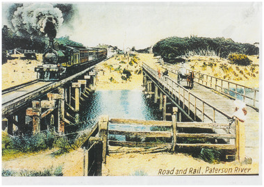
Photograph - Patterson River Postcards, Rail and Road Bridge, c 1905
... , with a steam train crossing over Patterson River, near the mouth... , with a steam train crossing over Patterson River, near the mouth ...The first bridge over the river was built in the early 1880's, prior to this it was a pontoon bridge. Dr. Sheldon's Magnetic Liniment was advertised as being able to relieve "at once rheumatism, lumbago, lame back, cuts, bruises or burns, will effect a cure in a remarkably short time. Price 1s 6d and 3s"Two postcards of the road bridge (Nepean Highway) with a horse and cart and people crossing and single line rail bridge , with a steam train crossing over Patterson River, near the mouth of the river. One card has been coloured, the other has been modified to advertise Dr Sheldon's Magnetic Liniment.DR SHELDON'S NEW DISCOVERY 16' & 3' BANISHES ALL PAINS AT CARRUM VICTORIApatterson river, road bridge, rail bridge, dr sheldon's linament, chelsea, steam train, transport, chelsea bridge, patterson bridge -
 Bendigo Historical Society Inc.
Map - Black and white map pertaining to Lake Eppalock
John Perry Collection. Laminated copy of map pertaining to Lake Eppalock. Gives details of dwellings, bridges and ford crossings. The dam was built by the State Rivers and Water Supply Commission of Victoria. The dam wall height is 45 metres (148 ft) and the main embankment is 1,041 metres (3,415 ft) long. At 100% capacity the dam wall was designed to hold back 304,651 megalitres (6.7014×10¹⁰ imp gal; 8.0480×10¹⁰ US gal) of water. The surface area of Lake Eppalock is 3,011 hectares (7,440 acres) and the catchment area is 2,124 square kilometres (820 sq mi). The controlled spillway is capable of discharging 8,040 cubic metres per second (284,000 cu ft/s). Lake Eppalock supplies both stock and domestic water to the Campaspe irrigation district. It also serves as a water supply to Bendigo and Heathcote and, in more recent times, Ballarat. The lake is a major attraction for those engaging in watersports, with a number of tourist parks and accommodation facilities available. Permissible activities on the lake include high-speed boating, water skiing, sailing, canoeing, fishing and swimming. The lake's water levels were low for approximately eight years between 2002 and 2010 during a prolonged drought, which restricted the amount of recreational activity until rainfall in the latter half of 2010 returned the lake to 100 percent capacity. Built between 1961 and 1964, Lake Eppalock remains the only water storage on the Campaspe River system.eppalock, map, water, dam, reservoir -
 Bendigo Historical Society Inc.
Document - Directions to Lake Eppalock with road descriptions and map
John Perry Collection. Laminated copy of 'Directions to Lake Eppalock'. Gives directions in relationship of Lake Eppalock to Bendigo, Kyneton and Heathcote. Undated. Gives basic descriptions of bridges on lakebed, ford crossings on lakebed and inundated dwellings on lakebed. The dam was built by the State Rivers and Water Supply Commission of Victoria. The dam wall height is 45 metres (148 ft) and the main embankment is 1,041 metres (3,415 ft) long. At 100% capacity the dam wall was designed to hold back 304,651 megalitres (6.7014×10¹⁰ imp gal; 8.0480×10¹⁰ US gal) of water. The surface area of Lake Eppalock is 3,011 hectares (7,440 acres) and the catchment area is 2,124 square kilometres (820 sq mi). The controlled spillway is capable of discharging 8,040 cubic metres per second (284,000 cu ft/s). Lake Eppalock supplies both stock and domestic water to the Campaspe irrigation district. It also serves as a water supply to Bendigo and Heathcote and, in more recent times, Ballarat. The lake is a major attraction for those engaging in watersports, with a number of tourist parks and accommodation facilities available. Permissible activities on the lake include high-speed boating, water skiing, sailing, canoeing, fishing and swimming. The lake's water levels were low for approximately eight years between 2002 and 2010 during a prolonged drought, which restricted the amount of recreational activity until rainfall in the latter half of 2010 returned the lake to 100 percent capacity. Built between 1961 and 1964, Lake Eppalock remains the only water storage on the Campaspe River system.water, dam, directions, eppalock -
 Bendigo Historical Society Inc.
Map - Black and white map pertaining to Lake Eppalock
John Perry Collection. Laminated copy of map relating to Lake Eppalock. Lists dwellings, ford crossings and bridges. The dam was built by the State Rivers and Water Supply Commission of Victoria. The dam wall height is 45 metres (148 ft) and the main embankment is 1,041 metres (3,415 ft) long. At 100% capacity the dam wall was designed to hold back 304,651 megalitres (6.7014×10¹⁰ imp gal; 8.0480×10¹⁰ US gal) of water. The surface area of Lake Eppalock is 3,011 hectares (7,440 acres) and the catchment area is 2,124 square kilometres (820 sq mi). The controlled spillway is capable of discharging 8,040 cubic metres per second (284,000 cu ft/s). Lake Eppalock supplies both stock and domestic water to the Campaspe irrigation district. It also serves as a water supply to Bendigo and Heathcote and, in more recent times, Ballarat. The lake is a major attraction for those engaging in watersports, with a number of tourist parks and accommodation facilities available. Permissible activities on the lake include high-speed boating, water skiing, sailing, canoeing, fishing and swimming. The lake's water levels were low for approximately eight years between 2002 and 2010 during a prolonged drought, which restricted the amount of recreational activity until rainfall in the latter half of 2010 returned the lake to 100 percent capacity. Built between 1961 and 1964, Lake Eppalock remains the only water storage on the Campaspe River system.map, water, dam, reservoir, eppalock -
 Federation University Historical Collection
Postcards - black and white, Butt Bourton, Burford
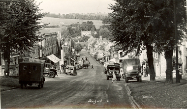
... town or hilltown and ford, the crossing of a river. (Wikipedia)... town or hilltown and ford, the crossing of a river. (Wikipedia ...Burford is a small town on the River Windrush in the Cotswold hills in west Oxfordshire, England, about 18 miles (29 km) west of Oxford, 22 miles (35 km) southeast of Cheltenham and only about 2 miles (3 km) from the Gloucestershire boundary. The toponym derives from the Old English words burh meaning fortified town or hilltown and ford, the crossing of a river. (Wikipedia)A streetscape photographic view of Burford, England showing buildings, cars and people. chatham family archive, burford -
 Emerald Museum & Nobelius Heritage Park
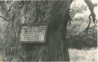
Photograph - Photograph of plaque commemorating Major Mitchell
... crossing of the Ovens River (1836) in the footsteps of Hume... commemorating Major Mitchell's crossing of the Ovens River (1836 ...This plaque was unveiled on 23 April 1915 to commemorate early colonial explorers, Major Mitchell and before him, Hume and Hovell. These explorers crossed the Ovens River in 1824 and 1836. The plaque has now been replaced by a tablet. This photograph and other postcards and photographs came from the estate of David Moyle (1938-2015) who was a police officer in Emerald during late 1960s-early 1970s, and subsequently at Belgrave in the early 1980s. David Moyle was closely associated with the now defunct Sherbrooke Historical Association. This photograph is significant because it recalls the early history of Victorian colonial exploration and settlement and is emblematic of the importance placed by the local community on Major Mitchell's and Hume and Hovell's explorations. Also, this photograph is part of a collection belonging to a community member who had a close association with a local historical society.Photograph of plaque on tree commemorating Major Mitchell's crossing of the Ovens River (1836) in the footsteps of Hume and Hovell (1824). david moyle, police, emerald, belgrave, major mitchell, hume and hovell, ovens river, plaque