Showing 634 items matching "river view"
-
 Marysville & District Historical Society
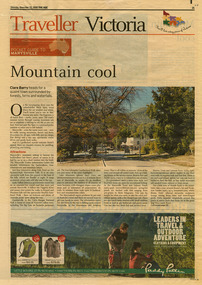
Newspaper (Item) - Newspaper article, The Age, POCKET GUIDE TO MARYSVILLE, 22-11-2008
A newspaper article on Marysville, its local attractions, places to shop and dine, where to stay and ways of traveling to Marysville. This article was published in The Age on Saturday, November 22, 2008.A newspaper article on Marysville, its local attractions, places to shop and dine, where to stay and ways of traveling to Marysville.marysville, victoria, australia, the age, black spur, marysville visitor information centre, steavenson falls, lady talbot drive, taggerty river, keppel falls, phantom falls, beeches rainforest walk, cambarville, yarra ranges national park, the big tree, cumberland walk, lake mountain, steavenson river, acheron river, buxton bait and tackle, marysville trout and salmon ponds, buxton trout and salmon farm, bruno's art and sculpture garden, villa day spa, cathedral view natural therapies, marysville massage, murchison street, village walk, uncle fred & aunty val's old style lolly shop, country touch gallery, manical mechanicals, hidden talent craft gallery, carmyle farm boutique, marysville community market, marysville patisserie, marysville country bakery, fraga's cafe restaurant, terracotta room, marylands country house, the cumberland, mantirri blueberry farm, narbethong, marysville farmers market, the black spur inn, allawah country cottages, barree mud brick cottages -
 Marysville & District Historical Society
Map (Item) - Tourist map, Mystic Mountains Tourism, OFFICIAL VISITORS' MAP MARYSVILLE LAKE MOUNTAIN, Unknown
A visitors' map of Marysville and Lake Mountain produced by Mystic Mountains Tourism for Visit Victoria.A visitors' map of Marysville and Lake Mountain produced by Mystic Mountains Tourism for Visit Victoria.The Marysville and Lake Mountain Visitor Map and Touring Guide has been compiled and/ published by Mystic Mountains Tourism Inc. Copyright./ Production and artwork Graph Attack P/Lmarysville, lake mountain, victoria, australia, visitor's map, official visitors' map marysville lake mountain, buxton, narbethong, taggerty, visit victoria, mystic mountains tourism inc, graph attack p/l, mystic mountains, marysville triangle, marysville visitor information centre, marylands country house, black spur, steavenson falls, lady talbot drive, cambarville, cathedral ranges, wirreanda festival, lake mountain summit walk, summit walk loop, leadbeaters loop, day loop walk, buxton hotel, igloo roadhouse, karmann waters, silverstream b&b cottages, buxton trout and salmon farm, the niche wine bar, buxton post office & general store, choppers buxton roadhouse, woodlands rainforest bungalows, chestnut glade, black spur inn, wombat cottage, abbey lake luxury b&b spa cottages, mystic mountain ski hire & outdoors, pnl 4wdriving, blue views holiday units & ski hire, marapana agistment park & farm stay b&b, danico design, things of sand & stone, mantirri blueberry farm, allawah country cottages, amberview cottages, ashlar cottage b&b, black spur motel & caravan park, blackwood deluxe cottages, blackwood courtyard b&b, dalrymples guest cottages, delderfield, el kanah guest house, fruit salad farm, kerami guest house, keppels hotel, lake mountain-snow gum lodge, lomatia lodge, lyell guest cottages, magnolia house, keppel waters, lyrebird apartments, marysville caravan park, all view spa apartments, riverside cottages, maryton park b&b country cottages, melina cottage, mountain lodge, mystic mountains holiday cottages, nanda binya lodge, rendezvous luxury cottages, scenic b&b motel, the cumberland, south cathedral farm, tower motel, willowbank at taggerty, woodlands rainforest retreat, marysville & district country club inc, mystic mountains ski hire & outdoors, rubicon valley horse riding, marysville trout and salmon ponds, gallipoli park, keppels lookout, cambarville-yarra ranges national park, lake mountain-yarra ranges national park, lady talbot drive-yarra ranges national park, cathedral range state park, steavenson river, taggerty river, acheron river, lake mountain alpine resort, bruno's art and sculpture garden, manical mechanicals, uncle fred & aunty val's old style lolly shop, carmyle farm boutique, crossways historic country inn, fraga's, gilberts restaurant, heights licensed bistro, the old woolshed cafe, cathedral view natural therapies, crystal journey -
 Marysville & District Historical Society
Flyer (item) - Information Flyer, Forests Commission, Victoria, Cumberland Scenic Reserve, 1918-1983
... falls sovereign view armstrong creek yarra river mountain ash ...An information flyer that was produced as a guide to the Cumberland Scenic Reserve by the Forests Commission of Victoria. The Forests Commission Victoria (FCV) was the main government authority responsible for management and protection of State forests in Victoria, Australia between 1918 and 1983. The Commission was responsible for ″forest policy, prevention and suppression of bushfires, issuing leases and licences, planting and thinning of forests, the development of plantations, reforestation, nurseries, forestry education, the development of commercial timber harvesting and marketing of produce, building and maintaining forest roads, provision of recreation facilities, protection of water, soils and wildlife, forest research and making recommendations on the acquisition or alienation of land for forest purposes″. The Cumberland Scenic Reserve is set in the heart of the mountain forests of Victoria and is 16km east of Marysville on the Cumberland Road. This reserve forms part of the catchment of Armstrong Creek, a tributary of the Yarra River which provides water for the Melbourne area. The reserve is a prime mountain ash area in which is set the old Cambarville sawmill and village site.An information flyer that was produced as a guide to the Cumberland Scenic Reserve by the Forests Commission of Victoria. 423Aforests commission victoria, cumberland scenic reserve, marysville, victoria, cambarville, the big tree, cora-lyn falls, barton's lookout, cumberland falls, sovereign view, armstrong creek, yarra river, mountain ash -
 Eltham District Historical Society Inc
Photograph, Hume and Hovell Monument, Broadford, Autumn Excursion, Hume and Hovell's 1824 expedition, 26 May 1996, 26/05/1996
[article by Bettina Woodburn in EDHS Newsletter No. 109, July 1996:] ON THE TRAIL OF HUME AND HOVELL - REPORT ON THE AUTUMN EXCURSION - On a green and fresh morning (Sunday 26th May 1996) the Cobb and Co coach (driven by the most obliging Peter Tampion) set off in a north easterly direction from Eltham to connect with Hume and Hovell's route on their 1824 explorations of central Victoria. The Society would follow a series of monuments erected for the 1924 centenary of the expedition from King Parrot Creek (Tuesday 7th December 1824), through Strath Creek, over Sunday Creek (Sunday 12th December 1824) at Broadford, Tullamarine, St Albans, Deer Park, through Werribee, skirting east of the You Yangs to Lara and Avalon Beach. Because their distance-measuring wheel had broken and a one degree mistake was made in calculations, the two leaders of the original group of six convict-companions arrived at Corio Bay, instead of the expected Western Port, discovered earlier by Flinders. From below Mt. Disappointment (Hume and Hovell's difficulties in "scrambling over brush and rock", "leeches in forest, as well as no water", "cutting grass 4-5 ft. high", dreadful scrub", "devil flies") we took an easier route, saw the Strath Creek memorial in ground fog and a wonderful "field of dreams", the Hume-Hovell privately owned cricket ground with its white picket boundary fence. Now, after a steep climb, in sunshine under gums we stretched and viewed magnificent rolling hills and fog-filled valleys - not "smoke from Aborigines' bush fires". After morning tea at Broadford we followed the Sunday Creek valley beside the Hume Freeway, passed the Wallan Wallan Rest Area (more appropriately Hume and Hovell Rest Area) to tum right at Beveridge. In Gellibrand Hill Park, near the headwaters of the Moonee Ponds Creek, we experienced the landscape the first European settlers saw - huge river red gums and rolling pastures. The gardens and sheltered courtyard of the 1840s, timber, brought from .....[?] prefabricated Woodlands Homestead, provided a pleasant lunch stop. We enjoyed a private tour, panoramic views over Melbourne and surroundings and the excitement of arriving and departing aircraft. Our next river crossing was at Werribee, "in a vast treeless plain", then we drove on by-ways no coach had previously travelled, to find "an immense sheet of water" salty Corio Bay, off-course to the west. In late afternoon of a super, calm, late autumn day we headed homewards. Back at Eltham we were rather surprised to find that we had travelled a total of 347 km. Thanks again to Russell Yeoman for his research and organization. What a wonderful day! Colour photographactivities, broadford, hume and hovell, monument -
 Eltham District Historical Society Inc
Photograph, Strath Creek, Autumn Excursion, Hume and Hovell's 1824 expedition, 26 May 1996, 26/05/1996
[article by Bettina Woodburn in EDHS Newsletter No. 109, July 1996:] ON THE TRAIL OF HUME AND HOVELL - REPORT ON THE AUTUMN EXCURSION - On a green and fresh morning (Sunday 26th May 1996) the Cobb and Co coach (driven by the most obliging Peter Tampion) set off in a north easterly direction from Eltham to connect with Hume and Hovell's route on their 1824 explorations of central Victoria. The Society would follow a series of monuments erected for the 1924 centenary of the expedition from King Parrot Creek (Tuesday 7th December 1824), through Strath Creek, over Sunday Creek (Sunday 12th December 1824) at Broadford, Tullamarine, St Albans, Deer Park, through Werribee, skirting east of the You Yangs to Lara and Avalon Beach. Because their distance-measuring wheel had broken and a one degree mistake was made in calculations, the two leaders of the original group of six convict-companions arrived at Corio Bay, instead of the expected Western Port, discovered earlier by Flinders. From below Mt. Disappointment (Hume and Hovell's difficulties in "scrambling over brush and rock", "leeches in forest, as well as no water", "cutting grass 4-5 ft. high", dreadful scrub", "devil flies") we took an easier route, saw the Strath Creek memorial in ground fog and a wonderful "field of dreams", the Hume-Hovell privately owned cricket ground with its white picket boundary fence. Now, after a steep climb, in sunshine under gums we stretched and viewed magnificent rolling hills and fog-filled valleys - not "smoke from Aborigines' bush fires". After morning tea at Broadford we followed the Sunday Creek valley beside the Hume Freeway, passed the Wallan Wallan Rest Area (more appropriately Hume and Hovell Rest Area) to tum right at Beveridge. In Gellibrand Hill Park, near the headwaters of the Moonee Ponds Creek, we experienced the landscape the first European settlers saw - huge river red gums and rolling pastures. The gardens and sheltered courtyard of the 1840s, timber, brought from .....[?] prefabricated Woodlands Homestead, provided a pleasant lunch stop. We enjoyed a private tour, panoramic views over Melbourne and surroundings and the excitement of arriving and departing aircraft. Our next river crossing was at Werribee, "in a vast treeless plain", then we drove on by-ways no coach had previously travelled, to find "an immense sheet of water" salty Corio Bay, off-course to the west. In late afternoon of a super, calm, late autumn day we headed homewards. Back at Eltham we were rather surprised to find that we had travelled a total of 347 km. Thanks again to Russell Yeoman for his research and organization. What a wonderful day! Colour photographactivities, monument, hume and hovell, murchison valley, strath creek -
 Eltham District Historical Society Inc
Photograph, Murchison Gap viewed from Strath Creek, Autumn Excursion, Hume and Hovell's 1824 expedition, 26 May 1996, 26/05/1996
[article by Bettina Woodburn in EDHS Newsletter No. 109, July 1996:] ON THE TRAIL OF HUME AND HOVELL - REPORT ON THE AUTUMN EXCURSION - On a green and fresh morning (Sunday 26th May 1996) the Cobb and Co coach (driven by the most obliging Peter Tampion) set off in a north easterly direction from Eltham to connect with Hume and Hovell's route on their 1824 explorations of central Victoria. The Society would follow a series of monuments erected for the 1924 centenary of the expedition from King Parrot Creek (Tuesday 7th December 1824), through Strath Creek, over Sunday Creek (Sunday 12th December 1824) at Broadford, Tullamarine, St Albans, Deer Park, through Werribee, skirting east of the You Yangs to Lara and Avalon Beach. Because their distance-measuring wheel had broken and a one degree mistake was made in calculations, the two leaders of the original group of six convict-companions arrived at Corio Bay, instead of the expected Western Port, discovered earlier by Flinders. From below Mt. Disappointment (Hume and Hovell's difficulties in "scrambling over brush and rock", "leeches in forest, as well as no water", "cutting grass 4-5 ft. high", dreadful scrub", "devil flies") we took an easier route, saw the Strath Creek memorial in ground fog and a wonderful "field of dreams", the Hume-Hovell privately owned cricket ground with its white picket boundary fence. Now, after a steep climb, in sunshine under gums we stretched and viewed magnificent rolling hills and fog-filled valleys - not "smoke from Aborigines' bush fires". After morning tea at Broadford we followed the Sunday Creek valley beside the Hume Freeway, passed the Wallan Wallan Rest Area (more appropriately Hume and Hovell Rest Area) to tum right at Beveridge. In Gellibrand Hill Park, near the headwaters of the Moonee Ponds Creek, we experienced the landscape the first European settlers saw - huge river red gums and rolling pastures. The gardens and sheltered courtyard of the 1840s, timber, brought from .....[?] prefabricated Woodlands Homestead, provided a pleasant lunch stop. We enjoyed a private tour, panoramic views over Melbourne and surroundings and the excitement of arriving and departing aircraft. Our next river crossing was at Werribee, "in a vast treeless plain", then we drove on by-ways no coach had previously travelled, to find "an immense sheet of water" salty Corio Bay, off-course to the west. In late afternoon of a super, calm, late autumn day we headed homewards. Back at Eltham we were rather surprised to find that we had travelled a total of 347 km. Thanks again to Russell Yeoman for his research and organization. What a wonderful day! Colour photographactivities, hume and hovell, murchison valley, murchison gap, strath creek -
 Eltham District Historical Society Inc
Photograph, Autumn Excursion, Hume and Hovell's 1824 expedition, 26 May 1996, 26/05/1996
[article by Bettina Woodburn in EDHS Newsletter No. 109, July 1996:] ON THE TRAIL OF HUME AND HOVELL - REPORT ON THE AUTUMN EXCURSION - On a green and fresh morning (Sunday 26th May 1996) the Cobb and Co coach (driven by the most obliging Peter Tampion) set off in a north easterly direction from Eltham to connect with Hume and Hovell's route on their 1824 explorations of central Victoria. The Society would follow a series of monuments erected for the 1924 centenary of the expedition from King Parrot Creek (Tuesday 7th December 1824), through Strath Creek, over Sunday Creek (Sunday 12th December 1824) at Broadford, Tullamarine, St Albans, Deer Park, through Werribee, skirting east of the You Yangs to Lara and Avalon Beach. Because their distance-measuring wheel had broken and a one degree mistake was made in calculations, the two leaders of the original group of six convict-companions arrived at Corio Bay, instead of the expected Western Port, discovered earlier by Flinders. From below Mt. Disappointment (Hume and Hovell's difficulties in "scrambling over brush and rock", "leeches in forest, as well as no water", "cutting grass 4-5 ft. high", dreadful scrub", "devil flies") we took an easier route, saw the Strath Creek memorial in ground fog and a wonderful "field of dreams", the Hume-Hovell privately owned cricket ground with its white picket boundary fence. Now, after a steep climb, in sunshine under gums we stretched and viewed magnificent rolling hills and fog-filled valleys - not "smoke from Aborigines' bush fires". After morning tea at Broadford we followed the Sunday Creek valley beside the Hume Freeway, passed the Wallan Wallan Rest Area (more appropriately Hume and Hovell Rest Area) to tum right at Beveridge. In Gellibrand Hill Park, near the headwaters of the Moonee Ponds Creek, we experienced the landscape the first European settlers saw - huge river red gums and rolling pastures. The gardens and sheltered courtyard of the 1840s, timber, brought from .....[?] prefabricated Woodlands Homestead, provided a pleasant lunch stop. We enjoyed a private tour, panoramic views over Melbourne and surroundings and the excitement of arriving and departing aircraft. Our next river crossing was at Werribee, "in a vast treeless plain", then we drove on by-ways no coach had previously travelled, to find "an immense sheet of water" salty Corio Bay, off-course to the west. In late afternoon of a super, calm, late autumn day we headed homewards. Back at Eltham we were rather surprised to find that we had travelled a total of 347 km. Thanks again to Russell Yeoman for his research and organization. What a wonderful day! Colour photographactivities, hume and hovell -
 Eltham District Historical Society Inc
Photograph, Sign to Hume and Hovell Cricket Ground, at Allandale Road, Strath Creek, Autumn Excursion, Hume and Hovell's 1824 expedition, 26 May 1996, 26/05/1996
[article by Bettina Woodburn in EDHS Newsletter No. 109, July 1996:] ON THE TRAIL OF HUME AND HOVELL - REPORT ON THE AUTUMN EXCURSION - On a green and fresh morning (Sunday 26th May 1996) the Cobb and Co coach (driven by the most obliging Peter Tampion) set off in a north easterly direction from Eltham to connect with Hume and Hovell's route on their 1824 explorations of central Victoria. The Society would follow a series of monuments erected for the 1924 centenary of the expedition from King Parrot Creek (Tuesday 7th December 1824), through Strath Creek, over Sunday Creek (Sunday 12th December 1824) at Broadford, Tullamarine, St Albans, Deer Park, through Werribee, skirting east of the You Yangs to Lara and Avalon Beach. Because their distance-measuring wheel had broken and a one degree mistake was made in calculations, the two leaders of the original group of six convict-companions arrived at Corio Bay, instead of the expected Western Port, discovered earlier by Flinders. From below Mt. Disappointment (Hume and Hovell's difficulties in "scrambling over brush and rock", "leeches in forest, as well as no water", "cutting grass 4-5 ft. high", dreadful scrub", "devil flies") we took an easier route, saw the Strath Creek memorial in ground fog and a wonderful "field of dreams", the Hume-Hovell privately owned cricket ground with its white picket boundary fence. Now, after a steep climb, in sunshine under gums we stretched and viewed magnificent rolling hills and fog-filled valleys - not "smoke from Aborigines' bush fires". After morning tea at Broadford we followed the Sunday Creek valley beside the Hume Freeway, passed the Wallan Wallan Rest Area (more appropriately Hume and Hovell Rest Area) to tum right at Beveridge. In Gellibrand Hill Park, near the headwaters of the Moonee Ponds Creek, we experienced the landscape the first European settlers saw - huge river red gums and rolling pastures. The gardens and sheltered courtyard of the 1840s, timber, brought from .....[?] prefabricated Woodlands Homestead, provided a pleasant lunch stop. We enjoyed a private tour, panoramic views over Melbourne and surroundings and the excitement of arriving and departing aircraft. Our next river crossing was at Werribee, "in a vast treeless plain", then we drove on by-ways no coach had previously travelled, to find "an immense sheet of water" salty Corio Bay, off-course to the west. In late afternoon of a super, calm, late autumn day we headed homewards. Back at Eltham we were rather surprised to find that we had travelled a total of 347 km. Thanks again to Russell Yeoman for his research and organization. What a wonderful day! Colour photographactivities, hume and hovell, allandale road, strath creek -
 Eltham District Historical Society Inc
Photograph, Autumn Excursion, Hume and Hovell's 1824 expedition, 26 May 1996, 26/05/1996
[article by Bettina Woodburn in EDHS Newsletter No. 109, July 1996:] ON THE TRAIL OF HUME AND HOVELL - REPORT ON THE AUTUMN EXCURSION - On a green and fresh morning (Sunday 26th May 1996) the Cobb and Co coach (driven by the most obliging Peter Tampion) set off in a north easterly direction from Eltham to connect with Hume and Hovell's route on their 1824 explorations of central Victoria. The Society would follow a series of monuments erected for the 1924 centenary of the expedition from King Parrot Creek (Tuesday 7th December 1824), through Strath Creek, over Sunday Creek (Sunday 12th December 1824) at Broadford, Tullamarine, St Albans, Deer Park, through Werribee, skirting east of the You Yangs to Lara and Avalon Beach. Because their distance-measuring wheel had broken and a one degree mistake was made in calculations, the two leaders of the original group of six convict-companions arrived at Corio Bay, instead of the expected Western Port, discovered earlier by Flinders. From below Mt. Disappointment (Hume and Hovell's difficulties in "scrambling over brush and rock", "leeches in forest, as well as no water", "cutting grass 4-5 ft. high", dreadful scrub", "devil flies") we took an easier route, saw the Strath Creek memorial in ground fog and a wonderful "field of dreams", the Hume-Hovell privately owned cricket ground with its white picket boundary fence. Now, after a steep climb, in sunshine under gums we stretched and viewed magnificent rolling hills and fog-filled valleys - not "smoke from Aborigines' bush fires". After morning tea at Broadford we followed the Sunday Creek valley beside the Hume Freeway, passed the Wallan Wallan Rest Area (more appropriately Hume and Hovell Rest Area) to tum right at Beveridge. In Gellibrand Hill Park, near the headwaters of the Moonee Ponds Creek, we experienced the landscape the first European settlers saw - huge river red gums and rolling pastures. The gardens and sheltered courtyard of the 1840s, timber, brought from .....[?] prefabricated Woodlands Homestead, provided a pleasant lunch stop. We enjoyed a private tour, panoramic views over Melbourne and surroundings and the excitement of arriving and departing aircraft. Our next river crossing was at Werribee, "in a vast treeless plain", then we drove on by-ways no coach had previously travelled, to find "an immense sheet of water" salty Corio Bay, off-course to the west. In late afternoon of a super, calm, late autumn day we headed homewards. Back at Eltham we were rather surprised to find that we had travelled a total of 347 km. Thanks again to Russell Yeoman for his research and organization. What a wonderful day! Colour photographactivities, hume and hovell -
 Eltham District Historical Society Inc
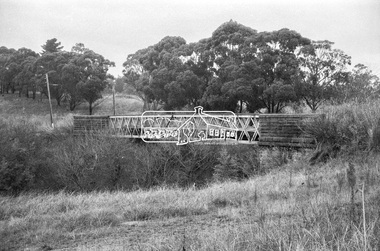
Negative - Photograph, Russell Yeoman, Old Lower Plenty Bridge, c.1970
Old bridge across the Plenty River at Lower Plenty now part of the Plenty River Trail. Part of a slide show presentation "Bridges & Waterways of the Shire" by Russell Yeoman to the 13 September 1989 Society meeting. The presentation included slides of historic photos from the Shire of Eltham Pioneers collections as well as several recent views.Roll of 35mm black and white negative film, 4 of 7 stripsIlford HP4bridge, lower plenty, main road, plenty river, plenty river trail -
 Eltham District Historical Society Inc
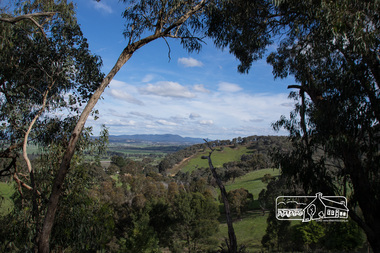
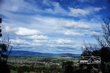
Photograph, View from Breakneck, Yarra Glen, 27 August 2016, 27/08/2016
"Until 1865, all wheeled traffic to the Upper Yarra District passed through Christmas Hills along present day Ridge and Muir roads, then followed the hazardous course of "The Breakneck" (now Breakneck Road) to the valley below. To slow the descent of wagons, logs are said to have been dragged behind. In 1865, an easier route was opened on the south side of the Yarra River, and led to the birth of Lilydale". - Christmas Hills Past and Present (Yarra Glen District Historical Society), 2004.Digital copy of colour photographfred mitchell collection, 2016, breakneck, yarra glen -
 Eltham District Historical Society Inc
Photograph, View from Breakneck, Yarra Glen, 27 August 2016, 27/08/2016
"Until 1865, all wheeled traffic to the Upper Yarra District passed through Christmas Hills along present day Ridge and Muir roads, then followed the hazardous course of "The Breakneck" (now Breakneck Road) to the valley below. To slow the descent of wagons, logs are said to have been dragged behind. In 1865, an easier route was opened on the south side of the Yarra River, and led to the birth of Lilydale". - Christmas Hills Past and Present (Yarra Glen District Historical Society), 2004.Digital copy of colour photographfred mitchell collection, 2016, breakneck, yarra glen -
 Federation University Historical Collection
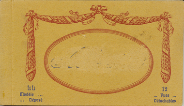
Postcard - Postcard Booklet, Levi Fils & Co, Vues Detachables
Levy Sons & Co. 1895-1919 Paris, France and London, England In 1864 the Parisian photographic studio of Ferrier pere*, fils & Soulier was bought out and became M. Leon & J. Levy. This partnership lasted until 1872 when Leon left and it was renamed J. Levy & Co., which became an important producer of stereo-views and lantern slides. By 1895 his sons had joined the company and it was renamed once again to Levy Sons & Co. (or Levy et ses Fils). His son Lucien became a well known photographer who began publishing international view-cards from his own work depicting scenes mostly from within the French empire, though quite a number are from England and there are some from Australia and Russia as well. There are few French towns that are not captured by his cards. His name does not appear on the cards but - L.L. follows the title as a photo credit. Many of their cards are not attributed. These cards were printed as colotypes in black & white, sepia, and over speckled color lithography. In 1920 the studio united with Neurdein Freres to become Levy & Neurdein reunis. Their negatives are now owned by the Roger-Viollet Photographic Agency. *Claude Marie Ferrier (1811-1889) was also an important early photographer. He was the 'Pere' in Ferrier Pere, Fils & Soulier - best remembered for their stunning series of glass views. Sorting this collection is a challenge. The postcard rears display a variety of forms - a) garland emblem with LL inside, b) with an addition emblem within (FPS?). Or c) - no emblem which may mean production by another company - however LL. remains on the front as a credit to the photographer. http://www.metropostcard.com/picslogos/pcl-levylucien.jpg.jpg http://www.unpi.com/clem/unpostcards/LON1919PC2Naback.jpg Example Colour Card circa 1920 No. 78 Paris - L'Escalier de l'Opera - LL. http://www.postcardcollector.org/forum/index.php?p=/discussion/1306/levy-fils-cie-paris-specifically-lucien-levy-llAbbeyville was a town in the Somme, so that this is a possible reason that the name has been erased on the postcard. http://www.france-voyage.com/travel-photos/abbeville-11435.htmSmall brown covered book of 12 postcards with views of Abbeyville in the Somme. Issue between each each individual postcard. The cover has an oval on front and the name "Abbeyville" in its centre has been erased. The name of the town has also been erased (censored) throughout the booklet. There is a garland in maroon around the maroon oval on the front cover. Print in dark grey on bottom left and right hand side corners.Print "Modele ... Depose" in dark grey on bottom left and "12 Vues Detachables" on right hand side corners. Names of places printed inside but the name of the town has been erased throughout. "Carte Postale" with logo underneath at centre and "Correspondence" LHS and "Adresse" RHS on top of verso of each postcard in booklet. "Levy Fils & Co, Paris sideways along centre line of postcard on verso.abbeyville, levy fils, postcard, vues, panorama, place de l'amiral-courbet, monument, rue alfred-cendre, alfred-cendre street, statue, saint vulfran church, saint gilles church, museum, prarona statue, avenue de la gars, avenue of the station, chevalier de la barre, river somme, somme, talence bridge, correspondence, carte postale, censor, censored -
 Federation University Historical Collection
Book, Powell & Co, Guide to Ballarat the Beautiful, 1906, 1906
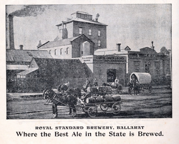
A book highlighting Ballarat and surrounds for visiting tourists. Green, black and red soft covered book of 50 pages. The book includes many illustrations and advertisements. Themes of the book include: Ballarat and district, Lake Wendouree, Ballarat Botanical Gardens, Statues, gold and mining, Ballarat gold nuggets, Eureka Stockade, Ballarat School of Mines, Hepburn Lagoon, Emu River, race courses, Art gallery of Ballarat Advertisements include: Dr Lem Chinese Practictioner, Eureka Aerated Waters & Brewing Co., Sunshine Harvester, Gordon Bros., Long's biscuits, South Street, Grand National Eisteddfod of Australia, Lake View Hotel, Carlyon's Hotel, Clarendon Ladies' College, J.E. Sang Chinese Doctor and Herbalist, Reid's Ballarat Coffee Palace, Robert Sim & Co Timber Merchants, Cobb & C0 livery and stables Ballarat, Eagle Foundry, Fred A. Reed Tobacconist, Heinz bros butchers, J.J. Goller & Co. Illustrations include: Craig's Royal Hotel, McBride's Boots, John Lavis Cordial Manufacturer, R. Graham & Sons tanners, Lester's hotel, Sun Foundry, Central business College, Edwards Pyrites & Ore Reduction Co., George Farmer, Sturt Street (colour), Lake Wendouree, Ballarat East Town Hall, Lake Burrumbeet, Queen Victoria Statue, Fairy Land, Ballarat Botanical Gardens, Lal Lal Falls, Moorabool Falls, Kirks Dam, Lake Wendouree and paddle boat, Lydiard Street, Bopeep Creek, Star of the East Mine, Peter Lalor Statue, great Equatorial Telescopu at Oddie Observatory (Ballarat Observatory), Boer War monument, Entrance to Art Gallery of Ballarat, interior of Art Gallery of Ballarat, Old Curiosity Shop, Angus Rialto cafe, Ballarat Brewing Co, Royal Standard brwery, Phoenix Brewery Warrenheip, John MacLeod and Companyballarat, ballarat school of mines, buninyong, burrumbeet, cobb and co, eureka brewery, ballarat brewing co, sturt street, m1604, chinese, chinese medicine, d. lem, j.e. sang, brewery, tanners -
 Federation University Historical Collection
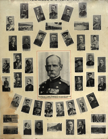
Photograph - Photo-montage, Officers of Forces in South Africa (Boer War), c1900
... are supplemented with views of: Modder River, Ladysmith, Railway Bridge... Forces during the Boer War. Portraits are supplemented with views ...The Boer War was fought from 1899 to 1901.Black and white printed photo montage of Officers who served in the South African Forces during the Boer War. Portraits are supplemented with views of: Modder River, Ladysmith, Railway Bridge of Tugela, 4.7 naval gun, Royal Horse Artillery, Johannesburg Fort, Howitzer Gun, Field Artillery. The poster produced as an advertising medium for Wills Tobacco and Cigarettes using the Transvaal Series of cards.boer war, south african war, armed services, lord roberts, weapons, alfred milner, cecil rhodes, w.p. schreiner, w. hely hutchinson, w.p. symons, general mildyard, a. hunter, holled smith, dick-cunnynghame, f. roberts, charles warren, brabazon, a.g. wauchope, kelly-kenny, hector mcdonald, baden-powell, lord methuen, f. carrington, n.g. lyttleton, f. howard, j.d.f. french, w.f. gatacre, h.s. rawlinson, eyre crabbe, alderson, kekewich, a. fitzroy hart, g. white, lord kitchener, lord dundonald, plumer, h.m.l. rundle, w.h. mackinnon, h.e. colville, f. forestier walker, r. clements, redvers buller, h. chermside, g. lyttelton -
 Flagstaff Hill Maritime Museum and Village
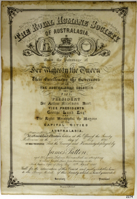
Award - Certificate of Merit, Royal Humane Society of Australia, James Patten, 21-05-1890
The Bronze Medal and Certificate of Merit of the Royal Humane Society of Australasia were awarded to James Patten for the bravery he displayed on 18th April 1890, and presented to him on 21st May 1890. The Royal Humane Society of Australasia was founded in 1874 with the aim to recognise those who risked their lives to save others and to assist those whose acts of bravery caused them or their surviving dependants to be disadvantaged in some way. The producers of the certificate were Fergusson & Mitchell, a Melbourne organisation established by 1858 that was an engraver, lithographer and printer. Details of the incident were published in the Argus, Saturday 19 April 1890, page 11 - "FATAL BOATING ACCIDENT, (BY TELEGRAPH FROM OUR CORRESPONDENT.), WARRNAMBOOL, FRIDAY A fatal boating disaster occurred in Lady Bay this morning, the victim being Joseph Lowe, licensee of the Bay View Hotel, South Warrnambool. The deceased, in company with two lads named James Ferrier and James Patten, went out in a small dingy to shoot musk ducks. The water was perfectly smooth, and the party were tempted to proceed as far as the mouth of the Hopkins River. In their eagerness they neglected to keep clear of the breakers, and were presently carried in on the crest of a large wave, and the boat cap sized within a cable's length of the shore, precipitating the occupants into the water. Patten and Lowe stuck to the overturned boat, Ferrier striking out for the shore, which he reached in an exhausted state. In the meantime his companions had been washed off the boat, and were struggling in the breakers. Lowe was unable to swim, and Patten kept him afloat, at the same time making gallant attempts to get him ashore, but finally had to leave him to his fate. Ferrier, seeing Lowe's danger, undressed and swam out, but became exhausted. Ferrier and Patten were both found in a fainting condition by persons who saw the catastrophe from the jetty, and ran along the beach to render assistance. Attempts were subsequently made to rescue Lowe's body, which could be seen washing abort in the surf. These proved unsuccessful, and no hope is now entertained of recovering it. Lowe was a smart young man, 28 years of age, and unmarried. He was formerly bar-man at the Commercial Hotel here, having been engaged in Melbourne...." The bronze medal and accompanying certificate of the Royal Humane Society of Australasia recognise the bravery of James Patten, a Warrnambool citizen who risked his life in the attempt to save the life of his friend Joseph Lowe.Certificate, cream paper, rectangular, decorative border and headings, printed and handwritten in pen and ink. Letterhead of The Royal Humane Society of Australasia. Awarded on 21st May 1890 to James Patten of Warrnambool. for his bravery on 18th April 1890.Print and writing includes - "The Royal Humane Society of Australia under the patronage of Her Majesty the Queen and their excellencies, the Governors of all the Australian Colonies and Fiji. At a general court of directors holden at the Offices of the Society Melbourne on the 21st day of May 1890, it was resolves that the courage and humanity displayed by James Patten, aged 20 years, labourer Warrnambool in attempting to rescue Joseph Lowe from drowning in the North Eastern bight of Lady Bay 18th April 1890. Call for the admiration of this court and justly, entitles him to the Bronze Medal of this society which is hereby awarded." Signatures [Secretary] and [President]flagstaff hill, warrnambool, flagstaff-hill, maritime museum, maritime village, shipwreck-coast, flagstaff hill maritime museum & village, bronze medal 1890, royal humane society of australasia, james patten, medal, australian award medal, commemorative medal, numismatics, life saving, lifesaving, rescue, bravery, drowning, joseph lowe, james ferrier, lady bay, hopkins river, boating accident, certificate of merit, lithograph, north eastern bight -
 Flagstaff Hill Maritime Museum and Village
Award - Medal, James Patten, 18-041890
The Bronze Medal and Certificate of Merit of the Royal Humane Society of Australasia were awarded to James Patten for the bravery he displayed on 18th April 1890, and presented to him on 21st May 1890. The Royal Humane Society of Australasia was founded in 1874 with the aim to recognise those who risked their lives to save others and to assist those whose acts of bravery caused them or their surviving dependants to be disadvantaged in some way. Details of the incident were published in the Argus, Saturday 19 April 1890, page 11 - "FATAL BOATING ACCIDENT, (BY TELEGRAPH FROM OUR CORRESPONDENT.), WARRNAMBOOL, FRIDAY A fatal boating disaster occurred in Lady Bay this morning, the victim being Joseph Lowe, licensee of the Bay View Hotel, South Warrnambool. The deceased, in company with two lads named James Ferrier and James Patten, went out in a small dingy to shoot musk ducks. The water was perfectly smooth, and the party were tempted to proceed as far as the mouth of the Hopkins River. In their eagerness they neglected to keep clear of the breakers, and were presently carried in on the crest of a large wave, and the boat cap sized within a cable's length of the shore, precipitating the occupants into the water. Patten and Lowe stuck to the overturned boat, Ferrier striking out for the shore, which he reached in an exhausted state. In the meantime his companions had been washed off the boat, and were struggling in the breakers. Lowe was unable to swim, and Patten kept him afloat, at the same time making gallant attempts to get him ashore, but finally had to leave him to his fate. Ferrier, seeing Lowe's danger, undressed and swam out, but became exhausted. Ferrier and Patten were both found in a fainting condition by persons who saw the catastrophe from the jetty, and ran along the beach to render assistance. Attempts were subsequently made to rescue Lowe's body, which could be seen washing abort in the surf. These proved unsuccessful, and no hope is now entertained of recovering it. Lowe was a smart young man, 28 years of age, and unmarried. He was formerly bar-man at the Commercial Hotel here, having been engaged in Melbourne ..." This medal recognises the bravery of James Patten, a local citizen who risked his life to save the life of his friend Joseph Lowe whilst at sea and was recognised for this act by the Royal Humane Society of Australasia.Medal awarded to James Patten by the Royal Humane Society of Australasia for his bravery on18 April 1890 and presented to him on 21 May 1890. Bronze medal in hard black rectangular case. Lid and base have centre hinge and brass spring button catch. Case is padded and lined with blue silk and has a fitted hook. The round medal has a bronze bar with pin closure, dark blue, braided ribbon with brass swivel mount. The case has a gold embossed rectangular border on the lid and base. Embossed inscription on lid. The obverse shows a woman on the left in long robe placing a wreath on the head of a kneeling man at right, with the five stars of the Southern Cross constellation above his head. A motto is inscribed around the edge. The reverse has inscriptions around the edge, a wreath of two overlapping olive branches, and engraved text.OBVERSE: Embossed around "VIRTUTE PARATUM" REVERSE: Embossed on the medal around the edge "ROYAL HUMANE SOCIETY OF AUSTRALASIA INSTD. A.D. 1874", in the centre "AWARDED TO" Engraved in the centre "James Patten/ 18th April / 1890" CASE LID: "PRESENTED BY / THE ROYAL HUMANE SOCIETY / OF AUSTRALASIA / TO / JAS. PATTEN. / 21ST MAY 1890."flagstaff hill, warrnambool, flagstaff-hill, maritime museum, maritime village, shipwreck-coast, flagstaff hill maritime museum & village, bronze medal 1890, royal humane society of australasia, james patten, medal, australian award medal, commemorative medal, numismatics, life saving, lifesaving, rescue, bravery, drowning, joseph lowe, james ferrier, lady bay, hopkins river, boating accident, certificate of merit, north eastern bight -
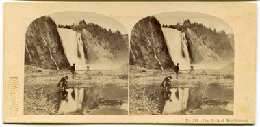 City of Moorabbin Historical Society (Operating the Box Cottage Museum)
Leisure object - Stereograph card, The Falls of Montmorenci, Quebec, 1908
The London Stereoscopic and Photographic Company began in 1854 as the London Stereoscope Company (LSC), from 1856 was known as the London Stereoscopic Company, and from May 1859 as the London Stereoscopic and Photographic Company.This card is from the collection of a pioneer family of the City of Moorabbin.Stereograph Card manufactured by 'The London Stereoscopic Company' 54 Cheapside - black and whiteThe Falls of Montmorenci, near Qubec, Canada "These beautiful falls are eight miles distant from Quebec, on the Montmorenci river and situated at a point where the river is sixty feet wide. The descent of the torrent is 250 feet higher than those of Niagra, but only about fifty feet in width. The effect of the view of these falls upon the beholder is most delightful. The river at some distance seems suspended in the air, in a sheet of billowy foam. The water which first breaks over the ledge in on sheet is more and more divided as it plunges against the successive layers of rock, which it almost completely veils from view; the spray becomes very delicate and abundant, from top to bottom, hanging over, and revolving round the torrent, till it becomes lighter and more evanescent than the whitest fleecy clouds of summer." In the winter time the spray form the fall freezes in the form of a cone to a height of nearly 100 feet, and at such time the falls a greatly resorted to for the amusement of sliding down the cone with the tobogen, or Indian sleigh. The comparatively short distance from the city and the extreme beauty of the scenery along the whole route, render these falls an attractive scene for the inhabitants, who account a visit amongst their usual recreations.quebec, canada, the falls of montmorenci, moorabbin, stereograph cards -
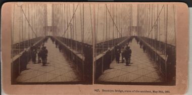 Bendigo Historical Society Inc.
Photograph - HARRIS COLLECTION: STEREOSCOPIC VIEWS, Nineteenth Centur
Stereoscopic views. Kilburn Brothers Littleton , N H. 1. Trinity college Dublin. 2. Brooklyn Bridge, scene of the accident , May 30th 1883. 3. Spinning Room , Mechanics Mill, Fall River Mass. 4. Bay Grove Hill, Greenwood Cemetery, Brooklyn, N Y. 5.Crossing the Great Suspension Bridge, by rail. 6. Dining Hall , Grand Union Hotel, Saratoga, Largest Dining Hall in the World. 7. Phantom Leaves. 8. Full Moon. 9. Merced River, Yo-Semite , Cal. 10. I Breathe Inspiration. 11. United States Hotel Park, Saratoga.Kilburn Brothers Littleton N H.photography, viewers -
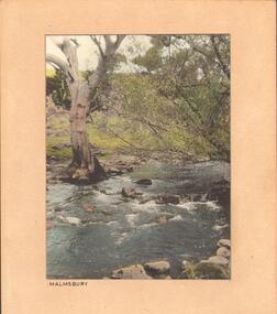 Bendigo Historical Society Inc.
Photograph - STREAM AT MALMSBURY
Photograph, hand tinted. Stream at Malmsbury (Coliban River). History: with note 'Photographs from Mrs Ella Bourke, 131 Barnard St, Bendigo, ph 438269'. Photographs Francis (Frank) Thomas Kennedy'. James Lerk 'Coliban River'??Francil (Frank) Thomas Kennedyplace, landscape view, see also 2001.152.01, 2001.153.01, 2001.154.01, 2001.157.01, 2001.158.01, 2001.159.01, 2001.160.01, 2001.162.01 -
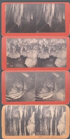 Bendigo Historical Society Inc.
Photograph - WES HARRY COLLECTION: 4 STEROEGRAPHIC CARDS, ?
Four Stereographic cards, all showing views inside of the Jenolan Caves. On the reverse is stamped ' Picturesque Stereoscopic Views of Jenolan Caves and Blue Mountains, Photographed and Published by J. Rowe, Jenolan Caves., (a) Queens Diamonds , (b) Decent to River , (c) Shawls , (d) Jersey Castle ?J. Roweplace, jenolan caves, j. rowe, jenolan caves, blue mountains, stereoscopic views, queens diamonds, decent to river , shawls -
 Bendigo Historical Society Inc.
Document - MALONE COLLECTION: GREETING CARDS, 5/2/1910
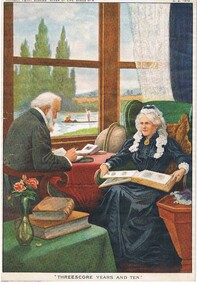
Coloured picture of an elderly man & lady. The man is wearing a grey suit. He has grey hair and beard. He is sitting at a table with a red cloth on it. He is reading a book and has some others on the table. The lady is wearing a black dress and a gold medallion necklace. She is wearing a lace cap which extends past the medallion. She has an open photo album on her lap. She is sitting in a green armchair with a brown cushion. Beside her is a brown table and in front of her is a small table with a green cloth. It has two large books and a tall green vase of pink roses on it. The view outside the window is of a stream with two people in it. One man is standing up and using a pole to guide the boat. At the top is printed 'Horner's Penny Stories 'River of Life' Series No 4. 5. 2. 1920. The picture is titled 'Threescore Years and Ten'. On the back is written 'MP277.MP277personal effects, greeting cards, malone collection, malone collection, greeting cards, horner's penny stories 'river of life' series no 4 -
 Bendigo Historical Society Inc.
Document - J W SWATTON COLLECTION: PHOTOGRAPHIC BOOKLET
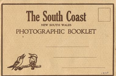
The South Coast New South Wales Photographic Booklet has a light brown rippled cover with dark brown printing and frame with two kookaburras in the bottom left corner. 1940 written in the bottom right corner. On the back it has From and Published by the Valentine Publishing Co. Pty. Ltd., Sydney and Melbourne. The inside has a panorama view from Sublime Point and smaller views of the South Coast, Mt Kiera Raod, Wollongong, Bulli Pass, the Harbour Wollongong, Austinmer, The Blowhole Kiama, near Sublime Point, The Bridge Shoalhaven river Nowra,person, receipts, j w swatton, j w swatton collection, the south coast nsw, the valentine publishing co pty td, sublime point, stanwell park, wollongong, bulli pass, thirroul, austinmer, the blowhole kiama, nowra -
 Port Melbourne Historical & Preservation Society
Photograph - Aerial view, Fishermen's Bend, 1947
Aerial photo of Fishermen's Bend with Footscray in foreground, Maribyrnong River and varous airfields upper left. c1947fishermans bend, footscray -
Port Melbourne Historical & Preservation Society
Photograph - Aerial view Maribyrnong and Yarra rivers and Coode Island, c. 1976
... Aerial view Maribyrnong and Yarra rivers and Coode Island ...Donated to City of Port Melbourne by Councillor Russell GRIFFITHS.Aerial photograph taken from above junction of Yarra and Maribyrnong rivers showing oil and chemical storage farm at Coode Island and four container vessels at Swanson Dock.transport - shipping, piers and wharves - miscellaneous, swanson dock